LandCode
Douglas CountyUnified Development Code

Article 4 — Lot and Building Standards

current as of 2026-02-18verified current · checked 2026-08-24Officialofficial source32 sections · full chapter
§ 4.01

General Provisions

Sec. 4.01 General Provisions The intent of the Residential Districts is to protect established residential neighborhoods as well as promote well designed and properly located future residential developments.

The district provisions discourage any use that would substantially interfere with the residential nature of the districts. Compatible park, open space, utility and civic uses are permitted in Residential Districts as identified in Article 2, Uses, Use Regulations and Restrictions.

§ 4.02

Interpretation

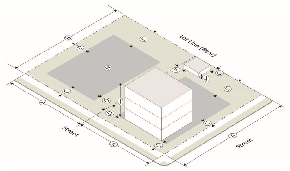
Sec. 4.02 Interpretation The following graphics depict the interpretation of lot development standards. The official definitions for these terms can be found in the Article 15, Interpretations and Definitions.

Ⓐ Lot Width Ⓕ Accessory Side Yard Setback Ⓑ Lot Depth (Interior or Through Lot Only Ⓖ Accessory Rear Yard Setback Ⓒ Principal Building Front Yard Setback Ⓗ Buildable Area Ⓓ Principal Building Side Yard Setback Ⓘ Principal Building Maximum Height Ⓔ Principal Building Rear Yard Setback Ⓙ Accessory Building Maximum Height
§ 4.03

AG, Agricultural District.

Sec. 4.03 AG, Agricultural District.

A.Purpose The AG Rural Agricultural District is established to protect rural areas of Douglas County in which agriculture, farm operations, conservation lands and timber stands on parcels of 5 acres or more are the established land use pattern, and to provide an environment which encourages residents to continue to live and practice agricultural operations without adverse impact arising from more dense development.
B.Lot Development Standards
Table 4.03-1
Lot Dimensions
Minimum Lot Area5 Acres
Minimum Lot Width150’ at building setback line on sewer or septic
Minimum Lot Frontage on ROW50’ is the standard unless a lot is approved as a Minor Exempt Subdivision 35’ if fronting on a cul-de-sac
Maximum Density0.2 dwelling units/acre on sewer or septic
Minimum Setbacks
Principal Building
Front100’ from Major Thoroughfare or 35 from a Minor Street’
Side15’
Rear60’
Accessory Building
From Principal Structure10’
FrontNot-Permitted unless 100’ from the street right-of-way
Side5’ if less than 200 sf Same as principal if greater than 200 sf
Rear
Maximum Height
Principal2.5 stories or 35’
Accessory20’
Minimum Floor Area
Single Family Detached1,800 sf
Minimum Dimension
Single Family Detached16’ in width
Maximum Impervious SurfaceWithin the Dog River Primary Basin 18%, and Dog River Secondary Basin 25%, within the Bear Creek Basin 25%, within all other Basins no restrictions
Coverage
Reading grid · rebuilt for display · verify at source (p. 3)
§ 4.04

R-A Residential-Agricultural District

Sec. 4.04 R-A Residential-Agricultural District

A.Purpose The R-A Residential-Agricultural District is established to protect and promote a suitable environment for rural or “large lot suburban” family life, agriculture including the raising of livestock and poultry, and the development of natural resources and other uses requiring extensive areas of land. This District is required to protect the future development of land in accordance with the Comprehensive Plan of the county as amended.
B.Lot Development Standards
Table 4.04-1
Lot Dimensions
Minimum Lot Area1 acre on sewer or septic
Minimum Lot Width150’ at building setback line on sewer or septic
Minimum Lot Frontage on ROW50’ is the standard unless a lot is approved as a Minor Exempt Subdivision 35’ if fronting on a cul-de-sac
Maximum Density.85 Dwelling Units per acre on sewer or septic
Minimum Setbacks
Principal Building
Front100’ from Major Thoroughfare or 35’ from a Minor Street’’
Side15’
Rear60’
Accessory Building
From Principal Structure
FrontNot-Permitted unless 100’ from the street right-of-way
Side5’ if less than 200 sf Same as principal if greater than 200 sf
Rear
Maximum Height
Principal2.5 stories or 35’
Accessory20’
Minimum Floor Area
Single Family Detached1,800 sf
Minimum Dimension
Single Family Detached16’ in width
Maximum Impervious Surface CoverageWithin the Dog River Primary Basin 18%, and Dog River
Secondary Basin 25%, within the Bear Creek Basin 25%,
within all other Basins no restrictions
Reading grid · rebuilt for display · verify at source (p. 5)
§ 4.05

R-LD Low Density Single-Family Residential District.

Sec. 4.05 R-LD Low Density Single-Family Residential District.

A.Purpose The R-LD Single-Family Residential District is established to protect and promote a suitable environment for family life, to discourage any use which would generate other than normal residential area traffic on minor streets and to protect the orderly future development of land in accordance with comprehensive development plans for the county.
B.Lot Development Standards
Table 4.05-1
Lot Dimensions
Minimum Lot Area33,000 sq. ft. on septic; 15,000 sq. ft. on central sewer
Minimum Lot Width80 feet on central sewer; 100 feet on septic
Minimum Lot Frontage50’ is the standard unless a lot is approved as a Minor Exempt Subdivision 35’ if fronting on a cul-de-sac
Maximum Density1.63 dwelling units/acre on septic; 2.29 du/acre on central sewer
Minimum Setbacks
Principal Building
Front100’ from Major Thoroughfare; 35 from Minor Street’
Side15’
Rear30’
Accessory Building
From Principal Structure
FrontNot-Permitted unless 100’ from the street right-of-way
Side5’ if less than 200 sf Same as principal if greater than 200 sf
Rear
Maximum Height
Principal35’
Accessory20’
Minimum Floor Area
Single Family Detached1,800 sf
Maximum Lot Coverage40%
Maximum Building Separation
Maximum Impervious SurfaceWithin the Dog River Primary Basin 18%, and Dog River
CoverageSecondary Basin 25%, within the Bear Creek Basin 25%,
within all other Basins no restrictions
Reading grid · rebuilt for display · verify at source (p. 7)
§ 4.06

R-MD Medium Density Single-Family Residential District

Sec. 4.06 R-MD Medium Density Single-Family Residential District

A.Purpose The R-MD Medium Density Single-Family Residential District is established to protect and promote a suitable environment for family life, to discourage any use which would generate other than normal residential area traffic on minor streets and to protect the future development of land in accordance with comprehensive development plans for the county.
B.Lot Development Standards
Table 4.06-1
Maximum Impervious SurfaceWithin the Dog River Primary Basin 18%, and Dog River
CoverageSecondary Basin 25%, within the Bear Creek Basin 25%,
within all other Basins no restrictions

Minimum Setbacks Principal Building Front yard 100’ from major arterial; 35’ from minor street Side yard 15’

Rear yard 30’

Between Structures (Duplex) 0’ allowed between attached units Between Buildings (Duplex) 20’ feet of separation is required between buildings Accessory Building From Principal Structure 10’

Front Not Permitted Side 5’ if less than 200 sf 15’ if greater than 200 sfRear Maximum Height Principal 35’

Accessory Two stories or 26’

Minimum Floor Area Single Family Detached 1,800 sf per dwelling unit Efficiency or one-bedroom – Duplex unit 750 sf Two-bedroom – Duplex unit 1,050 sf Three or more-bedroom – Duplex unit 1,500 sf Maximum Lot Coverage 40% Maximum Building Separation Maximum Impervious Surface Coverage Within the Dog River Primary Basin 18%, and Dog River Secondary Basin 25%, within the Bear Creek Basin 25%, within all other Basins no restrictions

C.Supplemental Regulations
1.Principle and Accessory use regulations shall be as established in Article 2, Use of Land and Structures and Article 3, Restrictions on Particular Uses.
2.Density Bonus-Developers who apply the performance standards listed below to multi-family and townhome-condominium residential projects that are connected to central sewer facilities are allowed up to a 15% density bonus. Utilizing these standards and receiving this density bonus must be approved prior to any project commencement, and any alteration to those standards may result in revocation of the density bonus. To achieve the full density bonus, each item below will be credited toward 10% of the total number of units allowed under the bonus. To achieve 100% of the density bonus, all ten standards must be satisfied.
a.Provision at least one bicycle indoor, protected bicycle parking space per 3 dwelling units;
b.Provision of at least one electric vehicle charging station per 50 parking spaces;
c.Provision of community accessible meeting spaces for tenant use. Meeting spaces shall have internet and phone capacity;
d.Provision of a fenced community garden with access to water and a storage area for tools and supplies. The community garden shall be a permanent fixture and identified on all site plans and shall be in addition to other required greenspace;
e.Provision of a fully fenced and secure Dog Park for the specific use of resident’s pets.
f.Accessible units meeting Americans Disability Act (ADA) certification in the amount of 25% of total units proposed;
g.Transit-oriented amenities providing access to community transit systems;
h.Construction of structures using LEED, Enterprise Green Communities, EarthCraft, and GreenPoint Rated green building certification programs;
i.Installation of Energy Star rated appliances at the time of purchase or occupancy; and
j.Installation of supplemental Solar Photovoltaic Power generation capacity in the minimum amount of 1.2kW per dwelling unit for a minimum of 50% of units proposed.
3.Traffic Study Required. A traffic study shall be required by the developer to determine the impact of the proposed development on the existing roadway system if the number of dwelling units exceeds 50 dwelling units (See Article 15 Traffic Study definition for required components).
D.Cross References for Article 3 The references below are to sections of this Code that contain dimensional requirements specific to this zoning district.
1.Cross reference Article 3, Section 313 for Standards for Accessory Buildings, Uses and Structures
E.Cross References for Article 4, Division V
1.Cross reference Article 4, Division V, Section 4.28 for Minimum Lot Frontage requirements in general; Section 4.28(b) for Minimum Lot Frontage for large lots; Section 4.28(c) for Exceptions to minimum lot frontage requirements; and Section 4.28(d) for Street Frontage requirements.
2.Cross reference Article 4, Division V, Section 4.29 (a-d) for Residential Density and Lot Area requirements.
3.Cross reference Article 4, Division V, Section 4.31 (a-b) for Minimum Lot Size requirements for properties with septic tanks.
4.Cross reference Article 4, Division V, Section 4.32 (a-b) for Minimum Lot Width requirements.
5.Cross reference Article 4, Division V, Section 4.33 (a-b) for Minimum setback requirements for principle buildings.
6.Cross reference Article 4, Division V, Section 4.34 for Minimum setback requirements for accessory buildings.
7.Cross reference Article 4, Division V, Section 4.35 (a-b) for Minimum Floor Area per dwelling unit requirements.
8.Cross reference Article 4, Division V, Section 4.36 (a-b) for Maximum Building and Structure Height requirements.
9.Cross reference Article 4, Division V, Section 4.37 (a-e) for Solar Energy Equipment requirements.
10.Cross reference the Douglas County Standard Design Details Supplemental Appendix for additional information on design standards in the Residential Medium Density (R-MD) District.
Reading grid · rebuilt for display · verify at source (p. 10)
§ 4.07

R-HD Residential – High Density Residential District

Sec. 4.07 R-HD Residential – High Density Residential District

A.Purpose The R-HD Residential High Density District is established to protect and promote a suitable environment for family life, to discourage any use which would generate other than normal residential area traffic on minor or collector streets, to meet the demands of two, three, four and multi-family residences, townhomes and condominiums and to protect the orderly future development of land in accordance with comprehensive development plans for the county. The intent of this district is to provide standards for higher density dwellings which will:
(1)Be located primarily in areas near or adjacent to low-density or medium density residential use areas;
(2)Be located near such services as retail shopping and major thoroughfares and collector streets;
(3)Be located to provide transition between single-family use areas and higher density dwelling areas and/or commercial areas;
(4)Encourage the provision of usable open space and recreation areas and a desirable living environment;
B.Lot Development Standards
Table 4.07-1
total acreagetotal acreage
BUILDING [Principal & Accessory Buildings & Structures]
Building height, max45 FT45 FT3 floors or 50’3 floors or 50’
Building height, min2 stories
Building floor area, one-bedroom unit, min560 SF--
Building floor area, two-bedroom unit, min650 SF--
Building floor area, three-bedroom unit or more, min1050 SF--
Building floor area, townhouse Condominium, min-1300 SF1300 SF-
Multi-Family Floor Area Minimums
Building floor area, efficiency unit, min--560 SF
Building floor area, one-bedroom unit, min--650 SF
Building floor area, two-bedroom unit, min--900 SF
Building floor area, three-bedroom unit or more, min--1100 SF
Within the Dog River Primary Basin 18%, and
Maximum Impervious Surface CoverageDog River Secondary Basin 25%, within the
Bear Creek Basin 25%, within all other Basins
no restrictions

fee simple with lot)

Townhous e (unit fee simple with lot)

Condom iniums (unit without lot)

Multi-family (units are rental)

LOT

Lot size, minimum area per dwelling unit 5445 SF 1000 SF N/A N/A Lot width, minimum 50 FT 20 FT N/A Lot frontage, minimum 50 FT 20 FT N/A 50 FT DENSITY Dwelling units per acre on sewer 8 8 8 8 Dwelling units per acre on septic 2 Not Allowed Not Allowed Not allowed YARD [Principal Building] Front setback, major thoroughfare, minimum 50 FT 50 FT 50FT 50 FT Front setback, minor street, minimum 25FT 25 FT 25FT 25 FT Side setback, minimum between units/from property line 0/10 FT 0/10 FT 0/10 FT 0/10 FT Rear setback, minimum between units/from property line 20 FT 20 FT 20 20 FT Required Minimum Private Usable Open Space/balcony/patio/yard for each Dwelling Unit Provided integral or Contiguous to each unit 10% of unit size 10% of unit size Required Minimum Open Space for the Development 20% of 20% of total acreage total acreage BUILDING [Principal & Accessory Buildings & Structures] Building height, max 45 FT 45 FT 3 floors or 50’

3 floors or 50’

Building height, min 2 stories Building floor area, one-bedroom unit, min 560 SF - -Building floor area, two-bedroom unit, min 650 SF - -Building floor area, three-bedroom unit or more, min 1050 SF - -Building floor area, townhouse Condominium, min - 1300 SF 1300 SF -Multi-Family Floor Area Minimums Building floor area, efficiency unit, min - - 560 SF Building floor area, one-bedroom unit, min - - 650 SF Building floor area, two-bedroom unit, min - - 900 SF Building floor area, three-bedroom unit or more, min - - 1100 SF Maximum Impervious Surface Coverage Within the Dog River Primary Basin 18%, and Dog River Secondary Basin 25%, within the Bear Creek Basin 25%, within all other Basins no restrictions

G.Supplemental Regulations
1.Principle and Accessory use regulations shall be as established in Article 2, Use of Land and Structures and Article 3, Restrictions on Particular Uses.
2.Density Bonus-Developers who apply the high-performance standards listed below to multi-family and townhome-condominium residential projects are allowed up to a 25% density bonus.

Utilizing these standards and receiving this density bonus must be approved prior to any project commencement, and any alteration to those standards may result in revocation of the density bonus. To achieve the full density bonus, each item below will be credited toward 10% of the total number of units allowed under the bonus. To achieve 100% of the density bonus, all ten standards must be satisfied.

a.Provision at least one bicycle indoor, protected bicycle parking space per 3 dwelling units.
b.Provision of at least one electric vehicle charging station per 50 parking spaces.
c.Provision of community accessible meeting spaces for tenant use. Meeting spaces shall have internet and phone capacity.
d.Provision of a fenced community garden with access to water and a storage area for tools and supplies. The community garden shall be a permanent fixture and identified on all site plans and shall be in addition to other required greenspace.
e.Provision of a fully fenced and secure Dog Park for the specific use of resident’s pets.
f.Accessible units meeting Americans Disability Act (ADA) certification in the amount of 25% of total units proposed.
g.Transit-oriented amenities providing access to community transit systems.
h.Construction of structures using LEED, Enterprise Green Communities, EarthCraft, and GreenPoint Rated green building certification programs.
i.Installation of Energy Star rated appliances at the time of purchase or occupancy; and
j.Installation of roof-mounted supplemental Solar Photovoltaic Power generation capacity in the amount of 1.2kW per dwelling unit for a minimum of 50% of units proposed.
3.Traffic Study Required. A traffic study shall be required by the developer to determine the impact of the proposed development on the existing roadway system if the number of dwelling units exceeds 50 dwelling units (See Article 15 Traffic Study definition for required components).
D.Cross References for Article 3 The references below are to sections of this Code that contain dimensional requirements specific to this zoning district.
1.Cross reference Article 3, Section 313 for Standards for Accessory Buildings, Uses and Structures
E.Cross References for Article 4, Division V
1.Cross reference Article 4, Division V, Section 4.28 for Minimum Lot Frontage requirements in general; Section 4.28(b) for Minimum Lot Frontage for large lots; Section 4.28(c) for Exceptions to minimum lot frontage requirements; and Section 4.28(d) for Street Frontage requirements.
2.Cross reference Article 4, Division V, Section 4.29 (a-d) for Residential Density and Lot Area requirements.
3.Cross reference Article 4, Division V, Section 4.31 (a-b) for Minimum Lot Size requirements for properties with septic tanks.
4.Cross reference Article 4, Division V, Section 4.32 (a-b) for Minimum Lot Width requirements.
5.Cross reference Article 4, Division V, Section 4.33 (a-b) for Minimum setback requirements for principle buildings.
6.Cross reference Article 4, Division V, Section 4.34 for Minimum setback requirements for accessory buildings.
7.Cross reference Article 4, Division V, Section 4.35(b) for Minimum Floor Area per dwelling unit requirements.
8.Cross reference Article 4, Division V, Section 4.36 (a-b) for Maximum Building and Structure Height requirements.
9.Cross reference Article 4, Division V, Section 4.37 (a-e) for Solar Energy Equipment requirements.
10.Cross reference the Douglas County Standard Design Details Supplemental Appendix for additional information on design standards in the Residential High Density (R-HD) District.
Reading grid · rebuilt for display · verify at source (p. 13)
§ 4.08

R-MH Manufactured Home Residential District

Sec. 4.08 R-MH Manufactured Home Residential District

A.Purpose The R-MH Manufactured Home Residential District is established to protect and promote a suitable environment for family life, to meet the need and demands for the development of manufactured home residential areas and to protect the future development of land in accordance with comprehensive development plans for the county.
B.Lot Development Standards
Table 4.08-1
Site Area
Manufactured Home Park initial site requires 20 acres Manufactured Home Subdivision initial site requires 50 acres
Lot Dimensions
Minimum Lot Area15,000 sf 4,500 sf per unit for MH Park allowed on sewer only
Minimum Lot Widthn/a
Minimum Lot Frontage50’
Maximum Density MH SubdivisionOn Sewer 2.95 DU/acre; On Septic 1.63 DU/acre
Maximum Density MH ParkOn Sewer 6 DU/acre; On Septic not allowed
Minimum Setbacks
Principal Building
Front15’
Side7.5’ 5’ if common shared yard is approved
Rear30’
Accessory Building
From Principal Structure
FrontNot-Permitted
Side5’ if less than 200 sf 15’ if greater than 200 sf
Rear
Maximum Height
Principal2.5 stories or 35’
Accessory20’
Minimum Floor Area
Site Built Single Family Detached1,800 sf
Manufactured Home on an Individual Lot1,300 sf
Manufactured Home in a Manufactured Home Park900 sf
Impervious Surface Coverage Max60%
Maximum Impervious SurfaceWithin the Dog River Primary Basin 18%, and Dog River
CoverageSecondary Basin 25%, within the Bear Creek Basin 25%,
within all other Basins no restrictions
Reading grid · rebuilt for display · verify at source (p. 15)
§ 4.09

PRD Planned Residential Development

Sec. 4.09 PRD Planned Residential Development

A.Purpose The PRD district is established to protect and promote a suitable environment for family life and to encourage flexibility in meeting the needs of families. This District facilitates a mix of residential opportunities from single-family detached through attached single and multi-family dwellings in accordance with the land use plan for the County. These plans may supersede the regulations included in Articles 1-15 of the Unified Development Code (UDC) where indicated by these development plans. Otherwise, the standards of this Code will govern. The intent of this district is to provide standards for higher density dwellings at the edges of existing municipal boundaries where public water and sewer infrastructure exist and arterial corridor frontage is available providing for higher density developments which will:
(1)To provide flexibility, unity, and diversity in land planning and development, resulting in convenient and harmonious groupings of uses, structures and common facilities;
(2)Be located near such services as retail shopping and on major thoroughfares and collector streets.
(3)Be located to provide transition between single-family use areas and these higher density dwelling areas and/or commercial areas.
(4)Encourage the provision of usable open space and recreation areas and a desirable living environment and benefit from higher quality units using the available bonus options.
B.Lot Development Standards
Table 4.09-1
Development Area
Minimum Development Area2-acre min. development site
Minimum Development Frontage50’ for development site
Minimum Perimeter BufferA 50’ perimeter buffer is required around non-street facing property lines
Minimum Lot Area
Single-family detached5,000 sq. ft.
Single-family attached townhome fee simple with lot1,000 sq. ft.
Single-family attached condominiumn/a
Multi-Familyn/a
Density
Within 2500’ of Municipal Boundary10 dwelling units per acre
Beyond 2500’ of a Municipal Boundary8 dwelling units per acre
All developments in this District must provide easement agreements to connect to central sewer and water in order to apply for this zone district.
Minimum Setbacks unless otherwise approved as a part of an Overall Development Plan
Single Family Detached Dwelling - Principal Building
Front35’ from Major; 25’ from Minor

buildings Maximum Impervious Surface Coverage Within the Dog River Primary Basin 18%, and Dog River Secondary Basin 25%, within the Bear Creek Basin 25%

C.Supplemental Regulations
1.Principle and Accessory use regulations shall be as established in Article 2, Use of Land and Structures and Article 3, Restrictions on Particular Uses.
2.Traffic Study Required. A traffic study shall be required by the developer to determine the impact of the proposed development on the existing roadway system if the number of dwelling units exceeds 50 dwelling units (See Article 15 Traffic Study definition for required components).
3.Density Bonus-Developers who apply the high-performance standards listed below to residential projects are allowed up to a 50% density bonus. Utilizing these standards and receiving this density bonus must be approved prior to any project commencement, and any alteration to those standards may result in revocation of the density bonus. To achieve the full density bonus, each item below will be credited toward 10% of the total number of units allowed under the bonus. To achieve 100% of the density bonus, all ten standards must be satisfied.
a)Provision at least one bicycle indoor, protected bicycle parking space per 3 dwelling units.
b)Provision of at least one electric vehicle charging station per 50 parking spaces.
c)Provision of community accessible meeting spaces for tenant use. Meeting spaces shall have internet and phone capacity.
d)Provision of a fenced community garden with access to water and a storage area for tools and supplies. The community garden shall be a permanent fixture and identified on all site plans and shall be in addition to other required greenspace.
e)Provision of a fully fenced and secure Dog Park for the specific use of resident’s pets.
f)Accessible units meeting Americans Disability Act (ADA) certification in the amount of 25% of total units proposed.
g)Transit-oriented amenities providing access to community transit systems.
h)Construction of structures using LEED, Enterprise Green Communities, EarthCraft, and GreenPoint Rated green building certification programs.
i)Installation of Energy Star rated appliances at the time of purchase or occupancy; and
j)Installation of roof-mounted supplemental Solar Photovoltaic Power generation capacity in the amount of 1.2kW per dwelling unit for a minimum of 50% of units proposed.
D.Minimum Standards.
(1)No PRD district may be established without the concurrent approval of the Overall Development Plan (ODP) and Overall Development Standards (ODS) by the Board of Commissioners, in accordance with the provisions herein.
(2)PRD districts shall have a minimum contiguous area of two acres.
(3)PRD districts shall
a.Shall provide connection to central sewer and water
b.Include at least two types of housing types in combination, of which one type will be single family detached houses; or
c.If the project includes all single family detached homes, it shall include a mix of residential lot sizes and residential square footages. The layout of the project, including the mix of lot sizes, shall be proportional to the size of the project, site conditions and other factors as determined by the Director.
(4)Open space shall be required as follows, which shall include a community green, park, or other community focal point:
a)10% for single-family detached
b)20% for single family attached
c)25% for multi-family
d)15% for a mix of housing types.
(5)The boundaries of each PRD, upon approval, must be shown on the Zoning Map, shall be in conformance with the adopted Comprehensive Plan, and the approved Overall Development Plan.
(6)The ODP shall define the boundary of the PRD, however, all development standards shall be regulated by the development standards as applicable and expressed in Articles 1-15 of the UDC.
E.Overall Development Plan (ODP) and Overall Development Standards (ODS)

Development of the PRD is also governed by the ODP and ODS which includes a series of plans and design related documents regulating the development of the property. At a minimum, the Plan and Standards shall include the following:

a.Analysis of Existing Conditions. An analysis of existing site conditions including a boundary survey and topographic map of the site at a minimum 1 inch = 40 feet scale shall include information on all existing manmade and natural features, utilities, all streams and easements, and features to be retained, moved or altered. The existing shape and dimensions of the existing lot to be built upon including the size, measurement and location of any existing buildings or structures on the lot shall be included.
b.Overall Master Plan. A masterplan at a minimum 1 inch = 40 feet scale outlining all proposed regulations and calculations which shall include, but not be limited to, information on all proposed improvements including proposed building footprints, doors, densities, parking ratios, open space, height, sidewalks, yards, utilities, internal circulation and parking, landscaping, grading, lighting, drainage, amenities, and similar details including their respective measurements.
c.Phasing Plan. Should a PRD be expected to require five years or longer to complete, a phasing plan shall be provided by the applicant that indicates the timeframe for construction and development of different aspects of the PRD.
d.Regulating Plan. A regulating plan shall be provided with street types and open space for all property within the PRD boundary. The regulating plan shall be keyed to a set of standards developed based on location. This plan should consider how all modes of transportation will be accommodated including pedestrians, bicycles, cars, transit, rideshare, etc.
e.Architectural Pattern Book. An Architectural Pattern Book demonstrating approved building materials, features, exterior finishes, windows, doors, colors, and other items affecting exterior appearance, such as signs, mechanical systems, fencing, etc. The pattern book shall include renderings of proposed buildings.
f.Any additional information deemed necessary by the Development Services Department to determine compliance with ordinance standards.
F.Cross References for Article 4, Division V
1.Cross reference Article 4, Division V, Section 4.28 for Minimum Lot Frontage requirements in general; Section 4.28(b) for Minimum Lot Frontage for large lots; Section 4.28(c) for Exceptions to minimum lot frontage requirements; and Section 4.28(d) for Street Frontage requirements.
2.Cross reference Article 4, Division V, Section 4.29 (a-d) for Residential Density and Lot Area requirements.
3.Cross reference Article 4, Division V, Section 4.31 (a-b) for Minimum Lot Size requirements for properties with septic tanks.
4.Cross reference Article 4, Division V, Section 4.32 (a-b) for Minimum Lot Width requirements.
5.Cross reference Article 4, Division V, Section 4.33 (a-b) for Minimum setback requirements for principle buildings.
6.Cross reference Article 4, Division V, Section 4.34 for Minimum setback requirements for accessory buildings.
7.Cross reference Article 4, Division V, Section 4.35(b) for Minimum Floor Area per dwelling unit requirements.
8.Cross reference Article 4, Division V, Section 4.36 (a-b) for Maximum Building and Structure Height requirements.
9.Cross reference Article 4, Division V, Section 4.37 (a-e) for Solar Energy Equipment requirements.
10.Cross reference the Douglas County Standard Design Details Supplemental Appendix for additional information on design standards in the Planned Residential (PRD) District.

Article 4, Division II - Commercial and Mixed-Use Districts

Reading grid · rebuilt for display · verify at source (p. 17)
§ 4.10

General Provisions

Sec. 4.10 General Provisions The intent of the Commercial and Mixed-Use Districts is to protect established commercial and mixed-use areas as well as promote well designed and properly located future developments that create minimal impact on adjacent, incompatible districts.

The district provisions discourage any use that would substantially interfere with the retail, service or office function of the districts. Compatible park, open space, utility and civic uses as well as integrated residential dwelling units are permitted in Commercial and Mixed-Use Districts as identified in Article 2, Uses, Use Regulations and Restrictions.

§ 4.11

Interpretation

Sec. 4.11 Interpretation The following graphics depict the interpretation of lot development standards. The official definitions for these terms can be found in the Article 15, Definitions.

Ⓐ Lot Width Ⓕ Accessory Side Yard Setback Ⓑ Lot Depth (Interior or Through Lot Only Ⓖ Accessory Rear Yard Setback Ⓒ Principal Building Front Yard Setback Ⓗ Buildable Area Ⓓ Principal Building Side Yard Setback Ⓘ Principal Building Maximum Height Ⓔ Principal Building Rear Yard Setback Ⓙ Accessory Building Maximum Height

Figure 4.11-1
Figure 4.11-1
Rebuilt from the published figure · verify at source (p. 22)
§ 4.12

PUD Planned Unit Development.

Sec. 4.12 PUD Planned Unit Development.

A.Purpose The PUD district is intended to permit the planning and development of parcels of land that are suitable in location and character for the uses proposed as unified and integrated developments in accordance with detailed development plans. These plans may supersede the regulations included in Articles 1-15 of the Unified Development Code (UDC) where indicated by these development plans.

The PUD district is intended to provide a means of accomplishing the following specific objectives:

(1)To provide for development concepts not otherwise allowed within non-PUD zoning districts;
(2)To provide flexibility, unity, and diversity in land planning and development, resulting in convenient and harmonious groupings of uses, structures and common facilities;
(3)To accommodate varied design and layout of housing and other buildings;
(4)To allow appropriate relationships of open spaces to intended uses and structures;
(5)To encourage innovations in quality residential, commercial, and industrial development and renewal so that the growing demands of the population may be met by greater variety in type, design, and layout of buildings and by the conservation and more efficient use of open space;
(6)To lessen the burden of traffic on streets and highways; and
(7)To provide a procedure that can relate the type, design, and layout of residential, commercial, and industrial development to the particular site, thereby encouraging preservation of the site's natural characteristics.
B.Lot Development Standards
Table 4.12-1
Lot Dimensions
Minimum Lot Area5-acres minimum INITIAL development site
Minimum Lot Width
Minimum Lot Frontage
Maximum Density
Minimum Setbacks
Principal Building
Front
Side
Rear
Accessory Building
From Principal Structure
Front
Side
Rear
Maximum Height
Principal
Accessory
Minimum Floor Area
Impervious Surface Coverage
boundary:
a.Residential single-family detached
b.Residential attached single-family or multifamily units;
c.Commercial offices;
d.Retail;
e.Hotel/Lodging;
f.Light Industrial, warehousing, and/or distribution uses;
g.Civic/Convention/Sports uses, or
h.Agricultural Uses
(4)Twenty percent open space, which shall include a town center, community green, park, or other community focal point.
(5)The boundaries of each PUD, upon approval, must be shown on the Zoning Map, shall be in conformance with the adopted Comprehensive Plan, and the approved Overall Development Plan.
(6)Any development standards not expressly defined by the ODS shall be regulated by the development standards as applicable and expressed in Articles 1-15 of the UDC.

Supplemental Regulations Application of Regulations.

(1)Overall Development Standards (ODS). Development of the PUD is governed by the ODS that designates the standards of zoning and development for the property. These standards will replace the development standards in the UDC and should include, at a minimum, the following:
a.Permitted and prohibited uses;
b.Maximum FAR and/or density of units;
c.Maximum impervious surface;
d.Minimum open space;
e.Minimum and Maximum building height;
f.Minimum lot size;
g.Required Yard setbacks;
h.Maximum block length;
i.Parking requirements; and
j.Building massing.
(2)Overall Development Plan (ODP) - Development of the PUD is also governed by the ODP which includes a series of plans and design related documents regulating the development of the property. At a minimum, the ODP shall include the following:
a.Analysis of Existing Conditions. An analysis of existing site conditions including a boundary survey and topographic map of the site at a minimum 1 inch = 40 feet scale shall include information on all existing manmade and natural features, utilities, all streams and easements, and features to be retained, moved or altered. The existing shape and dimensions of the existing lot to be built upon including the size, measurement and location of any existing buildings or structures on the lot shall be included.
b.Overall Master Plan. A masterplan at a minimum 1 inch = 40 feet scale outlining all proposed regulations and calculations which shall include, but not be limited to, information on all proposed improvements including proposed building footprints, doors, densities, parking ratios, open space, height, sidewalks, yards, under and over-head utilities, internal circulation and parking, landscaping, grading, lighting, drainage, amenities, and similar details including their respective measurements.
c.Phasing Plan. Should a PUD be expected to require five years or longer to complete, a phasing plan shall be provided by the applicant that indicates the timeframe for construction and development of different aspects of the PUD.
d.Regulating Plan. A regulating plan shall be provided with street types and open space for all property within the PUD boundary. The regulating plan shall be keyed to a set of standards developed based on location. This plan should consider how all modes of transportation will be accommodated including pedestrians, bicycles, cars, transit, rideshare, etc. Detailed cross sections shall also be included in this plan or as an attachment to this plan.
e.Streetscape and Hardscape Manual. A streetscape and hardscape manual shall be created that includes specifications for the following: sidewalk clear zones, landscape zones, supplemental zones including details regarding lighting fixtures, on-street parking, street furniture, landscape materials and other amenities. A streetscape map shall accompany this manual that identifies appropriate streetscape and hardscape designs for all streets, plazas, open space, locations for public art etc.

within the plan.

f.Architectural Pattern Book. An Architectural Pattern Book demonstrating approved building materials, features, exterior finishes, windows, doors, colors, and other items affecting exterior appearance, such as signs, mechanical systems, fencing, etc. The pattern book shall include renderings of proposed buildings.
(3)To the extent that the approved ODS and ODP for a PUD contradict the development regulations and this UDO, the approved ODS and ODP for the PUD district governs.
(4)Due to the mixed-use nature of PUD proposals, design must be determined based upon the context and guidance of the comprehensive plan and specific character area plan area in which the PUD is located, as applicable.
(5)Any additional information deemed necessary by the Development Services Department to determine compliance with ordinance standards.

PUD Perimeter Compatibility Land uses developed at the perimeter of the site shall be developed in a manner that is compatible with adjacent off-site land uses or zoning, or a 100-foot wide buffer shall be provided between the uses in the PUD and the perimeter of the site. Compatibility shall be judged on the basis of similar land uses, average lot sizes, setbacks, and other development standards.

Traffic Study.

Traffic Study Required. A traffic study shall be required by the developer to determine the impact of the proposed development on the existing roadway system if the number of dwelling units exceeds 50 dwelling units or the non-residential components exceed 100,000 square feet of gross floor area (See Article 15 Traffic Study definition for required components).

Cross References for Article 3 The reference below are to sections of this code that contain requirements specific to this zoning district.

1.Section 307 Standards for Single Family and Two Family Swellings
2.Section 308 standards for Multi-family dwellings including townhouses
3.Section 310 Standards for office, commercial and industrial uses
4.Section 313 Accessory buildings, uses and structures
5.Section 319 Animals Cross References for Article 4, Division V Unless otherwise specified in the Overall Development Standards, the follow sections shall be applicable to any Planned Unit Development.
1.Cross reference Article 4, Division V Section 4.28 for Minimum Lot Frontage requirements in general; Section 4.28(a) for lot frontage requirements for townhouses; Section 4.28(b) for Minimum Lot Frontage for large lots; and Section 4.28(d) for Street Frontage requirements.
2.Cross reference Article 4, Division V, Section 4.29 (a-b) for Residential Density and Lot Area requirements.
3.Cross reference Article 4, Division V, Section 4.30 for Non-Residential Density and Lot Area Requirements.
4.Cross reference Article 4, Division V, Section 4.32 (a-b) for Minimum Lot Width requirements.
5.Cross reference Article 4, Division V, Section 4.33 (a-b) for Minimum setback requirements for principle buildings.
6.Cross reference Article 4, Division V, Section 4.34 for Minimum setback requirements for accessory buildings.
7.Cross reference Article 4, Division V, Section 4.35(b) for Maximum Occupancy requirements.
8.Cross reference Article 4, Division V, Section 4.36 (a-b) for Maximum Building and Structure Height requirements.
9.Cross reference Article 4, Division V, Section 4.37 (a-e) for Solar Energy Equipment requirements.
10.Cross reference the Douglas County Standard Design Details Supplemental Appendix for additional information on lot design in the Planned Unit Development (PUD) District.
Reading grid · rebuilt for display · verify at source (p. 23)
§ 4.13

O-I Office-Institutional District

Sec. 4.13 O-I Office-Institutional District

A.Purpose The Office District is established to promote a denser office environment allowing low rise, mid-rise and high-rise office buildings and accessory retail uses. This zone is intended to be located in or adjacent to heavy concentrations of commercial or light industrial uses such as central business districts or nodes, interchange areas, or industrial or office parks. The District also functions as a transitional zone from commercial and light industrial uses to less intensive uses such as single-family residential and multi-family uses.
B.Lot Development Standards
Table 4.13-1
Lot Dimensions
Minimum Lot Area20,000 sf with sewer; 1 ac on septic
Minimum Lot Widthn/a
Minimum Lot Frontage50’
Maximum Densityn/a
Minimum Setbacks
Principal Building
Front50’
Side15’ if adjacent to non-residential district 30’ if adjacent to residential district
Rear15’ if adjacent to non-residential district 30’ if adjacent to residential district
Accessory Building
From Principal Structure0’
FrontNot-Permitted
Side5’ if less than 144 sf 15’ if greater than 144 sf
Rear
Maximum Height
Principal50’ plus one foot of height for each foot of setback distance over 50’ to the closest property line of any residential district not to exceed 150” in height
Accessory15’
Impervious Surface CoverageAs set by the watershed basin
Maximum Floor AreaWith a special use permit – 1,000,000 sf
Without a special use permit – 50,000 sf
Minimum Building Separation20’
Reading grid · rebuilt for display · verify at source (p. 27)
§ 4.14

CG - General Commercial District

Sec. 4.14 CG - General Commercial District

A.Purpose The C-G General Commercial District is established to protect and promote a suitable environment for those retail commercial uses that benefit from close proximity to each other. The District is intended to serve as the location of regional and sub-regional centers for retailing, finance, and professional and general office activities. Its primary purpose is to group their uses together in a compact area designed to accommodate pedestrian movement. General commercial areas are characterized by shopping centers containing department stores, big box retailers such as Home Depot and PetSmart, discount clubs and retail and service establishments serving a wide market area. Commercial uses commonly found in neighborhood and community commercial areas also are found in general commercial areas.
B.Lot Development Standards
Table 4.14-1
LOT DIMENSIONS
Minimum Lot Area, Sewered10000 SF
Minimum Lot Area, Non-Sewered1 AC
Minimum Lot Width, Sewered60 FT
Minimum Lot Width, Non-Sewered60 FT
Minimum Lot Frontage50 FT
Maximum DensityN/A
MINIMUM SETBACKS
Principal Building
Front setback, Major Thoroughfare50 FT
Front setback, minor street, min30 FT
Side setback, min10 FT
Rear setback, min10 FT
Accessory Building (≤ 144 sf)
From Principal BuildingN/A
FrontN/A
Side5 FT
Rear5 FT
Accessory Building (≥ 144 sf)
From Principal BuildingN/A
Front, Major Thoroughfare50 FT
Front, Minor Thoroughfare30 FT
Side15 FT if adjacent to non-residential district 50 FT if adjacent to residential district
Rear15 FT if adjacent to non-residential district 50 FT if adjacent to residential district
MAXIMUM HEIGHT
Principal building on a major arterial and on a lot of one (1) acre or more5 stories or 60 FT
Principal on any other thoroughfare3 stories or 40 FT
Accessory3 stories or 40 FT
Impervious Surface CoverageAs set by the watershed basin
Minimum Building Separation20’
Maximum Floor AreaWith a special use permit – 100,000 sf for a stand alone building With a special use permit – 1,000,000 for a planned center Without a special use permit – 50,000 sf
Reading grid · rebuilt for display · verify at source (p. 29)
§ 4.15

CH - Heavy Commercial District

Sec. 4.15 CH - Heavy Commercial District

A.Purpose The C-H Heavy Commercial District is established to protect and promote a suitable environment for those commercial uses that benefit from direct access to major streets or are located on major streets and thoroughfares that are classified as major arterial roads or interstate highways. Such uses commonly which generate loud noises and require large areas for open storage or generate substantial motor vehicle traffic.
B.Lot Development Standards
Table 4.15-1
Lot Dimensions
Minimum Lot Area10,000 sq. feet on sewer, 2 acres on septic
Minimum Lot WidthNone
Minimum Lot Frontage50’ required on a major thoroughfare
Maximum DensityDepending on an approved development plan if residential is incorporated
Minimum Setbacks
Principal Building
Front50’ from the major thoroughfare applies to all structures including service areas and access drives. Front setbacks to the internal road network are recommended to be 0’
Side15’ if adjacent to non-residential district at external lot line 50’ if adjacent to residential district at external lot line Internal side yard setbacks are recommended to be 0’
Rear15’ if adjacent to non-residential district 50’ if adjacent to residential district
Accessory Building
From Principal Structure0’
FrontNot Permitted
Side5’ if less than 144 sf 15’ if greater than 144 sf
Rear
Maximum Height
Principal building on a major arterial and on a lot of one (1) acre or more5 stories or 60 feet
Principal on any other thoroughfare3 stories or 40 FT
Accessory15’
Impervious Surface CoverageAs set by the watershed basin
Minimum Building Separation20’
Maximum Floor AreaWith a special use permit – 100,000 sf for a stand alone
building
With a special use permit – 1,000,000 for a planned center
Without a special use permit – 50,000 sf
Reading grid · rebuilt for display · verify at source (p. 31)
§ 4.16

PSP Public-Semi Public District

Sec. 4.16 PSP Public-Semi Public District

A.Purpose The PSP Public-Semi Public district is established to provide a district for public, quasi-public and semi-public uses, including government buildings, schools and publicly owned parks and recreation facilities, in accordance with the comprehensive plan for the County.
B.Lot Development Standards
Table 4.16-1
Lot Dimensions
Minimum Lot Arean/a
Minimum Lot Widthn/a
Minimum Lot Frontagen/a
Maximum Densityn/a
Minimum Setbacks
Principal Building
Front50’ on major road, 30’ on minor
Side10’ 30’ if adjacent to residential district
Rear10’ 30’ if adjacent to residential district
Accessory Building
From Principal Structure5’
FrontNot Permitted
Side5’ if less than 144 sf 15’ if greater than 144 sf
Rear
Maximum Height
Principal50’ plus one foot of height for each foot of setback distance over 50’ to the closest property line of any residential district not to exceed 150” in height
Accessory15’
Impervious Surface Coverage
As set by the watershed basin

Article 4, Division III - - Industrial Districts

Reading grid · rebuilt for display · verify at source (p. 33)
§ 4.17

General Provisions

Sec. 4.17 General Provisions The intent of the Industrial Districts is to protect established industrial areas as well as promote well designed and properly located future developments that create minimal impact on adjacent, incompatible uses.

§ 4.18

Interpretation

Sec. 4.18 Interpretation The following graphics depict the interpretation of lot development standards. The official definitions for these terms can be found in the Article 15, Definitions.

Ⓐ Lot Width Ⓕ Accessory Side Yard Setback Ⓑ Lot Depth (Interior or Through Lot Only Ⓖ Accessory Rear Yard Setback Ⓒ Principal Building Front Yard Setback Ⓗ Buildable Area Ⓓ Principal Building Side Yard Setback Ⓘ Principal Building Maximum Height Ⓔ Principal Building Rear Yard Setback Ⓙ Accessory Building Maximum Height

§ 4.19

LI Light Industrial District and LI-R Light Industrial-Restricted

Sec. 4.19 LI Light Industrial District and LI-R Light Industrial-Restricted
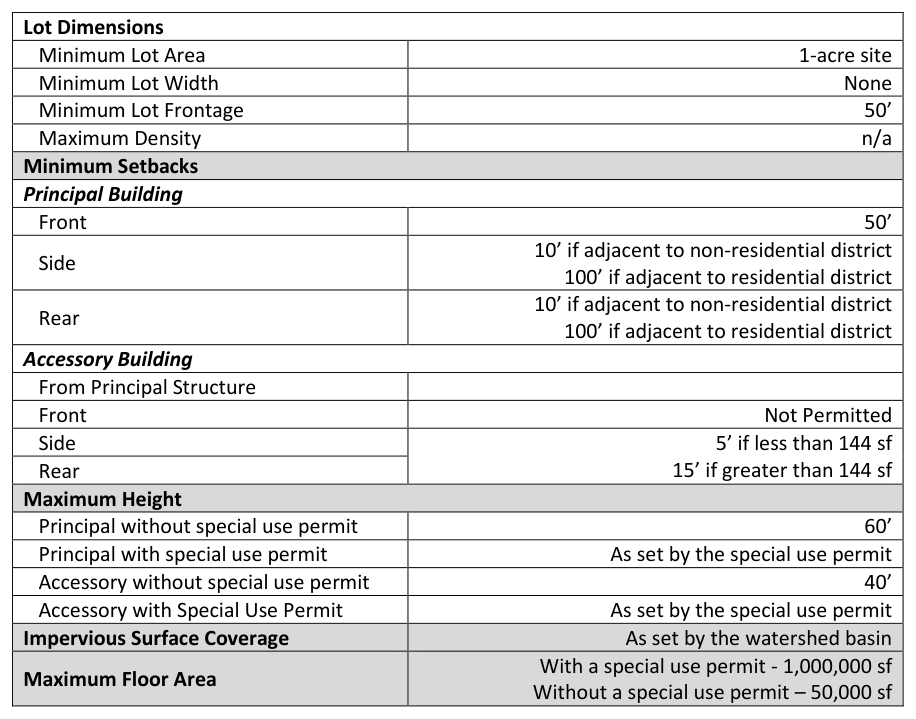
A.Purpose The IL light industrial district is established to protect and promote a suitable environment for light industrial purposes, including accessibility to major transportation facilities, availability of adequate utilities and other public services, and availability of large quantities of suitable land. Uses compatible with light industrial development are to be encouraged insofar as they are in accordance with the comprehensive plan for the city.
B.Lot Development Standards
Table 4.19-1
Table 4.19-1
Table shown as printed · verify at source (p. 36)

Accessory with Special Use Permit As set by the special use permit Impervious Surface Coverage As set by the watershed basin Maximum Floor Area With a special use permit - 1,000,000 sf Without a special use permit – 50,000 sf

C.Supplemental Regulations
1.Principle and Accessory use regulations shall be as established in Article 2, Use of Land and Structures and Article 3, Restrictions on Particular Uses.
D.Cross Reference Article 3 The references below are to sections of this Code that contain references specific to this zoning district.
1.Cross reference Article 3, Section 310 Standards for Office, Commercial and Industrial Uses
2.Cross reference Article 3, Section 313 Accessory Buildings, Uses and Structures.
3.Cross reference Article 3, section 331 for Gasoline Stations, Truck Stops, Heavy Truck Parking Facilities and convenience stores with fuel pumps
E.Cross Reference Article 4, Division V
1.Cross reference Article 4, Division V Section 4.28 for Minimum Lot Frontage requirements in general; Section 4.28(b) for Minimum Lot Frontage for large lots; and Section 4.28(d) for Street Frontage requirements.
2.Cross reference Article 4, Division V, Section 4.30 for Non-Residential Density and Lot Area Requirements.
3.Cross reference Article4, Division V, Section 4.31 for Minimum Lot Size requirements for septic tanks.
4.Cross reference Article 4, Division V, Section 4.32 (a-b) for Minimum Lot Width requirements.
5.Cross reference Article 4, Division V, Section 4.33 (a-b) for Minimum setback requirements for principle buildings.
6.Cross reference Article 4, Division V, Section 4.34 for Minimum setback requirements for accessory buildings.
7.Cross reference Article 4, Division V, Section 4.36 (a-b) for Maximum Building and Structure Height requirements.
8.Cross reference Article 4, Division V, Section 4.37 (a-e) for Solar Energy Equipment requirements.
9.Cross reference the Douglas County Standard Design Details Supplemental Appendix for additional information on lot design in the Light Industrial (LI) and Light Industrial Restricted (LI-
R)District.

.

§ 4.20

HI Heavy Industrial District

Sec. 4.20 HI Heavy Industrial District

A.Purpose The IH heavy industrial district is established to protect and promote a suitable environment for heavy industrial purposes, including accessibility to major transportation facilities, availability of adequate utilities and other public services and availability of large quantities of open land. Uses compatible with light and heavy industrial development are to be encouraged insofar as they are in accordance with the comprehensive plan for the city and are compatible with surrounding properties or the impact on surrounding properties can be sufficiently mitigated.
B.Lot Development Standards
Table 4.20-1
Lot Dimensions
Minimum Lot AreaInitial site 5 acres Internal development lots a minimum of 1-acre
Minimum Lot WidthNone
Minimum Lot Frontage50’
Maximum Densityn/a
Minimum Setbacks
Principal Building
Front50’
Side15’ if adjacent to non-residential district 100’ if adjacent to residential district
Rear15’ if adjacent to non-residential district 100’ if adjacent to residential district
Accessory Building
From Principal Structure
FrontNot Permitted
Side5’ if less than 144 sf 15’ if greater than 144 sf
Rear
Maximum Height
Principal without special use permit60’
Principal with special use permitAs set by the special use permit
Accessory without special use permit40’
Accessory with Special Use PermitAs set by the special use permit
Impervious Surface CoverageAs set by the watershed basin
Maximum Floor AreaWith a special use permit - 1,000,000 sf
Without a special use permit – 50,000 sf

Article 4, Division IV – Overlay Districts

Reading grid · rebuilt for display · verify at source (p. 38)
§ 4.21

General Provisions

Sec. 4.21 General Provisions As the name implies, overlay districts “over-lay” applicable base zoning district classifications to alter some or all of the base zoning district regulations that apply to particular sites. Overlay zoning districts work to modify or supplement the regulations imposed by base zoning district when necessary to address special situations or promote specific county planning goals. Overlay zoning is intended to be used when the base zoning district applied to an area remains generally appropriate, but when an additional, modified or eliminated requirement could help implement the county’s planning goals or address an area-specific planning, design or land use regulation issue. Certain districts are established as overlay districts, meaning that the "base" (or underlying) zoning district remains in place but the overlay adds additional provisions that override specific provisions of the base zoning district. The purpose of each of the overlay districts established in this Development Code is presented in this Section. All applicable regulations of the underlying base zoning district and of this Development Code apply to property in an overlay district unless otherwise expressly stated in the overlay district regulations. When overlay district regulations conflict with regulations that otherwise apply in the underlying base zoning district or with regulations otherwise imposed by this Development Code, the more restrictive regulations govern.

§ 4.22

Reserved

Sec. 4.22 Reserved Sec 4.21(a) O-HC Highway Corridor Overlay

(1)Intent The O-HC Highway Corridor Overlay district is intended to accommodate and promote high- quality, well-designed development that is in keeping with the existing and desired character of the county’s major highway corridor areas. The overlay is further intended to ensure consistency with the Douglas County comprehensive plan and with other adopted plans and policies of the county.
(2)Boundaries and Application
a.The boundaries of the O-HC district are as shown on the county’s official zoning map.
b.This Article shall apply to all non-residential development, all multi-family developments and residential subdivisions. Single-family detached dwellings constructed on a legal lot of record are exempt from the requirements of this Section 4.23.
(3)Uses Uses are allowed in O-HC district in accordance with the regulations of Sec. 210.
(4)Transportation and Access
a.Driveways and Access
1.All driveways with direct access onto to state highways, federal highways, or arterial roads must be designed to allow only right-in/right-out turning movements.
2.The driveway access regulations of Sec. 607(d) apply to all land uses within the O- HC district.
b.Inter-parcel Access The inter-parcel access regulations of Sec. 608 apply to all land uses within the O-HC district, except single-family residential.
c.Blocks
1.All development on parcels with an area of 3 acres or more must be organized into blocks with a maximum length of no more than 600 feet and a maximum perimeter of no more than 1,600 feet.
2.The resulting block systems must be used to organize internal site driveways and parking lots and provide access to abutting parcels. If the abutting parcels are undeveloped, stub-outs are required for future street connections.
(5)Streetscape A streetscape zone with a minimum depth of 40 feet is required along highway and arterial road frontages. The depth of the streetscape zone is measured from the right of way. Required streetscape zones must include the following features:
a.Fence A three-rail fence or approved enhanced landscape strip to provide screening is required within the streetscape zone. The fence must be located at least 20 feet from the right of way a distance as determined by the Director to ensure it is appropriate to the context of adjacent streetscape features and removed off of the right of way. The fence shall be white in color with brick supporting columns. Landscape screening must be approved by the County Arborist prior to installation.
b.Sidewalk Sidewalks with a minimum width of 5 feet are required within the required streetscape zone and may be located within the right of way upon approval by the jurisdiction. Sidewalks may be located on either side of the fence to provide flexibility in continuation and continuity with existing sidewalk installations on adjoining property along the road frontage.
c.Street Trees and Landscaping
1.A double row of overstory trees must be provided within the required streetscape zone.

Trees must be spaced no more than 40 feet on center.

2.Required overstory trees must have a minimum caliper size of 4 inches at time of planting and may be located on either side of the required sidewalk.
3.Should a project utilize an enhanced landscape screening in lieu of a three-rail fence, the landscape strip shall include the double-row of overstory trees identified above, as well as a minimum of 3 understory trees, 2 evergreen trees, and 18 shrubs per every 100 linear feet of landscape strip.
4.All landscaping must be located at a distance as determined by the Director to ensure it is removed off of the right of way.
d.Pedestrian Lighting Pedestrian-scaled lighting must be placed every 40 feet on center along one side of the sidewalk within the streetscape zone.
(6)Building Siting The setback regulations of the underlying zoning district apply in the O-HC district
(7)Building Design
a.Building Facades The building façade regulations of Table 4.23-2 apply to street-facing building facades on
Table 4.23-2: Building Facades
Minimum Ground Story Facade Transparency (%)
Front Street Façade (by building type/occupancy)
Multi-unit Residential, Office or industrial20
Retail, Entertainment, or Commercial Service35
Side Street Facades (by building type/occupancy)
Multi-unit Residential, Office or industrial20
Retail, Entertainment, or Commercial Service25
Minimum Upper-Story Facade Transparency
Front Street Façade15
Side street Façade15
Maximum Upper-Story Blank Wall Width (feet)20
Street-facing Building Entrances
Front StreetRequired
Side StreetNot Required
Maximum Distance Between Required Entrances (feet)175
Building Material Coverage Street Face (%) See 4.23(7)e
Traditional Masonry (Minimum)80
Building Material Coverage Side/Rear Face (%)
Traditional Masonry (Minimum)30
Synthetic Stucco (Ground-Story Maximum)60
Synthetic Stucco (Upper-Story Maximum)75
Building Mass Variation (based on building width)
50−200 Feet Building WidthNot Required
Over 200 Feet Building WidthRequired
Façade Articulation (based on building width)
50−200 Feet Building WidthNot Required
Over 200 Feet Building WidthRequired
Roof Forms
Allowed TypesPitched, Flat, Parapet

arterial roads

1.The Board of Commissioners may approve deviations from the standards contained in this section for new construction in the Highway Corridor Overlay as a special use upon a finding that all of the following are met:
a.Such deviation shall provide an adequate balance between the protection of the health, safety and welfare of the general public and the right to unfettered use of private property; and,
b.Such deviation shall foster beneficial development of the County in the public interest.
b.Building Materials Building material regulations are intended to help ensure that a building’s facade design reflects the county’s character by incorporating traditional and locally available materials.

Material coverage is calculated as the total street-facing facade area clad in the required or regulated material divided by the total street-facing facade area.

1.Traditional Masonry Traditional Masonry building materials include stone and brick. The planning and zoning manager is authorized to approve substitutes for traditional masonry.

Examples of alternative materials that can be approved include:

a)Wood;
b)Traditional Stucco on lathe;
c)Patterned pre-cast concrete;
d)Detailed concrete;
e)Cast stone;
f)Prefabricated brick panels;
g)Architectural concrete (textured or patterned); and
h)Fiber cement siding
2.Synthetic Stucco Synthetic Stucco includes External Insulation and Finish System (EIFS) and similar synthetic materials.
c.Building Mass Variation
1.Requirements for variations in building mass are intended to help lend visual interest and human scale to large, monotonous building facades through the use of design features that break a large building mass into different, clearly identifiable elements. Building mass variation requirements apply only to street-facing building facades that exceed 100 feet in length.
d.Facade Articulation
1.Façade articulation requirements are intended to help lend visual interest and a human-scale to otherwise flat and monotonous building facades through the use of design features that “break up” street-facing building facades into smaller visual components.
e.Roofs All major components of all principal building roofs must meet the requirements for a permitted roof type. Descriptions of roof types are as follows:
f.Pitched Roof Permitted pitched roof types include only hipped, gabled, and combination hip/gabled.

Such roofs must have a minimum 4:12 pitch. Eaves with a minimum depth of 12 inches are required on all pitched roofs. Roofing materials are limited to the following:

1.Metal standing seam;
2.Tile, slate, or stone;
3.Wood shake shingles; or
4.Shingles with a slate, tile, or metal appearance.
(8)Signs The sign regulations of Article 7 apply in the O-HC district except as expressly modified by the sign regulations of this subsection.
1.Design and Construction
a)The base and all vertical supporting elements of ground signs must be constructed of brick, stone, or stucco materials to match or compliment the principal building on the site.
b)Signs must have a uniform background, lettering style and color.
(9)Utilities All utility lines must be placed underground, unless the requirement is waived by the County Engineer due to physical construction constraints.

All lighting for commercial development shall be designed to integrate with the overall development character.

a)Lighting shall be architecturally integrated with the style, material and color of on-site structures.
b)Lighting shall be unobtrusive and refrain from adverse impact of adjacent properties and public rights-of-way.
c)Exposed neon and fluorescent lighting is not permitted except for open and closed signs.
d)For drive-under canopies and pump islands, the luminaries shall be recessed into the canopy ceiling so that that bottom of the luminaries does not extend below the ceiling buffers and setbacks.
(10)Buffers The intent of buffers is to provide a year-round visual screen such as evergreen trees between adjacent properties and the new development. All buffers and setbacks shall be as required by this ordinance. Any application for a design plan approval submitted to the Planning & Zoning Director or his/her designee shall include a tree survey and landscape plan, with buffers, prepared by a landscape architect.

Sec 4.21 (b) O-QGD Quality Growth Development Overlay.

The O-QGD Quality Growth Development Overlay District is established to promote high-quality development in areas of the county that are largely undeveloped but in the path of rapid, substantial residential, commercial, or industrial development that is anticipated will radically change the character of the lands within the District boundaries. This District is designed to encourage high-quality development by establishing restrictions and standards to protect the natural environment, promote optimum development, and so that investment values will be maximized and will not be endangered by unsightly, undesirable, or incompatible development on adjacent properties in the foreseeable future.

(1)Applicability The O-QGD regulations of this section (Sec. 4.24) apply to all multi-family residential, commercial, office, office distribution or industrial uses within the Quality Growth Development overlay.
(2)Intent.

The primary goals of the O-QGD overlay district are to provide a positive climate for high-quality investment and development, to provide a sense of place and orientation, to provide an attractive and functional environment, to ensure a harmony of uses and development, and to provide a comfortable, secure, and harmonious developed environment.

(3)Site design requirements.
a.Landscaping.
i.Generally.

Any multi-family residential, commercial, office, office distribution, or industrial use within the O-QGD shall comply with the landscaping requirements of this section in addition to the applicable requirements and standards of Article 2, Article 8 and Article 9.

ii.Landscaping requirements.

The location and detail of all required landscaping shall be depicted on the site landscaping plan (see the Procedures and Permits Article of this Development Code).

Minimum required landscaped area.

Each site shall have a minimum landscaped area of 25 percent. The calculated landscaped area may include tree islands within required parking areas.

Frontage landscape strip.

A minimum 25-foot wide landscape strip adjacent to the street right-of way shall be provided in such a way so as to achieve maximum screening effect, which may include installation at the road elevation or higher, based on the discretion of the Director.

Every 100 feet of linear landscape strip must include a minimum of 3 canopy trees, 3 understory trees, 2 evergreen trees, and 18 shrubs. Planting standards may be reduced up to 50% with the provision of a 5 feet tall earthen berm running the entire length of the landscape strip.

Side and rear yard landscaping.

Unless otherwise required in Article 8 of the Unified Development Code, all required side and rear yards shall be landscaped in accordance with the requirements of this article.

Other landscape areas.

All land surfaces other than those covered by permitted buildings, structures, paving, or other required site elements shall be landscaped with well-maintained grass, flowers, shrubs, or other suitable plant materials.

Natural buffers.

Natural buffers shall be supplemented with native plantings when existing vegetation on the site does not provide a minimum of 80% opacity between the proposed use and the adjacent residential district. These plantings shall include a mixture of canopy trees (50% must be evergreen), understory trees, evergreen coniferous trees and shrubs.

Canopy trees shall be no less than 3 inches in caliper and no less than 15 feet in height at the time of planting with a mature height of no less than 25 feet.

b.Screening.
i.Generally.

Any multi-family residential, commercial, office, office distribution, or industrial use within the O-QGD shall comply with the screening requirements of this section in addition to all other applicable requirements and standards of this Development Code.

ii.Requirements for loading areas, service equipment, outdoor storage areas.

All loading areas, outdoor service equipment, and outdoor storage areas, including those for trucks, busses, automobiles stored more than 48 hours, or the storage of any other vehicles or equipment shall be screened from street or adjacent property view by an attractive solid masonry wall finished on the exterior side by the same material used for the façade of the building. Such wall shall be not less than 5 feet in height and no more than 8 feet in height.

Specific height, as dictated by all applicable ordinance provisions, shall be determined during the site plan review process. If loading areas, service equipment or outdoor storage areas are not adjacent to residential zoning or visible from a public right-of-way, the Director may allow for reduction or elimination of these screening requirements.

iii.Exceptions for loading areas, service equipment and outdoor storage areas.

No screening is required to separate adjacent uses that are the same or similar.

A natural or structural buffer may be substituted for up to 25 percent of the required screening.

iv.Building landscaping and screening.

If a building structure faces a public street or is directly adjacent to a residentially zoned property, and has less than 25% glazing or openings (doors, windows, and service entries) on the façade facing the public street or residentially zoned property, a landscape screen shall be provided between the building structure and the residentially zoned lot in addition to any buffers required by Article 8 of this Development Code. Such screen must be a minimum of 15 feet in width and run the entire length of the subject building façade except where there are breaks for building access. Every 100 feet of linear building landscaping screen must include: 6 canopy trees (3 of which must be evergreen), 2 understory trees, 3 evergreen coniferous trees, and 18 shrubs. Canopy trees shall be no less than 3 inches in caliper and no less than 15 feet in height at the time of planting with a mature height of no less than 25 feet. Understory trees shall be deciduous or evergreen trees that typically grow to a mature height of less than 40 feet. The Director may allow for reduction or elimination of this requirement for building landscaping and screening if determined the requirement to be unfeasible based on specific conditions of the property.

c.Utility and service equipment.
i.All industry standard grade utilities shall be located underground. All entry fixtures and other service equipment shall be located in the side or rear yards outside of high use or high visibility areas. These fixtures shall be adequately screened by masonry walls, imitation- wood vinyl or composite material privacy fences with plantings, or plantings. Such fixtures and service equipment shall be screened in accordance with Article 8 screening requirements.
ii.All service equipment including but not limited to air conditioning units and other utility or mechanical equipment that will be located on a rooftop shall be screened from ground level view behind a parapet wall or other architectural extension, equal in height to the unit requiring screening. Such parapet or extension shall be compatible to, in design, and integrated architecturally to the building. A parapet or extension of up to 8 feet in height will not be included when calculating building height. Ground level view shall be defined as any view of the structure from the property line in any front yard of the property.
d.Outdoor storage.
i.Outdoor storage of merchandise or inventory (other than motor vehicles) may be permitted as outlined in Sec. 305 regarding outdoor storage. Such outdoor storage shall be screened as per Article 8 screening requirements.
ii.Outdoor storage of motor vehicles may be permitted only in paved areas shown on the site plan.
e.Sign regulations.
i.Number and size.

The sign regulations of Article 7 in regard to the number and size of signs apply in the QGO district as determined by the appropriate base zoning district.

ii.Materials.

All signs shall be composed of wood, stone or other similar materials.

f.Decorative fences & walls.
iii.Materials permitted.

Any fences or walls not required for screening under this section shall be composed of stone, decorative metal or decorative block. If located parallel to a street and within 30 feet of that street, these fences or walls shall comply with Article 8 of this Development Code.

iv.Prohibited materials; exception.

Chain link, unfinished concrete or cinderblock, plastic or fiberglass, barbed or razor wire, and wood fences are prohibited. Paint shall not be used as a finish material. Exceptionally, the above prohibited materials may be utilized on a security fence if located inside an approved screening fence, wall, or other screening element as specified above.

(4)Building design requirements.
a.Bulk & setback requirements.
1.Maximum building coverage.

Except for one-story warehouse, storage, or distribution buildings which are limited to a maximum building coverage ratio of 45 percent, the ratio of building coverage to the total lot area shall in no case exceed a ratio of 55 percent, unless otherwise approved by the Director.

2.Floor area ratio.

The ratio of total floor area of all buildings on a lot to the total site area (Floor Area Ratio) shall not exceed a ratio of 150 percent (or 1.5 times the total site area), unless otherwise approved by the Director.

b.Building finishes, wall planes and roof planes.
1.Wall planes and roof planes.

Any building facing a public street or directly adjacent to a residentially zoned lot shall not have wall planes exceeding 30 feet in length without a change in plane by means such as a vertical recess, projection, change in material or color or pilaster. Changes in roof planes shall occur at locations with changes in wall planes.

2.Prohibited finish materials.

Aluminum, steel, vinyl, mirrored or reflective glass, raw cinderblock, unfinished concrete, fiberglass or plastic are prohibited, except as architectural detailing and decorative trim of not more than 15% of any one façade, unless greater percentage is approved by the Director.

3.Permitted finish materials for front-facing facades.
a)Principal materials.

Exterior finish materials visible from any public street shall be any of the following:

i.Brick or brick face;
ii.Natural stone including granite, marble, sandstone, field stone or any other natural stone;
iii.Manufactured stone including imitation field stone, marble, terrazzo, and any other manufactured architectural finish stone;
iv.Clay tile with baked-on enamel finish; or architecturally treated decorative concrete block; or
v.Cementitious stucco wall siding (troweled, blown, board or plank), including limestone either troweled or blown and stamped, stained or textured in finish, Exterior Insulation and Finish Systems (EIFS).
vi.Metal siding is prohibited
b)Windows and glass doors.
i.At least 25% of the street-façade of all nonresidential buildings shall consist of:

glass windows and glass doors on each floor visible from a public street unless directly screened by an adjacent building landscaping screen, unless otherwise approved by the Director.

ii.At least 25% of the street-façade of all residential buildings shall consist of glass windows and glass doors on each floor visible from a public street unless directly screened by an adjacent building landscaping screen, unless otherwise approved by the Director.
4.Permitted finish materials for side and rear facades.

Exterior finish materials for side and rear facades shall be any of the following:

a)Brick or brick face;

Natural stone including granite, marble, sandstone, field stone or any other natural stone;

Manufactured stone including imitation field stone, marble terrazzo, and any other manufactured architectural finish stone;

Clay tile with baked-on enamel finish;

Architecturally treated decorative concrete block;

Architecturally treated slabs or block either fluted or with exposed aggregate;

Stucco on lathe or a synthetic stucco material (including EIFS) or an acceptable substitute.

Fiber cement/cementitious siding (board or plank).

(5)Other requirements.
a.Buildings and site elements shall be well maintained and repaired or replaced in a timely manner should damage or deterioration occur. Any damage or deterioration shall be corrected within 60 days.
b.Outdoor loudspeaker systems are prohibited.
c.For lots which include required landscaped yards, setbacks, buffer, or screens, the developer shall submit a maintenance plan as part of project approval, showing proper maintenance and irrigation of landscaped areas, and providing for dead and underperforming plant material to be removed and appropriately replaced.

Sec 4.21(c) Mixed-use master planned developments.

(a)Legacy Status
(1)No applications to establish new mixed-use master planned developments or to expand the boundaries of existing mixed- use master planned developments shall be accepted for processing after December 5, 2020, except that any special use application for a mixed-use master planned development that is in process on December 5, 2020 shall continue to be processed and may be approved.
(2)The special use approval, concept plan, and development plan text govern the use and development of existing, approved mixed-use master planned developments. Amendments to existing mixed-use master planned developments require an amendment of the concept plan and development text by the Board of Commissioners following the special use approval procedures of this UDC.

Sec 4.21(d) Master planned developments.

(a)Legacy Status
(1)No applications to establish new master planned developments or to expand the boundaries of existing master planned developments shall be accepted for processing after December 5, 2020, except that any special use application for a master planned development that is in process on December 5, 2020 shall continue to be processed and may be approved.

Sec 4.21(e) O-ED Estate Density Overlay District.

The O-ED overlay district is established to protect and promote a suitable environment for rural or "large lot suburban" family life, agriculture including the raising of livestock and poultry, and the development of natural resources and other uses requiring extensive areas of land. This overlay district is required to protect the future development of land in accordance with the comprehensive plan of the county as amended. The O-ED overlay district shall place the following restrictions in addition to those in the overlaid districts. The minimum lot size and density requirements of this overlay district shall be met unless greater area is required for a use by the zoning district in which the property is located.

(1)Permitted uses.

All permitted uses that are allowed by this Development Code on a property by the applicable base zoning district are permitted provided they do not conflict with any requirement of this Section.

(2)District location.

The O-ED Overlay District is described as all those portions of Land Lots 1 through 6, 31 through 37, 39, 40 and 63 of the 1st District, 5th Section; Land Lots 1 through 3 and 32 of the 2nd District, 5th Section; and Land Lots 1 through 5, 7 through 13, and 23 of the 3rd District, 5th Section of Douglas County that are within the Bear Creek Watershed Protection District as defined on the Official Zoning Map of Douglas County. This area shall exclude parcel numbers 0006-015-0001, 0006-015-0006, 0006-015-0007, 0006-015-0008, 0006-015-0010, 0007-015-0002, 0007-015-0002, 0040-015-0016, 0041-015-0001 located on the official tax map of Douglas County.

The O-ED Overlay District is further described as all those portions of Land Lots 148 through 152; 165, 166, 170 through 172, 181 through 184, 187 through 189, 195 through 198, 200 through 207, 210 through 222, 226 through 239, 242 through 248 of the 2nd District, 5th Section; and Land Lots 562 through 565, 623 through 629, 644 through 657, 680 through 696, 711 through 730 of the 1st District 3rd Section as defined on the Official Zoning Map of Douglas County.

(3)Area requirements:

The following requirements shall be met before any permits will be issued. When these requirements conflict with those in the R-A and R-LD zoning districts, as applicable to a particular property, the more restrictive shall apply.

a.Minimum lot size, single-family dwellings.

A single-family dwelling shall comply with the following minimum density and lot size requirements:

1.Every lot or subdivision shall achieve an overall density of one dwelling unit per no less than three acres (130,680 square feet) of gross land area.
2.A dwelling unit may be located on a lot containing no less than 43,560 square feet (one acre) of net land area, provided that the minimum density requirement of one dwelling unit per three acres is met for all dwelling units on the property or in the subdivision as a whole.
3.Deviations from the minimum density and lot size requirements of this Subsection may be granted by the Board of Commissioners in cases deemed to constitute a hardship to the property owner or an extraordinary benefit to the public health, safety or general welfare. Deviations shall be considered by the Board of Commissioners upon application of the property owner and following all procedures in conformance with the Procedures and Permits Article of this Development Code as though a zoning map amendment. No deviations will be considered for any financial hardship requests.
Deviations may be granted as follows:
a)As a condition of approval imposed at the time of rezoning of a property; or
b)Upon appeal to the Board of Commissioners by the property owner.
b.Minimum lot size, other uses.

Any use other than a single-family dwelling shall occupy a property containing no less than 3 acres (130,680 square feet) of gross lot area.

c.Minimum buildable lot area.
1.Every property shall provide a single, contiguous buildable area of at least 43,560 square feet (one acre) within the lot exclusive of any land contained within a primary conservation area as defined in the Environmental Protection Article of this Development Code.
2.Additional land contained within a property or subdivision in excess of the minimum buildable area for each lot may be located within a primary conservation area.
(4)Treatment of open space.

Land within a subdivision that is not included within individual building lots shall be set aside as common open space. Such open space and primary and secondary conservation areas shall comply with the following provisions:

a.Conservation areas.

All primary conservation areas, and all secondary conservation areas designated by the developer for protection, shall be included within a conservation or natural resource easement (as applicable) in accordance with the requirements for such easements contained in the Environmental Protection Article of this Development Code

b.Ownership.

All common open space shall be owned by a homeowners' association in accordance with the requirements for such property owners' associations under the Subdivisions and Planned Developments Article of this Development Code.

Sec 4.21(f) O-LF Landfill Overlay.

The O-LF Landfill Overlay District is established in order to protect properties near existing or previously closed solid waste disposal facility from well-water contamination and from the buildup of methane gas within enclosed buildings. It is the intent of this overlay district to maintain compliance with requirements imposed by the Georgia Department of Natural Resources, Environmental Protection Division (Chapter 391-3-4, Solid Waste Management).

(1)Area included.

The O-LF district is hereby established to include all areas located within ½-mile (2,640 feet) of the property line of a property on which is located a solid waste disposal facility permitted under the rules of the Georgia Environmental Protection Division, whether currently active or previously closed.

(2)Restrictions.
Within the O-LF district, the following shall apply:
a.No new potable wells shall be allowed.
b.Within 500 feet of the property line of a property on which is located a currently active or previously closed solid waste disposal facility, no new enclosed structures of any kind shall be permitted or constructed.
(3)Relief.

Relief from the restrictions imposed by the O-LF Landfill Overlay District may be requested under the Appeals Article of this Development Code.

Sec 4.21(g) Airport Hazard Overlay District The O-AH Airport Hazard Overlay District provides restrictions that supplement or override provisions of the underlying zoning districts beneath the airport zone, and includes all areas shown on the map labeled as such and adopted as part of the Official Zoning Map as required by Federal Aviation Regulations (FAR) Part 77.

(1)Definitions related to airport zones.

Airfield: In this section the terms "airfield" and "airport" are interchangeable and mean airfields in Douglas County.

Approach-departure clearance surface: This surface is symmetrical about the runway centerline extended. It begins as an inclined plane (glide angle) two hundred (200) feet beyond the end of the runway at the same elevation as the runway end, and extends for 50,000 feet. The slope of this surface is fifty to one (50:1) (glide angle) for military airports, along the runway centerline extended for 25,000 feet, at which point it reaches an elevation of 500 feet above the elevation of the runway end. It then continues horizontally at this elevation for an additional 25,000 feet. The width of this surface at the starting point (200 feet from the runway end) is 2,000 feet. It flares uniformly and the width at 2.5 miles is 2,696 feet. Glide angles for other types of airports shall be determined by consultation with the county engineer.

Flight hazard: Any structure or natural growth or use of land that obstructs or restricts the airspace required for the safe flight of aircraft in landing, takeoff or maneuvering areas as or in the vicinity of the airfield.

Landing area: That part of the airfield that is used or intended to be used for landing and takeoff of aircraft.

Structure: An object, including a mobile object, constructed or installed by man, including, but without limitation, buildings, towers, cranes, smokestacks, earth formations and overhead transmission lines.

(2)Compatible use zones.

To carry out the purposes of this section, all of the land within the boundaries of the future airfields in Douglas County and within one mile of the runway centerline extended of each instrument runway affected, for a distance of 2.5 miles from each end of such runway, is hereby declared to be a compatible use zone (CUZ) divided into three sub zones. The sub zones are:

(a)CUZ-1: From the end of the runway extending outward in fan-shaped fashion matching the horizontal dimension of the approach-departure clearance surface for a distance of 2,500 feet.
(b)CUZ-2: From the end of CUZ-I to a point 2.5 miles from the end of the runway, extending in fan-shaped fashion to match the horizontal dimension of the approach-departure clearance surface.
(c)CUZ-3: All of the CUZ not included in CUZ-1 and CUZ-2.
(3)Height limitations.

Except as otherwise provided in this section, no structure or natural growth shall be erected, altered, allowed to grow or maintained in the CUZ to a height in excess of the height specified below for each sub zone.

(a)CUZ-1 and CUZ-2: Height limit is 10 feet below the approach-departure clearance surface with a maximum height of 50 feet.
(b)CUZ-3: Height limit is 150 feet for this entire zone except for the area 2,050 feet on both sides of and parallel to the runway centerline which is governed by the seven to one (7:1) transitional slope surface.
(4)Land use restrictions.

No use may be made of land or water within the Airport Hazard Overlay District in such a manner as to create electrical interference with navigational signals or radio communication between the airport and aircraft, make it difficult for pilots to distinguish between airport lights and others, result in glare in the eyes of the pilots using the airport, impair visibility in the vicinity of the airport, create bird strike hazards, or otherwise in any way endanger or interfere with the landing, takeoff, or maneuvering of aircraft intending to use the airport.

(5)Regulations not retroactive.

The limitations prescribed in this Section shall not be construed to require the removal, lowering, or other change or alteration of any structure or natural growth not conforming to the regulations of this Division as of the effective date hereof, or otherwise interfere with the continuance of any nonconforming use. Nothing contained in this Division shall require any change in the construction, alteration or intended use of any structure, the construction or alteration of which has begun prior to the effective date of this Development Code and is diligently prosecuted and completed within two years thereof.

(6)Variance request.

Any person desiring to erect any structure or increase the height of any structure, or permit natural growth, or use such person's property, not in accordance with the regulations prescribed in this Division, may apply for a hardship variance under the provisions of the Procedures and Permits Article of this Code. Such variance may be allowed where a literal application or enforcement of the regulations would result in practical difficulty or unnecessary hardship and the relief granted would not be contrary to the public interest, but do substantial justice and be in accordance with the spirit of this section.

(7)Obstruction marking and lighting.

Any variance granted under Section 4.30 (f), if such action is considered advisable to effectuate the purposes of this Division and reasonable in the circumstances, may be so conditioned as to require the owner of the structure or natural growth in question to permit the airport operator at the owner's expense to install, operate and maintain thereon such markers and lights as may be necessary to indicate to airport pilots the presence of a flight hazard.

(8)FAA approval.

Included in any application for approval of an Airport Hazard Overlay District or for a variance under Sec.

4.21(g) there must be written approval by the Federal Aviation Administration that the property in question will be suitable for development as an airport or that the variance will not be inconsistent with FAA rules and regulations.

Section 4.21(h) Westfork and Thornton South Overlay

1.Purpose and Intent: The purpose of the Westfork & Thornton South Overlay is to promote the health, safety, morality, aesthetics, and general welfare of the community by supplementing the original Planned Unit Development (PUD) designation of the Westfork Development in proximity to Thornton Road. This overlay includes provisions:
a.To honor the original intent of the 1973 Westfork Overall Regulating Plan and subsequent amendments.
b.To update the original intent in light of changing infrastructure, economic, and regional circumstances.
c.To facilitate the use of the existing structures at a scale and design suitable in the context of changing conditions.
d.To account for the transition of property or uses with the implementation of appropriate thresholds for redevelopment.
e.To account for definitions of permitted and prohibited uses.
f.To maintain the economic viability of uses along the Thornton Rd corridor.
g.To provide safe multi-modal options for pedestrian, bicycle, transit, and motor vehicle transportation.
h.To ensure development of long-term, viable greenspace.
i.To maintain a sense of place through implementation of coherent and cohesive aesthetic design standards based on the existing and original character of Westfork and Thornton Road.
j.To provide for the safety of all businesses, residences, and visitors to the Westfork and Thornton Road community.
2.Boundary and Applicability:
a.The boundary of the Westfork & Thornton South Highway Corridor Overlay shall be known as the “Westfork Overlay” and is shown on Douglas County’s official zoning map.
b.This Section shall apply to all nonresidential, multi-family, and residential subdivisions within the boundary as delineated in the official Douglas County zoning map regardless of parcel lot split, reconfiguration, or combination subsequent to its enactment.
c.The Westfork and Thornton South Overlay is divided into Sub-Areas for the purpose of implementing specific regulations. A Sub-Area is an area with a defined name, boundary, permitted uses, prohibited uses, architectural standards, and landscape standards. See the Westfork Overall Regulating Plan for category and number of sub-use area(s).
a.The Westfork PUD is a Planned Unit Development approved in 1973 and subsequently amended. The Westfork Development Plan defined sub-areas of the Westfork Business Park to be “M” for “Industrial,” “C” for “Commercial,” and “H” for Residential.
3.Interpretation of Sub-areas and Allowable Uses: The terms defined herein describe the sub-areas within the bounds of the Westfork & Thornton South Overlay.
a.Commercial & Professional: This sub-area is established to provide for those uses that are characterized by occupancy of small footprint (5,000 +/- sq. ft.) suites within a larger structure and are retail- or service-oriented, professional- or trade-specific uses.
i.The permitted uses within this sub-area will be those permitted in the OI, Office-Institutional, and C-G, General Commercial, zoning districts subject to any additional restrictions as specified per Article 2, Section 210(f), Tables 2.2 & 2.3 of the Unified Development Code of Douglas County.
ii.Uses permitted in the C-H, Heavy Commercial, zoning district per Article 2, Section 210(f), Tables 2.2 & 2.3 of the Unified Development Code of Douglas County will be permitted with Special Use Permit approval only subject to any additional restrictions as specified in Article 2, Section 210(f), Tables 2.2 & 2.3 of the Unified Development Code of Douglas County.
b.Professional, Warehousing, and Distribution Flex: This sub-area is established to provide for those uses that are characterized by occupancy of medium-to-large-footprint (greater than 10,000 sq. ft.) suites within a larger structure and are service-oriented, professional- or trade-specific, or light manufacturing and warehousing uses.
i.The permitted uses within this sub-area will be those permitted in the OI, Office-Institutional, C-G, General Commercial, and C-H, Heavy Commercial, zoning districts subject to any additional restrictions as specified per Article 2, Section 210(f), Tables 2.2 & 2.3 of the Unified Development Code of Douglas County.
ii.Uses permitted in the LI, Light Industrial, zoning district per Article 2, Section 210(f), Tables 2.2 & 2.3 of the Unified Development Code of Douglas County will be permitted with Special Use Permit approval only subject to any additional restriction as specified in Article 2, Section 210(f), Tables 2.2 & 2.3 of the Unified Development Code of Douglas County.
c.Greenspace: This sub-area is established to provide for those uses that are characterized as natural or passive open spaces. Flood plain is typical in this sub area.
i.The permitted uses within this sub-area will be those permitted in the PSP, Public, Semi-Public, zoning district subject to any additional restrictions as specified per Article 2, Section 210(f), Tables 2.2 & 2.3 of the Unified Development Code of Douglas County.
d.Heavy Commercial & Retail: This sub-area is established to provide for those uses that are characterized by a small-scale, heavy commercial character and are service-oriented, professional-, or retail-oriented uses.
i.The permitted uses within this sub-area will be those permitted in the OI, Office-Institutional, C-G, General Commercial, and C-H, Heavy Commercial, zoning districts subject to any additional restrictions as specified per Article 2, Section 210(f), Tables 2.2 & 2.3 of the Unified Development Code of Douglas County.
e.High-Density Residential: This sub-area is established to provide for those uses that are characterized by multi-family development.
i.The permitted uses within this sub-area will be those permitted under the R-HD, Residential, High-Density, zoning district per Article 2, Section 210(f), Tables 2.2 & 2.3 of the Unified Development Code of Douglas County.
f.Highway Commercial: This sub-area is established to provide for those uses that are characterized by occupancy of buildings that are either single-use or feature multiple, leasable suites. This area was largely developed subsequent to the original Westfork approval and was historically regulated through traditional commercial and professional base zoning categories.
i.The permitted uses within this sub-area will be those permitted under the C-G, General Commercial, and C-H, Heavy Commercial, zoning districts per Article 2, Section 210(f), Tables 2.2 & 2.3 of the Unified Development Code of Douglas County.
g.Manufacturing, Warehousing, and Distribution: This sub-area is established to align with the industrial development of the original 1973 Westfork vision. Building footprints are on average of 100,000 sq. ft. Most are occupied as single-tenant facilities and this characteristic should be preserved.
i.A special use permit is required to reduce suites below 50,000 sq. ft.
ii.The permitted uses within this sub-area will be those permitted under the LI, Light Industrial, and LI-R, Restricted Light Industrial, zoning districts per Article 2, Section 210(f), Tables 2.2 & 2.3 of the Unified Development Code of Douglas County.
4.New Development and Redevelopment, defined: New development and redevelopment in the Westfork and Thornton South Overlay shall be sensitive to the context of the established development within the boundary of the overlay.
a.Within the boundary of the original Westfork Planned Unit Development, redevelopment will constitute a change to any building’s size, shape, footprint, architectural finish, parking area, loading & unloading spaces, or any other aspect that would change the original intent of the 1973 PUD approval at a rate of total new improvements exceeding a threshold of 10% of the size of the existing footprint prior to the proposed change.
b.Any area within the overlay boundary that is excluded from the original Westfork Planned Unit Development, redevelopment will constitute a change to any building’s size, shape, footprint, architectural finish, parking area, loading & unloading spaces at a rate of total new improvements exceeding a threshold of 20% of the size of the existing footprint prior to the proposed change.
c.New construction exceeding a threshold of 50,000 sq. ft. shall be required to be reviewed by the Development Review Committee and obtain a Special Use Permit from the Board of Commissioners.
5.Streetscape Requirements: A landscape strip will be required upon new development, redevelopment, or expansion of existing development at specified thresholds along all arterial and local road frontages and shall comprise a depth of 20’ along all arterial road frontages and 10’ along all local road frontages.

Depth is measured from the right-of-way.

a.A streetscape zone with a minimum depth of 20’ shall be required along all arterial road frontages, and a streetscape zone with a minimum depth of 10’ shall be required along all local road frontages. When a streetscape zone is required, it shall include the following features:
i.Arterial Road Frontage:
1.The streetscape zone shall be a minimum depth of 20’.
2.The streetscape zone shall include 3 understory trees, 2 evergreen trees, and 18 shrubs every 100’ of linear strip.
3.Pedestrian-scaled lighting shall be provided and placed every 40 feet on center within the streetscape zone exterior to the required landscaping and abutting available right-of-way.
4.The Director of Development Services will have discretion to reduce the depth of or number of plantings within the streetscape zone by no more than 15% if it is determined that the existing conditions of the site, where accounting for ingress and egress, existing utility infrastructure, or length of road frontage, may be inhibitive to functionality if strict compliance were adhered.
ii.Local Road Frontage
1.The streetscape zone shall be a minimum depth of 10’.
2.The streetscape zone shall include understory trees at a rate of no less than 3 understory trees, 2 evergreen trees, and 18 shrubs every 100’ of linear strip.
3.The Director of Development Services will have discretion to reduce the depth of or number of plantings within the streetscape zone by no more than 15% if it is determined that the existing conditions of the site, where accounting for ingress and egress, existing utility infrastructure, or length of road frontage may be inhibitive to functionality if strict compliance were adhered.
6.Building Design:
a.General Guidelines - Building Façades for Residential and Non-Residential Development:
i.The building façade regulations of this overlay, unless required as regulation for a sub-area category, will defer to Appendix A of the Unified Development Code;

specifically, Section 1(C) for Residential and Section 2(B)(6-7) for Non-Residential shall govern. Alternative provisions may be provided at the discretion of the Director of Development Services if it is determined that the proposed elevations would be of a similar architectural style and finish to structures currently existing in the immediate vicinity along the street frontage of the proposed structure.

7.Signs:
a.General Guidelines:
i.The sign regulations of Article 7 apply in the Westfork and Thornton South Overlay District except as expressly modified by the sign regulations of this subsection:
1.Design and construction:
a.The base and all vertical supporting elements of ground signs must be constructed of brick, stone, or stucco materials to complement the character of the principal buildings within this overlay district.
b.Signs must have a uniform background, lettering style, and color.
2.Variance, where available:
a.Variances to sign size, height, and location shall be submitted and considered in accordance with Article 13 of the Unified Development Code.
8.Utilities:
a.All utility lines must be placed underground unless the requirement is waived by the Douglas County Engineer due to physical construction constraints.
b.All service equipment that is not roof-mounted shall be screened on three sides by a 6’

enclosure finished in a similar finish of the principal building.

i.If service equipment is roof-mounted, it shall be screened from ground-level view behind a parapet wall or architectural extension equal in height to the unit(s) to be screened. Such parapet or extension shall be compatible in design and integration with the architectural treatment of the building.
c.All heating and air-conditioning units shall be roof-mounted and concealed behind a parapet wall or architectural extension equal in height to the unit(s) to be screened. Such parapet or extension shall be compatible in design and integration with the architectural treatment of the building.
d.All site lighting shall conform to the standards set forth in Article 10, Section 1026 of the Unified Development Code.
9.Performance Standards:
a.Developers who apply the high-performance standards listed below are allowed up to a 50% modification in the Lot Development Standards as specified under the base zoning category which governs for each sub-area as dictated by the end-use case of the proposal. Utilizing these standards and receiving this grant of modification must be approved prior to any project commencement, and any alteration to these standards may result in revocation of the grant of modification. To achieve the full 50% grant of modification, each item below will be credited toward 10% of the total. To achieve 100% of the bonus, all standards must be satisfied.
i.Provision of at least one, protected bicycle parking space per 2,000 sq. ft. of gross floor area.
ii.Provision of at least one electric vehicle charging station per 50 parking spaces.
iii.Provision of pedestrian infrastructure to allow for inter-parcel connectivity between adjacent uses that are adequately landscaped and protected from vehicular traffic and circulation via installation of overstory or understory trees and, where not feasible, bollards.
iv.Provision of transit-oriented amenities providing access to community transit systems.
v.Installation of roof-mounted solar equipment in the amount that would yield a supplemental capacity to what is supplied via existing or proposed utility infrastructure. The amount proposed to be generated would have to be demonstrated to be appreciable when compared to the total amount of energy typical for a building of a similar size powered via traditional utility infrastructure.

Section 4.21(j) Central West Workplace Campus Overlay

(1)Intent. The intent of the Central West Overlay is to provide regulations to manage orderly growth and development in the Central West industrial node as identified on the Douglas County Zoning Map. The Central West Overlay applies to 800+ acres for a high-tech jobs center in a campus-like environment. Development of the Central West Overlay should occur in accordance with a master plan for access to roads, railroads, water, sewer, broadband and other utilities. The overlay is intended to support campus-like professional and technology-based industries rather than uses that will generate heavy truck traffic, excessive noise or nuisances which are discouraged in this district of the county. Preservation of the natural environment as an amenity to the development of the node is a key priority.
(2)Purpose
a)To build a strong local workforce and support skills attainment for current residents by providing additional educational programs and skills coaching to remove barriers to entry.
b)To connect local workforce employers to current residents and attract new residents to the county.
c)To develop, retain, and attract talent by improving workplace quality and accessibility.
d)To further support economic development opportunities in the county by attracting key employers.
e)To create balance between workplace demand and employee retention in Douglas County.
f)To create balance between economic development goals and the preservation of the natural environment and rural character.
g)To provide access to infrastructure for connectivity and longevity of new employment centers.
h)To leverage proximity to I-20 for connectivity and access among metropolitan Atlanta.
(3)Boundary. The Central West Overlay shall be as depicted on the Douglas County Zoning Map.
(4)Permit Required. Proposed development within the Central West Overlay must be evaluated for compatibility with the intent of the node. Development projects that are not compatible with the intent and purpose of the overlay will require a Special Use Permit from the Board of Commissioners. Any application for rezoning must be accompanied by a statement of jobs that will be created by the end use of the property. Additional criteria for consideration.
(5)Allowable Uses. Allowable uses shall be as outlined in Article 2, Section 210, Tables 2.2 and 2.3 of the Unified Development Code. Any use not otherwise allowed in this district shall be prohibited.
(6)Performance Standards
a)Odors. No odors shall be emitted that are detectable without instruments at or beyond any property line.
b)Noise. Every use shall be so operated as to comply with the noise limitations specified in Chapter 11, Article V, Noise Control, Code of Ordinances, Douglas County, Georgia, as amended or revised.
c)Vibration. Maximum permitted vibration from any cause shall not exceed the following, when measured at the lot line:

Frequency (Cycles per Second)

Displacement (Inches)

10 and below 0.0008 10—20 0.0005 20—30 0.0003 30—40 0.0002 40—50 0.0001 50 and above 0.0001

d)Light. No direct or reflected glare shall be produced so as to be visible at or beyond any lot line.
e)Air Pollution.
1)Every use shall be operated as to comply with Article 9 as amended or revised.
2)Subject to restrictions in Article 3 Section 357 (Noxious Manufacturing or Industrial activities not allowed)
f)Water Pollution.
1)Every use shall be operated as to comply with Article 9 as amended or revised.
2)Subject to restrictions in Article 3 Section 357 (Noxious Manufacturing or Industrial activities not allowed)
g)Fire and Explosion Hazard. All activities and all storage of flammable and explosive materials shall be disclosed to the Douglas County Fire Chief and shall be maintained in compliance with all local ordinances.
(7)Site Design Requirements
a)Overall Regulating Plan Required. All projects within the Central West Overlay shall be bound to an overall site regulating plan that is approved at the time of any zoning action.

Any change to the regulating plan not otherwise approved by the Director of Development Services shall be presented to the Douglas County Board of Commissioners as a zoning amendment to approve or deny in accordance with Article 12 of this Code.

b)Infrastructure Concurrency Requirements. Any new infrastructure required to serve the project must be installed before the issuance of building permits to serve the project, unless an administrative variance is otherwise obtained from the Director of Development Services. Improvements that may be required to serve multiple sites or parcels must be installed prior to certificate of occupancy of any future users.
c)Minimum Lot Size. The minimum lot size for non-residential development within the Central West Overlay is four (4) acres.
d)Maximum Building Coverage. The maximum allowable building coverage of a project within the Central West Overlay is forty percent (40%) of the total parcel acreage.
e)Maximum Impervious Surface Coverage. The maximum allowable impervious surface coverage of a project within the Central West Overlay is sixty percent (60%) of the total parcel acreage. This includes buildings, structures, parking areas or any other feature of the property that creates impervious surface.
f)Minimum Building Setbacks. Setbacks for any building or structure within the Central West Overlay shall be as follows, unless otherwise stipulated as a part of zoning approval of a regulating plan.
i.Front: 100 feet
ii.Side: 50 feet
iii.Rear: 50 feet
g)Landscaping.
i.Generally. Any multi-family residential, commercial, office, office distribution, or industrial use within the O-CW shall comply with the landscaping requirements of this section in addition to the applicable requirements and standards of Article 2, Article 8 and Article 9.
ii.Landscaping Requirements. The location and detail of all required landscaping shall be depicted on the site landscaping plan (see the Procedures and Permits Article of this Development Code).
iii.Minimum Landscaped Area. Each site shall have a minimum landscaped area of 25 percent. The calculated landscaped area may include tree islands within required parking areas.
iv.Frontage Landscape Strip. A minimum 25-foot wide landscape strip adjacent to the street right-of way shall be provided in such a way so as to achieve maximum screening effect, which may include installation at the road elevation or higher, based on the discretion of the Director. Every 100 feet of linear landscape strip must include a minimum of 3 canopy trees, 3 understory trees, 2 evergreen trees, and 18 shrubs. Planting standards may be reduced up to 50% with the provision of a 5 feet tall earthen berm running the entire length of the landscape strip.
v.Side and Rear Landscaping. Unless otherwise required in Article 8 of the Unified Development Code, all required side and rear yards shall be landscaped in accordance with the requirements of this article. All land surfaces other than those covered by permitted buildings, structures, paving, or other required site elements shall be landscaped with well-maintained grass, flowers, shrubs, or other suitable plant materials.
vi.Natural buffers. Natural buffers shall be supplemented with native plantings when existing vegetation on the site does not provide a minimum of 80% opacity between the proposed use and the adjacent residential district. These plantings shall include a mixture of canopy trees (50% must be evergreen), understory trees, evergreen coniferous trees and shrubs. Canopy trees shall be no less than 3 inches in caliper and no less than 15 feet in height at the time of planting with a mature height of no less than 25 feet.
h)Screening.
i.Generally. Any multi-family residential, commercial, office, office distribution, or industrial use within the O-QGD shall comply with the screening requirements of this section in addition to all other applicable requirements and standards of this Development Code.
ii.Requirements for loading areas, service equipment, outdoor storage areas. All loading areas, outdoor service equipment, and outdoor storage areas, including those for trucks, busses, automobiles stored more than 48 hours, or the storage of any other vehicles or equipment shall be screened from street or adjacent property view by an attractive solid masonry wall finished on the exterior side by the same material used for the façade of the building. Such wall shall be not less than 5 feet in height and no more than 8 feet in height. Specific height, as dictated by all applicable ordinance provisions, shall be determined during the site plan review process. If loading areas, service equipment or outdoor storage areas are not adjacent to residential zoning or visible from a public right-of-way, the Director may allow for reduction or elimination of these screening requirements.
iii.Exceptions for loading areas, service equipment and outdoor storage areas. No screening is required to separate adjacent uses that are the same or similar. A natural or structural buffer may be substituted for up to 25 percent of the required screening.
i)Utility and service equipment.
i.All industry standard grade utilities shall be located underground. All entry fixtures and other service equipment shall be located in the side or rear yards outside of high use or high visibility areas. These fixtures shall be adequately screened by masonry walls, imitation- wood vinyl or composite material privacy fences with plantings, or plantings. Such fixtures and service equipment shall be screened in accordance with Article 8 screening requirements.
ii.All service equipment including but not limited to air conditioning units and other utility or mechanical equipment that will be located on a rooftop shall be screened from ground level view behind a parapet wall or other architectural extension, equal in height to the unit requiring screening. Such parapet or extension shall be compatible to, in design, and integrated architecturally to the building. A parapet or extension of up to 8 feet in height will not be included when calculating building height. Ground level view shall be defined as any view of the structure from the property line in any front yard of the property.
j)Sign regulations. The sign regulations of Article 7 in regard to the number and size of signs apply in the O-CW district as determined by the appropriate base zoning district. All signs shall be composed of wood, stone or other similar materials.
k)Building design requirements.
i.Prohibited finish materials. Aluminum, steel, vinyl, mirrored or reflective glass, raw cinderblock, unfinished concrete, fiberglass or plastic are prohibited, except as architectural detailing and decorative trim of not more than 15% of any one façade, unless greater percentage is approved by the Director.
ii.Permitted finish materials for front-facing facades.
1.Principal materials. Exterior finish materials visible from any public street shall be any of the following:
a.Brick or brick face;
b.Natural stone including granite, marble, sandstone, field stone or any other natural stone;
c.Manufactured stone including imitation field stone, marble, terrazzo, and any other manufactured architectural finish stone;
d.Clay tile with baked-on enamel finish; or architecturally treated decorative concrete block; or
e.Cementitious stucco wall siding (troweled, blown, board or plank), including limestone either troweled or blown and stamped, stained or textured in finish, Exterior Insulation and Finish Systems (EIFS).
f.Metal siding is prohibited
2.Permitted finish materials for side and rear facades. Exterior finish materials for side and rear facades shall be any of the following:
a.Brick or brick face;
b.Natural stone including granite, marble, sandstone, field stone or any other natural stone;
c.Manufactured stone including imitation field stone, marble terrazzo, and any other manufactured architectural finish stone;
d.Clay tile with baked-on enamel finish;
e.Architecturally treated decorative concrete block;
f.Architecturally treated slabs or block either fluted or with exposed aggregate;
g.Stucco on lathe or a synthetic stucco material (including EIFS) or an acceptable substitute.
h.Fiber cement/cementitious siding (board or plank).

Section 4.21(k) Cedar Mountain Overlay

1)Intent. Cedar Mountain is an area of northwest Douglas County typified by a unique ecosystem.

It is comprised of geologic features that contribute to a habitat which sustains a rare botanical environment.

The predominant geologic unit underlying Cedar Mountain is Ropes Creek Metabasalt. Calcium-rich soils, such as those found over Ropes Creek Metabasalt support a disproportionately large number of rare plant species found within Georgia. Distinct rock outcroppings support unique and diverse assemblages of native plants, some of which are rare botanical species. Cedar Mountain also holds potential for the identification of rare and endangered animal species dependent on the unique ecosystem.

The Piedmont Mafic Dry-Oak Hickory Forest is threatened by forest conversion and habitat destruction. Evidence of pre-historic occupation and early settlement may contribute to understanding the early history of Douglas County. The topography changes of the wooded and granite outcrops, along with scenic long vistas, contribute to the unique sense of place in Douglas County.

It is the intent of this ordinance to identify appropriate measures to mitigate any land use or development that would potentially be a detriment to the natural, scenic or cultural environmental of this unique and valuable resource.

2)Purpose. The purpose of the Cedar Mountain Overlay is
a.To preserve ecosystems and habitats that would otherwise be vulnerable to developmental changes;
b.To promote the connectivity of greenspace and wildlife corridors;
c.To support recreational and educational opportunities for residents;
d.To create economic development opportunities through tourism and placemaking;
e.To preserve and protect water quality;
f.To maintain aesthetic value of greenspace, rural landscape, and signature characteristics of the county; and
g.To allow for development with scale and density that prioritizes ecosystem preservation.
3)Boundary. The boundary of the Cedar Mountain Overlay shall encompass all or portions of District 2 Section 5, Land Lots 168, 185, 186, 187, 188, 189, 196, 197, 198, 199, 218, 219, 220, 221, 222, 228, 229, 230, and 231 of unincorporated Douglas County as depicted on the Official Zoning Map.
4)Applicability. The requirements of this overlay shall only apply to projects meeting the definition of a major subdivision or any non-residential development.
5)Permit Required. Any permit for development within the Cedar Mountain Overlay must be accompanied by a written finding of no negative impact by the Director of Development Services, or a special use permit approved by Board of Commissioners. If the Director is unable to issue the letter based on the requirements of this code, the applicant must obtain a Special Use Permit from the Board of Commissioners.
6)Review Procedure
a.A pre-application meeting is required prior to an applicant submitting for permits or zoning changes to undertake a minor subdivision, major subdivision or non-residential development project.
b.Any request for development action within the Cedar Mountain Overlay shall submit the following information for plan review.
i.A concept plan, meeting the minimum standards below:
1.All information required to be submitted on a concept plan described in Article 12, Section 1206 of the Unified Development Code.
2.Identification of all areas described in Part V of the Georgia Planning Act and in the Mountains and River Corridors Protection Act as outlined in the Official Code of Georgia Annotated.
ii.A botanical survey and report, meeting the minimum standards below:
1.All work must be performed by a credentialed individual.
2.The study shall include a preliminary research study and record search, including, at minimum, resources available through the U.S. Fish and Wildlife, USDA, and U.S. Forest Service Research and Development, Botanical Society of America, and the Georgia Botanical Society.
3.Local sources of information including government files, local libraries, and local community groups shall be consulted in preparation of the research study.
4.The report shall assess whether the area has low probability or high probability of botanical significance based on the preliminary research.
5.The Director at their discretion shall accept the study findings or shall require further investigations be undertaken.
iii.An assessment for presence of endangered botanical or wildlife species, meeting the minimum standards below:
1.All work must be performed by a credentialed individual meeting the most current professional standards of the U.S. Fish and Wildlife Services.
2.The study shall include a preliminary research study and record search, including, at minimum, resources available through the U.S. Fish and Wildlife.
3.Local sources of information including government files, local libraries, and local community groups shall be consulted in preparation of the research study.
4.The report shall assess whether the area has low probability or high probability of botanical significance based on the preliminary research.
5.The Director at their discretion shall accept the study findings or shall require further investigations be undertaken.
iv.A geological survey, meeting the minimum standards below:
1.All work must be performed by a credentialed individual meeting the most current professional standards of the Georgia State Board of Registration for Professional Geologist.
2.The study shall include a preliminary research study and record search, including, at minimum, resources available through the Georgia Geological Survey Atlases and other information available through the Georgia Environmental Protection Division, the Georgia Geologic Survey, and the U.S. Geologic Survey.
3.Local sources of information including government files, local libraries, and local community groups shall be consulted in preparation of the research study.
4.The report shall assess whether the area has low probability or high probability of geological significance based on the preliminary research.
5.The Director at their discretion shall accept the study findings or shall require further investigations be undertaken.
v.An archaeological survey, meeting the minimum standards below:
1.All work must be performed by a credentialed individual meeting the most current professional standards of the Georgia Council of Professional Archaeologists.
2.The study shall include a preliminary research study and record search, including, at minimum, resources available through the Georgia State site files, Georgia Historic Preservation Division, Georgia Department of Archives and History, and Georgia Historical Society.
3.Local sources of information including government files, local libraries and, local community groups shall be consulted in preparation of the research study.
4.The report shall assess whether the area has low probability or high probability of archaeological significance based on the preliminary research.
5.The Director at their discretion shall accept the study findings or shall require further investigations be undertaken.
vi.A cultural resources survey, meeting the minimum standards below:
1.All work must be performed by a credentialed individual meeting the most current professional standards of the US Secretary of Interior Professional Qualifications standards.
2.The study shall include a preliminary research study and record search, including, at minimum, resources available through the National Register of Historic Places, Georgia Register of Historic Places, or the Georgia Historic Preservation Division.
3.Local sources of information including government files, local libraries, and local community groups shall be consulted in preparation of the research study.
4.The report shall assess whether the area has low probability or high probability of cultural significance based on the preliminary research.
5.The Director at their discretion shall accept the study findings or shall require further investigations be undertaken.
6.The Director of Development Services may exempt any requirement from this code if it is determined unnecessary to comply with the intent of this code.
c.Findings of no negative impact. The Director may administratively approve a finding of no negative impact based on their review of the material submitted. If the Director is unable to issue a finding of no negative impact, a special use permit for development in the Cedar Mountain Overlay will be required to be approved by the Board of Commissioners.

Article 4, Division V – Supplemental Development Standards

Reading grid · rebuilt for display · verify at source (p. 42)
§ 4.30

Minimum lot frontage.

Sec. 4.30 - Minimum lot frontage.

No principal building shall be erected on any lot that does not have immediate frontage on at least one street or road for a distance of not less than 50 feet. However, the required frontage may be 35 ft. on a cul-de-sac or at such length specifically permitted within individual district regulations. Exceptions to this rule are contained in the following paragraphs.

Sec. 4.30 (a) Townhouse lots.

A townhouse subdivision lot shall have at least 20 feet of frontage on a public or private street.

Sec. 4.30 (b) Frontage for large lots.

Tracts greater than 5 acres in size that are exempt from the subdivision regulations are eligible for building permits, provided they have no less than 25 ft. of frontage on a public street or access via a recorded permanent easement at least twenty-five feet in width.

Sec. 4.30 (c) Exception.

The Board of Commissioners may grant an exception to allow one single-family dwelling and related accessory structures on tracts of at least 5 acres that do not comply with the standards above, provided the tract was created prior to 7 March 2000. The owner shall demonstrate to the board that the tract is suitable for dwelling construction and has reasonable vehicular access via frontage or a recorded easement of no less than 25 feet in width.

Sec. 4.30 (d) Street frontage required.

Every property must front on a street from which direct access can be gained that has been opened and accepted as a public street, or is a private street meeting public street design and construction standards or as otherwise specifically approved by the Board of Commissioners.

§ 4.31

Residential density and lot area.

Sec. 4.31 - Residential density and lot area.

Sec. 4.31 (a) Minimum requirements.

Every property upon which a residential use will be located shall meet or exceed the requirements shown on the Development Standard Tables of this Article 4 for the zoning district in which the lot is situated. The minimum lot size must be met by each lot in a conventional subdivision.

Sec. 4.31 (b) Areas excluded from minimum lot computations.

(1)Unless specifically noted otherwise, whenever the term "minimum lot area," or "minimum lot size," is used in these regulations, whether in reference to minimum lot size for building or development or minimum lot size for making an application to rezone a tract of land or in determining how many dwelling units may be permitted on property zoned for homes, duplexes, apartments, townhouses, a manufactured home park, a subdivision or a master planned development, the minimum lot area or net lot area shall be based on the gross land area calculation of the parcel under consideration for development.
(2)Use of the term "gross lot area," "gross land area" or "total land area" shall include the total area of a lot or property, including any area classified as a primary conservation area as defined under the Environmental Protection Article of this Development Code.
(3)Those portions of any lot or tract of land that are classified as primary conservation areas shall be protected from environmental damage as required under the Environmental Protection Article of this Development Code, but may be included in the computation of lot area or gross lot area to meet any minimum requirements for same as set forth in the individual lot development standards of this Article.

Sec. 4.31 (c) Maximum density.

(1)The maximum density shown on Lot Development Standard Tables Article 4 shall limit the total number of lots in a subdivision, based on the gross area of the property.

Sec. 4.31 (d) Minimum buildable area.

(1)Every single-family, duplex or manufactured home lot shall provide a single, contiguous buildable area for each dwelling unit that meets or exceeds the requirement shown on the development standard Table for each district depicted in this Article 4.
(2)The minimum required buildable area shall exclude any area classified as a primary conservation area as defined in the Environmental Protection Article of this Development Code.
(3)The buildable area of a lot shall be of a size and shape that will accommodate a residence meeting the minimum floor area required by its zoning district with no variances.
§ 4.32

Nonresidential lot area.

Sec. 4.32 - Nonresidential lot area.

Every property upon which a commercial, industrial or institutional use will be located shall meet or exceed the requirements shown on the lot development standard Tables for each district depicted in this Article 4 for the zoning district in which the lot is situated.

§ 4.33

Minimum lot size on septic tank.

Sec. 4.33 - Minimum lot size on septic tank.

Sec. 4.33 (a) Minimum lot size established.

The minimum lot sizes shown on the development standard Table for each district depicted in this Article 4 for lots with septic tanks establish the minimum lot sizes on a nonresidential property and in a residential subdivision on which the County Health Department will approve an on-site sewage management system. The "non-sewered" figures shown assume that public water is supplied to the lot;

minimum lot requirements are larger for lots on individual wells.

Sec. 4.33 (b) Lot size increases.

The County Health Department will require larger lot sizes in individual cases based on a variety of factors, such as:

(1)The following land areas are not considered as a part of a lot when calculating the required minimum lot size: right of ways of roads, easements (such as power line or pipe line) that exclude installation of an on-site sewage management system, land within 50 feet of a lake, river, stream, wetland or other bodies of water, and other areas excluded from lot area under 4.28 (b).
(2)Lots located in groundwater recharge areas are subject to increase. See the Groundwater Recharge Area Section of the Environmental Protection Article of this Development Code.
(3)The minimum land areas per dwelling shown on the development standards tables are for the typical size home (3 or 4 Bedroom) with basic appurtenances such as: driveway, minimum number of trees, and water supply line. If larger homes, swimming pools, tennis courts or outbuildings, etc. are proposed to be constructed or if trees would interfere with installation of an on-site sewage management system, the County Health Department will require larger lots to assure useable soil area.
(4)The County Health Department may also require larger lot sizes when physical factors indicate the need to do so. These factors include, but are not limited to, the availability of sufficient unobstructed land areas for an approved on-site sewage management system and approved replacement system, slope greater than 5%, percolation rates higher than 45 minutes per inch, need for subsurface drainage or adverse topographic features.
(5)Lots shall be a minimum width of 100 feet or 150 feet measured within the area where an approved on-site sewage management system and replacement system are to be located when served by a public water supply system or non-public water supply system, respectively.
(6)There must be an unobstructed area on each lot for installation of an approved on-site sewage management system and an area equal in size for a conventional system or larger area, as appropriate, for an approved replacement system; this will include sufficient area for necessary site modifications for installation of both the initial system and a replacement system. All pertinent zoning setbacks and other space requirements must also be met.
(7)The maximum daily sewage flow for each lot or parcel of land shall not exceed 600 gallons per acre per day (gpad) when served by non-public or individual water supply system or 1,200 gpad when served by public water supply system. When sewage flows exceed these quantities (600 or 1,200 gpad as indicated) for a given dwelling structure, the minimum lot size or parcel of land shall be increased proportionally following Health Department guidelines.
§ 4.34

Minimum lot width.

Sec. 4.34 - Minimum lot width.

Sec. 4.34 (a) Minimum lot width established.

(1)Minimum lot widths are shown on Lot Development Standards for each district and are based on the lot's zoning district and method of sewage disposal. 1 []
(2)The minimum lot widths shown on the Lot Development Standards Table for each district are measured at the minimum front setback line for principal buildings as required for each zoning district under this Article.

Sec. 4.34 (b) Lot width increases.

The lot width required on an individual lot may be wider than the minimum for a variety of reasons, such as:

(1)A corner lot or other lot with multiple frontages may require an additional width in order to provide an adequate buildable area on the lot.
(2)A greater lot width at the front minimum building setback line may be required in order to provide adequate lot width where the on-site sewage management system is to be installed, per Section 4.31 (b)(5).
(3)A greater lot width may result from provision of the minimum lot frontage, depending on lot layout pattern, or to accommodate topographic or other physical conditions.
§ 4.35

Minimum setbacks; principal buildings.

Sec. 4.35 - Minimum setbacks; principal buildings.

All principal buildings on a lot shall be set back from the minimum required right-of-way lines and from the side and rear lot lines bounding the lot no less than the distances shown on Lot Development Standards Tables of this Article. See definition of "principal building setback line" for application of the setback requirements. Prior to any inspections, all property lines immediately adjacent to any proposed structure, shall be staked by a registered land surveyor in order to assure all required setbacks have been met.

Setback: The shortest straight-line distance between a street right-of-way or lot line and the nearest point of a structure or building or projection therefrom (excluding roof overhangs of 18 inches or less), measured at 90 degrees to the street or lot line.

Sec. 4.35 (a) Thoroughfares, defined.

(1)A major thoroughfare is any road for which the minimum required right-of-way is 80 feet or more, such as a major or minor arterial or a nonresidential collector. See Table 10.1 for right-of-way widths.
(2)Minor streets include all streets for which the minimum required right-of-way is less than 80 feet, such as a residential collector road or a local residential street. See Table 10.1 for right-of-way widths.

Section 4.35 (b) Measurement of Side and Rear Setbacks

(1)Side and rear yard setbacks are measured from the property line or, when a zoning buffer is required under Article 8, from the boundary of the buffer interior to the property.
§ 4.36

Minimum setbacks; accessory buildings and structures.

Sec. 4.36 - Minimum setbacks; accessory buildings and structures.

See Article 3, Section 313(a)(3) Restrictions on Specific Uses.

§ 4.37

Minimum floor area within a dwelling unit.

Sec. 4.37 - Minimum floor area within a dwelling unit.

Minimum building floor area (as defined in this Code) in the agricultural and residential zoning districts shall be as follows:

Sec. 4.37 (a) Minimum floor area; AG, R-A, R-LD and R-MD districts.

The following shall control the minimum building floor area requirements for dwelling units in the AG, R-A, R-LD and R-MD zoning districts:

(1)Minimum building floor area: subdivision lots.

A single-family dwelling unit constructed on a lot created as part of a subdivision shall meet the following minimum building floor area requirements: 1,800 square feet.

(2)Minimum building floor area: individual lot.

A single-family dwelling unit constructed on a lot not created as part of a subdivision shall meet the following minimum building floor area requirement: 1,800 square feet.

(3)Transition provisions for final subdivision plat approvals prior to effective date of this Development Code The minimum building floor area for a single-family dwelling shall be no less than 1,300 square feet under the following circumstances:
a.On any lot located within a subdivision that has been recorded as a final subdivision plat prior to the effective date of this Development Code; or
b.On any lot located within a subdivision that has been granted preliminary subdivision plat approval prior to the effective date of this Development Code, and that is created by recordation of a final subdivision plat within one year after the effective date of this Development Code.
(4)Transition provisions for final subdivision plat approvals after the effective date of this Development Code and prior to August 2, 2005 The minimum building floor area for a single-family dwelling shall be no less than 1,500 square feet under the following circumstances:
a.On any lot located within a subdivision that has been recorded as a final subdivision plat after the effective date of this Development Code and prior to August 2, 2005; or
b.On any lot located within a subdivision that has been granted preliminary subdivision plat approval after the effective date of this Development Code and prior to August 2, 2005, and that is created by recordation of a final subdivision plat within one year after August 2, 2005.
(5)A request for a reduction in the minimum floor area requirements of this Section to no less than 1,300 square feet for any dwelling to be constructed by a nonprofit organization, certified as such under the Code of the U.S. Internal Revenue Service, may be approved by the Director of Development Services as a Special Exception variance in accordance with the Appeals Article of this Development Code.

Sec. 4.37 (b) Maximum occupancy provisions.

Occupancy within a dwelling unit is not allowed to exceed the following number of persons, based on the amount of building floor area within the unit:

(1)For up to 800 square feet of building floor area, no more than 2 persons.
(2)For each person over 2, at least 75 square feet of additional building floor area shall be provided within the dwelling unit.
§ 4.38

Building and structure heights.

Sec. 4.38 – Building and structure heights.

Sec. 4.38 (a) Building and structure heights; how measured.

(1)Building height.

The vertical distance measured to the highest point of a building from the average finished grade across those sides of a building that face a street.

(2)Structure height.

The vertical distance to the highest point of a structure (other than a building), as measured from the average grade at the base of the structure or from the average grade directly below a projecting structure.

Sec. 4.38 (b) Maximum building and structure heights.

The maximum height of all buildings and structures in each zoning district, except as otherwise provided in this Section, shall be as shown on Table 4.6.

(1)Exemptions.

The following structures are exempt from the height limitations imposed by this Section, provided that no structure may exceed 200 feet in height from the average finished grade at its base:

a.Agricultural buildings such as but not limited to barns, silos, windmills, grain elevators, and other farm structures, but not including dwellings.
b.Cooling towers, gas holders, or other industrial structures where required as part of the manufacturing process.
(2)Church spires, belfries, cupolas and domes not intended for human occupancy, monuments, water towers, observation towers, electric transmission towers, chimneys, smokestacks, conveyors, flag poles, and TV reception antennae.
(3)Height limitations for fences and freestanding walls.

Fences and freestanding walls (other than retaining walls) cannot be located within any public right-of-way, and may not exceed the following height restrictions:

a.In the AG and R-A zoning districts, the following shall apply: A fence or freestanding wall may not exceed 8 feet in height.
b.In the R-LD and R-MD zoning districts, the following shall apply: A fence or freestanding wall may not exceed 6 feet in height. A 2 foot transparent fence topper of similar materials is allowed to be constructed on top of the 6 foot fence.
c.In all zoning districts and developments, fences or freestanding walls shall not obstruct visibility at street intersections (see the Sight Triangle provisions under the Project Design and Construction Standards Article).
(4)Height limitations for radio, television and telecommunication antennae and towers.

Height limitations for radio, television and telecommunication antennae and towers are contained in the Radio, Television and Telecommunications Section of Article 3.

§ 4.39

Criteria for the use of solar energy equipment.

Sec. 4.39 - Criteria for the use of solar energy equipment.

Sec. 4.39 (a) General.

1.Building-mounted and ground-mounted solar energy systems are permitted in all zoning districts as an accessory use to any lawfully permitted principal use on the same property upon compliance with all requirements of this section and as elsewhere specified in this Development Code. Solar energy equipment shall be considered as accessory uses in all zone districts when the energy system is designed for on-premise consumption only, whether grid-tied or off-grid.
2.Solar energy equipment shall be located in the rear portion of a property or on a side or rear-facing roof, or, upon receiving development services approval, in the least visibly obtrusive location where panels would be functional. Solar panels, where visible from the front yard, must be mounted parallel to the roof surface.
3.Solar energy equipment must comply with all setback and height requirements for principal structures for the zoning district in which the property is located.
4.Non-functioning solar energy equipment or systems shall be repaired, replaced or completely removed in their entirety within 3 months of becoming non-functional.
5.All solar panels shall be equipped with a non-reflective finish/coating.
6.All installed equipment must meet applicable safety, power quality and interconnection requirements established by the National Electrical Code, National Electrical Safety Code, Institute of Electrical and Electronics Engineers and Underwriters Laboratories as required by the State of Georgia (O.C.G.A. 46-3-60 et seq.) as well as local electrical and safety codes.
7.Building-integrated systems, as defined by this Development Code, are not considered an accessory use and are not subject to the requirements of this Section.

Sec. 4.39 (b) Ground-mounted solar energy equipment.

1.On residentially zoned property:
a.Solar energy equipment shall be located only in the rear portion of a property unless approved otherwise by the Development Services Director or his designee; for corner parcels, solar equipment shall be located no closer to the side street right-of-way than the minimum setback requirements for principal structures.
b.Solar panels shall not cover or occupy more than 50% of the available rear-yard area exclusive of all required setbacks;
c.Ground-array solar systems shall have the same minimum setback requirement as for principal structures.
2.On commercial and industrial-zoned properties:
a.Solar energy equipment shall be located only in the rear portion of a property or a side portion on a side opposite any side street unless approved otherwise by the Development Services Director or his designee; for corner parcels, solar equipment shall be located no closer to the side street right-of-way than the minimum setback requirements for principal structures.
3.All solar equipment shall be screened from sight from any street, public way or neighboring parcel subject to the approval of the Development Services Director or his designee. The buffers shall be constructed of fencing, hedges/bushes or combinations of these items. Ground-mounted solar energy equipment may not exceed a height of 15 feet above the ground.
4.Solar energy equipment must be and protected from unauthorized access or tampering by appropriate fencing, plantings, or a combination thereof, as determined by the development services department.
5.All exterior electrical and/or plumbing lines must be placed in a conduit and buried below the surface of the ground.
6.Solar energy equipment shall not block nor overhang any required parking areas, sidewalks or walkways.

Sec. 4.39 (c) Roof or wall-mounted solar energy equipment.

1.It is encouraged that roof-mounted solar energy equipment shall be installed in the plane of the roof (flush-mounted) or made a part of the roof design (capping or framing is compatible with the color of the roof or structure). Mounting brackets shall be permitted if the applicant can demonstrate that the existing pitch of the roof would render the solar energy equipment ineffective or would be impossible.
2.Solar energy equipment shall be located on a rear or side-facing roof as seen from the fronting street, unless the applicant can demonstrate that such installation would be ineffective or is impossible. Solar panels, where visible from the fronting street, must be mounted parallel to the roof surface.
3.Solar energy equipment shall not project vertically above the peak of the roof to which it is attached, or project vertically more than 5 feet above a flat roof.
4.All exterior electrical and/or plumbing lines must be painted in a color scheme that matches as closely as reasonably possible the color of the structure and/or the materials adjacent to the lines.

Sec. 4.39 (d) Permits required.

Installation of solar equipment shall be permitted through the building department.

Sec. 4.39 (e) Ground-mounted solar power energy system.

A ground-mounted solar power energy system or "solar farm" operating as a use-by-right must meet the following standards:

(1)The maximum number of acres that a solar power energy system or "solar farm" can cover as a use by right is 35 acres outside of the required buffers below. Any acreage coverage in excess of 35 acres requires Special Use approval by the Board of Commissioners.
(2)Solar power electric generation structures shall not exceed the height of 15 feet.
(3)Active solar system structures shall be designed to be screened from routine view from public rights-of-way and adjacent properties and must meet the following buffers and setbacks:
a.There shall be a dense vegetative buffer to a depth of 50 feet as measured from all rear and side property lines. All vegetative buffers are subject to the regulations for buffers outlined in Article 8 and subject to the approval of the Douglas County Arborist.
b.An additional setback of 50 feet is required from the edge of the buffer for a total of 100 feet (buffer of 50 feet plus setback of 50 feet).
c.Front setbacks (those adjacent to rights-of-way) are 50 feet from the edge of the right-of-way and shall include a landscape strip of 25 feet immediately adjacent to the right-of-way.
d.No solar system site shall be cleared or graded beyond the limits of the scope of the actual project site.
e.There shall be no variances for required buffers or required setbacks enumerated in this article.
(4)Solar power energy systems must be protected from unauthorized access or tampering by appropriate fencing which shall be located immediately around the solar power energy system and screened from view by all required buffers.
(5)Solar power systems shall not emit unreasonable glare or negatively impact adjacent properties.
(6)All installed equipment must meet applicable safety, power quality and interconnection requirements established by the National Electrical Code, National Electrical Safety Code, Institute of Electrical and Electronics Engineers and Underwriters Laboratories as required by the State of Georgia as well as local electrical and safety codes.
(7)If a solar collector ceases to perform its originally intended function for more than twelve (12)

consecutive months, the property owner or equipment owner shall remove the collector, mount and associated equipment by no later than 90 days after the end of the twelve-month period.

Once the equipment is removed, the ground shall be stabilized and replanted in accordance to the requirements of Article 8 of the Unified Development Code and subject to the approval of the Douglas County Arborist.