Article 4 — Lot and Building Standards
General Provisions
Sec. 4.01 General Provisions The intent of the Residential Districts is to protect established residential neighborhoods as well as promote well designed and properly located future residential developments.
The district provisions discourage any use that would substantially interfere with the residential nature of the districts. Compatible park, open space, utility and civic uses are permitted in Residential Districts as identified in Article 2, Uses, Use Regulations and Restrictions.
Interpretation
Sec. 4.02 Interpretation The following graphics depict the interpretation of lot development standards. The official definitions for these terms can be found in the Article 15, Interpretations and Definitions.
Ⓐ Lot Width Ⓕ Accessory Side Yard Setback Ⓑ Lot Depth (Interior or Through Lot Only Ⓖ Accessory Rear Yard Setback Ⓒ Principal Building Front Yard Setback Ⓗ Buildable Area Ⓓ Principal Building Side Yard Setback Ⓘ Principal Building Maximum Height Ⓔ Principal Building Rear Yard Setback Ⓙ Accessory Building Maximum Height
AG, Agricultural District.
Sec. 4.03 AG, Agricultural District.
| Lot Dimensions | |||
|---|---|---|---|
| Minimum Lot Area | 5 Acres | ||
| Minimum Lot Width | 150’ at building setback line on sewer or septic | ||
| Minimum Lot Frontage on ROW | 50’ is the standard unless a lot is approved as a Minor Exempt Subdivision 35’ if fronting on a cul-de-sac | ||
| Maximum Density | 0.2 dwelling units/acre on sewer or septic | ||
| Minimum Setbacks | |||
| Principal Building | |||
| Front | 100’ from Major Thoroughfare or 35 from a Minor Street’ | ||
| Side | 15’ | ||
| Rear | 60’ | ||
| Accessory Building | |||
| From Principal Structure | 10’ | ||
| Front | Not-Permitted unless 100’ from the street right-of-way | ||
| Side | 5’ if less than 200 sf Same as principal if greater than 200 sf | ||
| Rear | |||
| Maximum Height | |||
| Principal | 2.5 stories or 35’ | ||
| Accessory | 20’ | ||
| Minimum Floor Area | |||
| Single Family Detached | 1,800 sf | ||
| Minimum Dimension | |||
| Single Family Detached | 16’ in width | ||
| Maximum Impervious Surface | Within the Dog River Primary Basin 18%, and Dog River Secondary Basin 25%, within the Bear Creek Basin 25%, within all other Basins no restrictions | ||
| Coverage |
R-A Residential-Agricultural District
Sec. 4.04 R-A Residential-Agricultural District
| Lot Dimensions | |||
|---|---|---|---|
| Minimum Lot Area | 1 acre on sewer or septic | ||
| Minimum Lot Width | 150’ at building setback line on sewer or septic | ||
| Minimum Lot Frontage on ROW | 50’ is the standard unless a lot is approved as a Minor Exempt Subdivision 35’ if fronting on a cul-de-sac | ||
| Maximum Density | .85 Dwelling Units per acre on sewer or septic | ||
| Minimum Setbacks | |||
| Principal Building | |||
| Front | 100’ from Major Thoroughfare or 35’ from a Minor Street’’ | ||
| Side | 15’ | ||
| Rear | 60’ | ||
| Accessory Building | |||
| From Principal Structure | |||
| Front | Not-Permitted unless 100’ from the street right-of-way | ||
| Side | 5’ if less than 200 sf Same as principal if greater than 200 sf | ||
| Rear | |||
| Maximum Height | |||
| Principal | 2.5 stories or 35’ | ||
| Accessory | 20’ | ||
| Minimum Floor Area | |||
| Single Family Detached | 1,800 sf | ||
| Minimum Dimension | |||
| Single Family Detached | 16’ in width | ||
| Maximum Impervious Surface Coverage | Within the Dog River Primary Basin 18%, and Dog River | ||
| Secondary Basin 25%, within the Bear Creek Basin 25%, | |||
| within all other Basins no restrictions |
R-LD Low Density Single-Family Residential District.
Sec. 4.05 R-LD Low Density Single-Family Residential District.
| Lot Dimensions | |||
|---|---|---|---|
| Minimum Lot Area | 33,000 sq. ft. on septic; 15,000 sq. ft. on central sewer | ||
| Minimum Lot Width | 80 feet on central sewer; 100 feet on septic | ||
| Minimum Lot Frontage | 50’ is the standard unless a lot is approved as a Minor Exempt Subdivision 35’ if fronting on a cul-de-sac | ||
| Maximum Density | 1.63 dwelling units/acre on septic; 2.29 du/acre on central sewer | ||
| Minimum Setbacks | |||
| Principal Building | |||
| Front | 100’ from Major Thoroughfare; 35 from Minor Street’ | ||
| Side | 15’ | ||
| Rear | 30’ | ||
| Accessory Building | |||
| From Principal Structure | |||
| Front | Not-Permitted unless 100’ from the street right-of-way | ||
| Side | 5’ if less than 200 sf Same as principal if greater than 200 sf | ||
| Rear | |||
| Maximum Height | |||
| Principal | 35’ | ||
| Accessory | 20’ | ||
| Minimum Floor Area | |||
| Single Family Detached | 1,800 sf | ||
| Maximum Lot Coverage | 40% | ||
| Maximum Building Separation | |||
| Maximum Impervious Surface | Within the Dog River Primary Basin 18%, and Dog River | ||
| Coverage | Secondary Basin 25%, within the Bear Creek Basin 25%, | ||
| within all other Basins no restrictions |
R-MD Medium Density Single-Family Residential District
Sec. 4.06 R-MD Medium Density Single-Family Residential District
| Maximum Impervious Surface | Within the Dog River Primary Basin 18%, and Dog River |
|---|---|
| Coverage | Secondary Basin 25%, within the Bear Creek Basin 25%, |
| within all other Basins no restrictions |
Minimum Setbacks Principal Building Front yard 100’ from major arterial; 35’ from minor street Side yard 15’
Rear yard 30’
Between Structures (Duplex) 0’ allowed between attached units Between Buildings (Duplex) 20’ feet of separation is required between buildings Accessory Building From Principal Structure 10’
Front Not Permitted Side 5’ if less than 200 sf 15’ if greater than 200 sfRear Maximum Height Principal 35’
Accessory Two stories or 26’
Minimum Floor Area Single Family Detached 1,800 sf per dwelling unit Efficiency or one-bedroom – Duplex unit 750 sf Two-bedroom – Duplex unit 1,050 sf Three or more-bedroom – Duplex unit 1,500 sf Maximum Lot Coverage 40% Maximum Building Separation Maximum Impervious Surface Coverage Within the Dog River Primary Basin 18%, and Dog River Secondary Basin 25%, within the Bear Creek Basin 25%, within all other Basins no restrictions
R-HD Residential – High Density Residential District
Sec. 4.07 R-HD Residential – High Density Residential District
| total acreage | total acreage | ||||
|---|---|---|---|---|---|
| BUILDING [Principal & Accessory Buildings & Structures] | |||||
| Building height, max | 45 FT | 45 FT | 3 floors or 50’ | 3 floors or 50’ | |
| Building height, min | 2 stories | ||||
| Building floor area, one-bedroom unit, min | 560 SF | - | - | ||
| Building floor area, two-bedroom unit, min | 650 SF | - | - | ||
| Building floor area, three-bedroom unit or more, min | 1050 SF | - | - | ||
| Building floor area, townhouse Condominium, min | - | 1300 SF | 1300 SF | - | |
| Multi-Family Floor Area Minimums | |||||
| Building floor area, efficiency unit, min | - | - | 560 SF | ||
| Building floor area, one-bedroom unit, min | - | - | 650 SF | ||
| Building floor area, two-bedroom unit, min | - | - | 900 SF | ||
| Building floor area, three-bedroom unit or more, min | - | - | 1100 SF | ||
| Within the Dog River Primary Basin 18%, and | |||||
| Maximum Impervious Surface Coverage | Dog River Secondary Basin 25%, within the | ||||
| Bear Creek Basin 25%, within all other Basins | |||||
| no restrictions |
fee simple with lot)
Townhous e (unit fee simple with lot)
Condom iniums (unit without lot)
Multi-family (units are rental)
Lot size, minimum area per dwelling unit 5445 SF 1000 SF N/A N/A Lot width, minimum 50 FT 20 FT N/A Lot frontage, minimum 50 FT 20 FT N/A 50 FT DENSITY Dwelling units per acre on sewer 8 8 8 8 Dwelling units per acre on septic 2 Not Allowed Not Allowed Not allowed YARD [Principal Building] Front setback, major thoroughfare, minimum 50 FT 50 FT 50FT 50 FT Front setback, minor street, minimum 25FT 25 FT 25FT 25 FT Side setback, minimum between units/from property line 0/10 FT 0/10 FT 0/10 FT 0/10 FT Rear setback, minimum between units/from property line 20 FT 20 FT 20 20 FT Required Minimum Private Usable Open Space/balcony/patio/yard for each Dwelling Unit Provided integral or Contiguous to each unit 10% of unit size 10% of unit size Required Minimum Open Space for the Development 20% of 20% of total acreage total acreage BUILDING [Principal & Accessory Buildings & Structures] Building height, max 45 FT 45 FT 3 floors or 50’
3 floors or 50’
Building height, min 2 stories Building floor area, one-bedroom unit, min 560 SF - -Building floor area, two-bedroom unit, min 650 SF - -Building floor area, three-bedroom unit or more, min 1050 SF - -Building floor area, townhouse Condominium, min - 1300 SF 1300 SF -Multi-Family Floor Area Minimums Building floor area, efficiency unit, min - - 560 SF Building floor area, one-bedroom unit, min - - 650 SF Building floor area, two-bedroom unit, min - - 900 SF Building floor area, three-bedroom unit or more, min - - 1100 SF Maximum Impervious Surface Coverage Within the Dog River Primary Basin 18%, and Dog River Secondary Basin 25%, within the Bear Creek Basin 25%, within all other Basins no restrictions
Utilizing these standards and receiving this density bonus must be approved prior to any project commencement, and any alteration to those standards may result in revocation of the density bonus. To achieve the full density bonus, each item below will be credited toward 10% of the total number of units allowed under the bonus. To achieve 100% of the density bonus, all ten standards must be satisfied.
R-MH Manufactured Home Residential District
Sec. 4.08 R-MH Manufactured Home Residential District
| Site Area | |||
|---|---|---|---|
| Manufactured Home Park initial site requires 20 acres Manufactured Home Subdivision initial site requires 50 acres | |||
| Lot Dimensions | |||
| Minimum Lot Area | 15,000 sf 4,500 sf per unit for MH Park allowed on sewer only | ||
| Minimum Lot Width | n/a | ||
| Minimum Lot Frontage | 50’ | ||
| Maximum Density MH Subdivision | On Sewer 2.95 DU/acre; On Septic 1.63 DU/acre | ||
| Maximum Density MH Park | On Sewer 6 DU/acre; On Septic not allowed | ||
| Minimum Setbacks | |||
| Principal Building | |||
| Front | 15’ | ||
| Side | 7.5’ 5’ if common shared yard is approved | ||
| Rear | 30’ | ||
| Accessory Building | |||
| From Principal Structure | |||
| Front | Not-Permitted | ||
| Side | 5’ if less than 200 sf 15’ if greater than 200 sf | ||
| Rear | |||
| Maximum Height | |||
| Principal | 2.5 stories or 35’ | ||
| Accessory | 20’ | ||
| Minimum Floor Area | |||
| Site Built Single Family Detached | 1,800 sf | ||
| Manufactured Home on an Individual Lot | 1,300 sf | ||
| Manufactured Home in a Manufactured Home Park | 900 sf | ||
| Impervious Surface Coverage Max | 60% | ||
| Maximum Impervious Surface | Within the Dog River Primary Basin 18%, and Dog River | ||
| Coverage | Secondary Basin 25%, within the Bear Creek Basin 25%, | ||
| within all other Basins no restrictions |
PRD Planned Residential Development
Sec. 4.09 PRD Planned Residential Development
| Development Area | ||
|---|---|---|
| Minimum Development Area | 2-acre min. development site | |
| Minimum Development Frontage | 50’ for development site | |
| Minimum Perimeter Buffer | A 50’ perimeter buffer is required around non-street facing property lines | |
| Minimum Lot Area | ||
| Single-family detached | 5,000 sq. ft. | |
| Single-family attached townhome fee simple with lot | 1,000 sq. ft. | |
| Single-family attached condominium | n/a | |
| Multi-Family | n/a | |
| Density | ||
| Within 2500’ of Municipal Boundary | 10 dwelling units per acre | |
| Beyond 2500’ of a Municipal Boundary | 8 dwelling units per acre | |
| All developments in this District must provide easement agreements to connect to central sewer and water in order to apply for this zone district. | ||
| Minimum Setbacks unless otherwise approved as a part of an Overall Development Plan | ||
| Single Family Detached Dwelling - Principal Building | ||
| Front | 35’ from Major; 25’ from Minor |
buildings Maximum Impervious Surface Coverage Within the Dog River Primary Basin 18%, and Dog River Secondary Basin 25%, within the Bear Creek Basin 25%
Development of the PRD is also governed by the ODP and ODS which includes a series of plans and design related documents regulating the development of the property. At a minimum, the Plan and Standards shall include the following:
Article 4, Division II - Commercial and Mixed-Use Districts
General Provisions
Sec. 4.10 General Provisions The intent of the Commercial and Mixed-Use Districts is to protect established commercial and mixed-use areas as well as promote well designed and properly located future developments that create minimal impact on adjacent, incompatible districts.
The district provisions discourage any use that would substantially interfere with the retail, service or office function of the districts. Compatible park, open space, utility and civic uses as well as integrated residential dwelling units are permitted in Commercial and Mixed-Use Districts as identified in Article 2, Uses, Use Regulations and Restrictions.
Interpretation
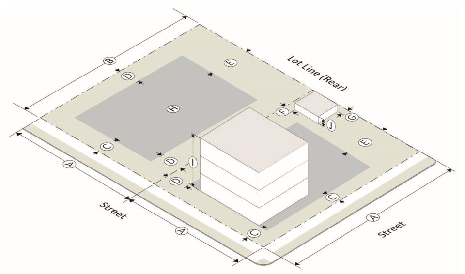
Sec. 4.11 Interpretation The following graphics depict the interpretation of lot development standards. The official definitions for these terms can be found in the Article 15, Definitions.
Ⓐ Lot Width Ⓕ Accessory Side Yard Setback Ⓑ Lot Depth (Interior or Through Lot Only Ⓖ Accessory Rear Yard Setback Ⓒ Principal Building Front Yard Setback Ⓗ Buildable Area Ⓓ Principal Building Side Yard Setback Ⓘ Principal Building Maximum Height Ⓔ Principal Building Rear Yard Setback Ⓙ Accessory Building Maximum Height
PUD Planned Unit Development.
Sec. 4.12 PUD Planned Unit Development.
The PUD district is intended to provide a means of accomplishing the following specific objectives:
| Lot Dimensions | ||
|---|---|---|
| Minimum Lot Area | 5-acres minimum INITIAL development site | |
| Minimum Lot Width | ||
| Minimum Lot Frontage | ||
| Maximum Density | ||
| Minimum Setbacks | ||
| Principal Building | ||
| Front | ||
| Side | ||
| Rear | ’ | |
| Accessory Building | ||
| From Principal Structure | ||
| Front | ||
| Side | ||
| Rear | ||
| Maximum Height | ||
| Principal | ||
| Accessory | ||
| Minimum Floor Area | ||
| Impervious Surface Coverage |
Supplemental Regulations Application of Regulations.
within the plan.
PUD Perimeter Compatibility Land uses developed at the perimeter of the site shall be developed in a manner that is compatible with adjacent off-site land uses or zoning, or a 100-foot wide buffer shall be provided between the uses in the PUD and the perimeter of the site. Compatibility shall be judged on the basis of similar land uses, average lot sizes, setbacks, and other development standards.
Traffic Study.
Traffic Study Required. A traffic study shall be required by the developer to determine the impact of the proposed development on the existing roadway system if the number of dwelling units exceeds 50 dwelling units or the non-residential components exceed 100,000 square feet of gross floor area (See Article 15 Traffic Study definition for required components).
Cross References for Article 3 The reference below are to sections of this code that contain requirements specific to this zoning district.
O-I Office-Institutional District
Sec. 4.13 O-I Office-Institutional District
| Lot Dimensions | |||
|---|---|---|---|
| Minimum Lot Area | 20,000 sf with sewer; 1 ac on septic | ||
| Minimum Lot Width | n/a | ||
| Minimum Lot Frontage | 50’ | ||
| Maximum Density | n/a | ||
| Minimum Setbacks | |||
| Principal Building | |||
| Front | 50’ | ||
| Side | 15’ if adjacent to non-residential district 30’ if adjacent to residential district | ||
| Rear | 15’ if adjacent to non-residential district 30’ if adjacent to residential district | ||
| Accessory Building | |||
| From Principal Structure | 0’ | ||
| Front | Not-Permitted | ||
| Side | 5’ if less than 144 sf 15’ if greater than 144 sf | ||
| Rear | |||
| Maximum Height | |||
| Principal | 50’ plus one foot of height for each foot of setback distance over 50’ to the closest property line of any residential district not to exceed 150” in height | ||
| Accessory | 15’ | ||
| Impervious Surface Coverage | As set by the watershed basin | ||
| Maximum Floor Area | With a special use permit – 1,000,000 sf | ||
| Without a special use permit – 50,000 sf | |||
| Minimum Building Separation | 20’ |
CG - General Commercial District
Sec. 4.14 CG - General Commercial District
| LOT DIMENSIONS | |
|---|---|
| Minimum Lot Area, Sewered | 10000 SF |
| Minimum Lot Area, Non-Sewered | 1 AC |
| Minimum Lot Width, Sewered | 60 FT |
| Minimum Lot Width, Non-Sewered | 60 FT |
| Minimum Lot Frontage | 50 FT |
| Maximum Density | N/A |
| MINIMUM SETBACKS | |
| Principal Building | |
| Front setback, Major Thoroughfare | 50 FT |
| Front setback, minor street, min | 30 FT |
| Side setback, min | 10 FT |
| Rear setback, min | 10 FT |
| Accessory Building (≤ 144 sf) | |
| From Principal Building | N/A |
| Front | N/A |
| Side | 5 FT |
| Rear | 5 FT |
| Accessory Building (≥ 144 sf) | |
| From Principal Building | N/A |
| Front, Major Thoroughfare | 50 FT |
| Front, Minor Thoroughfare | 30 FT |
| Side | 15 FT if adjacent to non-residential district 50 FT if adjacent to residential district |
| Rear | 15 FT if adjacent to non-residential district 50 FT if adjacent to residential district |
| MAXIMUM HEIGHT | |
| Principal building on a major arterial and on a lot of one (1) acre or more | 5 stories or 60 FT |
| Principal on any other thoroughfare | 3 stories or 40 FT |
| Accessory | 3 stories or 40 FT |
| Impervious Surface Coverage | As set by the watershed basin |
| Minimum Building Separation | 20’ |
| Maximum Floor Area | With a special use permit – 100,000 sf for a stand alone building With a special use permit – 1,000,000 for a planned center Without a special use permit – 50,000 sf |
CH - Heavy Commercial District
Sec. 4.15 CH - Heavy Commercial District
| Lot Dimensions | |||
|---|---|---|---|
| Minimum Lot Area | 10,000 sq. feet on sewer, 2 acres on septic | ||
| Minimum Lot Width | None | ||
| Minimum Lot Frontage | 50’ required on a major thoroughfare | ||
| Maximum Density | Depending on an approved development plan if residential is incorporated | ||
| Minimum Setbacks | |||
| Principal Building | |||
| Front | 50’ from the major thoroughfare applies to all structures including service areas and access drives. Front setbacks to the internal road network are recommended to be 0’ | ||
| Side | 15’ if adjacent to non-residential district at external lot line 50’ if adjacent to residential district at external lot line Internal side yard setbacks are recommended to be 0’ | ||
| Rear | 15’ if adjacent to non-residential district 50’ if adjacent to residential district | ||
| Accessory Building | |||
| From Principal Structure | 0’ | ||
| Front | Not Permitted | ||
| Side | 5’ if less than 144 sf 15’ if greater than 144 sf | ||
| Rear | |||
| Maximum Height | |||
| Principal building on a major arterial and on a lot of one (1) acre or more | 5 stories or 60 feet | ||
| Principal on any other thoroughfare | 3 stories or 40 FT | ||
| Accessory | 15’ | ||
| Impervious Surface Coverage | As set by the watershed basin | ||
| Minimum Building Separation | 20’ | ||
| Maximum Floor Area | With a special use permit – 100,000 sf for a stand alone | ||
| building | |||
| With a special use permit – 1,000,000 for a planned center | |||
| Without a special use permit – 50,000 sf |
PSP Public-Semi Public District
Sec. 4.16 PSP Public-Semi Public District
| Lot Dimensions | |||
|---|---|---|---|
| Minimum Lot Area | n/a | ||
| Minimum Lot Width | n/a | ||
| Minimum Lot Frontage | n/a | ||
| Maximum Density | n/a | ||
| Minimum Setbacks | |||
| Principal Building | |||
| Front | 50’ on major road, 30’ on minor | ||
| Side | 10’ 30’ if adjacent to residential district | ||
| Rear | 10’ 30’ if adjacent to residential district | ||
| Accessory Building | |||
| From Principal Structure | 5’ | ||
| Front | Not Permitted | ||
| Side | 5’ if less than 144 sf 15’ if greater than 144 sf | ||
| Rear | |||
| Maximum Height | |||
| Principal | 50’ plus one foot of height for each foot of setback distance over 50’ to the closest property line of any residential district not to exceed 150” in height | ||
| Accessory | 15’ | ||
| Impervious Surface Coverage | |||
| As set by the watershed basin |
Article 4, Division III - - Industrial Districts
General Provisions
Sec. 4.17 General Provisions The intent of the Industrial Districts is to protect established industrial areas as well as promote well designed and properly located future developments that create minimal impact on adjacent, incompatible uses.
Interpretation
Sec. 4.18 Interpretation The following graphics depict the interpretation of lot development standards. The official definitions for these terms can be found in the Article 15, Definitions.
Ⓐ Lot Width Ⓕ Accessory Side Yard Setback Ⓑ Lot Depth (Interior or Through Lot Only Ⓖ Accessory Rear Yard Setback Ⓒ Principal Building Front Yard Setback Ⓗ Buildable Area Ⓓ Principal Building Side Yard Setback Ⓘ Principal Building Maximum Height Ⓔ Principal Building Rear Yard Setback Ⓙ Accessory Building Maximum Height
LI Light Industrial District and LI-R Light Industrial-Restricted
Sec. 4.19 LI Light Industrial District and LI-R Light Industrial-Restricted
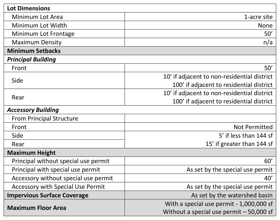
Accessory with Special Use Permit As set by the special use permit Impervious Surface Coverage As set by the watershed basin Maximum Floor Area With a special use permit - 1,000,000 sf Without a special use permit – 50,000 sf
.
HI Heavy Industrial District
Sec. 4.20 HI Heavy Industrial District
| Lot Dimensions | |||
|---|---|---|---|
| Minimum Lot Area | Initial site 5 acres Internal development lots a minimum of 1-acre | ||
| Minimum Lot Width | None | ||
| Minimum Lot Frontage | 50’ | ||
| Maximum Density | n/a | ||
| Minimum Setbacks | |||
| Principal Building | |||
| Front | 50’ | ||
| Side | 15’ if adjacent to non-residential district 100’ if adjacent to residential district | ||
| Rear | 15’ if adjacent to non-residential district 100’ if adjacent to residential district | ||
| Accessory Building | |||
| From Principal Structure | |||
| Front | Not Permitted | ||
| Side | 5’ if less than 144 sf 15’ if greater than 144 sf | ||
| Rear | |||
| Maximum Height | |||
| Principal without special use permit | 60’ | ||
| Principal with special use permit | As set by the special use permit | ||
| Accessory without special use permit | 40’ | ||
| Accessory with Special Use Permit | As set by the special use permit | ||
| Impervious Surface Coverage | As set by the watershed basin | ||
| Maximum Floor Area | With a special use permit - 1,000,000 sf | ||
| Without a special use permit – 50,000 sf |
Article 4, Division IV – Overlay Districts
General Provisions
Sec. 4.21 General Provisions As the name implies, overlay districts “over-lay” applicable base zoning district classifications to alter some or all of the base zoning district regulations that apply to particular sites. Overlay zoning districts work to modify or supplement the regulations imposed by base zoning district when necessary to address special situations or promote specific county planning goals. Overlay zoning is intended to be used when the base zoning district applied to an area remains generally appropriate, but when an additional, modified or eliminated requirement could help implement the county’s planning goals or address an area-specific planning, design or land use regulation issue. Certain districts are established as overlay districts, meaning that the "base" (or underlying) zoning district remains in place but the overlay adds additional provisions that override specific provisions of the base zoning district. The purpose of each of the overlay districts established in this Development Code is presented in this Section. All applicable regulations of the underlying base zoning district and of this Development Code apply to property in an overlay district unless otherwise expressly stated in the overlay district regulations. When overlay district regulations conflict with regulations that otherwise apply in the underlying base zoning district or with regulations otherwise imposed by this Development Code, the more restrictive regulations govern.
Reserved
Sec. 4.22 Reserved Sec 4.21(a) O-HC Highway Corridor Overlay
Trees must be spaced no more than 40 feet on center.
| Minimum Ground Story Facade Transparency (%) | |
|---|---|
| Front Street Façade (by building type/occupancy) | |
| Multi-unit Residential, Office or industrial | 20 |
| Retail, Entertainment, or Commercial Service | 35 |
| Side Street Facades (by building type/occupancy) | |
| Multi-unit Residential, Office or industrial | 20 |
| Retail, Entertainment, or Commercial Service | 25 |
| Minimum Upper-Story Facade Transparency | |
| Front Street Façade | 15 |
| Side street Façade | 15 |
| Maximum Upper-Story Blank Wall Width (feet) | 20 |
| Street-facing Building Entrances | |
| Front Street | Required |
| Side Street | Not Required |
| Maximum Distance Between Required Entrances (feet) | 175 |
| Building Material Coverage Street Face (%) See 4.23(7)e | |
| Traditional Masonry (Minimum) | 80 |
| Building Material Coverage Side/Rear Face (%) | |
| Traditional Masonry (Minimum) | 30 |
| Synthetic Stucco (Ground-Story Maximum) | 60 |
| Synthetic Stucco (Upper-Story Maximum) | 75 |
| Building Mass Variation (based on building width) | |
| 50−200 Feet Building Width | Not Required |
| Over 200 Feet Building Width | Required |
| Façade Articulation (based on building width) | |
| 50−200 Feet Building Width | Not Required |
| Over 200 Feet Building Width | Required |
| Roof Forms | |
| Allowed Types | Pitched, Flat, Parapet |
arterial roads
Material coverage is calculated as the total street-facing facade area clad in the required or regulated material divided by the total street-facing facade area.
Examples of alternative materials that can be approved include:
Such roofs must have a minimum 4:12 pitch. Eaves with a minimum depth of 12 inches are required on all pitched roofs. Roofing materials are limited to the following:
All lighting for commercial development shall be designed to integrate with the overall development character.
Sec 4.21 (b) O-QGD Quality Growth Development Overlay.
The O-QGD Quality Growth Development Overlay District is established to promote high-quality development in areas of the county that are largely undeveloped but in the path of rapid, substantial residential, commercial, or industrial development that is anticipated will radically change the character of the lands within the District boundaries. This District is designed to encourage high-quality development by establishing restrictions and standards to protect the natural environment, promote optimum development, and so that investment values will be maximized and will not be endangered by unsightly, undesirable, or incompatible development on adjacent properties in the foreseeable future.
The primary goals of the O-QGD overlay district are to provide a positive climate for high-quality investment and development, to provide a sense of place and orientation, to provide an attractive and functional environment, to ensure a harmony of uses and development, and to provide a comfortable, secure, and harmonious developed environment.
Any multi-family residential, commercial, office, office distribution, or industrial use within the O-QGD shall comply with the landscaping requirements of this section in addition to the applicable requirements and standards of Article 2, Article 8 and Article 9.
The location and detail of all required landscaping shall be depicted on the site landscaping plan (see the Procedures and Permits Article of this Development Code).
Minimum required landscaped area.
Each site shall have a minimum landscaped area of 25 percent. The calculated landscaped area may include tree islands within required parking areas.
Frontage landscape strip.
A minimum 25-foot wide landscape strip adjacent to the street right-of way shall be provided in such a way so as to achieve maximum screening effect, which may include installation at the road elevation or higher, based on the discretion of the Director.
Every 100 feet of linear landscape strip must include a minimum of 3 canopy trees, 3 understory trees, 2 evergreen trees, and 18 shrubs. Planting standards may be reduced up to 50% with the provision of a 5 feet tall earthen berm running the entire length of the landscape strip.
Side and rear yard landscaping.
Unless otherwise required in Article 8 of the Unified Development Code, all required side and rear yards shall be landscaped in accordance with the requirements of this article.
Other landscape areas.
All land surfaces other than those covered by permitted buildings, structures, paving, or other required site elements shall be landscaped with well-maintained grass, flowers, shrubs, or other suitable plant materials.
Natural buffers.
Natural buffers shall be supplemented with native plantings when existing vegetation on the site does not provide a minimum of 80% opacity between the proposed use and the adjacent residential district. These plantings shall include a mixture of canopy trees (50% must be evergreen), understory trees, evergreen coniferous trees and shrubs.
Canopy trees shall be no less than 3 inches in caliper and no less than 15 feet in height at the time of planting with a mature height of no less than 25 feet.
Any multi-family residential, commercial, office, office distribution, or industrial use within the O-QGD shall comply with the screening requirements of this section in addition to all other applicable requirements and standards of this Development Code.
All loading areas, outdoor service equipment, and outdoor storage areas, including those for trucks, busses, automobiles stored more than 48 hours, or the storage of any other vehicles or equipment shall be screened from street or adjacent property view by an attractive solid masonry wall finished on the exterior side by the same material used for the façade of the building. Such wall shall be not less than 5 feet in height and no more than 8 feet in height.
Specific height, as dictated by all applicable ordinance provisions, shall be determined during the site plan review process. If loading areas, service equipment or outdoor storage areas are not adjacent to residential zoning or visible from a public right-of-way, the Director may allow for reduction or elimination of these screening requirements.
No screening is required to separate adjacent uses that are the same or similar.
A natural or structural buffer may be substituted for up to 25 percent of the required screening.
If a building structure faces a public street or is directly adjacent to a residentially zoned property, and has less than 25% glazing or openings (doors, windows, and service entries) on the façade facing the public street or residentially zoned property, a landscape screen shall be provided between the building structure and the residentially zoned lot in addition to any buffers required by Article 8 of this Development Code. Such screen must be a minimum of 15 feet in width and run the entire length of the subject building façade except where there are breaks for building access. Every 100 feet of linear building landscaping screen must include: 6 canopy trees (3 of which must be evergreen), 2 understory trees, 3 evergreen coniferous trees, and 18 shrubs. Canopy trees shall be no less than 3 inches in caliper and no less than 15 feet in height at the time of planting with a mature height of no less than 25 feet. Understory trees shall be deciduous or evergreen trees that typically grow to a mature height of less than 40 feet. The Director may allow for reduction or elimination of this requirement for building landscaping and screening if determined the requirement to be unfeasible based on specific conditions of the property.
The sign regulations of Article 7 in regard to the number and size of signs apply in the QGO district as determined by the appropriate base zoning district.
All signs shall be composed of wood, stone or other similar materials.
Any fences or walls not required for screening under this section shall be composed of stone, decorative metal or decorative block. If located parallel to a street and within 30 feet of that street, these fences or walls shall comply with Article 8 of this Development Code.
Chain link, unfinished concrete or cinderblock, plastic or fiberglass, barbed or razor wire, and wood fences are prohibited. Paint shall not be used as a finish material. Exceptionally, the above prohibited materials may be utilized on a security fence if located inside an approved screening fence, wall, or other screening element as specified above.
Except for one-story warehouse, storage, or distribution buildings which are limited to a maximum building coverage ratio of 45 percent, the ratio of building coverage to the total lot area shall in no case exceed a ratio of 55 percent, unless otherwise approved by the Director.
The ratio of total floor area of all buildings on a lot to the total site area (Floor Area Ratio) shall not exceed a ratio of 150 percent (or 1.5 times the total site area), unless otherwise approved by the Director.
Any building facing a public street or directly adjacent to a residentially zoned lot shall not have wall planes exceeding 30 feet in length without a change in plane by means such as a vertical recess, projection, change in material or color or pilaster. Changes in roof planes shall occur at locations with changes in wall planes.
Aluminum, steel, vinyl, mirrored or reflective glass, raw cinderblock, unfinished concrete, fiberglass or plastic are prohibited, except as architectural detailing and decorative trim of not more than 15% of any one façade, unless greater percentage is approved by the Director.
Exterior finish materials visible from any public street shall be any of the following:
glass windows and glass doors on each floor visible from a public street unless directly screened by an adjacent building landscaping screen, unless otherwise approved by the Director.
Exterior finish materials for side and rear facades shall be any of the following:
Natural stone including granite, marble, sandstone, field stone or any other natural stone;
Manufactured stone including imitation field stone, marble terrazzo, and any other manufactured architectural finish stone;
Clay tile with baked-on enamel finish;
Architecturally treated decorative concrete block;
Architecturally treated slabs or block either fluted or with exposed aggregate;
Stucco on lathe or a synthetic stucco material (including EIFS) or an acceptable substitute.
Fiber cement/cementitious siding (board or plank).
Sec 4.21(c) Mixed-use master planned developments.
Sec 4.21(d) Master planned developments.
Sec 4.21(e) O-ED Estate Density Overlay District.
The O-ED overlay district is established to protect and promote a suitable environment for rural or "large lot suburban" family life, agriculture including the raising of livestock and poultry, and the development of natural resources and other uses requiring extensive areas of land. This overlay district is required to protect the future development of land in accordance with the comprehensive plan of the county as amended. The O-ED overlay district shall place the following restrictions in addition to those in the overlaid districts. The minimum lot size and density requirements of this overlay district shall be met unless greater area is required for a use by the zoning district in which the property is located.
All permitted uses that are allowed by this Development Code on a property by the applicable base zoning district are permitted provided they do not conflict with any requirement of this Section.
The O-ED Overlay District is described as all those portions of Land Lots 1 through 6, 31 through 37, 39, 40 and 63 of the 1st District, 5th Section; Land Lots 1 through 3 and 32 of the 2nd District, 5th Section; and Land Lots 1 through 5, 7 through 13, and 23 of the 3rd District, 5th Section of Douglas County that are within the Bear Creek Watershed Protection District as defined on the Official Zoning Map of Douglas County. This area shall exclude parcel numbers 0006-015-0001, 0006-015-0006, 0006-015-0007, 0006-015-0008, 0006-015-0010, 0007-015-0002, 0007-015-0002, 0040-015-0016, 0041-015-0001 located on the official tax map of Douglas County.
The O-ED Overlay District is further described as all those portions of Land Lots 148 through 152; 165, 166, 170 through 172, 181 through 184, 187 through 189, 195 through 198, 200 through 207, 210 through 222, 226 through 239, 242 through 248 of the 2nd District, 5th Section; and Land Lots 562 through 565, 623 through 629, 644 through 657, 680 through 696, 711 through 730 of the 1st District 3rd Section as defined on the Official Zoning Map of Douglas County.
The following requirements shall be met before any permits will be issued. When these requirements conflict with those in the R-A and R-LD zoning districts, as applicable to a particular property, the more restrictive shall apply.
A single-family dwelling shall comply with the following minimum density and lot size requirements:
Any use other than a single-family dwelling shall occupy a property containing no less than 3 acres (130,680 square feet) of gross lot area.
Land within a subdivision that is not included within individual building lots shall be set aside as common open space. Such open space and primary and secondary conservation areas shall comply with the following provisions:
All primary conservation areas, and all secondary conservation areas designated by the developer for protection, shall be included within a conservation or natural resource easement (as applicable) in accordance with the requirements for such easements contained in the Environmental Protection Article of this Development Code
All common open space shall be owned by a homeowners' association in accordance with the requirements for such property owners' associations under the Subdivisions and Planned Developments Article of this Development Code.
Sec 4.21(f) O-LF Landfill Overlay.
The O-LF Landfill Overlay District is established in order to protect properties near existing or previously closed solid waste disposal facility from well-water contamination and from the buildup of methane gas within enclosed buildings. It is the intent of this overlay district to maintain compliance with requirements imposed by the Georgia Department of Natural Resources, Environmental Protection Division (Chapter 391-3-4, Solid Waste Management).
The O-LF district is hereby established to include all areas located within ½-mile (2,640 feet) of the property line of a property on which is located a solid waste disposal facility permitted under the rules of the Georgia Environmental Protection Division, whether currently active or previously closed.
Relief from the restrictions imposed by the O-LF Landfill Overlay District may be requested under the Appeals Article of this Development Code.
Sec 4.21(g) Airport Hazard Overlay District The O-AH Airport Hazard Overlay District provides restrictions that supplement or override provisions of the underlying zoning districts beneath the airport zone, and includes all areas shown on the map labeled as such and adopted as part of the Official Zoning Map as required by Federal Aviation Regulations (FAR) Part 77.
Airfield: In this section the terms "airfield" and "airport" are interchangeable and mean airfields in Douglas County.
Approach-departure clearance surface: This surface is symmetrical about the runway centerline extended. It begins as an inclined plane (glide angle) two hundred (200) feet beyond the end of the runway at the same elevation as the runway end, and extends for 50,000 feet. The slope of this surface is fifty to one (50:1) (glide angle) for military airports, along the runway centerline extended for 25,000 feet, at which point it reaches an elevation of 500 feet above the elevation of the runway end. It then continues horizontally at this elevation for an additional 25,000 feet. The width of this surface at the starting point (200 feet from the runway end) is 2,000 feet. It flares uniformly and the width at 2.5 miles is 2,696 feet. Glide angles for other types of airports shall be determined by consultation with the county engineer.
Flight hazard: Any structure or natural growth or use of land that obstructs or restricts the airspace required for the safe flight of aircraft in landing, takeoff or maneuvering areas as or in the vicinity of the airfield.
Landing area: That part of the airfield that is used or intended to be used for landing and takeoff of aircraft.
Structure: An object, including a mobile object, constructed or installed by man, including, but without limitation, buildings, towers, cranes, smokestacks, earth formations and overhead transmission lines.
To carry out the purposes of this section, all of the land within the boundaries of the future airfields in Douglas County and within one mile of the runway centerline extended of each instrument runway affected, for a distance of 2.5 miles from each end of such runway, is hereby declared to be a compatible use zone (CUZ) divided into three sub zones. The sub zones are:
Except as otherwise provided in this section, no structure or natural growth shall be erected, altered, allowed to grow or maintained in the CUZ to a height in excess of the height specified below for each sub zone.
No use may be made of land or water within the Airport Hazard Overlay District in such a manner as to create electrical interference with navigational signals or radio communication between the airport and aircraft, make it difficult for pilots to distinguish between airport lights and others, result in glare in the eyes of the pilots using the airport, impair visibility in the vicinity of the airport, create bird strike hazards, or otherwise in any way endanger or interfere with the landing, takeoff, or maneuvering of aircraft intending to use the airport.
The limitations prescribed in this Section shall not be construed to require the removal, lowering, or other change or alteration of any structure or natural growth not conforming to the regulations of this Division as of the effective date hereof, or otherwise interfere with the continuance of any nonconforming use. Nothing contained in this Division shall require any change in the construction, alteration or intended use of any structure, the construction or alteration of which has begun prior to the effective date of this Development Code and is diligently prosecuted and completed within two years thereof.
Any person desiring to erect any structure or increase the height of any structure, or permit natural growth, or use such person's property, not in accordance with the regulations prescribed in this Division, may apply for a hardship variance under the provisions of the Procedures and Permits Article of this Code. Such variance may be allowed where a literal application or enforcement of the regulations would result in practical difficulty or unnecessary hardship and the relief granted would not be contrary to the public interest, but do substantial justice and be in accordance with the spirit of this section.
Any variance granted under Section 4.30 (f), if such action is considered advisable to effectuate the purposes of this Division and reasonable in the circumstances, may be so conditioned as to require the owner of the structure or natural growth in question to permit the airport operator at the owner's expense to install, operate and maintain thereon such markers and lights as may be necessary to indicate to airport pilots the presence of a flight hazard.
Included in any application for approval of an Airport Hazard Overlay District or for a variance under Sec.
4.21(g) there must be written approval by the Federal Aviation Administration that the property in question will be suitable for development as an airport or that the variance will not be inconsistent with FAA rules and regulations.
Section 4.21(h) Westfork and Thornton South Overlay
Depth is measured from the right-of-way.
specifically, Section 1(C) for Residential and Section 2(B)(6-7) for Non-Residential shall govern. Alternative provisions may be provided at the discretion of the Director of Development Services if it is determined that the proposed elevations would be of a similar architectural style and finish to structures currently existing in the immediate vicinity along the street frontage of the proposed structure.
enclosure finished in a similar finish of the principal building.
Section 4.21(j) Central West Workplace Campus Overlay
Frequency (Cycles per Second)
Displacement (Inches)
10 and below 0.0008 10—20 0.0005 20—30 0.0003 30—40 0.0002 40—50 0.0001 50 and above 0.0001
Any change to the regulating plan not otherwise approved by the Director of Development Services shall be presented to the Douglas County Board of Commissioners as a zoning amendment to approve or deny in accordance with Article 12 of this Code.
Section 4.21(k) Cedar Mountain Overlay
It is comprised of geologic features that contribute to a habitat which sustains a rare botanical environment.
The predominant geologic unit underlying Cedar Mountain is Ropes Creek Metabasalt. Calcium-rich soils, such as those found over Ropes Creek Metabasalt support a disproportionately large number of rare plant species found within Georgia. Distinct rock outcroppings support unique and diverse assemblages of native plants, some of which are rare botanical species. Cedar Mountain also holds potential for the identification of rare and endangered animal species dependent on the unique ecosystem.
The Piedmont Mafic Dry-Oak Hickory Forest is threatened by forest conversion and habitat destruction. Evidence of pre-historic occupation and early settlement may contribute to understanding the early history of Douglas County. The topography changes of the wooded and granite outcrops, along with scenic long vistas, contribute to the unique sense of place in Douglas County.
It is the intent of this ordinance to identify appropriate measures to mitigate any land use or development that would potentially be a detriment to the natural, scenic or cultural environmental of this unique and valuable resource.
Article 4, Division V – Supplemental Development Standards
Minimum lot frontage.
Sec. 4.30 - Minimum lot frontage.
No principal building shall be erected on any lot that does not have immediate frontage on at least one street or road for a distance of not less than 50 feet. However, the required frontage may be 35 ft. on a cul-de-sac or at such length specifically permitted within individual district regulations. Exceptions to this rule are contained in the following paragraphs.
Sec. 4.30 (a) Townhouse lots.
A townhouse subdivision lot shall have at least 20 feet of frontage on a public or private street.
Sec. 4.30 (b) Frontage for large lots.
Tracts greater than 5 acres in size that are exempt from the subdivision regulations are eligible for building permits, provided they have no less than 25 ft. of frontage on a public street or access via a recorded permanent easement at least twenty-five feet in width.
Sec. 4.30 (c) Exception.
The Board of Commissioners may grant an exception to allow one single-family dwelling and related accessory structures on tracts of at least 5 acres that do not comply with the standards above, provided the tract was created prior to 7 March 2000. The owner shall demonstrate to the board that the tract is suitable for dwelling construction and has reasonable vehicular access via frontage or a recorded easement of no less than 25 feet in width.
Sec. 4.30 (d) Street frontage required.
Every property must front on a street from which direct access can be gained that has been opened and accepted as a public street, or is a private street meeting public street design and construction standards or as otherwise specifically approved by the Board of Commissioners.
Residential density and lot area.
Sec. 4.31 - Residential density and lot area.
Sec. 4.31 (a) Minimum requirements.
Every property upon which a residential use will be located shall meet or exceed the requirements shown on the Development Standard Tables of this Article 4 for the zoning district in which the lot is situated. The minimum lot size must be met by each lot in a conventional subdivision.
Sec. 4.31 (b) Areas excluded from minimum lot computations.
Sec. 4.31 (c) Maximum density.
Sec. 4.31 (d) Minimum buildable area.
Nonresidential lot area.
Sec. 4.32 - Nonresidential lot area.
Every property upon which a commercial, industrial or institutional use will be located shall meet or exceed the requirements shown on the lot development standard Tables for each district depicted in this Article 4 for the zoning district in which the lot is situated.
Minimum lot size on septic tank.
Sec. 4.33 - Minimum lot size on septic tank.
Sec. 4.33 (a) Minimum lot size established.
The minimum lot sizes shown on the development standard Table for each district depicted in this Article 4 for lots with septic tanks establish the minimum lot sizes on a nonresidential property and in a residential subdivision on which the County Health Department will approve an on-site sewage management system. The "non-sewered" figures shown assume that public water is supplied to the lot;
minimum lot requirements are larger for lots on individual wells.
Sec. 4.33 (b) Lot size increases.
The County Health Department will require larger lot sizes in individual cases based on a variety of factors, such as:
Minimum lot width.
Sec. 4.34 - Minimum lot width.
Sec. 4.34 (a) Minimum lot width established.
Sec. 4.34 (b) Lot width increases.
The lot width required on an individual lot may be wider than the minimum for a variety of reasons, such as:
Minimum setbacks; principal buildings.
Sec. 4.35 - Minimum setbacks; principal buildings.
All principal buildings on a lot shall be set back from the minimum required right-of-way lines and from the side and rear lot lines bounding the lot no less than the distances shown on Lot Development Standards Tables of this Article. See definition of "principal building setback line" for application of the setback requirements. Prior to any inspections, all property lines immediately adjacent to any proposed structure, shall be staked by a registered land surveyor in order to assure all required setbacks have been met.
Setback: The shortest straight-line distance between a street right-of-way or lot line and the nearest point of a structure or building or projection therefrom (excluding roof overhangs of 18 inches or less), measured at 90 degrees to the street or lot line.
Sec. 4.35 (a) Thoroughfares, defined.
Section 4.35 (b) Measurement of Side and Rear Setbacks
Minimum setbacks; accessory buildings and structures.
Sec. 4.36 - Minimum setbacks; accessory buildings and structures.
See Article 3, Section 313(a)(3) Restrictions on Specific Uses.
Minimum floor area within a dwelling unit.
Sec. 4.37 - Minimum floor area within a dwelling unit.
Minimum building floor area (as defined in this Code) in the agricultural and residential zoning districts shall be as follows:
Sec. 4.37 (a) Minimum floor area; AG, R-A, R-LD and R-MD districts.
The following shall control the minimum building floor area requirements for dwelling units in the AG, R-A, R-LD and R-MD zoning districts:
A single-family dwelling unit constructed on a lot created as part of a subdivision shall meet the following minimum building floor area requirements: 1,800 square feet.
A single-family dwelling unit constructed on a lot not created as part of a subdivision shall meet the following minimum building floor area requirement: 1,800 square feet.
Sec. 4.37 (b) Maximum occupancy provisions.
Occupancy within a dwelling unit is not allowed to exceed the following number of persons, based on the amount of building floor area within the unit:
Building and structure heights.
Sec. 4.38 – Building and structure heights.
Sec. 4.38 (a) Building and structure heights; how measured.
The vertical distance measured to the highest point of a building from the average finished grade across those sides of a building that face a street.
The vertical distance to the highest point of a structure (other than a building), as measured from the average grade at the base of the structure or from the average grade directly below a projecting structure.
Sec. 4.38 (b) Maximum building and structure heights.
The maximum height of all buildings and structures in each zoning district, except as otherwise provided in this Section, shall be as shown on Table 4.6.
The following structures are exempt from the height limitations imposed by this Section, provided that no structure may exceed 200 feet in height from the average finished grade at its base:
Fences and freestanding walls (other than retaining walls) cannot be located within any public right-of-way, and may not exceed the following height restrictions:
Height limitations for radio, television and telecommunication antennae and towers are contained in the Radio, Television and Telecommunications Section of Article 3.
Criteria for the use of solar energy equipment.
Sec. 4.39 - Criteria for the use of solar energy equipment.
Sec. 4.39 (a) General.
Sec. 4.39 (b) Ground-mounted solar energy equipment.
Sec. 4.39 (c) Roof or wall-mounted solar energy equipment.
Sec. 4.39 (d) Permits required.
Installation of solar equipment shall be permitted through the building department.
Sec. 4.39 (e) Ground-mounted solar power energy system.
A ground-mounted solar power energy system or "solar farm" operating as a use-by-right must meet the following standards:
consecutive months, the property owner or equipment owner shall remove the collector, mount and associated equipment by no later than 90 days after the end of the twelve-month period.
Once the equipment is removed, the ground shall be stabilized and replanted in accordance to the requirements of Article 8 of the Unified Development Code and subject to the approval of the Douglas County Arborist.