Article 10 — Project Design and Construction Standards
Purpose of Article 10.
Sec. 1001 - Purpose of Article 10.
This Article sets out the minimum requirements and standards for construction of subdivisions and other land development projects, including general principals of design and layout and requirements for such public facilities as streets and utilities.
Standards incorporated by reference.
Sec. 1002 - Standards incorporated by reference.
1002 (a) Standard design specifications.
The Construction Standards and Specifications of Douglas County, also referred to in this Code as "Standard Design Specifications," as maintained by the Department of Transportation and as may be amended from time to time by said department, are incorporated into this Code as though set forth within the body of this Code. In the case of a conflict between the Standard Design Specifications and the text of this Code, the text of this Code shall control.
1002 (b) Traffic signs and street striping.
The installation of all traffic control signs and street striping shall be governed by the standards contained in the Manual on Uniform Traffic Control Devices , latest edition, published by the Federal Highway Administration of the U.S. Department of Transportation.
1002 (c) Georgia DOT standard specifications.
Unless otherwise specially set forth in this Code or the Standard Design Specifications, all of the materials, methods of construction, and workmanship for the work covered in reference to street construction and storm drainage construction shall conform to the latest standard specifications of the Georgia Department of Transportation.
1002 (d) AASHTO design standards.
1002 (e) Street lighting.
The American National Standard Practice for Roadway Lighting of the Illumination Engineering Society, as approved by the American National Standards Institute (1973), or as more recently amended, shall be consulted regarding illumination of public rights-of-way.
General design standards.
Sec. 1003 - General design standards.
1003 (a) Suitability of the land.
1003 (b) Conformance to the adopted plans of Douglas County.
In addition to the requirements established herein, all subdivisions and individual development projects shall comply with the following laws, rules and regulations:
If the developer reserves land for any public facility other than transportation facilities and it is not acquired by gift, purchase, condemnation or otherwise nor optioned by the appropriate public agency within 5 years from the date of recording of the subdivision or by the time Certificates of Occupancy have been issued for 75% of the dwelling units in the development, whichever occurs first, the subdivider may claim the original reservation, or portion thereof, and cause it to be developed in a manner suitable to the subdivider subject to the provisions of this Development Code.
The Director of Development Services may waive the platting and reservation requirements of this Section 1003 (b)(3) whenever the public body responsible for land acquisition executes a written release stating that such a planned feature is not being acquired.
1003 (c) Name of subdivision or development project.
The name of each subdivision or development project must have the approval of the Development Services Department. The name shall not duplicate nor closely approximate the name of an existing subdivision or development project in Douglas County or any of its cities.
1003 (d) Street names.
street, avenue, boulevard, road, pike, drive, way, place, court or other derivatives.
1003 (e) Street addresses.
Street addresses shall be obtained from the Development Services Department and shall be shown on each final plat.
1003 (f) Blocks.
Blocks for other than residential use shall be of such length and width as may be suitable for the prospective use, including adequate provision for off-street parking and service.
1003 (g) Lots.
All lots shall meet or exceed the area and dimensional requirements of this Development Code for the zoning district and type of development in which the lots are located.
Nothing contained in this Article shall be construed as preventing the County Health Department, after study of the conditions existing in a proposed subdivision, from requiring that all or any portion of the area of such subdivision shall not be built upon or that the minimum lot sizes set forth in this Development Code are inadequate and must be increased to ensure the protection of the public health.
Each lot shall contain a site large enough for a normal building that will meet all building setback requirements as set forth in this Code and not be subject to flood or periodic inundation
Insofar as practical, side lot lines shall be at right angles to straight street lines or radial to curved street lines (including cul-de-sacs).
Corner lots shall be sufficiently large to permit the location of buildings so as to conform to the front building lines on both streets.
On through lots (i.e., "double-frontage" lots) the minimum front yard setback for principal buildings shall be provided along each street.
Flag lots must meet the minimum lot width for the applicable zoning district at the minimum front setback line required for principal buildings.
The subdividing of land adjacent to or surrounding an existing or proposed lake, shall be such that lots abutting the lake shall be drawn to the centerline of the lake. Such requirements may be waived upon submittal to the Board of Commissioners of an acceptable method for the maintenance of the lake and any recreational operations to be provided thereon. The minimum required area of each lot shall exclude those areas as specified in Section 404(b) of the Lots and Building Standards Article of this Development Code.
1003 (h) Areas reserved for future development.
If any portion of a tract is reserved for future subdivision development, the minimum lot width and frontage of the reserved area may be reduced to the width required for a future street to serve such area.
1003 (i) Plats straddling political boundaries.
Whenever access to a subdivision is required across land in another governmental jurisdiction, the Department of Transportation Director may request assurance from the County Attorney, and/or the other jurisdiction that access is legally established, and that the access road is adequately improved. In general, lot lines shall be laid out so as to not cross jurisdictional boundary lines.
1003 (j) Design standards for planned developments.
Required improvements.
Sec. 1004 - Required improvements.
1004 (a) Minor subdivisions.
A "minor subdivision" is one in which limited public improvements (such as new streets, stormwater drainage facilities or public utilities) are required. However, the following improvements are required in order to adequately serve the lots and protect the safe operation of the existing road:
502(a) are applicable.
Driveway Permits are obtained from Douglas County Department of Transportation. Driveways shall be positioned to provide maximum visibility along the County roadway.
1004 (b) Major subdivisions, multi-family and nonresidential developments.
The following improvements shall be provided by the developer or at the developer's expense in every major subdivision or individual multi-family or nonresidential development in accordance with the requirements and standards contained in this Article. Prior to construction of any major subdivision or multi-family or nonresidential development, a pre-construction meeting shall be scheduled with the Department of Transportation.
1004 (c) Guarantee in lieu of completed improvements.
No final subdivision plat shall be approved by the County or accepted for recordation by the Clerk of the Superior Court until one of the following conditions has been met:
Survey monuments.
Sec. 1005 - Survey monuments.
Survey monuments shall be installed in accordance with Chapter 180-7, Technical Standards for Property Surveys, Rule 180-7-.05 of the Rules and Regulations of the State of Georgia. In the event of conflict, the State rules shall govern.
1005 (a) Exterior development boundaries.
1005 (b) Lot and street corners.
1005 (c) Floodplain elevations.
On developments containing floodplains, flood elevation references shall be set.
Utility easements.
Sec. 1006 - Utility easements.
1006 (a) Notice of intention to utilize right-of-way.
Any public utility seeking to condemn or utilize an easement over or through or within the paved portion of the public right-of-way which is under the supervision and control of the county, in order to run wires, pipes, cables, maintain dams, flow backwater, or for any other uses necessary to its purpose, shall first notify the Department of Transportation Director or its designated agent of the utility's intention to so condemn or utilize, and all cases other than condemnation said utility shall obtain a permit from the Department of Transportation Director. Utilization shall mean any manner of use of the above-described right-of-way, including but not limited to, cutting of the pavement or boring under the pavement. Such notification shall include the location and description of the right-of-way to be condemned or utilized and the purpose of the condemnation or utilization. In the event of emergency repair service involving utilization of the paved portion of the right-of-way during hours other than normal office hours, the utility shall notify the Department of Transportation on the next business day.
1006 (b) Promulgation of standard specifications.
The Department of Transportation Director is hereby authorized to prepare standard specifications regulating the installation of pipes, wires, cables, poles, lines, etc., over, through or within a public right-of-way. These specifications shall be in conformance with the requirements of this Section and shall be designed to protect and safeguard the welfare of the county and its citizens. (A copy of the specifications shall be available for public view during normal business hours at the Department of Transportation office.)
1006 (c) Approval of installation.
As to new installation, no public utility shall install any lines, wires, pipes or poles, or otherwise utilize a public right-of-way until after obtaining prior written approval from the Department of Transportation Director respecting the proposed location of said lines, wires, pipes, etc., in accordance with these regulations. The Department of Transportation Director shall determine if the installed location and placement of any utility along a public right-of-way meets the requirements of this Section and the standard specifications of the County (see Sec. 1006 (b)). The Department of Transportation Director shall then issue a written approval or disapproval to the public utility regarding the installation. Any installation made by any utility in a location other than that specified in this Section shall be removed and reinstalled in the proper location entirely at the expense of the utility. Failure to reinstall at the proper location will result in the withholding of any further installation permits. Failure to conform to this Section or the permit will result in the withholding of any further installation permits.
1006 (d) Location of utility lines and structures.
Water, electrical, telephone and cable television lines shall be located on the south or west side of any road, highway or street; and gas, electrical, telephone and cable television lines shall be located on the north or east side of any road, highway or street. The determination of which side is north and which side is south and which side is east and which side is west shall be made at the point where said street, road or highway begins. If there is any question regarding which side of the highway, road or street any particular utility should use, then said utility shall contact the Department of Transportation Director. The Department of Transportation Director shall then instruct the public utility regarding which side of a specific road, street or highway the particular utility should use.
1006 (e) Variances.
The Department of Transportation Director is authorized to approve a variance from the requirements of Sec. 1006 (d), if, in its opinion, such variance is absolutely necessary under the conditions then and there existing; and, such variance will not create a public hazard or otherwise be detrimental to the best interest of the county and its citizens. The Department of Transportation Director shall keep a record of all variances granted under this subsection. This record shall include the name of the utility to which said variance is granted, the description and location of the variance, and the reasons for granting said variance.
1006 (f) Use of minimum area; restoration of disturbed areas.
Any utility shall condemn or utilize only that portion of a public right-of-way necessary for the purpose intended. It shall leave undisturbed the area surrounding the condemned or utilized right-of-way and shall replace or repair, in kind, any structures, shrubbery, driveways, embankments, ground cover, etc., which are altered or disturbed while installing pipes, wires, ditches, or otherwise using the public right-of-way, and shall regrade the undisturbed area to its original contours. The replacement of shrubbery, ground cover etc. shall not impede sight distance and plantings are limited to a mature height of two (2) feet.
1006 (g) Excavations; backfilling.
No street cuts for crossings will be made unless specifically approved by the Department of Transportation Director after at least three attempts to bore at different locations. Patches shall be made in accordance with county standards.
1006 (h) Liability for costs and expenses.
Any costs or expenses incurred by the county in repairing or replacing any such structures, etc., as described in Sec. 1006 (b), which are not left in their original condition by the public utilities shall be chargeable to the public utility, including reasonable attorney's fees incurred in the collection of said costs or expenses. Street cuts altering existing pavement markings shall replace pavement markings with like material as described in Sec. 1009 (c).
1006 (i) Inspections.
The utility cutting the asphalt of the roadway for the installation/repair of a utility is required to notify the Department of Transportation Director, in advance, of the date and time of the roadway backfilling and repaving so that the Department of Transportation Director can schedule an inspection of this work.
1006 (j) Penalties.
Any utility that does not notify the Department of Transportation Director in advance of the date and time of the roadway backfilling and repaving, shall be fined in accordance with Article 14 of this Development Code. In addition, the utility may be required by the Department of Transportation Director to core the patching, at the utility's cost, to determine its compliance with the Douglas County Standard Specifications. All cost or expenses incurred by the county in repairing or replacing any structure, shrubbery, driveway, embankment, ground cover or any other item which has been altered or disturbed and not left or returned to the original condition by the utility, shall be chargeable to the utility which disturbed the area or cut the county roadway. The county shall be entitled to collect reasonable attorney's fees incurred in the collection of such costs or expenses and all costs of collection.
1006 (k) Overlapping easements.
Easements for water, sanitary sewers and drainage purposes may be combined, but must comply with all requirements of the WSA as to width, pipe separation, etc.
Other easements.
Sec. 1007 - Other easements.
Easements other than utility easements shall be required in connection with subdivisions or developments for the following purposes, among others:
1007 (a) Pedestrian easements.
Pedestrian easements not less than 10 feet wide, may be required where deemed essential to provide circulation, or access to schools, playgrounds, shopping centers, transportation, and other community facilities.
1007 (b) Drainage easements.
1007 (c) Conservation and natural resource easements.
Conservation and natural resource easements, as may be required by this Development Code, shall be clearly defined on the plat and deed of the individual property owner, and must conform to the requirements set out for such easements in the Environmental Protection Article of this Code.
Streets.
Sec. 1008 - Streets.
1008 (a) Access.
1008 (b) Street classifications.
Streets are classified according to the function that they serve, the type, speed, and volume of traffic they will carry and the required standards of design. The classifications of streets and roads are as shown on the latest approved or amended Comprehensive Plan or Transportation Plan for the County.
1008 (c) Relation to present and future street system.
Subdivisions and development sites that adjoin only one side of an existing street shall dedicate one-half of the additional right-of-way needed to meet the minimum width requirement for the street classification. If any part of the subdivision includes both sides of an existing street, all of the required additional right-of-way shall be dedicated to the County at no cost.
1008 (d) Design standards for streets.
All State or U.S. numbered highways shall meet all design requirements of and be approved by the Georgia Department of Transportation.
All local and collector streets shall comply with the design and construction requirements of this Development Code, except that all State or U.S. numbered highways shall meet all design requirements of and be approved by the Georgia Department of Transportation.
Minimum width of right-of-way measured from lot line to lot line shall be as shown on Table 10.1.
All signs must be submitted to the DCDOT for approval before being installed. Table 10.1:
Minimum Right-of-Way Width Street Classification Width of Right-of-Way Major Arterial Street* In low density areas In other areas 100 feet 120 feet Minor Arterial Street* In low density areas In other areas 80 feet 100 feet Collector Street* Residential (Single-family, Duplex)** Multi-family, commercial, industrial 60 feet 80 feet Local Commercial or Industrial Street 80 feet Local Residential Street w/swale ditches 60 feet Local Residential Street w/curb & gutter 50 feet Alleys 20 feet *Per Georgia DOT for State and U.S. numbered highways.
**A Residential Collector is any street within a residential development that serves more than 100 dwelling units.
_____
_____
| Street Type | Maximum Grade | Minimum Design Speed |
|---|---|---|
| Arterial street | 4% | 55 mph |
| Collector street Commercial/ Industrial Street | 8% 8% | 45 mph 35mph |
| Local Street | 12%* | 25 mph |
| Alleys | Varies | None |
accordance with this Development Code
Where it is deemed by the Board of Commissioners that the application of a minimum sight distance requirement would render a property undevelopable, the Board of Commissioners, in its discretion, may reduce such requirements by 10% for each 5 miles per hour the maximum actual or design speed limit may be reduced on the major road involved, provided that:
Half streets along development boundaries are prohibited. Whenever a street is planned adjacent to the proposed development or subdivision tract boundary, the entire street right-of-way shall be platted within the proposed development or subdivision.
A street that is constructed so as to have lanes in each direction at a different vertical level within the same right-of-way shall provide a pavement width of at least 14 feet in each direction and a vegetated median between the lanes having a slope of not greater than three to one. Split level streets will be allowed when:
In either case, approval must be obtained from the Department of Transportation Director for the specific design.
1008 (e) Street improvements.
Roadways shall be constructed and paved meeting the following standards:
| Street Classification | Width of Pavement* | Base | Binder** | Topping |
|---|---|---|---|---|
| Arterials and Collectors | ||||
| 4-Lane + turning lane | 60 feet | 10 inches GAB | 4½ inches B | 2 inches E or F |
| 2-Lane + turning lane | 36 feet | 10 inches GAB | 4½ inches B | 1½ inches E or F |
| 2-Lane (incld. Residential Collector) | 24 feet | 10 inches GAB | 4½ inches B | 1½ inches E or F |
| Local Commercial or Industrial Street | 36 feet | 10 inches GAB | 4½ inches B | 1½ inches E or F |
| Local Residential Street | 24 feet | 6 inches GAB | 3½ inches B | 1½ inches F |
| Alley | 20 feet | 6 inches GAB | 1¾ inches B | 1½ inches F |
_____
Traffic Control Devices.
Sec. 1009 - Traffic Control Devices.
1009 (a) Street name signs.
Ornamental posts and frames may be used within developments provided they meet the break-away standards per AASHTO, pending approval, however all signs must conform to the MUTCD in relation to size, shape, color, materials, and reflectivity requirements. The Department of Transportation will not maintain or provide material replacements or credit for replacement of non-standard and decorative posts, frames, and signs. If a decorative post and sign requires maintenance or replacement, the D.O.T. will only provide the standard post and signage as a replacement option.
1009 (b) Traffic control signs.
Ornamental posts and frames may be used within developments provided they meet break-away standards per AASHTO, pending approval, however all signs must conform to the MUTCD in relation to size, shape, color, materials, and reflectivity requirements. The Department of Transportation will not maintain or provide material replacements or credit for replacement of non-standard and decorative posts, frames, and signs.
1009 (c) Striping and pavement marking requirements.
1009 (d) Traffic Signals and Signs
1009 (e) Traffic Signal System Interconnectivity.
Street lights.
Sec. 1010 - Street lights.
1010 (a) Declaration of policy and purpose.
The board of commissioners does hereby declare that it shall promote the health, safety and general public welfare of the citizens of the county by providing for the erection of streetlights in the public rights-of-way of the county. To that end, therefore, this Section is adopted in order to effect the creation of streetlight districts and to provide for the construction of LED streetlights in the public rights-of-way in the county. This Section shall not be deemed to apply to property in the county other than in the public rights-of-way.
1010 (b) Street light tax districts created; register; responsibility for cost.
Each such street light tax district shall contain and include the tax parcel number of each lot within the said street light tax district. Existing street light districts shall become street light tax districts upon the enactment of the legislation from which this subsection derived, and new street light tax districts shall be created upon application or proper petition and approval of the board of commissioners as provided hereinafter. Each new street light tax district so created shall contain the tax parcel numbers of each lot contained therein.
In the event of excessive vandalism to street lights within a district which results in a county being billed for repairs, the county may pro rate these repair bills and add a pro rata share of these bills to the charge. Charges shall be assessed against all lots within the street light district whether or not the lot is located within the boundaries of a particular subdivision, so long as the lot is located within the boundaries of the street light district.
1010 (c) Collection and responsibility for administration.
1010 (d) Lien created.
In addition to any other rights of collection for late or unpaid charges, the county shall have the rights available under the laws of the state for assessment, the creation of a lien upon the property of the owner receiving the service provided, together with all rights of execution, levy, foreclosure and sale.
1010 (e) Deposit required; forfeiture.
In addition to the other charges authorized in this Section, the county shall have the right to require deposits from the lot owners receiving the streetlight service in such amount as shall be determined by the board of commissioners. This deposit shall be held by the county as security for payment for services rendered pursuant to this Section, and the county shall have the authority to set off against the deposit for nonpayment for services at such times and on such occasions as shall be determined by the county.
Notice of such setoff shall be given to the lot owner by mail at the address of the property serviced by the streetlights, although advance notice of such setoff shall not be required. In the event of a reduction in the deposit of a property owner because of failure to pay charges assessed pursuant to this Section, the lot owner shall be required to restore the deposit to its required level upon request by the county.
1010 (f) Streetlight construction by property developers.
The date of creation for the streetlight district shall be the date of approval of the final plat.
1010 (g) Lighting in existing residential areas; creation of streetlight districts.
Streetlights shall be designed to provide uniform illumination throughout their coverage area.
1010 (h) Lighting in other areas.
Street lighting in any other areas in the county shall be authorized upon recommendation by the Department of Transportation Director, approval by the board of commissioners, and compliance with the rules and regulations established by this Section.
1010 (i) Creation of districts under special conditions.
In areas where special conditions as to safety, security, land topography, economic and other factors may be involved, the board of commissioners may create special lighting districts and provide for special street lighting under such terms and conditions as may be determined by the board of commissioners, any other provisions of this Section to the contrary notwithstanding; provided, however, that in such instances, a public hearing shall be held by the board of commissioners after advertisement in the official organ of the county one time at least 10 days before conducting such public hearing.
1010 (j) Authority to contract with public utilities.
The board of commissioners may contract with the public utilities for the purpose of carrying out the terms of this Section.
1010 (k) Other lights in or near public right-of-way.
The approval of the Department of Transportation Director shall be necessary before any person shall be authorized to install a security light or other such lighting fixture within the public right-of-way. All lighting fixtures within or near the public rights-of-way shall be installed and operated in such a manner so as to prevent interference with the normal use of the public rights-of-way in any manner, including glare, location of blinds, and other such means of potential interference.
1010 (l) Operation standards.
The Development Services Department and the Department of Transportation, in conjunction with the appropriate local utility companies, and in consideration of the American National Standard Practice for Roadway Lighting of the Illumination Engineering Society, as approved by the American National Standards Institute (1973), as amended, shall seek to insure adequate illumination of the public rights-of-way, and, to that end, shall be authorized to require lighting fixtures to be installed which comply with certain minimum foot-candle illumination standards.
1010 (m) Exceptions to terms of this section.
The board of commissioners may grant exceptions to the literal terms of this Section where special conditions or hardships exist.
1010 (n) Federal, state laws to prevail in conflicts.
If any provision of this Section is in conflict with any state or federal law, or with any rule, regulation or order of any agency of this state or federal agency having jurisdiction of the subject matter of this Section, it is hereby deemed to be the intention of the board of commissioners that the state or federal law or rule, regulation or order, as the case may be, shall prevail so that the remaining portion of this Section shall be deemed to be of full force and effect.
1010 (o) Rate schedule.
The board of commissioners is authorized to adopt a rate schedule from time to time in accordance with the provisions of Article 14 regarding schedules and fees.
Driveways and development entrances.
Sec. 1011 - Driveways and development entrances.
All proposed subdivisions, subdivision lots and other land developments shall be provided with driveways or development entrances meeting the following requirements:
1011 (a) Driveway access to a State road.
Access onto a State road shall meet existing Georgia Department of Transportation requirements, except that the entrance must be paved within the right-of-way. A copy of the Georgia Department of Transportation permit shall be submitted to the Department of Transportation Director before the plans can be approved.
1011 (b) Driveway access to County roads.
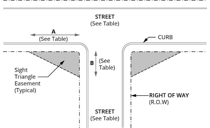
| Local Street | Collector | Arterial | |
|---|---|---|---|
| Private Drive - 15 | 40 | 20 | 20 |
| Local Street - 35 | 50 | 50 | 50 |
| Collector - 50 | 35 | 50 | 50 |
| Arterial - 50 | 35 | 50 | 50 |
1011 (c) Access easements.
Vehicular access may be provided from a public street via easement in any one or more of the following circumstances:
The property must be served by an exclusive access easement that shall be limited to the provision of access to only one principal use or structure on one lot.
1011 (d) Residential subdivision entrances.
1011 (e) Commercial/industrial subdivision entrances.
1011 (f) Driveways for multi-family and non-residential development projects.
Deceleration lanes and turn lanes.
Sec. 1012 - Deceleration lanes and turn lanes.
1012 (a) Deceleration and turning lanes; where required.
1012 (b) Median breaks.
If the street has an existing or proposed median, and the developer is approved by the County or Georgia DOT, as applicable, to construct a median break to serve the development, a left turn lane leading to the median break shall be provided by the developer meeting the design standards of the County.
1012 (c) Deceleration and turn lane constructions standards.
35 MPH and less roadways: 12 foot wide lane (exclusive of curb and gutter), 150 foot storage lane, with an additional 50 foot taper length.
40 MPH and greater roadways: 12 foot wide lane (exclusive of curb and gutter), 200 foot storage lane, with an additional 100 foot taper length.
Additional right-of-way to accommodate the deceleration lane or turn lane and a 12 foot shoulder shall be dedicated by the developer to the County.
Sidewalks.
Sec. 1013 - Sidewalks.
The Director of Douglas County Department of Transportation will have the authority to impose additional sidewalk requirements beyond what is specifically stipulated in this section. Sidewalks shall be installed according to County standards by the developer under the following circumstances:
Alternative compliance. The intent of the sidewalk requirements is to ensure that sidewalks are provided for public pedestrian use on all developed sites. Occasionally, this intent is better served in a different location within the county. To provide a viable alternative for such cases, the developer may be allowed to contribute to the Douglas County Sidewalk Fund with the concurrence of the Director of the Department of Transportation.
A report for the Douglas County Sidewalk Fund will be made available to the Board of Commissioners by the Finance Department as part of the County's annual audit.
Storm drainage.
Sec. 1014 - Storm drainage.
Systems and facilities for the conveyance and control of stormwater shall be designed, installed and maintained in accordance with the requirements adopted by the WSA, subject to the following County standards.
1014 (a) Stormwater pipes within streets.
Within public street rights-of-way or private street easements, the following shall apply:
1014 (b) Materials and installation.
| Corrugated Steel AASHTO M-36 | Corrugated Aluminum AASHTO M- 196 | Plastic AASHTO M- 294 Per Ga. DOT Standards | ||||
|---|---|---|---|---|---|---|
| Type of Pipe Installation | Reinforced Concrete Pipe (RCP) | Aluminized Type II CMP | Bituminous Coated CMP | Aluminum Alloy CMP | Corr. High Density Polyethylene Smooth Lined | Reinforced Concrete Box Culvert |
| LONGITUDINAL Grade less than 10% | YES | YES | YES | YES | See Note 1 | n/a |
| LONGITUDINAL Grade 10% or more | NO | YES | YES | YES | See Note 1 | n/a |
| CROSS DRAIN Local Street | YES | NO | NO | NO | NO | n/a |
| CROSS DRAIN Collector or Arterial St. | YES | NO | NO | NO | NO | n/a |
| CROSS DRAIN Flowing stream | YES | See Note 3 | NO | NO | NO | n/a |
| CROSS DRAIN 25 year flow >200 cfs Fill depth > 18 feet | See Note 2 | See Notes 2 & 3 | NO | See Note 2 | NO | YES |
Water supply.
Sec. 1015 - Water supply.
Fire hydrants.
Sec. 1016 - Fire hydrants.
Sanitary sewage disposal.
Sec. 1017 - Sanitary sewage disposal.
Location of utilities and street cuts.
Sec. 1018 - Location of utilities and street cuts.
1018 (a) Location of utilities in streets.
Street light poles, junction boxes, transformers and other public or private utility structures placed above ground within a public street right-of-way or private street easement must meet set-back criteria and clear zone distance criteria based on the latest edition of the Roadside Design Guide , by the American Association of State Highway and Transportation Officials, or at least 9 feet back from the back of the street curb (or edge of pavement) and 1 foot back from the edge of any sidewalk, whichever is farthermost from the roadway.
1018 (b) Utility Permits.
Overview—project construction.
Sec. 1019 - Overview—project construction.
1019 (a) Development activity.
Following the issuance of any permit authorizing clearing and grading of a site, areas required to be undisturbed, such as natural zoning buffers or stream buffers, must be designated by survey stakes, flags, ribbon, or other appropriate markings and shall be inspected and approved by the Development Services Department prior to the commencement of any clearing or grading activities.
Performance and Maintenance bonds in accordance with Section 1027 shall be submitted prior to obtaining a Development Permit as deemed necessary by the Director of the Department of Transportation where construction activity related to any project could possibly damage County roads. The amount of the aforementioned bond shall be determined by the Director of the Department of Transportation.
1019 (b) Development phase inspections.
Requests for inspections shall be made by the owner or contractor to the Development Services Department at least 24 hours prior to when the inspection is needed. Inspections shall be made and passed prior to continuation of further activity or proceeding into new phases. Inspections are required of each of the following phases, as applicable to the actual work to be performed under the development permit:
1019 (c) As-built surveys.
1019 (d) Final development inspection.
1019 (e) Bonds.
Prior to approval of a final subdivision plat or issuance of a certificate of occupancy, a maintenance bond and/or performance bond in a form acceptable to the Development Services Department is required for all public improvements shown on the as-built surveys. Any required bond shall be with a company licensed to do business in the State of Georgia and included on the United States Department of Treasury's list of acceptable sureties. For details see the Procedures and Permits Article of this Development Code regarding acceptance of public improvements.
Site clearing and grading.
Sec. 1020 - Site clearing and grading.
1020 (a) Development permit required.
See the Procedures and Permits Article of this Development Code for details.
1020 (b) Erosion and sedimentation control measures.
Required erosion and sedimentation control measures must be installed in accordance with the approved soil erosion and sedimentation control plan prior to any major development activity and as development progresses.
1020 (c) Stormwater drainage facilities.
Required stormwater drainage facilities are to be installed in accordance with the approved stormwater management plan as development progresses.
1020 (d) Clearing and grubbing.
The entire area within the typical grading section shall be cleared and grubbed of all trees, bushes, stumps and debris. Such debris shall be disposed of in a lawful manner.
1020 (e) Earthen embankments.
Earthen embankments shall be placed in uniform layers not to exceed a compacted thickness of 6 inches per layer and shall be compacted to a density of 95 percent of the maximum laboratory dry weight per cubic foot as determined by AASHTO Method T-99 in all areas where structures, parking lots and drives, streets, and utilities are to be placed; all roadway embankments must be 100% compacted within the top 1 foot. If necessary in order to obtain this compaction, the contractor shall add moisture to the material as it is placed. All other embankments are to be compacted to at least 90 percent.
Floodproofing shall be accomplished prior to placement of embankments to detect soft spots.
1020 (f) Slopes.
| Depth of Cut or Fill | Cut Slopes* | Fill Slopes* |
|---|---|---|
| 2 feet or less | 2 to 1 | 2 to 1 |
| 2 feet to 5 feet | 2 to 1 | 3 to 1 |
| Over 5 feet | 2 to 1 | 2 to 1** |
Director.
_____ **Guardrails required (see Standard Details).
_____
Excavating and trenching.
Sec. 1021 - Excavating and trenching.
1021 (a) Definitions related to excavating and trenching.
The following words, terms and phrases, when used in this Article, shall have the meanings ascribed to them in this Section, except where the context clearly indicates a different meaning:
Excavation: (1) The mechanical removal of earth material. (2) Any manmade cavity or depression in the earth's surface, including its sides, wall, or faces, formed by earth removal and producing unsupported earth conditions by reasons of the excavation. If installed forms or similar structures reduce the depth-to-width relationship, an excavation may become a trench.
Excavation and trenching certificate: The certificate issued upon satisfactory completion of a mandatory training/educational program regarding excavation and trenching safety practices, such program to be provided by or approved by the Douglas County Fire Department.
Excavation and trenching certificate holder: The holder of the "excavation and trenching certificate"
identified above.
OSHA: The U.S. Department of Labor, Occupational Safety and Health Administration, or successor agency.
Trench: A narrow excavation made below the surface of the ground. In general, the depth is greater than the width, but the width of a trench is not greater than 15 feet.
1021 (b) Unauthorized excavating and trenching prohibited.
No individual, partnership, corporation, or other entity of any kind whatsoever shall engage in any excavation or trenching except in compliance with the provisions of this Section and in compliance with any applicable laws of the State of Georgia or of the United States or the Occupational Safety and Health Administration (OSHA), or any other state or federal governmental entity or department rules and regulations applicable to excavating and trenching.
1021 (c) Adoption of OSHA safety and health regulations.
All safety and health regulations adopted by OSHA with regard to excavating and trenching operations, particularly part 1926, Subpart P—Excavations, Trenching, and Shoring Section 1926.650, 1926.651, 1926.652, 1926.653 of the Code of Federal Regulations, as the same now exist or may be hereafter amended, are adopted as a part of this Development Code as if quoted verbatim herein.
1021 (d) Excavation and trenching certificate required.
Douglas County will honor excavation and trenching certificates issued by other agencies if such agencies can satisfactorily show proof that their training/educational program meets or exceeds the Douglas County program regarding excavation and trenching safety practices.
1021 (e) Permit required.
1021 (f) Enforcement of excavating and trenching requirements.
The violation of any laws or ordinances regulating excavating or trenching as set forth hereinabove shall constitute due cause for suspending or revoking such permit. Three days notice shall be deemed reasonable, but shorter or longer periods of notice shall be authorized as the board of commissioners may deem appropriate. At such hearing, the permit holder shall be entitled to be represented by an attorney, to cross-examine all witnesses who may appear against him, and to present evidence in his own behalf.
1021 (g) Inspection by Douglas County.
The director of the department of emergency management or his or her designated representative is authorized to periodically inspect trench/excavation sites during all reasonable hours, or outside reasonable hours in the event of any emergency threatening life or property. Such inspectors shall, among other things, verify the presence of the required permits, the existence of required excavation and trenching certificates and compliance with OSHA safety standards hereinabove adopted. Should access to any site be denied by the owner or other person having charge or control of the site, in the absence of any emergency threatening life or property, the director of the department of emergency management or his or her designated representative is authorized to obtain an inspection warrant pursuant to Article 14, Section 1410(b) of this Code.
1021 (h) Violations.
In addition to the provisions of the Administration and Enforcement Article of this Development Code, the following shall apply to violations under this Section:
Installation of stormwater drainage facilities.
Sec. 1022 - Installation of stormwater drainage facilities.
1022 (a) Timing of installation.
Construction of the stormwater system shall be initiated as part of the grading of the site. Storm water detention facilities shall be constructed prior to the installation of any other site improvements, and may be utilized under proper design as sedimentation basins during development. Installation of all other storm drainage pipes, culverts, headwalls, and ditches, shall be coordinated with the construction of streets and other site improvements, as appropriate, in accordance with a Stormwater Management Plan approved by the WSA.
1022 (b) Maintenance responsibilities.
Installation of streets and utilities.
Sec. 1023 - Installation of streets and utilities.
All streets shall be installed and inspected in accordance with this Section, whether public or private.
1023 (a) Grading.
1023 (b) Installation of utilities; general.
1023 (c) Installation of public water and sewerage systems.
The standards, procedures and other requirements of the Douglasville-Douglas County Water and Sewer Authority shall be followed for the installation of public water supply and distribution facilities, and for the installation of public sanitary sewer facilities 1023 (d) Street installation.
Street base, curbing and paving shall be installed by the developer in accordance with the requirements and standards of this Development Code.
1023 (e) Testing requirements; streets.
| Table | 10.6: Testing Requirements | |
|---|---|---|
| Type of Test to be Performed | Minimum Number of Tests | Testing Standards |
| Sub-grade Compaction | Each 1,500 linear feet of roadway (at least 1 per street) | 100% Max Density |
| Base Compaction | Each 1,500 linear feet of roadway (at least 1 per street) | 100% Max Density |
| Asphalt Content and Gradation— Intermediate | For each lane, 1 test per 3,400 linear feet, minimum 1 per road | GDT 83 or GDT 125 and GDT 38 |
| Asphalt Content and Gradation— Surface | For each lane, 1 test per 5,000 linear feet, minimum 1 per road | GDT 83 or GDT 125 and GDT 38 |
| Mix Temperature* | As deemed necessary | |
| Laydown Rate* | 1 per 1,000 linear feet, minimum 1 per road | |
| Pavement Density | For each lane, 1 per 1,000 linear feet, minimum 2 per road | GDT 59 |
| Lift Thickness and Base Thickness with Coring and Augering** | For each lane, 1 per 1,000 linear feet, minimum 2 per road |
_____
| Type of Test to be Performed | Minimum Number of Tests | Testing Standards |
|---|---|---|
| Sub-grade Compaction | Each 1,500 linear feet of roadway (at least 1 per street) | 100% Max Density |
| Base Compaction | Each 1,500 linear feet of roadway (at least 1 per street) | 100% Max Density |
| Asphalt Content and Gradation— Intermediate | For each lane, 1 test per 3,400 linear feet, minimum 1 per road | GDT 83 or GDT 125 and GDT 38 |
| Asphalt Content and Gradation— Surface | For each lane, 1 test per 5,000 linear feet, minimum 1 per road | GDT 83 or GDT 125 and GDT 38 |
| Mix Temperature* | As deemed necessary | |
| Laydown Rate* | 1 per 1,000 linear feet, minimum 1 per road | |
| Pavement Density | For each lane, 1 per 1,000 linear feet, minimum 2 per road | GDT 59 |
| Lift Thickness and Base Thickness with Coring and Augering** | For each lane, 1 per 1,000 linear feet, minimum 2 per road |
Building construction.
Sec. 1024 - Building construction.
1024 (a) Building permit required.
1024 (b) Building inspection.
Inspections shall be scheduled with the Building Inspector before the inspection is needed.
Requests for inspection should include the street address, lot number, building permit number, and type of inspection.
1024 (c) Certificate of occupancy required.
A Certificate of Occupancy must be issued prior to the occupancy or use of any new or newly renovated building or structure, in accordance with the Procedures and Permits Article of this Development Code.
Dams.
Sec. 1025 - Dams.
The provisions of O.C.G.A. 12-5-370 "Georgia Safe Dams Act of 1978", all applicable federal and state laws, and administrative rules and regulations shall apply to all dams located in Douglas County.
Any person who desires to construct a dam shall be required to obtain a permit from the Georgia Environmental Protection Division and the owner(s) of all dams shall operate and maintain existing dams as per regulations set forth in the act. In the event proposed development(s) could be effected by existing dams located on-site or upstream as determined by the Development Services Director or his/her designee, prior to issuance of a Land Disturbance Permit the developer shall provide a detailed engineering analysis, including but not limited to a dam breach analysis, hydraulic and hydrologic evaluations, which shall be performed by a professional engineer licensed by the State of Georgia and any geological investigations are required to be performed by a professional geologist registered to practice in the State of Georgia demonstrating the dam is sufficient to protect against probable loss of human life and/or property damage downstream. Such analysis and evaluation shall find the dam to be in a safe and stable condition, with no forseeable deterioration in condition or safety.
1025 (a) Permanent pool impoundments.
Douglas County Dam Regulations shall apply to all new, rebuilt, or modified stormwater impoundments, including appurtenant works, with the exception of:
All new dams of 25 vertical feet in height (or greater), impoundments containing a maximum storage volume of at least 100 acre-feet, or dams which have been ruled Category II by the Safe Dams Program shall be designed and constructed according to Category I Spillway Standards, as promulgated by the Safe Dams Program under the direction of a Georgia Licensed Civil Engineer and a Georgia Licensed Geotechnical Engineer, both experienced in the design and construction of dams. All dam heights will be measured from the streambed at the downstream toe to the top of dam.
Prior to construction of any dam over 15 vertical feet or any dam impounding more than 50 acre-feet, the contractor shall provide to Douglas County sufficient documentation of his/her qualifications to construct dams.
A pre-design meeting shall be held with representatives of the Development Services Department, to review any proposed dam or proposed dam changes for any dam over 15 vertical feet or impounding more than 50 acre-feet.
Residential or commercial structures may not be constructed or re-constructed on any dam and may not be constructed within the limits of the flood failure zone of any dam. Douglas County must be satisfied that a dam failure will not result in a probable loss of life downstream.
Depending on the level of downstream risk and size of impoundment, Douglas County may require a dam breach analysis to be submitted for any proposed or existing dam impacting a proposed development, utilizing the National Weather Service's DAMBREAK Program or other methodology approved by the Georgia Safe Dams Program. A DAMBRK analysis will be required for all Category I and II dams. When a dam breach analysis is required by Douglas County, as a minimum a sunny day dam breach analysis shall be performed under full pool conditions.
Guidelines are available from the State of Georgia Safe Dams Program (EPD) to assist the design/construction professional. Dam design documents shall include, but not be limited to:
Dam = Plan view = Sections at all critical points = Details, complete;
Because of the variables associated with selecting spillway(s), outlet device(s) or appurtenant structure(s) to suit a given site condition, the design consultant is responsible for the selection, subject to the review and approval of the Development Services Department. The Development Services Department will include in its consideration the ease of maintenance, longevity of the system, blockage potential, and practicality of operations.
No orifice shall be less than 3 inches in diameter unless it is installed to meet a State or local requirement.
All risers (standpipes) shall be equipped with a debris deflector (trash rack) and an anti-vortex device. To facilitate outlet operation, curved or inclined trash racks designed to allow debris to rise with the water level are preferred. In all cases, trash racks shall be either hinged or removable to facilitate maintenance operations. Corrugated metal pipe is not permitted for standpipes.
Spillways: Every dam shall be provided with a principal spillway, fully capable of passing at least the 50-year flood, with excess spillway capacity provided by the emergency spillway(s) capable of handling excess flows up to the design storm. The principal spillway can be sized for floods of less magnitude than the 50-year flood only if the emergency spillway is appropriately armored against scour with concrete or other suitable lining as protection against more frequent usage.
Principal spillway: All spillways shall be analyzed (hydraulically rated) for both inlet and outlet control conditions using appropriate tailwater ratings. If a control-box or weir-box is affixed, then the total system (inlet control box and outlet conduit) shall be hydraulically rated to determine the stage-discharge relationship.
Emergency spillway(s): For every type of water impounding facility, a planned safe flow path must be provided for conveyance of flows of water in an emergency. In many instances, this function can be provided through installation of an emergency spillway. Emergency spillways may be excavated open channels, either vegetated or paved with reinforced concrete, weir sections of concrete walls, or appropriately designed conduit.
Any portion of an open channel spillway excavated into a dam embankment or other fill section must be paved with reinforced concrete equipped with appropriate seepage controls, underdrainage, and cut-off walls.
Any portion of any spillway excavated into undisturbed residual soil shall be vegetated in accordance with the practices described in the "Manual for Erosion and Sediment Control in Georgia" or protected against scour and erosion by other suitable measures if vegetation does not provide adequate stabilization. If the spillway is activated by storms smaller than the 50-year frequency, then vegetation alone will not be considered sufficient protection against scour according to these standards.
A 12-foot combined drainage and permanent access easement shall be established around the pond at the 100-year pool level or at the elevation of top of dam, whichever is greater to provide access and permanently prevent usage or modification of this flood storage area. A 12-foot combined easement shall also be provided along the toe of the dam. A 20-foot access easement from the public right of way shall be provided.
Emergency draining of the lake: Upon obtaining evidence which indicates that a potentially hazardous condition may exist, such as:
The County Administrator has the authority to order the immediate and complete draining of the lake in whatever manner deemed necessary at the time and to require the owner to keep the pool down until remedial work, as is deemed most appropriate to create a safe dam condition, is completed and approved by the Development Services Department.
All lakes shall have a permanent lake drain.
No public roadways shall be constructed over any permanent water impoundment structure.
Private roadways and driveways over any permanent impoundment structure (including full indemnification to the County) shall be reviewed on a case-by-case basis by the County Administrator (access for public safety vehicles must be addressed in said indemnification).
No utilities are permitted to pass through any dam, either longitudinally or transversely, unless approved by the Development Services Department.
(Dams with vertical heights less than or equal to 6 feet.)
Any earthfill dam equal to or less than 6 feet in height is an exempt structure according to Georgia Safe Dams Act. The following minimum design criteria shall apply:
Design and construction supervision must be performed by civil engineer licensed to practice in the State of Georgia. Construction verification checklist to be submitted to the Development Services Department;
Design shall address and account for overturning, sliding uplift, and seepage with adequate safety factor (2.0 for over-turning, 1.5 for sliding) and adequate freeboard (0.5 feet above 100-year pool). Steel design shall conform to American Concrete Institute Code. Uplift loads can be reduced by 70%, if an under-draining system is provided. Construction verification checklist must be provided by design engineer or approved alternate. Design storm shall be at least SCS 24-hour 100-year event or equivalent approved the Development Services Department.
(Dams with vertical heights between 6 and 25 feet with less than 100 acre-feet of storage)
Design, construction supervision, and certification of completion according to plans and specifications to be by civil engineer and a geotechnical engineer both licensed to practice in the State of Georgia.
Design shall conform to the requirements of a Category I Spillway Standards Dam as classified by the Georgia Safe Dams Office and as published in "Georgia Safe Dams Act and Rules for Dam Safety," Act No. 796, as amended to date.
Design storm shall be at least 25% of the Probable Maximum Precipitation (6-hour) storm event.
Principal spillway shall be adequate to handle at least the 50-year flood. Emergency spillway(s) as a minimum shall be adequate to handle flows in excess of the 50-year flood, up to the ¼ PMP.
Front and back slopes shall not be steeper than 3:1 unless design includes a slope stability analysis, which confirms and documents that a steeper slope will be stable. In no condition, however, will a slope steeper than 2:1 be permitted.
All organics and topsoil shall be removed from the entire footprint of the dam and the foundation certified by a geotechnical engineer (PE).
Earthen fill shall be CL or ML material approved for use by geotechnical engineer (PE), placed, and compacted to not less than 95% standard proctor under said engineer's direction.
Compaction records accompanied by a geotechnical engineer's certification that soil compaction meets this specification should be forwarded to the Development Services Department.
The low-level outlet (lake drain) shall be concrete pressure pipe or ductile iron pressure pipe, cradled in concrete. Bedding shall be in concrete poured the full width of the exposed trench and as a minimum, up to the spring line of the pipe. Pipe and joints shall be rated for internal pressures exceeding that of the design storm and shall meet or exceed ASTM 361 or AWWA C-301. Corrugated metal pipe is not allowed.
A lake drain may also be comprised of a valve-operated siphon system designed by a registered civil engineer licensed in the State of Georgia. Piping for a siphon system shall be schedule 80 PVC in conformance with current state standards or ductile iron with mechanical joints or PV joints with adequate strength and anchoring to sustain the water forces incumbent with operation.
Freeboard of a dam, above the design storm maximum pool, shall be 3.0 feet in lieu of fetch calculations of wave height justifying a lesser freeboard. Douglas County reserves the right to require additional freeboard above the nominal 3-feet requirement, if supported by fetch calculations.
Crest width shall be not less than 12.0 feet.
Design, construction supervision, and certification of completion according to plans and specifications to be by design civil engineer and a geotechnical engineer both licensed to practice in the State of Georgia.
Design shall address and account for overturning, uplift, and seepage with adequate safety factory and adequate freeboard.
All slab on grade concrete, including concrete footings, shall be designed and constructed to control seepage and piping of foundation soil along the underside of the slab in incorporating cutoff walls or other appropriate measures.
Design storm shall be as specified by the Development Services Department. Generally, at least 25% of the Probable Maximum Precipitation 6-hour storm event (¼ PMP) is required.
Principal spillway shall be adequate to handle at least the 50-year flood unless the emergency spillway is appropriately armored against scouring.
Emergency spillway shall be adequate to handle flows in excess of the 50-year flood, up to the 6-hour PMP.
Freeboard of a dam, above the design storm maximum pool, shall be 3.0 feet in lieu of fetch calculations of wave height justifying a lesser freeboard. Additional freeboard above the nominal 3 feet required, if supported by fetch calculations.
Design shall conform to the requirements of a Category I Spillway Standards Dam as classified by the Georgia Safe Dams Office and as published in "Georgia Safe Dams Act and Rules for Dam Safety," Act No. 796, as amended to date.
All organics and topsoil shall be removed from the entire footprint of the dam and the foundation certified by a geotechnical engineer (PE).
Earthen fill (if any) shall be subject to the criteria specified above for earthen embankments.
Required 28-day compressive strength for concrete is 3000 psi.
1025 (b) Temporary pool impoundments.
Normally dry stormwater storage basins - impound stormwater temporarily, i.e., dry detention ponds.
Design to be by registered civil engineer licensed to practice in the State of Georgia.
Detention pond dams equal to or greater than 15 feet in height or greater than 50 acre-feet of storage must conform to the corresponding design criteria for permanent impoundments, as referenced above.
(The following criteria apply to dry detention pond dams less than 15 feet high and less than 50 acre-feet).
A 12-foot combined easement shall also be provided along the toe of the dam. A 20-foot access easement from the public right of way shall be provided.
Front slope shall not be steeper than 2.5:1 unless design includes a slope stability analysis, which confirms and documents that a steeper slope will be stable. In no condition, however, can any slope be steeper than 2:1.
All organics and topsoil shall be removed from the entire footprint of the dam and the foundation inspected and approved by the geotechnical licensed, qualified engineer prior to fill placement.
Earthen fill shall be CL or ML material approved for use by a geotechnical engineer (PE) and placed and compacted to not less than 95% Standard Proctor under said engineer's direction.
Freeboard of a dam, above the 100-year design storm maximum pool, shall be 2.0 feet in lieu of fetch calculations of wave height justifying a lesser freeboard. Douglas County reserves the right to require additional freeboard above the nominal two feet requirement, if supported by fetch calculations.
Crest width shall be not less than 12.0 feet, unless approved by the Development Services Department.
Proprietary design products may be considered on a case-by-case basis.
Design shall address and account for overturning, uplift, and seepage with adequate safety factor (2.0 for overturning, 1.5 for sliding) and adequate freeboard (0.5 feet above 100-year).
Steel design shall conform to American Concrete Institute Code. Uplift loads can be reduced by 70%, if an underdraining system is provided. Construction verification checklist must be provided by design engineer or approved alternate.
All slab on grade concrete, including concrete footings, shall be designed and constructed to incorporate appropriate cutoff walls.
In no condition can any fill slope (if any) be steeper than 2:1.
All organics and topsoil shall be removed from the entire footprint of the dam and the foundation inspected and approved by the Development Services Department prior to gravity dam concrete or masonry placement.
Earthen fill (if required) shall be approved for use by a geotechnical engineer (PE) and placed and compacted to not less than 95% Standard Proctor under said engineer's direction.
Freeboard of a dam, above the 100-year design storm maximum pool, shall be 2.0 feet along any earthfill sections of the dam, in lieu of fetch calculations of wave height justifying a lesser freeboard. Douglas County reserves the right to require additional freeboard above the nominal two feet requirement, if supported by fetch calculations. Freeboard for the concrete section of the dam shall be a minimum of 0.5 feet.
Required 28-day compressive strength for concrete is 3000 psi.
Outdoor lighting.
Sec. 1026 - Outdoor lighting.
1026 (a) Conformance with applicable regulations.
All outdoor lighting devices must comply with the provisions of this division, the building code and the electrical code, required permits and inspections, as applicable.
1026 (b) Prohibited lighting.
1026 (c) Exempt lighting.
The following luminaries and lighting systems are expressly exempt from the regulations of this division:
1026 (d) Regulations.
| At Property Lines Including Rights-of-Way | Maximum Footcandles |
|---|---|
| At property line abutting a residential or an agricultural use | 0.5 |
| At property line abutting an office or institutional use | 1.0 |
| At property line abutting a commercial or industrial use | 1.5 |
| Off-Street Parking Lots | Minimum Footcandles | Average Footcandles | Maximum Footcandles |
|---|---|---|---|
| Residential areas | 0.5 | 2.5 | 4.0 |
| Office-professional areas | 1.0 | 3.5 | 6.0 |
| Commercial areas | 2.0 | 7.0 | 12.0 |
| Industrial areas | 1.0 | 5.0 | 8.0 |
This subsection establishes supplemental lighting regulations for specific types of uses and activities. All lighting not directly associated with the special use areas designated below must comply with all other applicable regulations of this division.
1026 (e) Plans.
The description may include, but is not limited to catalog cuts and illustrations by manufacturers.
Bond requirements.
Sec. 1027 - Bond requirements.
At this time the Development Services Director or his/her designee shall either:
Road, alley or easement vacation.
Sec. 1028 – Road, alley or easement vacation.
Under Article 1, Section 105(c)(6) – Authority to Dispose of Property, whenever deemed in the public interest, the Director of Transportation may accept a petition to substitute for, relocate, or abandon public road or alley right-of-way or public easements under the procedures provided in Article 12 of this Unified Development Code.