LandCode
Johns CreekCode of Ordinances — Subpart B (Land Development Regulations)

Chapter 113 — Development Regulations

current as of 2025-09-08currency checked manuallyOfficialVerify with City of Johns Creek76 sections · full chapter
§ 113-1

Authority and title.

Sec. 113-1. Authority and title.

(1)These rules and regulations are adopted under the authority of the Constitution of the State of Georgia and laws enacted pursuant thereto.
(2)These regulations shall be known as "The City of Johns Creek Development Regulations" and may be referred to generally as "The Development Regulations," or, as used herein, "these regulations." (Ord. No. 2009-06-18, (1.1), 6-29-2009)
§ 113-2

Purpose.

Sec. 113-2. Purpose.

(1)These regulations are intended to serve the following purposes:
a.To protect and promote the public health, safety, and general welfare.
b.To provide a system for the development of lands and the accurate recording of land titles.
c.To provide assurance that lots shown on recorded subdivision plats are usable by the purchasers for their intended and permitted functions.
d.To encourage economically sound and orderly land development in accordance with the policies and objectives of the comprehensive plan and other applicable regulations.
e.To assure the provision of required streets, utilities, and other facilities and services to new land developments in conformance with public improvement policies of the city.
f.To assure adequate provision of safe and convenient traffic access and circulation, both vehicular and pedestrian, in new land developments.
g.To assure the provision of needed open spaces and public facility sites in new land developments through the dedication or reservation for purchase of land for public purposes.
h.To assure equitable review and approval of all subdivision and other development site plans by providing uniform procedures and standards for the developer/subdivider.
(Ord. No. 2009-06-18, (1.2), 6-29-2009)
§ 113-3

Intent and application.

Sec. 113-3. Intent and application.

These regulations apply to and provide guidance for the development of any lands within the city, whether the development involves the subdivision of the land for sale to individual users or pertains only to the construction of buildings or other improvements on a single parcel. (Ord. No. 2009-06-18, (1.3), 6-29-2009)

Secs. 113-4—113-10. Reserved.

ARTICLE II. ADOPTION AND AMENDMENT
§ 113-11

Effective date and amendments.

Sec. 113-11. Effective date and amendments.

(1)These regulations shall be in full force and effect on (insert date), following the adoption by the city council and shall apply to any land disturbance permit for which an application is received after the effective date of these regulations.
(2)These regulations may be amended from time-to-time by ordinance of the city council. Such amendments shall be effective as of their date of adoption unless otherwise stated in the adopting ordinance.
(3)Any subdivision or other development for which a valid and complete application for a land disturbance permit shall have been received prior to the effective date of or the adoption of an amendment to these regulations shall be considered "grandfathered" and, at the developer's option, may proceed to completion and building permits may be issued under the applicable regulations of the city which were in place prior to the effective date of or the adoption of an amendment to these regulations.
(4)Any subdivision or other development for which a land disturbance permit has been issued prior to the effective date of or the adoption of an amendment to these regulations shall be considered "grandfathered" and, at the developer's option, may proceed to completion and building permits may be issued under the terms of said permit and the applicable regulations of the city which were in place prior to said effective date.
(5)Any subdivision or other development for which a modified or conditional land disturbance permit may have been issued, including, but not limited to, any permit which may have been issued for clearing and grubbing or grading only purposes, prior to the effective date of or the adoption of an amendment to these regulations shall be brought into conformance with these regulations prior to issuance of any other land disturbance permit or permit revision that would authorize additional work on the project. Administrative modifications in accordance with article III may be granted as necessary and appropriate where full compliance is not feasible or cannot reasonably be achieved because of the stage of development, limitations imposed by the site, or design parameters.
(6)Nothing in these regulations shall be construed to affect the validity of any building permit lawfully issued prior to the effective date of these regulations.
(7)No amendment to these regulations shall be construed to affect the validity of any building permit lawfully issued prior to the adoption of said amendment. (Ord. No. 2009-06-18, (2.1), 6-29-2009)
§ 113-12

Severability.

Sec. 113-12. Severability.

If any section, subsection, sentence, clause, or phrase of these regulations is for any reason held to be unconstitutional or void, the validity of the remaining portions of these regulations shall not be affected thereby, it being the intent of the city council in adopting these regulations that no portion thereof or provision of the regulations contained herein shall become inoperative or fail by reason of the unconstitutionality or invalidity of any section, subsection, sentence, clause, phrase, or provisions of these regulations. (Ord. No. 2009-06-18, (2.2), 6-29-2009)

§ 113-13

Conflicting regulations.

Sec. 113-13. Conflicting regulations.

All regulations or parts of regulations of this Code of the City of Johns Creek, Georgia, in conflict with these regulations shall be and the same are hereby repealed in their portions so in conflict. Provided, however, that it is not the intent of these regulations to repeal or affect any Law of the State of Georgia or any Code or Ordinance of the City of Johns Creek, Georgia adopted as a requirement of a state law, in which case the most restrictive requirement shall control. (Ord. No. 2009-06-18, (2.3), 6-29-2009)

Secs. 113-14—113-20. Reserved.

ARTICLE III. ADMINISTRATION, APPEAL, AND VIOLATIONS
§ 113-21

Administration.

Sec. 113-21. Administration.

(1)Administration of the development regulations.
a.These development regulations shall be administered, interpreted, and enforced by the director of community development except where specifically noted otherwise. It is the intent of these regulations that the requirements provided in article XI and article XII shall be interpreted by the public works director and any modifications to these articles shall only be made with the approval of the public works director or other governing body authorized to approve waivers or variances to these regulations. All other ordinances or regulations referenced herein, such as the fire prevention and life safety codes, building and other technical codes, health, water, and sewer regulations, shall be administered by the directors of the departments responsible for such regulations, as established by the mayor and city council.
b.Prior to the initiation of any application pursuant to these development regulations, the director is authorized to require the applicant to supply such information and documentation, and complete such applications and checklists, as deemed reasonably necessary to insure compliance with the terms and conditions of these development regulations.
(2)Work in violation of regulations. In any case in which activities are undertaken in violation of these regulations, not in compliance with the provisions of a permit issued under the authorization of these regulations, or without authorization of a permit which would otherwise be required, the director is hereby authorized to suspend or invalidate such permits, order that all unauthorized or improper work be stopped, direct correction of deficiencies, issue citations/summonses to the city municipal court, or take any other legal or administrative action appropriate to the severity of the violation and degree of threat to the public health, safety, and welfare.
(3)Regulations to be published. It shall be the duty and responsibility of the city clerk to maintain an accurate and up-to-date compilation of these development regulations and all amendments and pertinent attachments thereto and to publish said compilation and make it available to the public at a cost as established by the city council.
(4)Modifications. Modification of the design standards set forth in these development regulations and defined in articles XI and XII may be authorized by the public works director, or article XIII by the director of community development, in specific cases when, in his/her opinion, undue hardship may result from strict compliance; provided any such determination shall be based fundamentally on the fact that unusual topographical or other exceptional conditions require such modification, or that the granting of the modification will not adversely affect the general public welfare or nullify the intent of these regulations. Any such modification granted by the director shall be made in writing to the applicant and also made a part of the department's records. Application for any modifications shall be filed in writing on a form provided by the department with necessary supporting documents with the director by the applicant and shall explain in detail the reasons and facts supporting the application. Any denial of administrative modification by the director shall be appealable pursuant to section 113-22 of these regulations. (Ord. No. 2009-06-18, (3.1), 6-29-2009)
§ 113-22

Appeals and variances to the regulations.

Sec. 113-22. Appeals and variances to the regulations.

(1)Appeals. All appeals shall be filed pursuant to article XXII of the city zoning ordinance.
(2)Variance. Variance requests to the requirements of these regulations, or appeals of the director's decisions, shall be submitted on an application form as prescribed by the director, along with such fees as shall be established by the city council. The director shall coordinate the review of each variance request with all other affected city departments and shall summarize such comments or recommendations as may be received to the board of zoning appeals for action in their normal course of business.
(3)Judicial review. Any person aggrieved by a decision or order of the city, after exhausting his administrative remedies, shall have the right to appeal by application for writ of certiorari to superior court. Any appeal of a decision of the city shall be made within 30 calendar days of the date of the decision. (Ord. No. 2009-06-18, (3.2), 6-29-2009)
§ 113-23

Violations and enforcement.

Sec. 113-23. Violations and enforcement.

Any action or inaction that violates the provisions of these regulations or the requirements of an approved plan or permit shall be subject to the enforcement actions or penalties outlined herein. Any such action or inaction that is continuous with respect to time is deemed to be a public nuisance and also may be abated by injunctive or other equitable relief. The imposition of any of the enforcement actions or penalties described herein shall not prevent such equitable relief.

(1)Enforcement procedures. The following are the enforcement procedures authorized by this chapter:
a.Notices of violation enforcement.
1.Enforcement actions may begin with the issuance of a written notice of violation to the owner or responsible person by the director. The notice may be delivered personally, sent by first class mail, or posted onsite. The notice of violation shall contain at least the following information:
i.The name and address of the owner or responsible person;
ii.The location or address of the site upon which the violation is occurring;
iii.A description of the nature of the violation;
iv.A description of the remedial actions or measures necessary to bring an action or inaction into compliance with a permit, approved plan or these regulations;
v.The deadline or completion date of any such remedial actions or measures; and
vi.A statement of the penalty or penalties that maybe assessed against the owner or responsible person to whom the notice of violation is directed.
2.In the event the owner or responsible person fails to correct the violations after the deadline contained in the notice of violation. Nothing stated in this section shall limit the director's authorization to take or impose any one or more of the additional actions contained herein.
b.Stop work orders. The director is authorized to issue stop work orders to an owner or responsible person. Stop work orders are effective immediately and shall remain in effect until the necessary corrective actions or remedial measures as set forth in the notice of violation have occurred. stop work orders may be withdrawn or modified by the director in order to enable an owner or responsible person to take necessary remedial actions or measures to correct the violations. When it is deemed necessary for the protection of the safety, health or welfare of the general public an immediate stop work order may be issued without the issuance of a notice of violation. In such cases the stop work order shall define the necessary corrective actions or remedial measures as would have been provided in the notice of violation.
c.Refusal to issue certificates of occupancy or completion. The director is authorized to refuse to issue certificates of occupancy or completion for the building or other improvements constructed or being constructed on a site until the owner or responsible person has taken the remedial actions or measures as set forth in the notice of violation or has otherwise corrected the violations described therein.
d.Suspension, revocation, or modification of permit. The director is authorized to suspend, revoke or modify a permit that was issued authorizing land disturbing activities or development. The director is authorized to reinstate a suspended, revoked or modified permit after the owner or responsible person has taken the remedial actions or measures stated in the notice of violation or have otherwise corrected the violations described therein. The director is also authorized to reinstate such permit, which may include conditions as the director may deem necessary, to enable the owner or responsible person to take the necessary remedial actions or measures to correct the violations.
e.Refusal to approve final subdivision plats. The director is authorized to refuse to approve final plats until the owner or responsible person has taken the remedial actions or measures set forth in the notice of violation or have otherwise corrected the violations described therein.
f.Issuance of citations or summons to court. The director is authorized to issue a citation or summons to the owner or responsible person for violating any provision of these regulations, requiring such person to appear in the city municipal court.
(Ord. No. 2009-06-18, (3.3), 6-29-2009)

Secs. 113-24—113-40. Reserved.

ARTICLE IV. DEFINITIONS
§ 113-41

Use of words and interpretation.

Sec. 113-41. Use of words and interpretation.

(1)For the purposes of these regulations, the following shall apply to the use of all words:
a.When appropriate to the context, words used in the singular shall include the plural, and the plural the singular; words used in the present tense shall include the future tense, and vice versa.
b.Words in the masculine gender shall include the feminine.
c.The word "shall" is mandatory and not discretionary.
d.The word "may" is permissive.
e.Use of the word "and" is inclusive and requires that all of the component phrases so connected must be present or fulfilled for sufficiency.
f.Use of the word "or" is not exclusive (as in" either ... or"), and requires that at least one of the component phrases so connected must be present or fulfilled for sufficiency. The word "or" may allow more than one component phrase to be present or fulfilled, as is implied by the common term "and/or."
(2)The following shall control the interpretation of words and phrases as used in these regulations:
a.Words and phrases defined in this article shall be interpreted as defined herein.
b.Words or phrases not defined herein shall be interpreted as defined in the city's zoning ordinance, soil erosion and sediment control, buffer, tree preservation, floodplain, stormwater, or other applicable city ordinance, or the latest illustrated book of development definitions as applicable to the use of the word within the context of these regulations.
(Ord. No. 2009-06-18, (4.1), 6-29-2009)
§ 113-42

Definitions of words and phrases.

Sec. 113-42. Definitions of words and phrases.

Certain words or phrases in these regulations are defined for their use herein as follows:

AASHTO. The American Association of State Highway Transportation Officials.

Alley or service drive. A minor permanent, public service-way which is used primarily for vehicular service access to the back or the side for properties otherwise abutting on a street.

Access improvement. Any improvement or facility that is planned and designed to provide service or access for a particular project and which is necessary for the use and convenience of the occupants or users of the project and is not a system improvement. A project access improvement includes but is not limited to: pedestrian access improvements; site driveways; new streets; median cuts; right turn lanes, left turn lanes, acceleration lanes, and deceleration lanes made necessary to serve site driveways or new streets leading to or from the project;

traffic control measures made necessary to serve site driveways or new streets; intersection improvements whose primary purpose at the time of construction is to provide access to the project; and, necessary right-of-way dedications required for any project access improvement.

Applicant. A person, either the owner or the bona fide representative of the owner of land or structures governed by these regulations, who seeks authority to use, develop, construct upon or otherwise enjoy the use of property through any of the procedures established under these regulations.

Arterial. A principal arterial, major arterial, or minor arterial street as defined and designated in the comprehensive plan of the city.

"As-built" survey. See "Public record drawing".

Base flood. A flood which has a one percent probability of occurring in any calendar year. (i.e., the 100-year frequency flood).

Base flood elevation. The highest water surface elevation anticipated at any given point during the base flood.

Bike paths. These paths serve to separate bicycle riders from vehicle and pedestrian traffic. Bike paths can meander through wooded areas, traverse the edge of open areas, and may parallel existing roadways or walks.

Block. A piece or parcel, or several parcels of land comprising an area entirely surrounded by public streets, other than alleys.

Buffer:
a.State waters buffer. An area along the course of any state waters to be maintained in an undisturbed and natural condition.
b.Stream buffer. An area along the course of any conveyance which is determined to be a stream, as defined in the stream buffer regulations, which is to be maintained in an undisturbed and natural condition.
c.Tributary buffer. A protection area adjoining the tributaries of the Chattahoochee River.
d.Zoning buffer. See zoning ordinance.

Buildable area. That portion of a lot where buildings and specified structures may be located after all minimum yards, buffers, landscape strips, and other setbacks have been met.

Buildable lot of record. A lot that has been lawfully divided under the regulations in place at the time of filing and appears on a deed or plat recorded in the official records of the clerk of the superior court.

Building setback line. A line across a lot parallel to a street right-of-way or other property line establishing the minimum open space to be provided between any principal building and the street or other property line. All building setback lines shall be at least as restrictive as the corresponding minimum yard setbacks required in the zoning ordinance or as approved by the city council or other governing board.

Certificate of development conformance. Final approval issued by the department for completion of land development activities for a subdivision or development project for which a land disturbance permit was issued.

Certificate of occupancy. Final approval by the department for the use or occupancy of a structure for which a building permit was issued.

City. City of Johns Creek, Georgia.

City arborist. The agent(s) of the city having the primary responsibilities of administration and enforcement of the tree preservation ordinance.

City council. The mayor and city council of Johns Creek, Georgia.

City of Johns Creek Comprehensive Plan 2009—2030. A plan summarizing and illustrating the adopted goals and objectives of the city regarding the future location and character of anticipated land uses, transportation, and other public facilities in the city. The term "comprehensive plan" includes component or functional plans for the city, including but not limited to a plan for land use (i.e., land use plan) or a plan for transportation facilities, and includes the classification of streets and thoroughfares as shown on the adopted long range road classification map.

Clearing. The removal of trees or other vegetation, but not including grubbing activities.

Collector. A through street having the primary function of connecting subdivisions or other areas to arterial streets or other major thoroughfares, or functioning as a central route within a subdivision channeling traffic from the local streets to an abutting major thoroughfare or another collector street. For the purposes of these regulations, a central but non-through route within a subdivision or other project will be considered as a collector, if the average daily traffic generated by the development on the route will exceed 4,000 trips.

Completed application. An application shall be deemed complete when all application or reviews fees have been paid, application forms completed and all necessary documentation has been submitted in order to determine compliance with these regulations and all other codes and ordinances adopted by the city.

Conceptual plan. A drawing which shows the overall concept (e.g., a conceptual plan) of a proposed development, and which may include lots and streets in a subdivision or the general location of buildings and improvements for a multi-family or nonresidential project. As it relates to the platting process a conceptual plan shall include a drawing in sufficient detail to indicate its workability and feasibility, but is not in final form for recording, pursuant to these regulations.

Condominium. A form of property ownership in which the buildings or portions of the buildings, whether residential or nonresidential in use, are owned by individuals separate from the lands which surround the buildings, said lands held in common ownership by the owners of the several buildings.

Conveyor car wash. A commercial car wash where the car moves on a conveyor belt during the wash. The driver of the vehicle can remain in the vehicle or wait outside of the vehicle.

County. Fulton County, Georgia.

Crosswalk. A right-of-way dedicated to public use, four feet or more in width, that crosses a street and furnishes a specific area for pedestrian movements at an intersection.

Cul-de-sac. A street having one end open to traffic and being permanently terminated by a vehicular turnaround. For the purpose of designation, a cul-de-sac street shall be interpreted to begin at the intersection of two or more streets nearest to the vehicular turnaround.

Department. The community development department for the city.

Developer. Any person, individual, firm, partnership, association, corporation, estate, trust, or any other group or combination acting as a unit who directs the undertaking or purposes to undertake development activities as herein defined, whether the development involves the subdivision of the land for sale to individual users, the construction of buildings or other improvements on a single land ownership, or both.

Development. All activities associated with the conversion of land or the expansion or replacement of an existing use to any new use intended for human operation, occupancy or habitation, other than for agricultural purposes devoted strictly to the cultivation of the land. Such activities include land disturbance (clearing and grubbing the land of vegetation and stumps, and grading) and the construction of improvements such as, but not limited to, streets, driveways or parking areas, water or sewer mains, stormwater drainage facilities, sidewalks or other structures permanently placed on or in the property.

Where appropriate to the context, the term "development" also may be used to denote a specific subdivision or project which is a single entity or intended to be constructed as an interrelated whole, whether simultaneously or in phases.

Development agreement. A written contract between the city and a property owner or developer, that specifies the system improvements to be provided by the developer for a specific project.

Development plans. The detailed and professional plans showing the layout and design, site work and construction activities proposed for a project (other than architectural building plans) and including the preliminary plat or site plan (as applicable), grading plan, tree preservation/ replacement plan, erosion and sediment control plan, buffer and landscape plan, and construction drawings for streets, stormwater drainage facilities, sanitary sewers, water supply facilities, and other site improvements.

Director. The director of the community development department or his/her designee, except where specifically noted otherwise.

Drainage improvements. Those facilities and structures intended to control and direct the passage of stormwaters and other surface water flows from and across or under a property; including, but not limited to, swales and ditches, cross drains and other piping systems, catch basins, detention ponds, and velocity dissipation devices.

Driveway. A vehicular access way in private ownership, other than a private street, which provides access primarily to only one property or project, or to no more than three single-family detached residences.

Easement. Recorded authorization for a specified purpose by a property owner for the use of any designated part of the real property by another entity.

Erosion and sedimentation control ordinance. The ordinance adopted by the city that regulates soil erosion and its conveyance to state waters.

Excavation. Any manmade cavity or depression in the earth's surface, including its sides, walls, or faces, formed by earth removal and producing unsupported earth conditions as results of the excavation. If installed forms or similar structures reduce the depth to width relationship, an excavation may become a trench.

Fee simple. Absolute title to land, free of any other claims against the title, which one can sell or pass to another by will or inheritance.

Federal Emergency Management Agency (FEMA). The federal agency which administers the National Flood Insurance Program. This agency prepares, revises and distributes the maps and studies referenced in these regulations.

Final plat. A finished drawing of a subdivision showing completely and accurately all legal and boundary information and certifications required by these regulations.

Fire marshal's office. A section of the fire department charged with the responsibility of enforcing the city's fire prevention and protection code, the standard fire prevention code, the national fire prevention code and Georgia Accessibility Code.

Freeboard. The distance between the base flood elevation and the top of a stormwater detention structure.

GDOT. The Department of Transportation of the State of Georgia.

Grading. The movement, removal or addition of earth on site by the use of mechanical equipment.

Grubbing. The removal of stumps or roots from a property.

Fulton County Health Department. The Environmental Health Services Division of the Georgia Department of Human Resources for Fulton County, Georgia.

Hotspot. An area where the use of the land has the potential to generate highly contaminated runoff, with concentrations of pollutants in excess of those typically found in stormwater or to violate water quality standards.

Impervious surface. Any paved, hardened or structural surface, including but not limited to, buildings, dams, decks, driveways, parking areas, patios, streets, swimming pools, tennis courts, walkways, and other structures.

In-bay automatic car wash. A commercial car wash where the driver pulls into the bay and parks the car. The vehicle remains stationary while a machine moves back and forth over the vehicle to clean it, instead of the vehicle moving through the tunnel.

Land disturbing activity. Any activity which may result in soil erosion from water or wind and movement of sediments into state water or onto lands within the state, including, but not limited to, clearing, dredging, grading, excavating, transporting, and filling of land but not including agricultural practices as described in the city's soil erosion and sedimentation control ordinance.

Land disturbance permit. Any permit issued by the city that authorizes land disturbing activities on a site or portion of a site.

Lot. The basic lawful unit of land, identifiable by a single deed established by plat, subdivision, or as otherwise permitted by law, to be separately owned, used, developed or built upon. In determining the area and dimensions of a lot, no part of the right-of-way of a road or crosswalk may be included.

Lot, corner. A lot abutting upon two or more streets at their intersection.

Lot, double/multiple frontage. A lot other than a corner lot abutting upon two or more streets that may or may not intersect at that lot.

Lot, minimum lot size. The smallest permissible lot area established by the zoning ordinance or conditions of zoning.

Major intersection. The intersection of two or more public streets in which at least one of the streets is an arterial or collector as designated by the comprehensive plan.

Major thoroughfare. Any public street, existing or proposed, which is shown in the comprehensive plan as an arterial or collector.

Minor plat. A finished drawing of a subdivision of no more than three lots that, at the time of subdivision, does not necessarily, but may involve a land disturbance permit, new streets, the extension of a utility or other municipal facility and depicts all legal and engineering information required by these regulations.

MUTCD. The Manual for Uniform Traffic Control Devices, latest edition.

OSHA. The U.S. Department of Labor, Occupational Safety and Health Administration, or successor agency.

Owner. A person having a majority fee simple interest in real property, or a majority interest through any other form of ownership.

Pedestrian way. A right-of-way within a block dedicated to public use, intended primarily for pedestrians and from which motor propelled vehicles are excluded.

Person. An individual, firm, partnership, corporation, joint venture, association, social club, fraternal organization, estate, trust, business trust, receiver, syndicate, or other group or combination acting singly or collectively for a common purpose, and the duly authorized agents thereof.

Plat. A map indicating the subdivision, resubdivision, or recombination of land.

Preliminary plat. A drawing which shows the perimeter boundary, topography, lot arrangements, street layout, and other features of a proposed subdivision, as specified in these regulations.

Project. A principal building or structure, or group of buildings or structures, planned and designed as an interdependent unit together with all accessory uses or structures, utilities, drainage, access, and circulation facilities, whether built in whole or in phases. Examples include: a principal building on a lot, a residential subdivision, a multi-family development, a shopping center or an office park.

Public record drawing. A survey or other drawing based on a field survey which shows existing features/components and horizontal or vertical information (grades or location of improvements).

Public works director. The director of the department of public works or his/her designee, except where specifically noted otherwise Rain sensor shut off switch. An electric device that detects and measures rainfall amounts and overrides the cycle of an irrigation system so as to turn off such system when a predetermined amount of rain has fallen.

Recycled water system. A water system that captures and reuses water previously used in wash or rinse cycles.

Redevelopment. Development on a previously developed site; but excludes ordinary maintenance activities, remodeling of existing building interiors, resurfacing of paved areas, and exterior building changes or improvements which do not materially increase or concentrate stormwater runoff, or cause additional non-point source pollution.

Residential site plan. A drawing showing lot information and all improvements, as outlined in article X [of this chapter].

Responsible party. In the context of enforcement procedures, a person (as defined above) who is alleged to have committed, caused, continued or created a violation of the terms, requirements, regulations, or provisions of these regulations whether as a direct act, through lack of action or neglect, or at the direction of or on behalf of others. A responsible party may be the owner of a premises where a violation has occurred; an occupant whether through ownership, lease or other tenancy; a contractor, builder or developer; an agent of or person otherwise acting on behalf of the aforementioned parties; or other person acting in violation of these regulations.

Road. See "Street, public".

Roadway. The paved portion of a street from back of curb to back of curb (or edge to edge of pavement for streets not having curbs) but excluding driveway aprons, bridges, and large single and multi-cell culverts which in a hydrologic sense can be considered to function as a bridge.

Self-service car wash. A commercial car wash where the customers wash their cars themselves with spray wands and brushes.

Sheet flow. Diffused water running overland to a defined watercourse.

Site work. Development activity to prepare a property for construction of buildings or finished structures, including clearing, grubbing, grading, and installation of soil sedimentation and erosion control facilities.

Standard details. Illustrative minimum standards for land development activities authorized under these regulations or other codes of the city. These standards shall not supersede more restrictive or prudent design requirements or good engineering practices as applied to specific situations on a case-by-case basis.

State waters. Any and all rivers, streams, creeks, branches, lakes, reservoirs, ponds, drainage systems, springs, wells, and other bodies of surface or subsurface water, natural or artificial, lying within or forming a part of the boundaries of the state, which are not entirely confined and retained completely upon the property of a single individual, partnership, or corporation.

Street, private. An access way similar to and having the same function and design as a public street, providing access to more than one property, but held in private ownership(as distinct from a "driveway").

Street, public. A right-of-way dedicated to and accepted by the city for vehicular traffic or over which the city may hold a prescriptive easement for public access, and including designated and numbered U. S. and state highways. For the purposes of these regulations, the term "public street" shall be limited to those which afford or could afford a direct means of vehicular access to abutting property, and exclude limited access roadways which abut a property but from which direct access may not be allowed under any circumstances.

Street, local nonresidential. A surface street intended primarily to provide local access to adjacent existing or planned commercial or industrial development and not for through traffic.

Street, local residential. A surface street intended primarily to provide local access to adjacent residential development and not for through traffic.

Street, marginal access. A local street which is parallel to and adjacent to a major thoroughfare and which provides access to adjacent properties and protection from through traffic.

Stub-out street. A street having one end open to traffic and being temporarily terminated at the other. Stub-outs generally do not have, but may be required to have, a temporary vehicular turnaround. This temporary termination is to provide connectivity to future developments and may be constructed without curb and gutter provided such stub-out street meets the standards of the fire department.

Sub-divider. Any person, individual, firm partnership, association, corporation, estate, trust, or any other group or combination acting as a unit dividing or proposing to divide land so as to constitute a subdivision as herein defined, including an agent of the sub-divider.

Subdivision. Any division or re-division of a lot, tract or parcel, regardless of its existing or future use, into two or more lots, tracts or parcel. The term, "subdivision" shall mean the act or process of dividing property. Lots that do not abut or are not directly across a public street from other sub-divided lots shall be considered a separate distinct subdivision with a separate name.

Where appropriate to the context, the term "subdivision" also may be used in reference to the aggregate of all lots held in common ownership at the time of division.

Subdivision entrance. A public street, or publicly approved private street, that provides access to subdivided lots.

System improvement. Any improvement or facility such as streets, bridges, or rights-ofways identified on the long range road classification map (i.e. "the system"),and any traffic control measures, landscaping or other features to the same, that is included in the comprehensive plan and which is further designed to provide service to the community at large.

Thoroughfare. See "Major thoroughfare".

Trails, pedestrian or others. Extended and usually continuous strips of land established independently of other routes of travel and dedicated, through fee simple ownership or easement, to recreational travel including, but not limited to, hiking, horseback riding.

Trench. A narrow excavation made below the surface of the ground. In general, the depth is greater than the width, but the width of the trench is not greater than 15 feet.

Watercourse. A channel with a defined bed and banks, including lakes, ponds and marshes.

Wetlands. Those areas that are inundated or saturated by surface water or groundwater at a frequency and duration sufficient to support, and under normal circumstances does support, a prevalence of vegetation typically adapted for life in saturated soil conditions. Wetlands generally include swamps, marshes, bogs and similar areas. The ecological parameters for designating wetlands include hydric-soils, hydrophytic vegetation, and hydrological conditions that involve a temporary or permanent source of water to cause soil saturation.

Zoning ordinance. The adopted zoning ordinance of the City of Johns Creek, Georgia, as amended from time-to-time. (Ord. No. 2009-06-18, (4.2), 6-29-2009; Ord. No. 2011-03-06, § 1, 3-28-2011)

Secs. 113-43—113-50. Reserved.

ARTICLE V. DEDICATION AND TRANSFER OF LANDS
§ 113-51

Dedication of public lands and facilities.

Sec. 113-51. Dedication of public lands and facilities.

No land dedicated as a public street or other public purpose shall be opened or accepted as a public street or for any other public purpose, and no subdivision of land shall be made, nor subdivision plat, nor part thereof, shall be recorded before obtaining final approval from the city community development department. Said approval shall be entered in writing on the final plat by the director. The director is hereby authorized to accept such dedications of lands and public facilities on behalf of the city and to cause such dedications to be recorded by the clerk of the county superior court, subject to ratification by the city council. (Ord. No. 2009-06-18, (5.1), 6-29-2009)

§ 113-52

Transfer of land ownership.

Sec. 113-52. Transfer of land ownership.

(1)The city shall not recognize any transfer of title to land in the city by any person, firm, partnership, association, corporation, estate, trust, developer, sub-divider or any other owner or agent and no building permit may be issued on said land, unless legal access to said land is provided to a public or private street approved under the terms of these regulations; and any of the following conditions are met:
a.Said land existed as a single parcel of ownership, recorded as such in its entirety and present boundaries with the clerk of the county superior court prior to December 19, 2006 and at the time of recording was in compliance with the zoning and/or subdivision regulations in effect at that time;
b.Said land is shown in its entirety and present boundaries on a final plat as approved (under these or any previous applicable regulations) and duly recorded with the clerk of the county superior court;
c.Said land is shown in its entirety and present boundaries on a plat authorized by the director and recorded with the clerk of the county superior court pursuant to the regulations governing subdivision exemptions contained herein; or
d.Said land is an aggregation of properties for land assembly purposes, and no building permit will be requested prior to the filing of an application for an issuance of a land disturbance permit, pursuant to these regulations.
(2)No person, firm, partnership, association, corporation, estate, trust, developer, sub-divider or any other owner or agent shall transfer title to any property by reference to, exhibition of, or any other use of any map of plat illustrating the subdivision of land without a final plat of said land showing said property first having been duly approved under the procedures of these regulations or any previously applicable regulations and recorded with the clerk to the county superior court.
(3)The divisions of property by court order, including but not limited to judgments of foreclosure or consolidation and disbursement of existing lots by deed or other recorded instruments, shall not be considered a subdivision for purposes of, and shall not obviate the necessity for compliance with, these regulations. (Ord. No. 2009-06-18, (5.2), 6-29-2009)

Secs. 113-53—113-60. Reserved.

ARTICLE VI. PERMITS REQUIRED FOR DEVELOPMENT OR CONSTRUCTION
§ 113-61

Authorization required for development activities.

Sec. 113-61. Authorization required for development activities.

(1)Permit required; exemptions. No disturbance of the land, including clearing, grubbing, or grading activities, shall commence or proceed except in accordance with the provisions of these development regulations, unless specifically exempted by state law or local ordinance.
(2)Plan review and approval. Any commercial or residential builder or developer of land within the city shall first submit to the department of community development such plans, plats, construction drawings, or reports as may be required by these regulations and shall have been granted a permit consistent with the aforementioned regulations and approved by the department of community development prior to the initiation of construction or development activities. Approval of plans by city officials or employees shall not imply nor transfer acceptance of responsibility for the application of the principles of engineering, architecture, landscape architecture, or any other profession, from the professional corporation or individual under whose hand or supervision the plans were prepared and sealed. Article X of these regulations details the elements of the required plans.
(3)Approvals required by outside agencies.
a.Chattahoochee River corridor certificate. If any portion of a property included within a proposed project is located within 2,000 feet of the bank of the Chattahoochee River, the project shall first obtain a certificate authorizing the development under the provisions of the Metropolitan River Protection Act before any clearing, grading, or construction activity may be granted a permit by the department or any other agency. All permits issued by the city pursuant to such authorization shall be consistent with the requirements and provisions of the certificate. Any violation of the provisions of the Chattahoochee River corridor certificate shall be considered as a violation of these development regulations, and shall be subject to the enforcement and penalty provisions hereunder.
b.The department shall not issue a permit for any development activities until the plans, plats, or construction drawings, as applicable, have been approved by such other outside agencies (EPD, COE, FEMA, GDOT, etc.) as may have authority or jurisdiction over said activities in whole or in part.
(4)Interdepartmental review and approval. The department shall not issue a permit for any development activities until the plans, plats, or construction drawings, as applicable, have been approved by such other departments as may have authority or jurisdiction over said activities in whole or in part.
(5)Activities limited to permit authorization. Development activities shall be limited to those authorized by the applicable permit and may be further restricted by conditions of approval pertaining thereto attached by the department or other department or agency having authority or jurisdiction over said activities in whole or in part.
(6)Developer's responsibility for compliance. No permit shall be interpreted to relieve any developer or sub-divider of the responsibility of maintaining full compliance with all codes, ordinances, and other regulations of the city except as amended by an approved modification, variance, or other relief granted through applicable formal appeal procedures for a specific property or application. Any permit issued in error or in contradiction to the provisions of an adopted code, ordinance, or regulation of the city shall be considered to have been null and void upon its issuance.

The developer or sub-divider shall be responsible for ensuring that all applicable external agencies are notified of the proposed work and that all necessary approvals have been obtained prior to commencing any activity covered by those approvals.

(7)Expiration of permit applications. A permit application shall expire 180 calendar days from the date of filing, unless such application has been pursued in good faith or a permit has been issued. The director is authorized to grant a maximum of two extensions of time not exceeding 90 calendar days each. The extension shall be requested in writing and justifiable cause must be demonstrated. (Ord. No. 2009-06-18, (6.1), 6-29-2009)
§ 113-62

Land disturbance permits.

Sec. 113-62. Land disturbance permits.

(1)General. The following permits covering portions of the land development process may be issued in accordance with the requirements of these regulations and other applicable city codes.
(2)Land disturbance permit.
a.Development activities authorized. A land disturbance permit shall be issued to authorize all activities associated with the land development process, including clearing and grubbing, grading, and the construction of such improvements as streets, surface parking areas and drives, stormwater drainage facilities, sidewalks, or other structures permanently placed on or in the property except for buildings or other structures requiring the issuance of a building permit. Water and sanitary sewer system improvements shall be authorized by the utility provider; however, the location and land disturbing activities associated with those facilities shall be reviewed and permitted by the city to ensure compliance with applicable tree protection, stream buffer, floodplain, zoning buffers or other city standards which may be affected by the construction of these utilities. Utility locations which violate any city code or ordinance shall not be permitted without a variance or modification being issued by the city.
b.Permit approval. A land disturbance permit may be issued at the developer's request following approval of all other development plans and documents and payment of applicable fees required to be submitted under article VIII of these regulations. Approvals of water and sanitary sewer plans by the appropriate utility as well as approval from the state department of transportation or other external agencies may be required prior to the issuance of a land disturbance permit.
c.Expiration of land disturbance permits. A land disturbance permit shall expire 180 calendar days after issuance unless development activity as authorized by the permit is initiated within that time period or if such authorized activities lapse and the project is abandoned for a period exceeding 180 consecutive calendar days after the work has commenced. The director is authorized to grant, in writing, a maximum of two extensions of time, for periods not more than 180 calendar days each. The extension shall be requested in writing and justifiable cause must be demonstrated.
d.Lapse in construction activity. For the purposes of these regulations, a lapse in or suspension of development activity, as authorized by a land disturbance permit, as a direct result of action or inaction on the part of the city which is completely beyond the control of the developer, shall not be considered as a lapse in activity causing the development permit to expire. The 180 calendar days within which development activity must begin shall exclude any such time period during which the activity is prohibited or has been caused to lapse by said city's action or inaction. Any action or inaction on the part of the developer which results in a suspension of development activity shall be counted toward the 180 day time period.
e.Posting of permits on-site. The land disturbance permit, along with the approved plans, must be maintained on site until all work as proposed and approved is completed. Work requiring a permit shall not commence until the permit holder or his/her agent posts the permit card in a conspicuous place on the premises.

Other permits and approvals required by outside agencies including, but not limited to, Georgia Environmental Protection Division Buffer Variances, United States Army Corps of Engineer Permits, National Pollutant Discharge Elimination System Permits and accompanying documents, must be maintained on site until all work as proposed and approved is completed.

f.Tampering with permits. Unauthorized tampering or modification of a permit, permit drawings or permit card shall be deemed a violation of these regulations.
(3)Retaining wall permits.
a.Additional requirements. In addition to the requirements of this section all retaining walls shall comply with the provisions of article XIII of these regulations.
b.Height requirements. A retaining wall permit shall be issued for all retaining walls four feet in height or greater. A site plan shall be submitted with the application that shows the proposed location of the retaining wall relative to the residence, the property boundaries, setback lines, stream buffers (if any), floodplains (if any), septic tank and septic tank drain field (if any), any easements on the site, and erosion and sediment control measures and shall comply with all requirements of the zoning ordinance.
c.Certification by professional engineer. In addition to the requirements for a wall four feet in height or greater, any walls more than six feet in height shall include a design signed and sealed by a qualified, professional engineer registered in the State of Georgia.
d.Standard for measurement of wall height. The height of the wall shall be measured from the grade level at the front of the wall to the grade level at the back of the wall at the same section. For walls that are not a constant height the largest of these measurements shall be used to determine the height of the wall.
(4)Right-of-way encroachment/utility permits. Right-of-way encroachment/utility permits shall be obtained in accordance with the chapter 46 of this Code.
(5)Groundwater well and septic permits. No person or company shall install or perform construction of groundwater wells or septic systems without prior approval from the county department of health and wellness. (Ord. No. 2009-06-18, (6.2), 6-29-2009)
§ 113-63

Building permits.

Sec. 113-63. Building permits.

(1)Applicable codes. Building permits for all structures or interior finishes are issued after meeting the applicable requirements of the fire prevention and life safety codes, health, water and sewer regulations, and provisions of building codes of the city or utility providers, the provisions of any certificate approved under the Metropolitan River Protection Act, if applicable, and the provisions of these regulations.
(2)Sanitary sewage disposal.
a.Septic systems. For any structure for which on-site sewage disposal (septic systems) will be provided, a permit issued by the county health and wellness department shall be required prior to issuance of a building permit. Said permit may first require approval by the county health and wellness department of a plan showing the location of the sewage disposal system and other site improvements, in accordance with their regulations.
b.Connection to public sanitary sewer. Any structure which requires a connection to or modification of the existing sanitary sewer system shall require approval from the county prior to the issuance of a building permit.
(3)Potable water supply. For any structure for which a connection to the potable water system is required, proof of approval from the water provider shall first be provided.
(4)Single-family and duplex residences.
a.A building permit for a single or two-family residence may be issued after the recording of a final plat or after the lot upon which the building is to be located has otherwise become a buildable lot of record or as a model home permit as provided for in subsection (9) of this section.
b.The approval by the department of a residential site plan may be required prior to issuance of the building permit, as noted and conditioned on the final plat or as may be required for compliance with the Chattahoochee River Corridor. For such lots, a certificate of occupancy shall not be issued until conformance to the site plan has been field verified by the department. A certified as-built survey prepared by registered land surveyor may be required where, in the opinion of the director, the foundation may encroach in any setback or buffer or river corridor requirements may not have been met.
c.For single or two-family residences where land disturbing activities exceed 5,000 square feet a land disturbance permit may be required in accordance with the provisions of subsection 113-62(2) of these regulations prior to the issuance of a building permit.
(5)Swimming pools. Issuance of a building permit for a swimming pool as an accessory use to a single or two-family residence, whether to be issued at the same time as or subsequent to the permitting or construction of the house or duplex, shall first require approval of a swimming pool site plan. The plan shall show the proposed location of the swimming pool and enclosing fence relative to the residence, the property boundaries, setback lines, septic tank and septic tank drain field (if any), and any easements on the site, and shall comply with all requirements of the zoning ordinance, swimming pool code, and Metropolitan River Protection Act. A certificate of occupancy or a certificate of completion shall not be issued until conformance to the swimming pool site plan and all applicable building codes has been field verified by the department.
(6)Multi-family and nonresidential structures.
a.Issuance of a building permit for any principal building other than a single-family detached or duplex residence (and associated accessory structure) shall first require issuance of a land disturbance permit for the building site if the disturbance is equal to or greater than 5,000 square feet, and the building permit shall be consistent with said land disturbance permit.
b.Building plans must be reviewed and approved by the department prior to permitting for all structures.
c.Fulton County approval may be required prior to the issuance of a building permit for construction activities involving, food service, commercial swimming pools, dumpster pads, hotels or motels, grease traps, etc.
(7)Demolition permits. Demolition permits shall be required for the partial or complete demolition of the interior or exterior of any structure within the city. Pursuant to the State of Georgia's Asbestos Safety Act an asbestos survey shall be required as well as a rodent infestation letter from a licensed pest control agency.
(8)Expiration of building permits. Every permit issued shall become invalid unless the work authorized by such permit is commenced within 180 days after its issuance, or if the work authorized by such permit is suspended or abandoned for a period of 180 days after the time the worked is commenced. One or more extensions of time, for periods not more than 90 days each, may be allowed for the permit. The extension shall be requested in writing and justifiable cause must be demonstrated. Extensions shall be in writing by the building official.
(9)Issuance of building permits prior to final plat. Building permits shall only be issued on buildable lots of record, as defined in these regulations, except under special circumstances limited to and as specifically described in this section.
a.Single-family residential model homes. In single-family detached and duplex residential subdivisions, after approval of the land disturbance permit the sub-divider may be allowed one building permit for each 15 lots located in the proposed subdivision provided the sub-divider provides an agreement to install improvements form provided by the city and a surety agreement equal to 125 percent of the cost of the remaining infrastructure improvements, based on written estimates by the design professional for the project. No more than seven building permits for model homes will be allowed in any one subdivision. For lots where model homes are proposed the following conditions must be met prior to the issuance of the building permits:
1.The lots shall be located within 300 feet of an active fire hydrant;
2.Sanitary sewer and water service for these lots shall be installed and approved by the governing regulatory authority; and
3.The lots shall have a paved street to the structure.

A certificate of occupancy shall not be issued for the completed model home until the final plat encompassing the model home building lots has been approved and recorded, without the express approval of the director.

b.Nonresidential subdivisions and other developments. Building permits may be issued by the department after a land disturbance permit has been approved reflecting the site plan and construction drawings for specific buildings and associated site improvements. Issuance of the building permits shall be conditioned on the following:
1.An approved surety agreement shall have been received in a form acceptable to the city attorney, drawn in favor of the city and in an amount not less than 125 percent of the cost of completing all public improvements as authorized and required by the land disturbance permit;
2.Fire marshal approval shall be required prior to issuance of any building permit, which may include approval of acceptable access and water under pressure for combustible construction;
3.Approval of the county health and wellness department for onsite sewage disposal or the county sewer department for a building to be served by public sewer shall be required prior to issuance of any building permit;
4.Construction of the required public improvements shall proceed concurrently with construction of the buildings; and
5.No certificate of occupancy shall be approved for any structure within the development prior to recording of the final plat or certificate of completion without the express approval of the director.
c.Fee-simple townhouse subdivisions. A building permit may be issued on a buildable lot of record established for each building (containing any number of townhouse dwelling units) through recording of a final plat following completion of all required public improvements. Upon completion of the buildings, the final plat shall be rerecorded to establish individual lots for the townhouse units, based on their actual locations, prior to issuance of certificates of occupancy.
(Ord. No. 2009-06-18, (6.3), 6-29-2009)

Secs. 113-64—113-70. Reserved.

ARTICLE VII. PROCEDURES
§ 113-71

Review procedures.

Sec. 113-71. Review procedures.

(1)General requirements.
a.The applicant shall be responsible for compliance with all codes, regulations, and zoning requirements and for the satisfaction of all of the noted and written comments of the director.
b.All final plats, replats and minor plats shall have the consent of the owners of all affected lots shown on said plat. Replats or new plats showing modifications to common areas shall require the consent of owners of all lots shown in the original final plat.
c.Proposals for the subdivision, combination, or recombination of lawful previously platted lots or parcels, or portions thereof, shall be in compliance with the city zoning ordinance, as amended and/or approved conditions of zoning.
d.Where a proposed development fronts an existing public street, the developer shall improve the street along the lot's frontage to the applicable standards of these regulations and any standard details as determined by the director of public works.
e.All water and sewer easements shall be dedicated to the utility provider.
f.Each proposed lot shall comply with the requirements of the county health and wellness department, whose certification of approval shall accompany the submission of the final plat.
(2)Initial submittal and review.
a.All applications shall be complete before acceptance for review and decision-making. A determination of completeness is a determination that all required documents and plans have been submitted in sufficient number and details to determine compliance with the applicable city regulations, and that all fees have been paid. A determination of completeness is not a determination of compliance with substantive standards and criteria.
b.If the director determines that the application is complete, the application shall be processed for review and action in accordance with the established review period.
(3)Pre-application conference. Whenever any development land is proposed, whether for subdivision, non-subdivision, residential or nonresidential development, the applicant is encouraged to present to the department preliminary documents and graphic exhibits to permit early evaluation of the owner's intentions and coordination with the zoning ordinance, Metropolitan River Protection Act, stormwater management ordinance, and other applicable regulations.
(4)Minor plat approval (three lots or less) or recombination plat.
a.Applicability. A subdivision/ recombination of land may be reviewed under the provisions of a minor plat when all of the following are true:
1.The subdivision contains lots or less;
2.There is a recombination of two or more lots;
3.The subdivision does not require the extension of utilities or other municipal facilities; and
4.No new streets or roads are required.
b.Application. Application for minor plat approval shall be submitted to the community development department using an application form and in a number of copies to be determined by the director.
c.Determination of completeness. The director shall make a determination of completeness as set forth in subsection (3) of this section. When an application for development plan has been
d.Plan requirements. The minor plat shall be in compliance with the requirements for minor plats found in [section 113-113].
e.Compliance with codes and regulations.
1.A minor plat may be exempt from the standard plat review process; however, a minor plat is not exempt from the design and construction standards contained in these regulations and other city codes and ordinances. Upon submittal of the minor plat application the director shall determine what, if any, additional reports, construction drawings or information may be required to ensure compliance with all applicable regulations.
2.The sub-divider shall be responsible for compliance with all codes, regulations, and zoning requirements and for the satisfaction of all of the noted and written comments provided by the city.
f.Review comments. The city shall indicate on a review copy of the drawings or in a written memorandum all comments related to compliance of the development plans with these regulations, principles of good design, the zoning ordinance, conditions of zoning approval, and the regulations of other city departments as appropriate. The director shall have final staff authority to determine the applicability of any and all comments under these development regulations, with the exception of articles XI and XII of this chapter, which shall be at the discretion of the public works director, the zoning ordinance or conditions of zoning approval.
g.Minor plat approval. Final approval by the director shall not be shown on the plat until all requirements of these, and other applicable city regulations have been met. Once the department has approved the minor plat the director shall certify by his/her signature on the original of the plat. The plat shall not be deemed approved until it has been signed by the director and by a duly authorized representative of the health department.
h.Recording of the minor plat. Once the minor plat has been so certified, the plat will be considered approved and the director shall authorize it to be recorded with the clerk of the superior court. The sub-divider shall provide the department with an appropriate number of copies of the recorded plat, as determined by the director. Deeds to lands dedicated to the city in fee simple shall be recorded simultaneously with the plat.
i.Amendments to a minor plat. Each lot created under the provisions of a minor plat shall not subsequently be re-subdivided pursuant to the provisions of a minor plat. Such re-subdivision shall be accomplished only through the procedures contained herein for a plat that does not meet the requirements of a minor plat.
(5)Development plan approval for all applications.
a.Land disturbance permit required. No developer shall proceed with any land disturbing activity, including clearing, grading or grubbing, before obtaining a land disturbance permit from the city.
b.Application requirements. An application for development plan approval and issuance of a land disturbance permit shall be submitted to the community development department using an application form and in a number of copies as determined by the director. The application shall include the construction drawings and other related engineering data as required in article X of this chapter and all application fees. For subdivisions the plans shall also include the preliminary plat, when required by these regulations. All construction drawings and other engineering data shall be prepared and signed and sealed by a professional engineer currently registered in the State of Georgia, in accordance with provisions of Georgia Law. Portions of the plans may be prepared and signed and sealed by other registered design professionals as provided for in Georgia Law.
c.Determination of completeness. The director shall make a determination of completeness as set forth in subsection (3) of this section. When an application for development plan has been determined to be complete, the application and all accompanying information shall be distributed to all required reviewers.
d.Review comments. The city shall indicate on a review copy of the drawings or in a written memorandum all comments related to compliance of the development plans with these regulations, principles of good design, the zoning ordinance, conditions of zoning approval, and the regulations of other city departments as appropriate. The director shall have final staff authority to determine the applicability of any and all comments under these development regulations (with the exception of articles XI and XII which shall be at the discretion of the public works director), the zoning ordinance or conditions of zoning approval.
e.Compliance with codes, ordinances and regulations. The developer shall be responsible for compliance with all codes, ordinances, regulations, and zoning requirements and for the satisfaction of all of the noted and written comments provided by the city.
f.Deeds of dedication. Deeds to lands dedicated to the city in fee simple, shall be submitted to the director for recording prior to the issuance of a land disturbance permit. When the project involves the subdivision of land the deeds may be submitted prior to approval of the final plat.
g.Appeals. Should an applicant disagree with the findings or final review comments of the city, concluding that factual or interpretive errors have been made, the applicant may appeal the decision in accordance with subsection 113-22(1) of these regulations.
h.Plan approval. When the director has determined that the development plans are in compliance with all applicable city regulations and zoning requirements and approval has been received from all affected city departments, he/she shall sign and date the development plans to indicate the plans compliance. A development plan may be approved with conditions which may be noted on the approved plans or the permit. Copies of the approved development plans shall be provided to the applicant and at least two copies shall be retained by the department for its records. The applicant will be required to submit the approved plans and any accessory documents in an electronic format acceptable to the city.
i.Permit issuance. Following the above approval by all affected city departments, a land disturbance permit may be issued at the developer's request to begin construction activities based on the approved development plans.
(6)Final plat approval.
a.Application. When the provisions of these regulations have been complied with, the sub-divider may submit to the department an application for final plat approval, using an application form and in a number of copies as determined by the director. The final plat shall comply with the requirements for final plat submittal in article X of this chapter.
b.Review comments. The director shall indicate on a review copy of the plat or in a written memorandum all comments related to compliance of the final plat with these regulations, the zoning ordinance, conditions of zoning approval, and the regulations of other city departments. The director shall have final staff authority to determine the applicability of any and all comments under these development regulations, the zoning ordinance or conditions of zoning approval, with the exception of articles XI and XII which shall be under the authority of the public works director.
c.Unbuildable lots. The director may not approve any final plat whereon is shown or by which is otherwise created a lot which would present particularly severe and unusual difficulties for construction of a building, which would clearly require a variance to be reasonably usable, or which is otherwise "unbuildable" due to the presence of floodplain, unusual configuration, lack of county health and wellness department approval, or for any other justified reason.
d.Lots which require additional information. Lots which would appear to be buildable under certain circumstances and would require further study or additional information before a building permit could be issued, but which present problems or unusual difficulties which can reasonably be addressed or overcome by the lot owner, may be included in the plat with the appropriate notation of the steps necessary to allow issuance of a building permit.
e.Compliance with codes, ordinances and regulations. The sub-divider shall be responsible for compliance with all codes, ordinances, regulations, and zoning requirements and for the satisfaction of all of the comments of the director.
f.Final plat approval. Final approval by the director shall not be shown on the final plat until all requirements of these, and other applicable city regulations have been met, all improvements required under the land disturbance permit have been substantially completed and approved by the city, approved water and sewer as-built from the utility provider have been submitted, and the final plat requirements provided for in article X have been completed. A project may be deemed substantially complete following the installation of the stormwater management facilities, water and sanitary sewer service, curb and gutter, base and binder installation or other items as may be required by the director.

Once the department has approved the final plat the director shall certify by his/her signature on the original of the plat. The final plat shall not be deemed approved until it has been signed by the director and by a duly authorized representative of the health department.

The applicant will be required to submit the approved plans and any accessory documents in an electronic format acceptable to the city.

g.Recording of the final plat. Once the final plat has been so certified, the final plat will be considered approved and the director shall authorize it to be recorded with the clerk of the county superior court. The sub-divider shall provide the department with an appropriate number of copies of the recorded plat, as determined by the director. Deeds to lands dedicated to the city in fee simple or to property owner associations for park or recreational use, home owner association articles of incorporations, by-laws, and covenants, and any applicable stormwater facilities maintenance agreements shall be recorded simultaneously with the final plat.
h.Ratification by mayor and city council. Periodically the director shall submit a listing of approved final plats to the city council for ratification of acceptance of all dedications.
(7)Performance surety agreements.
a.Performance surety agreements are required for all public and private rights-of-way and public and private infrastructure improvements to be constructed. Performance surety agreements are required prior to issuance of the development permit and/or final approval of the development for those improvements not yet completed.

All right-of-way improvements including new streets, sidewalks, landscaping, etc. must be installed on all development types prior to the approval of a final plat, certificate of occupancy, or certificate of completion.

A performance surety agreement meeting the following requirements shall be filed by the applicant:

1.Be conditioned upon the faithful performance by the sub-divider or developer of all work required to complete all improvements and installations for the development, or approved portion thereof, in compliance with these rules and regulations within a specified time;
2.Be payable to, and for the indemnification of, the city; and,
3.Be in an amount of 100 percent of the cost of construction of the required improvements not yet completed, as calculated by the director on the basis of yearly contract prices or city contracts, where available. When contract prices are not available the director may use cost estimates from any source deemed reasonable by the director to approximate the cost of the proposed work;
4.Where a surety agreement is acceptable it shall be issued by a company entered and licensed to do business in the State of Georgia;
5.Be in a form acceptable to the director or the city attorney and its security ("surety funds") may be submitted in the following formats:
i.Cash, to be deposited in an escrow account;
ii.Cashier's check or money order;
iii.Irrevocable letter of credit from a bank or other financial institution in a form approved by the city; or
iv.Bond, in a format provided by the city.
b.If the applicant fails to complete the work as stated in the surety agreement within the stated timeframe or in compliance with the city's design and construction requirements the city may call the surety agreement and funds and use the proceeds to complete the work.
c.Additional surety agreement funds may be required for work that is to be completed within the right-of-way, city easement or other city property under a right-of-way/utility permit.
(8)Maintenance surety agreements.
a.Maintenance surety agreements are required for all public and private rights-of-way and public and private infrastructure improvements.

Maintenance surety agreements are required prior to issuance of the final plat and/or final approval of the development for those improvements completed.

When required, a maintenance surety agreement shall be filed by the sub-divider or developer to ensure the viability of the infrastructure improvements. The maintenance surety agreement shall be valid for a period specified by the director and shall comply with the following requirements:

1.Be payable to, and for the indemnification of, the city; and
2.Be in an amount of 25 percent of the completed work as calculated by the director on the basis of yearly contract prices or city contracts, where available. When contract prices are not available the director may use cost estimates from any source deemed reasonable by the director to approximate the cost of the work;
3.Where a surety agreement is acceptable it shall be issued by a company entered and licensed to do business in the State of Georgia with an A-6 or better bond rating; and
4.Be in a form acceptable to the director or the city attorney and its security ("surety funds") may be submitted in the following formats: and
i.Cash, to be deposited in an escrow account;
ii.Cashier's check or money order;
iii.Bond, in a format provided by the city; or
iv.Irrevocable letter of credit from a bank or other financial institution in a form approved by the city.
5.When certain infrastructure improvements covered by the maintenance surety agreement are also covered by a performance surety agreement, the period of the maintenance surety agreement shall be for a period that extends longer than the period covered by the performance surety agreement, but no greater than 18 months after the completion and acceptance of the work performed.
b.Repairs shall be made by the contractor or developer for any deficiencies identified within the bonding period or the city may call the surety agreements and funds and use to the proceeds to complete the repairs.
c.Additional surety agreement funds may be required for work that is completed within the right-of-way, city easement or other city property under a right-of-way/utility permit.
(Ord. No. 2009-06-18, (7.1), 6-29-2009; Ord. No. 2016-04-05, § 1, 4-25-2016)
§ 113-72

Initiation of development activities.

Sec. 113-72. Initiation of development activities.

(1)Initial activities required. Following the approval of plans authorizing land disturbance of a site:
a.Pre-construction meeting.

A pre-construction meeting shall be scheduled with the land development inspector assigned to the project prior to commencing any construction activities on the site. The developer shall provide the inspector a minimum of 24-hour notice to schedule the meeting. A permit for initial erosion and sediment control installation shall be issued if all permit conditions have been met.

b.Installation of initial erosion and sediment control measures.
1.Required erosion and sediment control measures must be installed per plan by the developer and prior to actual grading or removal of vegetation. Only tree removal and grading necessary to install erosion control measures and sediment storage facilities are allowed under the initial erosion and sediment control permit.
2.Sediment storage facilities must be installed and operational prior to major tree removal and grading operations.
3.Areas required to be undisturbed by the zoning ordinance, stream buffer ordinance, floodplain management ordinance, conditions of zoning approval, Metropolitan River Protection Act or other ordinance or regulation shall be designated by tree save fence, silt fence, or other appropriate markings and shall be inspected and approved by the department prior to the commencement of any clearing or grading activities.
c.Land disturbance permit issuance. The developer shall provide an inspection letter from the registered engineer who prepared the land disturbance permit plans, stating that all initial erosion and sediment control measures have been installed properly and undisturbed areas have been flagged. The city will then issue the land disturbance permit.
(2)Tree protection areas. Prior to the initiation of land disturbance activities and throughout the clearing and grading process the following must be accomplished for a designated tree protection area in accordance with any approved buffer and landscape plan or tree preservation/replacement plan for the property:
a.For those trees which are not to be removed, all protective fencing, staking, and any tree protection area signs shall be in place. These barriers must be maintained throughout the land disturbance process and should not be removed until landscaping has been completed.
b.The tree protection areas shall not be utilized for storage of any materials resulting from or equipment used during the development process.
c.Construction site activities such as parking, materials storage, concrete washout, burning, etc. shall be arranged to prevent disturbances within the tree protection areas.
(3)Land disturbance inspections. It shall be the responsibility of the developer or contractor to notify the city at least 24 hours prior to commencement of activity for each of the following phases as authorized by any permit for site work or development. Inspections shall be made by the department and passed prior to continuation of further activity or proceeding into new phases.
a.Clearing or clearing and grubbing of the site or any portion included under the permit.
b.Grading. Installation of slope stakes and street grade stakes may be required. Compaction tests may be required by the city in accordance with the requirements in article XI.
c.Installation of storm drainage pipe, detention, or other stormwater facilities.
d.Installation of sanitary sewer and appurtenances. Notification shall be made by the contractor or developer to the appropriate utility provider. Approval from the utility provider may be required prior to commencement of further development activities.
e.Curbing of roadways. Inspection should be requested before the forms have been set (if used). Roadway width will be spot checked by string line between curb stakes.
f.Water. Notification shall be made by the contractor or developer to the appropriate utility provider. Approval from the utility provider may be required prior to commencement of further development activities.
g.Sub-base or sub-grade of streets. After compaction, the sub-grade will be checked for depth and crown. The sub-grade shall be roll tested and shall pass with no movement, to the satisfaction of the department.
h.Street base. The base will be checked for depth and crown, and shall pass a roll test with no movement to the satisfaction of the department.
i.Paving. A department inspector shall be on site during the paving process to check consistency, depth, and workmanship, as applicable. For asphalt paving, the temperature of the material may be spot-checked, and the roadways will be cored after completion to check thickness. Cores shall typically be located every 300 feet on alternating sides of the street and at the center of cul-de-sacs where no landscape island is present. When landscape islands are present in the cul-de-sac a core will be taken at a location identified by the land development inspector. Core reports shall be submitted to the land development inspector at the end of paving to determine compliance.
j.Sidewalks. Inspection should be requested after the forms have been set but prior to setting concrete or other materials as may be required.
k.Erosion and sediment control (E&SC). During all stages of construction erosion and sediment control measures shall be inspected. The applicant is responsible for continued maintenance of all E&SC measures and may by subject to inspection at any time. All temporary E&SC measures (silt fences, tree save fences, down drains, diversions, etc.) shall be removed prior to final approval from the city.
l.Additional inspections may be required prior to approval of the final plat or issuance of a certificate of occupancy as may be deemed necessary to ensure compliance with the land disturbance permit. Contact the land disturbance inspector to determine additional inspection requirements.
(4)Responsibility for quality and design. The completion of inspections by city officials or employees and authorization for work continuation shall not transfer responsibility for the quality of the work performed or materials used from the contractor or developer, nor imply or transfer acceptance of responsibility for project design or engineering from the professional corporation or individual under whose hand or supervision the plans were prepared.
(5)Stabilization for erosion control. If for any reason a land disturbance permit expires after construction activities have commenced, the developer shall be responsible for stabilizing the site for erosion control, under the direction of the department. (Ord. No. 2009-06-18, (7.2), 6-29-2009; Ord. No. 2020-02-03, 2-10-2020)
§ 113-73

Assignment of names and address.

Sec. 113-73. Assignment of names and address.

(1)General information. The community development department has the responsibility of maintaining the street addressing system throughout the city and coordinates with several agencies to include emergency service; police, fire, 911, and the U.S. Postal Service (USPS), city department of transportation, etc. The goal is to ensure that addresses are assigned and properly maintained in a logical, sequential order for the purposes of locating property anywhere in the city. An accurate addressing system facilitates quicker response times for emergency services, provides efficient mail delivery and expedites the location of utilities.
(2)Address grid system. The city utilizes the county address grid system for assignment of street numbers. Since the city is wholly contained in the NE quadrant of the county address grid, the "NE" quadrant will be assumed and will not be required for display in the address.
(3)Assignment.
a.Subdivision or development names.
1.Proposed subdivision or development names must be reviewed and approved by the community development department prior to the issuance of a land disturbance permit.
2.Each street in the project must be named.
3.Proposed names shall not contain obscene or otherwise unacceptable language, abbreviations, contractions, or initials.
4.Proposed names shall not duplicate or too closely approximate, phonetically, the name of any other subdivision or development in the city except for extensions of existing subdivisions or developments.
5.Approved subdivision and development names may be reserved for 18 months from the date of issuance of the land disturbance permit.
b.Street names.
1.Proposed street names must be reviewed and approved by the community development department prior to issuance of a land disturbance permit.
2.Proposed street names shall not contain obscene or otherwise unacceptable language, abbreviations, contractions, or initials.
3.Proposed street names for private streets shall follow the same rules as for public streets.
4.Except within the same development, no proposed street name shall duplicate (be spelled the same or be phonetically the same) as an existing street name within the city regardless of the use of such suffix designations as "street", avenue", "boulevard", "drive", "place", "way", "court", or however otherwise designated. In the same subdivision, a root name may not occur more than twice.
5.Street names may be reserved prior to issuance of land disturbance permit by utilizing the assignment of names and addresses form located in the land disturbance permit application packet.
6.Street names shall consist of a root name of the developer's choosing and a suffix designation (such as "street", "avenue", "drive", etc.). Directional prefixes (i.e., "north", "south") and the prefixes "old" or "new" shall not be used.
7.Root names shall consist of no more than 13 characters including space, hyphens, etc. Letters not occurring in the English alphabet, and numerals, shall not be used.
8.A proposed street that is obviously in alignment with another already existing and named street shall bear the name of such existing street, unless this requirement is waived by the community development department.
c.Street numbers. A street address number will be assigned prior to issuance of a land disturbance permit.
1.Subdivisions:
i.Each street in the project must be named.
ii.Street numbers will be assigned to each lot, common area and detention pond, if applicable, within the subdivision.
iii.In the event of a corner lot, one street number will be assigned.
2.Commercial/industrial projects:
i.One street number assignment per parcel.
A.For developments with one building located on the parcel, one street number will be assigned.
B.For developments with more than one building located on the parcel, buildings will be differentiated by suite numbers.

Building numbers will not be recognized in the address in accordance with the U.S. Postal Service.

C.For buildings with more than one tenant per building, suite numbers should be assigned logically to designate locations within the building.
ii.More than one street number assignment per parcel.
A.At the developer/owner's request more than one street number may be assigned for two or more buildings on a parcel subject to approval of community development.
B.For developments with more than one tenant per building, suite numbers should be assigned to logically designate locations within the building.
3.Apartment projects:
i.The overall development will be issued a single street address.
ii.The developer will be responsible for numbering/lettering individual buildings and units and will designate "APT" before the number. The pound sign (#) should not be used before the number.
iii.The owner/developer will be responsible for the signage required to easily direct emergency services, etc. to the location of each apartment.
4.Condominium projects:
i.The developer will be responsible for consecutively numbering individual units located along public or private streets.
ii.Units in the "stacked-flat" configuration shall be logically numbered to clearly identify the floor level.
iii.The owner/developer will be responsible for the signage required to easily direct emergency services, etc. to the location of each condominium.
(4)Mail delivery systems. All mail receptacles must conform to United States postal standards.
a.Individual mail receptacle for each dwelling unit:
1.Each dwelling unit maintains an individual mail receptacle for that address.
2.Each street in the project must be named.
b.Cluster box system:
1.One centralized mail receptacle may be maintained for an entire project. One street name will serve to assign all house numbers for main delivery.
2.One centralized mail receptacle may be maintained for each street within a project.
3.The owner/developer will be responsible for the signage required to easily direct emergency services, etc. to the location of each dwelling unit.
(5)Application. Subdivision/development and street names shall be requested via the assignment of names and addresses form located in the land disturbance permit application packet. Comments will be generated during the land disturbance permit review finalizing the street name. Street numbers will also be assigned during this review.
(6)Record log. The community development department and GIS department shall maintain a chart or map showing the proper street number of every lot, house, and building in the city.
(7)Modification of street name or number. Street names and/or numbers shall be changed and/or corrected where deemed necessary by the community development department to assure the health, safety, and welfare of all city residents and property owners. A public hearing may be required.
a.Street name or number change. Submit the address change application packet for review and potential approval by the mayor and city council.
(8)Visibility. It shall be the duty of the owner(s) of every house or building in the city to have street numbers posted and maintained in a prominent place on the property (i.e., building facade, mail box, signage, etc.) which is visible by vehicles or pedestrians from the street traveling in either direction. The numbers shall be posted in the following manner:
a.For residential properties, the figures must be at least one inch high with a contrasting background
b.For commercial properties, the figures must be at least four inches high with a contrasting background.
(Ord. No. 2009-06-18, (7.3), 6-29-2009)
§ 113-74

Approval of development conformance.

Sec. 113-74. Approval of development conformance.

The approval of development conformance shall be in a form as required by the director.

(1)Prerequisite to final plat or certificate of occupancy. Approval of development conformance shall be a prerequisite to the approval of a final plat or issuance of a certificate of occupancy for any part of a project included in a development permit, except for single-family and two-family residential structures. The request for approval shall reflect the owner's certification that all site work and construction has been accomplished according to the terms of approved plans and permits, and that all facilities intended for maintenance, supervision and/or dedication to the public are in compliance with appropriate standards, regulations, codes and ordinances. Such approval shall be revoked in cases of fraud or whenever unauthorized changes are made to the site without the benefit of required permits.
(2)Submission requirements.
a.Documents required. Upon completion of the project as authorized for construction by the land disturbance permit, the owner shall request an approval of development conformance from the director. The owner shall submit the following minimum documentation prior to final approval of development conformance:
1.A storm system as-built which consists of record drawings and an engineer's certificate of all stormwater detention facilities and modifications to the limits of the 100-year floodplain (if any).
2.An "as-built" hydrology study for the project with the actual parameters from the record drawing of the detention facilities.
3.A stormwater facilities maintenance agreement and maintenance surety agreement.
4.An approved record drawing from the utility provider of the water and sanitary sewer facilities.
b.Additional requirements. The director shall further determine that:
1.All public improvements and installations to the development required to be dedicated under the rules and regulations of the city have been completed in accordance with the appropriate specifications; and,
2.All of the stormwater management facilities, water and sewer utilities, street base and curbing construction required for approval have been properly installed and completed and, for those required public improvements not yet completed, within areas to be dedicated, (grassing, pavement topping, required landscaping, sidewalks, etc.) a performance surety agreement shall have been filed by the developer in accordance with subsections 113-71(7)and 113-71(8) of this chapter.
c.Final approval. Final approval of development conformance shall not be given by the director until all requirements of these and other applicable regulations have been met, and the director has received all required acceptable surety agreements providing for the maintenance of all public improvements and the installation of improvements required by these regulations in the development in accordance with subsections 113-71(7)and/or 113-71(8) of this chapter.
(3)Approval of partial development conformance. For projects that may involve multiple phases or the issuance of multiple certificates of occupancy (i.e. shopping centers, office complex etc . . . ), the director may issue a partial approval of development conformance when the director finds the following:
a.Public improvements involving sanitary sewer and potable water have been installed and approved by the appropriate utility;
b.Access improvements intended to be dedicated to the public have been completed;
c.All improvements necessary to provide service to the unit or units are in place and have been improved, i.e. drainage facilities, paving, curb and gutter etc.;
d.Stormwater detention/water quality facilities are completed and approved;
e.A traffic management plan is submitted and approved that demonstrates sufficient separation of construction traffic and the general public; and
f.A performance and maintenance surety agreement is issued in accordance with subsections 113-71(7)and/or 113-71(8) of this chapter that covers the cost of construction and maintenance for all improvements, public or private, within the right-of-way or other dedicated lands, those deemed necessary for compliance with conditions of zoning or other improvements deemed necessary by the director to ensure the health, safety and welfare of the general public.
(Ord. No. 2009-06-18, (7.4), 6-29-2009)

Secs. 113-75—113-80. Reserved.

ARTICLE VIII. FEES
§ 113-81

Fees.

Sec. 113-81. Fees.

(1)Establishment of application and permit fees. Application filing and permit fees shall be as may be established from time-to-time by the mayor and city council.
(2)Payment of application and permit fees. Application filing and permit fees, if any, shall be submitted as a prerequisite to the issuance of the permit, minor or final plat approval or any other approvals required by the city. Non-payment as a result of submission of a check having insufficient funds on account, or for any other reason, shall cause the permit to be voided and re-issuance subject to penalty as may be established by the by the director and/or city manager.
(3)Payment of application fees. Application fees, if any, shall be submitted with the application and upon acceptance of said submission for review and consideration shall not be refundable. Failure to pay a required application fee shall cause the application to be returned to the applicant without acceptance for review or consideration by the city.
(4)Payment of additional fees. Following the approval of development plans, and prior to authorization to begin construction, the developer shall pay to the city such required inspection, curb cut, or other fees as may be established from time-to-time by the city council. Such fees shall not be refundable following issuance of a development permit, except as may be authorized by the director and/or city manager.
(5)Forfeiture of fees. Any application or permit fees paid to the city shall be forfeited up the expiration of the application or any permit issued by the city.
(6)Recording fees, bonds or surety agreements. Prior to approval of a final plat or certificate of occupancy, the developer shall provide to the department such recording fees and performance and/or maintenance surety agreements as shall be required by these regulations. (Ord. No. 2009-06-18, (8.1), 6-29-2009)

Secs. 113-82—113-90. Reserved.

ARTICLE IX. GENERAL REQUIREMENTS
§ 113-91

Suitability of the land.

Sec. 113-91. Suitability of the land.

(1)Unsuitable land may not be developed. Land subject to flooding, improper drainage or erosion, and any land deemed to be unsuitable for development due to steep slope, unsuitable soils or subsurface conditions, etc., shall not be subjected to development for any uses as may continue such conditions or increase danger to health, safety, life, or property, unless steps are taken to eliminate or abate these conditions.
(2)Unsuitable land must be included in buildable lots.
a.Land within a proposed subdivision or development which is unsuitable for development shall be incorporated into the buildable lots as excess land, established as a conservation area, common area or legally disposed of in a manner which would prevent the potential sale or transfer of the lot as potentially buildable lot of record. Lots which do not comply with the requirements of the zoning ordinance are prohibited.
b.Exceptions/creation of unbuildable lots:
1.Signage and landscape features.

The creation of an un-buildable lot in a proposed subdivision for the exclusive purpose of subdivision identification signage or subdivision entrance landscape features is authorized only under the following circumstances (modification applications from the circumstances of this exception shall not be accepted):

i.The lot shall be located at an entrance to the subdivision as an "island" in the right-of-way of a local or minor collector street;
ii.A mandatory homeowner's association shall be required for the subdivision for ownership and maintenance of the lot as common area;
iii.Right-of-way of a minimum width of 11 feet from back of curb shall be provided adjacent to the perimeter of the lot. Refer to standard drawings; and
iv.Landscape plantings within the right-of-way shall comply with section 113-128 of these regulations.
2.Stormwater management facilities. The creation of an un-buildable lot for the exclusive purpose of providing and maintaining a stormwater management facility is authorized.
(Ord. No. 2009-06-18, (9.1), 6-29-2009)
§ 113-92

Offers of land dedication.

Sec. 113-92. Offers of land dedication.

Land not suitable for public use. Whenever a developer proposes the dedication of land to public use, and the director or the appropriate agency finds that such land is neither required nor is it suitable for public use, the director shall require the rearrangement of lots to include such land in private ownership. (Ord. No. 2009-06-18, (9.2), 6-29-2009)

§ 113-93

Zoning and other regulations.

Sec. 113-93. Zoning and other regulations.

Discrepancy in codes. Whenever there is a discrepancy between minimum standards or dimensions required herein and those contained in zoning regulations, building codes, or other official regulations or resolutions, the most restrictive shall apply. In those instances where the required right-of-way width or roadway improvements for a specific project have been established as a condition of zoning approval, the requirements of the zoning condition shall control, whether more or less restrictive than the requirements of these regulations. (Ord. No. 2009-06-18, (9.3), 6-29-2009)

§ 113-94

Required public improvements.

Sec. 113-94. Required public improvements.

General requirements. Every developer of lands within the jurisdiction of these regulations shall provide accessimprovements as required by these regulations and other pertinent codes, ordinances, and regulations of the city. Said improvements and associated lands shall be provided at no cost to the city, and shall be dedicated or otherwise transferred, as required, to the public in perpetuity and without covenant or reservation, except as otherwise provided herein. (Ord. No. 2009-06-18, (9.4), 6-29-2009)

§ 113-95

Lots.

Sec. 113-95. Lots.

(1)Conformance with zoning ordinance. Lots shall at least conform to requirements of the zoning ordinance.
(2)Double frontage and reverse frontage lots. Double frontage and reverse frontage lots shall be required for residential subdivisions along major thoroughfares where internal access can be provided. A no-access easement of at least ten feet in width, across which there shall be no right of access, shall be provided along the line of lots abutting such a traffic artery. When located along a major thoroughfare, the no-access easement shall be planted and/or screened as required by the tree preservation ordinance.
(3)Lot configuration. The size, shape, arrangement and orientation of every lot shall be subject to the approval of the director for the type of development and use contemplated.
(4)Internal lot lines. Proposed internal lot lines shall not be curved.
(5)Sanitary sewer. Lots not served by public sewer or community sanitary sewage system and/or public water shall meet the minimum dimension and area requirements of the county health department.
(6)Lot access. Each lot shall have direct access to an abutting, existing public street or to a street contained within the proposed subdivision. A connection through an approved private drive may be permitted by the director.
(7)Lots adjacent to lakes or ponds. When subdividing land adjacent to or surrounding an existing or proposed lake the lots abutting the lake shall be drawn to the center of the lake, except when the lake is proposed for recreational or stormwater management purposes and will be contained on an individual lot of record and maintained by the homeowners association. (Ord. No. 2009-06-18, (9.5), 6-29-2009)
§ 113-96

Survey monuments.

Sec. 113-96. Survey monuments.

(1)Establishment of monuments. At least two permanent monuments shall be accurately set and established to tie with the city GIS monuments or as required by the director.
(2)Monument material. The monuments shall consist of a permanent material such as steel, concrete, iron or stone. The monuments shall be set so that the top shall be six inches above the ground level, unless otherwise approved by the director.
(3)Depiction of monument location. The accurate location, material and size of all existing monuments shall be shown on the final plat, as well as the future location of monuments to be placed after street improvements have been completed. (Ord. No. 2009-06-18, (9.6), 6-29-2009)
§ 113-97

Standard drawings.

Sec. 113-97. Standard drawings.

(1)Standard drawings. The department shall maintain on file for consultation and distribution a set of standard drawings illustrating details of construction and design of streets, stormwater drainage facilities, site improvements and other elements related to the development of land in accordance with these regulations and under the jurisdiction of the department. Where no standard drawing has been developed by the city the drawings established by GDOT shall be used.
(2)Minimum acceptable standards. The standard drawings shall illustrate minimum acceptable standards for land development activities authorized under these regulations, but shall not supersede more restrictive prudent design requirements or good engineering practices applied to specific situations on a case-by-case basis.
(3)Standard drawings as part of these regulations. The standard drawings shall be treated as though a part of these regulations for application to the minimum standards for design and construction of improvements required herein and subject to the modification and appeal provisions of article III.
(4)Open space. Open space provided shall meet the following requirements:
a.Open space shall be natural and undisturbed. Open space shall be permanent and shall remain in its natural state, undisturbed and unoccupied by any structures or impervious surfaces to include septic tanks and septic tank drain fields and except for approved access or utility crossings. Pedestrian access in open space shall be subject to the review and approval of the director. Buffers, floodplains and wetlands may be utilized as open space.
b.Ownership requirements. Open space provided in a development shall be owned and maintained by the property owner, or in the case of a subdivision, by a property owner's association. The association shall be established by the developer prior to or concurrent with the recording of the final plat of the subdivision. The association bylaws shall include the following provisions:
1.Automatic (mandatory) membership of all purchasers of lots therein and their successors;
2.Conditions and timing of transferring control of the association from the developer to the lot owners shall be specified which shall not exceed four years from the date of recording of the final plat of the subdivision;
3.Responsibility for maintenance, insurance and taxes;
4.Sharing of the costs of maintenance among the lot owners with shares defined by the association bylaws;
5.Authority to place liens on the real property of members who fail to pay their dues or assessments; and
6.Prohibition on the dissolution of the association without the approval of the mayor and council.
c.Maintenance. The property owner, or the property owner's association, shall be responsible for the maintenance of open space. Open space shall be kept in reasonable order and condition and shall be maintained free from refuse, junk and debris.
(Ord. No. 2009-06-18, (9.7), 6-29-2009)
§ 113-98

Wetlands.

Sec. 113-98. Wetlands.

(1)National wetland inventory maps. The national wetland inventory maps, prepared by the United States Fish and Wildlife Service, show the general locations of wetlands and should be consulted by persons contemplating activities in or near wetland areas. These maps should be used as a guide only. Field verification is required to determine the existence or absence of any jurisdictional waters.
(2)Plans. Design professionals, after consulting the national wetland inventory maps and conducting appropriate field studies, shall indicate wetlands or jurisdictional waters on plans required for land disturbance permit applications.
(3)Design professional statement. Prior to the issuance of a land disturbance permit, the design professional who prepared the required plans accompanying the permit application, shall add a statement to the plan sheet indicating land disturbance and the statement shall read as follows:
Wetland Certification:

The design professional, whose seal appears here on, certifies the following: 1) the National Wetland Inventory maps have been consulted and appropriate field studies have been conducted; and, 2) the appropriate plan sheet [ ] DOES / [ ] DOES NOT(mark appropriate box) indicate wetlands as shown on the maps; and, 3) if wetlands are indicated, the land owner or developer has been advised that land disturbance of protected wetlands or jurisdictional waters shall not occur unless the appropriate federal wetlands alteration ("Section 404") permit has been obtained.

(4)ACOE coordination. The issuance of land disturbance permits by the city may be coordinated with the US Army Corps of Engineers section 404 permitting process. If the "wetland certification" above indicates the presence of wetlands or jurisdictional water as shown on the NWI generalized wetlands maps or by field study, a land disturbance permit which identifies alterations of designated wetlands or jurisdictional waters may not be issued by the city until a section 404 permit or letter of permission is obtained from the US Army Corps of Engineers. (Ord. No. 2009-06-18, (9.8), 6-29-2009)
§ 113-99

Floodplain.

Sec. 113-99. Floodplain.

The floodplain management/flood damage prevention ordinance shall govern the development of any applicable parcel with the city. (Ord. No. 2009-06-18, (9.9), 6-29-2009)

Secs. 113-100—113-110. Reserved.

ARTICLE X. PLAN AND PLAT SPECIFICATIONS

The following paragraphs outline the required elements of both the required and optional plans and plats mentioned throughout these regulations.

§ 113-111

Subdivision development plans.

Sec. 113-111. Subdivision development plans.

(1)Application. An application for a land disturbance permit for a subdivision shall consist of a certified boundary survey, associated slope or construction easements (if any), and such other development plans as may be required by these regulations.
(2)Scale. The development plans shall be clearly and legibly drawn at a scale of not less than 100 feet to one inch. Sheet size shall not exceed 30 inches by 42 inches. Plan and profile sheets shall have a horizontal scale of no less than 100 feet to one inch and a vertical scale of no less than ten feet to one inch.
(3)Certified boundary survey.
a.The development plans shall be based on a certified boundary survey delineating the entirety of the property contained within the conceptual plan/preliminary plat, and tied to a point of reference (tie point) with the same degree of accuracy as the boundary survey itself. The survey shall have an accuracy of no less than one in 10,000, and shall meet all requirements of Georgia Law regarding the recording of maps and plats.
b.Each development plan shall be drawn on, accompanied by, or referenced to a boundary survey which shall at least meet the requirements of subsection [(3)] above.
(4)Subdivision development plan checklist. The subdivision development plans shall conform to checklists maintained by the department of community development.
(5)Certificate of development plan approval. Each site plan shall carry the following certificate printed or stamped thereon:

All requirements of the City of Johns Creek Development Regulations relative to the preparation and submission of a Land Disturbance Permit application having been fulfilled, and said application and all supporting plans and data having been reviewed and approved by all affected city departments as required under their respective and applicable regulations, approval is hereby granted of this Site Plan and all other development plans associated with this project subject to all further provisions of said Development and other City Regulations.

___________________________ Director Department of Community Development ______________ Date

(6)Encroachments. Where construction is proposed on adjacent property, an encroachment agreement or easement shall be submitted to the department prior to the issuance of a land disturbance permit.
(7)Public notice—Drainage. Every site plan shall contain the following statement:
a.Note: The owner of record, on behalf of himself (itself) and all successors in interest, specifically releases the City of Johns Creek from any and all liability and responsibility for, and the City of Johns Creek assumes no liability, but rather expressly disclaims any liability for: flooding or erosion from storm drains; flooding from high water of natural creeks, river or drainage features; maintenance of pipes, culverts or structures located outside of public right-of-way; or maintenance of natural creeks, river or drainage features . A drainage easement is hereby established for the sole purpose of providing for the emergency protection of the free flow of surface waters along all watercourses as established by these regulations and the Director of Public Works. Said Director may conduct emergency maintenance operations within this easement where emergency conditions exist. Emergency maintenance shall be the removal of trees and other debris, excavation, filling and the like necessary to remedy a condition, which in the judgment of said Director is potentially injurious to life, property or the public road or utility system. Such emergency maintenance, conducted for the common good, shall not be construed as constituting a continuing maintenance obligation on the part of the City of Johns Creek nor an abrogation of the City of Johns Creek's right to seek reimbursement for expenses from the owner/s of the property/ies of the lands that generated the conditions.
b.NOTE: Stream Buffers are to remain in a natural and undisturbed condition.
c.NOTE: Structures are not allowed in drainage easements.
(Ord. No. 2009-06-18, (10.1), 6-29-2009)
§ 113-112

Final plat specifications.

Sec. 113-112. Final plat specifications.

(1)Sheet size. The final plat shall be clearly and legibly drawn in black ink on tracing cloth or other permanent reproducible material. The scale of the final plat shall be 100 feet to one inch or larger. Sheet size shall not exceed 30 inches by 42 inches.
(2)Certified boundary survey. The final plat shall be based on a certified boundary survey delineating the entirety of the property contained within the final plat, and tied to a point of reference (tie point) with the same degree of accuracy as the boundary survey itself. The survey shall have an accuracy of no less than one in 10,000, and shall meet all requirements of Georgia Law regarding the recording of maps and plats.
(3)Conformance with the development plans. The final plat shall substantially conform to the development plans and it may constitute only that portion of the approved development plans which the sub-divider proposes to record at any one time, provided that such portion conforms to the requirements of these regulations, and said portion is not inconsistent with the public health, safety, or welfare. Any substantial deviation from the development plans shall require revision and re-approval of the development plans.
(4)Final plat checklist. The final plat shall conform to checklists maintained by the department of community development.
(5)Dedication of lands to the city. If any lands are shown on the final plat for dedication to the city other than street rights-of-way or easements, a warranty deed transferring title to said land in fee simple, in a form acceptable to the director, shall be submitted with the final plat application.
(6)Dedication of lands to property owners association. If any lands are shown on the final plat for dedication to a property owners association a copy of the deed of transfer for such dedication and a copy of the instrument of incorporation of the property owners association shall be submitted with the final plat application. (Ord. No. 2009-06-18, (10.2), 6-29-2009)
§ 113-113

Residential site plan.

Sec. 113-113. Residential site plan.

(1)Scale. Residential site plans shall be drawn to scale and may be shown on a certified boundary survey of the lot or any other drawing showing the information required below. The department may accept a residential site plan drawn to the same scale as shown on the final plat where sufficient detail can be shown to support an adequate review and approval.
(2)Accuracy. It is not the intent of the department that the residential site plan be prepared by a registered surveyor or engineer, but may be done by the individual proposing the improvements on the lot. It is the intent, however, to receive a drawing with sufficient readability and accuracy to ensure that the proposed improvements will be constructed on the lot in conformance with the requirements of these regulations, the zoning ordinance, or other regulations, as applicable.
(3)Residential site plan checklist. The residential site plans shall conform to checklists maintained by the department of community development.
(4)Chattahoochee River Corridor. If a lot is located in the Chattahoochee River Corridor, a certificate of occupancy shall not be issued for the structure or other improvements until conformance to the provisions or other requirements of the residential site plan have been field verified by a city inspector. A certified as-built survey prepared by registered land surveyor may be required where, in the opinion of the director, the river corridor requirements may not have been met. (Ord. No. 2009-06-18, (10.3), 6-29-2009)
§ 113-114

Site development plans.

Sec. 113-114. Site development plans.

(1)Application. An application for a development permit for a multi-family or nonresidential site shall consist of the site plan, a certified boundary survey or final plat reference, erosion, sediment and pollution control plan, grading plan, utility plan, profile sheets, details, associated slope or construction easements (if any), and such other development plans as may be required by these regulations.
(2)Scale. The development plans shall be clearly and legibly drawn at an engineering scale convenient to illustrate the details of the project.

Sheet size shall not exceed 30 inches by 42 inches. Plan and profile sheets, if any, shall have a horizontal scale of no less than 100 feet to one inch and a vertical scale of no less than ten feet to one inch.

(3)Project boundary data.
a.The site plan shall be based on the boundaries of a lot as recorded on a final subdivision plat or on a certified boundary survey delineating the entirety of the property contained within the project, and tied to a point of reference (tie point) with the same degree of accuracy as the boundary survey itself. The survey shall have an accuracy of no less than one in 10,000, and shall meet all requirements of Georgia Law regarding the recording of maps and plats.
b.Each site plan shall be drawn on, accompanied by, or referenced to a boundary survey which shall at least meet the requirements of subsection [(3)a.] above.
(4)Site development plan checklist. The development plans shall contain sufficient data to determine sufficient regulatory compliance with all city codes and ordinances. The submittal shall be in compliance with the minimum information required under subsections 113-111(4)—(7) of these regulations. The site development plans shall conform to checklists maintained by the department of community development. (Ord. No. 2009-06-18, (10.4), 6-29-2009)
§ 113-115

Tree preservation/replacement/landscape plan specifications.

Sec. 113-115. Tree preservation/replacement/landscape plan specifications.

(1)Plan required.

A tree preservation/replacement/landscape plan shall be required as described in the tree preservation ordinance.

(2)Plan preparation.

Tree preservation/replacement/landscape plans shall be prepared in accordance with the specifications contained in the tree preservation ordinance. At the developer's option, the plan may be combined with other plans such as a general landscaping plan for the project.

(Ord. No. 2009-06-18, (10.5), 6-29-2009)

Secs. 113-116—113-120. Reserved.

ARTICLE XI. STREET DESIGN AND CONSTRUCTION REQUIREMENTS
§ 113-121

General.

Sec. 113-121. General.

(1)General requirements.
a.The sections enumerated in this article are guidelines, and are intended to be benchmark indicators of what standards could be acceptable. They are further intended to allow alternate designs which could produce results similar to these performance standards and similar protection to the public. The objective of these performance standards is not to suggest a single methodological standard of acceptance exclusive of all others. Rather they establish what would otherwise be allowed in the absence of an acceptable alternative.
b.All new streets proposed to be constructed in a subdivision or other development, whether to be public or private, shall be designed and constructed to the standards contained in these regulations and in accordance with the classification of said street.
c.Streets, whether existing or new, shall be constructed or improved under those circumstances and to the standards as established in these regulations. Roadway improvements shall be in accordance with the street classifications as shown in the comprehensive plan, as may be amended, or the zoning ordinance, as applicable, or as otherwise required by the public works director.
(2)Compliance with comprehensive plan or overlay districts. In cases where the city has developed alternate design criteria in the comprehensive plan or for specific areas covered under an overlay district, those design requirements shall be used in lieu of those provided herein. (Ord. No. 2009-06-18, (11.1), 6-29-2009)
§ 113-122

Specifications.

Sec. 113-122. Specifications.

Unless otherwise specifically set forth herein, all of the materials, methods of construction, and workmanship for the work covered in reference to street construction shall conform to the latest specifications of GDOT. (Ord. No. 2009-06-18, (11.2), 6-29-2009)

§ 113-123

Access.

Sec. 113-123. Access.

(1)Arrangement of lots. When land is subdivided into larger parcels than ordinary building lots, such parcels shall be arranged and designed so as to allow for the opening of future streets and to provide access to those areas not presently served by streets.
(2)Access to adjacent properties— Inter-parcel access.
a.No subdivision or development shall be designed so as to completely eliminate street access to adjoining parcels of land. Every development shall be designed to facilitate access to adjoining properties which are developed or anticipated to be developed. Locations of inter-parcel access shall be as required by and subject to the approval of the department.
b.Inter-parcel access easements shall be recorded in the office of the clerk of the county superior court and reference to deed book and copy of such recorded easement provided to the director.
c.The inter-parcel access easement shall permit automobile access from the adjoining property to driveways and parking areas intended for customer or tenant use; but parking spaces may be restricted to use by the owner's customers and tenants only.
d.The pavement or other surfacing of the owner's driveways and parking areas shall be extended to the point of access on the property line.
(3)Vehicular access to lots. Any lot required to provide minimum frontage by the zoning district in which the lot is located shall provide vehicular access directly from a public or private street along the frontage or along any other property line which abuts a street, except as provided in subsection (5) of this section.
(4)Private streets. Private streets shall be constructed to the roadway construction standards of the city, as contained herein. The private roads shall be maintained by a mandatory homeowners association and documents of incorporation shall be submitted to the director of community development for review and approval prior to the recording of the final plat. The private streets shall be clearly designated as such on the final plat.
(5)Vehicular access easements. Vehicular access may be provided from a public street indirectly via easement in any one or more of the following circumstances:
a.The property is not required to provide a minimum frontage by the applicable zoning district, provided that the easement shall be in a location and the access driveway shall have a width and alignment acceptable to the fire department and the department.
b.The property is a buildable lot of record, as defined herein, but does not meet the minimum frontage requirement of the applicable zoning district. The property must be served by an exclusive access easement which shall be limited to the provision of access to only one principal use or structure.
c.The access easement serves a single-family residence on a lot which is otherwise a buildable lot of record, and which is sharing a common driveway with no more than two other single-family residences.
d.The access easement was lawfully established as such under the code, ordinances, or regulations of the city prior to the adoption of these development regulations.
e.The access easement coincides with a private roadway approved under the code, ordinances, or regulations of the city. All new private roadways must be constructed to the roadway standards of these development regulations, and their ownership and maintenance responsibility by private party(s). The access easement width shall be the same as required for right-of-way on a similarly classified public road, i.e. the easement on a local street within a residential subdivision shall be the same width as the right-of-way for a public, local residential street.
f.The access easement serves a buildable lot of record which meets the minimum frontage requirements of the zoning ordinance, but at which point the access is not achieved.
(6)Maximum number of lots with a single entrance. A maximum number of 200 residential dwelling units may be allowed to be constructed with only one street outlet to an existing public street. If a second access to an existing public road is not available or, in the opinion of the public works director, could induce non-residential traffic through the development, a single entrance may be allowed if designed with a traffic signal and/or sufficient right-of-way and improvements to provide a protected left-turn lane, subject to the approval of the department of public works. Where more than 200 residential dwelling units are provided and a second access is not required by the director of public works the fire marshal shall review the site to determine if a private access meeting the requirements of a fire apparatus road may be required.
(7)Gated access. Gated access to projects must be developed in accordance with the following minimum requirements:
a.Gates shall not be located within the public right-of-way and must be set back a minimum distance of 20 feet from the right-of-way. As defined for this section the location of the right-of-way shall be the location of the existing right-of-way or dedicated right-of-way whichever is greater. Additional set back may be required to provide for adequate stacking distance, turnaround and emergency vehicle access as required by the city.
b.Minimum gate width must equal the required road width plus the width of any utility easements present. Where gates are provided with a center support post a minimum clear width of 20 feet shall be provided on either side unless otherwise approved by the fire marshal.
c.Gate width and placement must be reviewed by, and are subject to approval by the fire marshal's office and the department of public works.
d.Arrangements for access through the gate for emergency service vehicles must be reviewed by, and are subject to approval by the fire marshal's office. Emergency service vehicles include, but are not limited to, fire suppression equipment, medical emergency vehicles, and law enforcement vehicles. Necessary arrangements may include Knox-fire boxes for keyed/keyless entry, keypad code entry, occupant telephone authorized entry, and/or automatic gate opening upon power disconnect.
e.Arrangements for access through the gate for non-emergency service vehicles must be reviewed by, and are subject to approval by, the department of public works. Non-emergency public service vehicles include, but are not limited to, mail delivery, garbage pickup, public utility meter reading, and public utility maintenance and inspection vehicles. Necessary arrangements may include, but are not limited to: access easements for refuse collection vehicles and appropriate utility easements for public utility development and maintenance.
f.Gates may not restrict access to any public right-of-way or publicly owned property within the proposed development.
g.The city must be properly indemnified against any liability resulting from the proposed development including damage from or broken utilities, fines associated with damaged or broken utilities. This indemnification shall be evidenced by:
1.The release and indemnity statement placed on the plat.
2.The developer shall grant such easements to the appropriate governing authority or utility company as is necessary for public purposes regarding said community.
h.The following standards shall be used by the city when considering any request for gated communities:
1.The developer must demonstrate adequate provision for perpetual maintenance of the private road and any other infrastructure associated with the development, including but not limited to a note on the plat, language in the covenants, and a clause in each deed of conveyance by the developer for each lot in the subdivision acknowledging the perpetual maintenance of the private road (and other private infrastructure) by the homeowners' association.
2.The developer must demonstrate an adequate strategy for necessary emergency access.
3.The private road and gate must not unreasonably impede the logical future development of public roads in the vicinity of the project.
4.The private road and gate must not unreasonably restrict public access to sites of cultural, historical, or natural significance.
5.The private road and gate must not unreasonably restrict previously established pedestrian access.
6.Gates may be denied based on traffic conditions, interconnectivity needs and when not in compliance with adopted guidelines.
(8)Access improvements. When property that abuts upon an existing or proposed city street is to be developed or redeveloped and the city street will provide access to the property, access improvements to the city road (deceleration lanes, turn lanes, etc.) shall be provided by the developer as required in section 113-124.
(9)Fire apparatus access road. A fire apparatus access road may be required to be provided for every facility, building, or portion of building hereafter constructed or moved into the city as approved by the fire marshal.
(10)Documentation required for alternative designs. In the event that an alternative is suggested by the applicant, studies and reports conducted by professionals currently certified in the State of Georgia will be required to be submitted to and approved by the department. These studies and reports must clearly relate to the desired results and purposes expressed or implied in the applicable performance standard. Once an alternative has been approved by the department, it shall become a required standard applicable to the specific approved permit only.
(11)Inter-parcel access to parks and trail system. Inter-parcel access through permanent easements shall be provided to connect developments to city parks when abutting the perimeter boundary of the property being developed, and to the recreational (multi-use) trail system as identified in the Johns Creek Transportation Master Plan. The developer shall be responsible for constructing the access easements (i.e. sidewalk or multi-use trail) and to record the permanent access easement pursuant to the requirements of the city. This section shall apply only to new developments processed through a land disturbance permit and/or final plat. (Ord. No. 2009-06-18, (11.3), 6-29-2009; Ord. No. 2020-02-03, 2-10-2020)
§ 113-124

Driveways intersections and access improvements.

Sec. 113-124. Driveways intersections and access improvements.

(1)Angle and improvements. Driveways shall generally be at right angles and shall not be at an angle of less than 85 degrees for roadways classified as arterials or collectors and 80 degrees for all other roadway classifications unless approved by the department. This requirement may be waived by the public works director where the driveway access is to a sub-standard road (i.e. dirt or gravel) or a rural road section.
(2)Driveway design standards.
a.Driveways provide access to property and are a service to the traveling public. However, vehicles entering or leaving driveways may disrupt the flow of traffic on streets and cause accidents, thereby infringing on the rights of the public to travel the roadway. All driveways should be restricted to locations where movements into and out of them can occur in a safe and orderly manner.
b.Driveways should always be designed to eliminate or minimize opposite lane encroachment while entering and exiting property.
c.All driveways are to be designed and constructed with sidewalk/multi-use trail transitions as appropriate. Cross slope shall not exceed two percent in areas where sidewalk/multi-use trail is present or is planned to be installed according to the future sidewalk and trail network map, comprehensive plan or project approved by city council.
d.All driveways are to be considered low volume intersections and shall comply with the minimum intersection/corner sight distance requirements of these regulations.
e.All driveways shall slope up from the edge of road a minimum of six inches within the right-of-way to ensure that stormwater surface flow is maintained within the right-of-way. This requirement may be waived by the public works director in road sections that drain away from the gutter line, i.e. the high side of super-elevated curves.
f.No catch basins will be allowed within access/driveway radii (turning radii).
g.Where a driveway is constructed at a location that has or should have a ditch along the roadside for the purpose of collecting, channeling, and controlling stormwater runoff the driveway shall be constructed with a culvert designed to conduct stormwater beneath the driveway in accordance with the following:
1.Concrete, corrugated metal pipe, or other type of culvert approved by department of public works;
2.Sized to accommodate the 25-year storm, as a minimum, with a minimum pipe size of 18 inches. Larger storm events may need to be accommodated as specified in article XIII;
3.Provided with flared-end sections or headwalls at the inlet and outlet; and,
4.Of sufficient length to accommodate a minimum of two-foot shoulders on each side of the driveway with a maximum side slope of 2:1 to the bottom of the ditch line; and
5.Installed in a ditch with a minimum two-foot wide flat bottom with sides sloped at a grade no greater than 2:1 and stabilized with acceptable vegetation.
h.When the construction of any driveway requires the installation of a pavement overlay the overlay shall comply with subsection 113-129(3)c. of these regulations.
(3)Residential driveway standards.
a.Residential driveways provide a primary means of access to single-family, detached residential uses and shall conform to the following standards:
1.Width. Minimum 14 feet, maximum 18 feet within the right-of-way.
2.Radii or flare. Minimum five feet.
3.The curb cut shall not encroach on the radius of the curb at a street corner.
4.Spacing from street intersection (measured from ROW of intersecting street to nearest edge of driveway). Minimum 50 feet.
5.No curb cut shall be less than five feet from the side property line, as measured along the right-of-way or as approved by the director.
6.Length. A minimum of 25 feet or to the edge of the city or state right-of-way, whichever is greater, shall be paved with a treated hardened surface. Rural residential driveways may be constructed with an asphalt pavement section, if approved by the department of public works.
7.Not more than two curb cuts shall be permitted on any one street frontage classified as a local street. When two cuts are permitted there shall be a safety zone of not less than ten feet, as measured along the curbline, between the inside edges of the driveways.
8.Not more than one private curb cut may be located on any one street frontage for any one dwelling where the street is classified as a collector or higher order street. If a lot has access to more than one frontage, it may not have any private curb cuts on a street that is classified as a collector or higher order street. If both frontages are classified as collector or higher order streets, then the curb cut may be on the frontage with the lowest classification, or as designated by the public works department.
(4)Nonresidential driveway standards. Nonresidential driveways (other than single-family detached uses) shall provide uninterrupted ingress/egress to and from the site and shall conform to the following standards:
a.The minimum distance required is measured perpendicular from the street right-of-way line at the ingress/egress point to the nearest edge of any interior service drive or parking space with direct access to such. The length of the uninterrupted ingress/egress is determined by the maximum peak hour volume of the facility in which the driveway is provided and as shown in the table below. The developer shall provide this information.

Table 11.4-1 Uninterrupted Ingress/Egress Distances Maximum Peak Hour Volume Up to 50 vehicles 50 to 200 vehicles 201 vehicles and up Uninterrupted Ingress/Egress

(Ft)25 50 250
b.Non-residential driveways shall not be designed or marked to allow more than one lane of traffic to exit onto a street simultaneously, unless such driveway is channelized in accordance with traffic engineering design principles as applicable when designing channelized street intersections.
c.Width (measured from edge of pavement to edge of pavement):

Table 11.4-2 Nonresidential Driveway Width Entrance Configuration One way Two way Notes:

Minimum Width (Ft) 15(1) 24 Maximum Width

(Ft)18(1) 36 (2)
(1)Where no other access is provided a minimum width of 20 feet shall be required.
(2)Additional width may be approved by the public works director based on an approved engineering design.
d.Entrance radii shall be based on the road classification at the proposed entrance location and shall conform to the requirements set forth in subsection 113-128(4) of these regulations. Entrance radii for right-in/right-out configurations shall comply with the requirements set forth in subsection 113-124(13).
e.Drainage. Consistent with existing drainage plan of the connecting public roadway unless other improvements are required for safety, hydrological and environmental considerations.
f.Driveway designs other than as provided within these regulations, i.e., median divided or additional lanes, are subject to consideration of the department of public works.
(5)Access limitations for development adjacent to thoroughfares.
a.All access points and driveways adjacent to thoroughfares may be subject to further restriction and consideration as may be deemed necessary by the GDOT and/or the city to ensure safe, functional design and efficient operation of the thoroughfares.
b.Access to all residential lots shall be from interior subdivision streets or roads.
c.If the closest intersection is or is likely to be signalized, traffic movements to and from any driveway within 250 feet of an intersection with (as measured from the point of tangency) a collector or an arterial shall be limited to right turns only.
(6)Median openings.
a.No median opening shall be spaced at a distance less than 660 feet from any other median opening (measured from centerline to centerline) unless specifically approved by the department of public works.
b.Other factors will also be considered, such as distance to other median openings, adjacent land use, expected traffic volumes, and the resulting volume of U-turns that are likely to occur without the median opening. Meeting the spacing criteria is not, in itself an indication that median openings will be allowed.
c.All median openings shall include full width storage and taper length in accordance with table 11.4-6 and 11.4-7 unless otherwise acceptable to the department of public works based on a traffic study. Increased storage and transition lengths may be required to eliminate disruption of through-traffic flow. Provide a minimum 12-foot pavement width, excluding curb and gutter.
(7)Spacing of signalized intersections. No signalized intersection shall be spaced at a distance less than 1,000 feet from any other signalized intersection (measured from centerline to centerline) unless specifically approved by the public works department.
(8)Auxiliary lanes (turn lanes and deceleration lanes).
a.Improvements required. When property that abuts upon an existing or proposed city road is to be developed or redeveloped and the city road will provide access to the property, access improvements to the city road (deceleration lanes, turn lanes, etc.) shall be provided by the developer at no cost to the city.
1.When any auxiliary turn lane that extends beyond the applicant property frontage, the applicant will be responsible for acquiring the necessary rights-of-way and easements in order to accomplish the necessary frontage improvements.
2.Existing utilities may be required to be relocated in accordance with subsection 113-141(1).
b.Deceleration lane. A deceleration lane shall be required at each project driveway or subdivision street entrance, as applicable, that meets either the average daily traffic (ADT) or right turning volumes shown in the following table. Passing lane sections fall under the criteria for two or more lanes. The public works director may require the construction of a deceleration lane even when the conditions in table 11.4-3 are not met, if roadway or field conditions indicate that the safety of the general public would be improved.

Deceleration lanes required by this section shall meet the following requirements:

1.Deceleration lanes shall have a pavement width of 12 feet (exclusive of curb and gutter) and shall meet the following standards for storage and taper length:

Table 11.4-3 Minimum Volumes Requiring Deceleration Lanes 2 Lanes on Main >2 Lanes on Road Main Road

35-40 MPH

>40 MPH

35-40 MPH

>40 MPH Main roadway ADT 8,000 4,000 12,000 10,000 Daily right turning volume 150 75 150 75 Peak hour right turning volume 15 7 15 7 Table 11.4-4 Deceleration Lane Storage and Taper Lengths Posted Speed Full Width Limit Storage (Ft) (MPH)

35 100 40 150 45 175 50 225 55 250 Taper (Ft)

50 50 100 100 100

2.Additional right-of-way to accommodate the deceleration lane and an 11-foot shoulder shall be dedicated by the developer to the city at no cost. Associated drainage improvements as deemed necessary by the construction of the deceleration lane shall also be required.
3.Other access improvements may be required by the department of public works in order to ensure adequate site access, pedestrian access, convenience and safety to the motoring public.
4.The pavement specifications for deceleration lanes must comply with the GDOT standard specifications of roads and bridges, except as approved by the public works director.
c.Medians. In the event a street has an existing or proposed median, the opening will be reviewed in accordance with subsection (6) of this section.
d.Left turn lanes. Left turn lanes must be constructed at no cost to the city if either the ADT or left turning volumes shown in the following table are met. Passing lane sections fall under the criteria for two or more lanes. The public works director may also require the addition of a left turn lane, even when the conditions in the following table are not met, if roadway geometry or field conditions indicate that the safety of the traveling public would be improved.
Table 11.4-5 Minimum Volumes Requiring
Peak Equivalent Hour Neighborhood Left Size (#of Lots) Turn VolumeSpeed Limit of Road
35 40 45 55 MPH MPH MPH MPH
Queue Queue Queue Queue Feet Feet Feet Feet

300 200 300 200 Peak hour left turning volume 30 20 30 20 Left turn lanes required by this section shall meet the following requirements:

1.The design of left turn lanes should consider the intended function and the characteristics of the roadway. In many cases, it is necessary to widen the existing roadway to introduce the left turn lane. Left turn lanes shall be constructed at no cost to the city.
2.When the roadway has a median that is at least 20 feet wide, the left turn lane can be developed out of the median, avoiding the need for transitions. If a proposed driveway aligns across the main street with another driveway, and the proposed driveway must provide a left turn lane and left turn storage, then adequate storage and tapers must also be provided for the driveway across the main street.
3.The basic design elements of left turn lanes are illustrated in the following table. This example shows symmetrical widening, which basically requires the through traffic on each side to shift by one-half of the lane width. Some circumstances may dictate that all widening be achieved on one side, which requires a full lane shift for through traffic on the side where the additional width is developed.
Table or figure — shown as printedverify at source
Figure 11.4-1: Design Elements of Left Turn Lanes
Table 11.4-6 Minimum Design Elements of
Peak Equivalent Hour Neighborhood Left Size (#of Lots) Turn VolumeSpeed Limit of Road
35 40 45 55 MPH MPH MPH MPH
Queue Queue Queue Queue Feet Feet Feet Feet

4.

Approach Taper (Ft) Decelera- Full Width tion Length Storage 6' Shift 12' Shift (Ft) (Ft)

125 250 220 See Table 11.4-7 160 320 275 See Table 11.4-7 270 540 340 See Table 11.4-7 300 600 410 See Table 11.4-7 330 660 485 See Table 11.4-7 The required length of full-width storage is based on the peak hour traffic volumes. This should be determined in the traffic study. The amount of storage is dependent on the type of traffic control in effect. For signalized intersections, the storage should be sufficient to accommodate the 95th percentile peak hour queue. At yield-controlled intersections, the storage is based on the number of vehicles as designated in table 11.4-7.

Table 11.4-7 Left Turn Storage Requirements Peak Equivalent Speed Limit of Road Hour Left Turn Neighborhood Size (#of Lots)

35 MPH

Volume Queue Feet 40 MPH Queue Feet 45 MPH Queue Feet 55 MPH Queue Feet 30 to 36 80 to 104 95 95 95 95 37 to 84 105 to 268 115 115 115 115 85 to 100 269 to 325 135 135 135 135 101 to 125 326 to 417 135 135 155 175 126 to 150 418 to 511 155 155 175 190 151 to 175 176 to 200 512 to 607 608 to 704 175 175 190 210 190 190 210 210
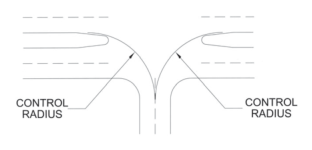
e.Relocation of utilities. The developer shall be responsible for the relocation of public or private utilities and drainage structures as may be occasioned by the required project access improvements.
(9)Left turning control radii. The path of the inside wheels during left turns is important for the design of median openings and intersections with dual left turn lanes. The following radii shall be used for the design of entrance improvements.
Figure 11.4-2: Left Turning Control Radius
Rebuilt from the published figure · verify at source

Table 11.4-8 Left Turning Control Radius Driveway Use Residential Commercial Control Radius (Ft) 40 50
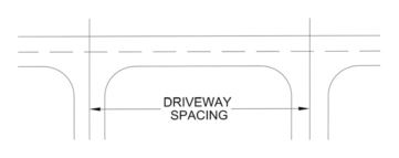
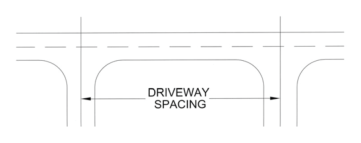
(10)Corner sight distance. All driveways shall provide adequate corner sight distance in accordance with the standards established for an intersection as set forth in subsection 113-128(6).
(11)Separation and spacing. All driveways except those serving residential units on individual lots shall be recommended to meet the following criteria:
a.Spacing requirements, associated with the construction of new driveways, are provided in the following table 11.4-9. Driveways should be separated from any other facility, which accesses a city roadway, whether it is another driveway or a public street. Minimum spacing requirements also apply to driveways on the opposite side of undivided roadways.
Figure 11.4-4: Spacing Criteria for One-Way Driveways
Rebuilt from the published figure · verify at source
Figure 11.4-3: Spacing Criteria for Driveways
Rebuilt from the published figure · verify at source

Table 11.4-9 Driveway Spacing Criteria Posted Speed (MPH) Minimum Driveway Spacing (Ft)(1)

25 200 30 250 35 300 40 300 45 300 50 300 55 350 Notes: (1) Requirements for the length of right and left turn lanes, as shown in table 11.4-4 and table 11.4-6, may increase the minimum allowable spacing shown in table 11.4-9.
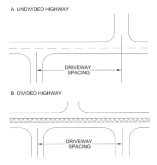
Figure 11.4-5: Spacing of Offset Driveways
Rebuilt from the published figure · verify at source

If the city roadway involved is a divided facility and the driveways do not align with a median crossover, the driveway spacing would only apply to the adjacent driveway located on the same side of the roadway as shown above in figure 11.4-5.

Meeting the spacing criteria is not, in itself an indication that driveways will be allowed.

e.Maximum number of driveways serving a single project: one for each full 200 feet of property frontage This is not meant to be a spacing standard but only an expression of the maximum number of driveways that are permitted serving a single project.
(12)Raised islands. Raised islands associated with entrance improvements shall be designed in accordance with the standards provided in subsection 113-128(5).
(13)Right-in, right-out driveways.
a.Raised islands are also typically used to channelize the movements at a driveway where only right turns are allowed. The raised island is an effective means of preventing left turns. All right-in, right-out islands must have a radius that is 70 feet, or a compound curve that approximates 70 feet.
b.Right-in, right-out driveways are not intended for truck traffic, so the exit and entrance lanes must be 12 feet in width as measured from face of curb to face of curb. The island must be constructed from mountable curb (three inches vertical, 45 degree face, three inches flat) to accommodate emergency vehicles. The edge of the island should be offset 18 inches to 24 inches from the edge of the travel lane.
(14)Pavement design.
a.All construction, within the right of way, of surfaces intended for travel by motorized vehicles shall be paved. The pavement specification of auxiliary lanes on city roadways shall be the GDOT Standard Specifications for Construction of Roads and Bridges, or as designated in city standards, whichever is more restrictive.
b.New developments are required to widen the road along their frontage to a uniform lane width of 12 feet. If the widened area is two feet or less in width, a concrete sub-base should be provided per the current standards. The developer must then either pave the entire width of the road, or mill to the centerline and pave to match the existing road. Transitions shall be milled a minimum of 25 feet. Any deviation from this standard requires a waiver from the public works director.
c.When pavement construction requires the installation of an overlay, the overlay shall comply with subsection 113-129(3) of these regulations.
(15)Pedestrian considerations. When driveways are constructed in areas where pedestrian activity is not prohibited, the design should adequately provide for pedestrian movement and interaction with vehicular traffic. Pedestrian features that should be considered include sidewalks, multi-use trails, crosswalks, traffic control features, curb ramps and detectable warning strips where required. The Americans with Disabilities Act Accessibility Guidelines must be utilized where pedestrian traffic is expected.
(16)Traffic impact studies. Any proposed site plan or subdivision plan which would be expected to generate over 100 total trips during the peak hour of the traffic generator or the peak hour on the adjacent streets, or over 750 trips in an average day shall submit a traffic impact study in accordance with the city standards. In addition, the city may find that proposed or existing site conditions may warrant the submission of a traffic impact study even when the above thresholds are not exceeded. Those conditions may include, but not be limited to the following:
a.High traffic volumes on surrounding roads that my affect movement to and from the proposed development.
b.Lack of existing left turn lanes on the adjacent roadway at the proposed access drive.
c.Inadequate sight distance at access points.
d.The proximity of the proposed access points to other existing drives or intersections.
e.A development that includes a drive-through operation
(Ord. No. 2009-06-18, (11.4), 6-29-2009)
Table 11.4-7 Left Turn Storage
Peak Equivalent Hour Neighborhood Left Size (#of Lots) Turn VolumeSpeed Limit of Road
35 40 45 55 MPH MPH MPH MPH
Queue Queue Queue Queue Feet Feet Feet Feet
Table 11.4-8 Left Turning Control Radius
Peak Equivalent Hour Neighborhood Left Size (#of Lots) Turn VolumeSpeed Limit of Road
35 40 45 55 MPH MPH MPH MPH
Queue Queue Queue Queue Feet Feet Feet Feet
Reading grid · rebuilt for display · verify at source
§ 113-125

General layout requirements.

Sec. 113-125. General layout requirements.

(1)Conformance. The arrangement, character, extent, width, grade, and location of all streets shall conform at a minimum to the comprehensive plan and these regulations.
(2)Local streets and collectors. Local streets shall be laid out so that their use by through traffic will be discouraged. Collectors shall be provided to channel through traffic movements within a development, where appropriate to the design and a major thoroughfare is not proposed by the comprehensive plan. Collectors also may be provided as central routes within large residential subdivisions, where appropriate to the design, based on project traffic demands exceeding 4,000 trips per day (ADT). However, this is not intended to eliminate interparcel access or desirable connectivity as required in section 113-123(2).
(3)Cul-de-sac and dead end streets or alleys.
a.Maximum length without an approved turnaround. Dead end streets or alleys more than 150 feet in length, as measured from the centerline of the intersecting street to the end of the improved access road, shall provide a cul-de-sac turnaround. Alternative turnarounds may be provided as approved by the fire marshal and the public works director.
b.Minimum street length. The minimum street length for a cul-de-sac street shall be 50 feet.
c.Maximum design length. Cul-de-sac or dead end streets may be no more than 600 feet in length as measured from the nearest intersection. Additional length necessitated by topography or property configuration may be approved by the public works director.
d.Measurement of cul-de-sac length. The length of a cul-de-sac street shall be measured along the centerline from the point of tangency of the entrance radius to the point of curvature for the cul-de-sac radius return.
e.Eyebrow cul-de-sacs. Eyebrow cul-de-sac (half cul-de-sacs) will not be permitted at "right-angled" intersections. Eyebrow cul-de-sacs shall only be allowed on a tangent or straight road section or on curves meeting the minimum standards of subsection 113-127(3).
f.Conformance to standard drawings. Cul-de-sacs shall conform to the layout and dimensional requirements as shown in the standard drawings.
g.Cul-de-sacs with landscape islands. Non-standard cul-de-sacs will be evaluated individually and may be constructed with a landscaped island (subject to approval by the fire marshal and the public works director) to be maintained by the home-owners association in perpetuity.
h.Minimum cul-de-sac radius. Minimum cul-de-sac radii shall be 50 feet.
(4)Other dead end streets.
a.A dead end street shall be provided to the boundary of a subdivision where necessary to provide access to a land-locked abutting property, for planned continuity of future circulation, for improved access for public safety vehicles, or for the extension of public water or other utilities to neighboring lands. Such dead end streets shall be designed so as to allow their reasonable extension, and shall be located so as to be reasonably incorporated into a street design for the neighboring property. The stub street requirement may be waived by the public works director, provided the fire marshal concurs.
b.Dead end streets on abutting property shall be extended into a proposed subdivision and incorporated into the street design of the development. This requirement may be modified by the director in cases of serious topographical hardship or dissimilar zoning which would create unacceptable land use conflicts between the two developments. This modification may be conditioned on the provision of easements necessary for the extension of public utilities, the provision of cul-de-sac or other permanent turnaround on the dead end street, or the removal of the dead end street back to its nearest intersection.
c.Where a dead end street (other than a cul-de-sac) serves more than three lots, the developer shall be required to provide a temporary vehicular turnaround within the right-of-way. This requirement may be waived if extension of the dead end street is approved and under construction prior to its inclusion in a final plat.
d.Where a street dead ends at the property boundary and the street exceeds the maximum cul-de-sac length a permanent cul-de-sac shall be required. In this situation, right-of-way to the property boundary shall be required, but the pavement shall not be extended to the property boundary beyond the edge of the paved cul-de-sac turnaround.
(5)Service roads.
a.Where a development borders on or contains a railroad right-of-way, or limited access highway right-of-way or major thoroughfare, a public street may be required to be constructed and dedicated within the development approximately parallel to and on each side of such right-of-way.
b.All driveways along designated thoroughfares with existing or planned service roads shall provide access to such service roads. To gain temporary direct access to the thoroughfare, the developer shall construct the section of the service road adjacent to the development. The service road section shall be located where planned. Any right-of-way not previously dedicated shall be dedicated prior to consideration of a temporary driveway approval providing direct access to the thoroughfare.
(6)Half-streets. Half-streets (new boundary streets having one-half of the minimum required right-of-way or pavement width) shall not be allowed nor access to same be permitted should it exist.
(7)Reserve strips. Land in private ownership adjacent to public rights-of-way which could control or are intended to control access to streets, alleys, or public lands shall not be permitted unless their control is given to the city under ownership, dedication, or easement conditions approved by the city attorney or acceptable to the public works director. No development shall be designed so as to deny access to abutting properties.
(8)Alleys. Alleys shall not be provided except where the developer produces evidence satisfactory to the public works director of the need for same. In the event the public works director approves a design which proposes alleys, the alley shall be constructed as though it were a local street (except where a specific standard for alley exists) pursuant to the standards contained in these regulations, including fire apparatus turn around as required in subsection (3) of this section.

Refer to subsection 113-126(1) for additional information on required pavement widths for alleys.

(9)Street jogs. Streets shall be aligned as per driveways as shown on table 11.4-9.
(10)Traffic calming. Where residential streets are longer than 600 feet, traffic calming devices may be incorporated as required by the public works director. The design of all measures shall comply with the applicable standards for the construction of such measures.
(11)Bike lanes. When required, the developer shall dedicate sufficient right-of-way to the city, or applicable entity, and install the necessary pavement and other improvements for the construction of bicycle lanes in locations as may be required by the director. Bicycle lanes shall be a minimum of four feet in width as measured from the edge of pavement, not including curb and gutter, and constructed in accordance with the AASHTO Guide for the Development of Bicycle Facilities, latest edition, and the Manual of Uniform Traffic Control Devices for Streets and Highways, latest edition.
(12)Bus shelters. When required, the developer shall provide bus shelters within or adjacent to the right-of-way which are in compliance with the design standards of the local transit authority and as approved by the city. The public works director may require the construction of turnout areas, widened shoulders or other facilities necessary to accommodate the loading and unloading of passengers. (Ord. No. 2009-06-18, (11.5), 6-29-2009)
§ 113-126

Minimum right-of-way and street improvements.

Sec. 113-126. Minimum right-of-way and street improvements.

(1)Right-of-way and pavement widths.
a.Minimum right-of-ways shall be as shown on the following table or per the city right-of-way plan, unless otherwise approved by the public works director.

Table 11.6-1 Minimum Right-of-Way Per Street Classification Street Classification Minimum Right-ofWay (Ft)

Principal arterial 150 Minor arterial 80 Collector 60 Nonresidential local 60 Local (Residential subdivision)

50 Alley 20 Cul-de-sac 60 As Measured from Centerline (Ft)

75 40 30 30 10 N/A

b.Additional street right-of-way width may be required to be dedicated at intersections or other locations fronting the property where turning lanes, storage lanes, medians, realignments, sidewalks, multi-use trails, utilities or other necessary improvements are required and minimum right-of-way standards would be inadequate to accommodate the improvements.
c.A minimum of ten-foot travel lanes are required on all streets, except for alleys where the principal structure may also be served by a higher classification street. Roadway widths and lane assignments are typically based upon the functional classification of said roadway, but in no case shall those widths be less than shown in the following table, unless otherwise approved by the public works director:

Table 11.6-2 Minimum Pavement Widths Street Classification Principal and minor arterial Collector Local (nonresidential) Local (residential) Nonresidential local Alley Notes:

Minimum Lane Width (Ft)(1), (2) 12 12 12 10 12 16 (3)

1.Lane widths exclude curb and gutter.
2.Additional pavement width may be required in areas where bicycle lanes are to be installed.
3.Expressed as total paved width of the alley, excluding curb and gutter, if required.
d.Median divided roadways may be required with left-turn bays and median breaks in lieu of center two-way left turn lanes.
e.Existing streets shall be continued at the same or greater width, but in no case shall it be less than the required width provided herein. Where street widths change an appropriate transition shall be provided as approved by the public works director.
(2)Street rights-of-way.
a.Dedication of street right-of-way. Right-of-way for all public streets, existing and proposed shall be dedicated in accordance with the street classifications as shown on the functional classification map of the comprehensive plan and in accordance with these regulations. Right-of-way dedications shall be made prior to the approval of a final plat or, where a final plat is not involved, prior to the issuance of a land disturbance permit, unless otherwise approved by the public works director.
b.Right-of-way for projects adjacent to comprehensive plan projects. If a new street or thoroughfare is proposed by the comprehensive plan or the State of Georgia to adjoin or traverse the property, permits shall not be issued until the department has submitted the project to the mayor and city council for review in order to seek a determination if the city should acquire the right-of-way or if a study of alternate routes should be undertaken. The review period by the city shall not exceed 90 days from the date of permit application. If, after the 90-day review, the mayor and city council is unable to reach a decision, there shall not be any further delay of a requested permit for this situation.
c.Right-of-way for projects adjacent to funded roadway projects. If a new street or thoroughfare is funded by the city or the State of Georgia to adjoin or traverse the property, the proposed road right-of-way shall be incorporated into the development plans of the property in accordance with these regulations. The right-of-way requirements contained in these regulations shall govern except where there exists clearly defined plans of GDOT or the city, which require additional right-of-way. In that case, the greater right-of-way requirements shall govern.
d.Right-of-way for projects adjacent to designed roadway projects. Any development with property fronting on an existing city road for which there exists clearly defined plans by the GDOT or the city, may be required to provide road improvements associated with the defined plans or, in lieu of the design and construction, at the discretion of the director, the developer may be required escrow the dollar equivalency of required improvements (including curbing, utility relocation, and drainage structures, etc., as estimated by the developer and verified by the public works department. These funds shall be deposited in the appropriate road construction account prior to the approval of development improvements or within 30 days of city award of a construction contract, whichever occurs first.
e.Dedication of minimum required right-of-way for abutting streets. On any existing street that abuts a property and does not meet the minimum right-of-way requirements as established in these regulations, one-half of the required width of right-of-way shall be dedicated at no cost to the city as measured from the centerline of the roadway prior to the issuance of a land disturbance permit for that property.
f.Location of the right-of-way. Except where it can be shown to be in the best interest of the safety, health and welfare of the general public or specifically approved by the public works department the location of the right-of-way shall be located as follows:
1.The right-of-way shall be parallel to the back of curb and be mitered at intersections to provide adequate area for utilities, sidewalk, multi-use trails, sight distance and maintenance of the right-of-way.
2.Right-of-way shall be located a minimum of 11 feet from the back-of-curb or one-foot from the back of sidewalk/multi-use trail, whichever is greater, to prevent interference or encroachment by fencing, walls, hedges and other planting or structures that may be placed on the adjacent property line at a later date.

[g.] Right-of-way setback adjacent to residentially zoned property. The right-of-way for new public streets or the easement/common area for new private streets must be located a minimum of 50 feet from any peripheral property line adjoining residentially zoned property unless inter-parcel access is required. This setback shall comply with the provisions of subsection 113-125(7) for reserve strips.

[h.] Minimum right-of-way miters. Miters shall comply with the following minimum standards, the miter distances shall be measured along the right-of-way from the point of intersection of the two rights-of-way if they were extended:

1.Twenty-foot miters (minimum) shall be provided at the right-of-way intersection of any major thoroughfare.
2.Ten-foot miters (minimum) shall be provided at the right-of-way intersection of any local roads.
(3)Reserved.
(4)Improvements along state highways. For any development which abuts a state highway or other right-of-way controlled by the State of Georgia, improvements to the roadway and the location and design of any street or driveway providing access from the state highway shall comply with the standards and requirements of GDOT or the city public works department, with the more restrictive requirements controlling. The proposed access or improvements shall be required to have been approved by GDOT and incorporated into the construction drawings for the project prior to issuance of a land disturbance permit by the department. (Ord. No. 2009-06-18, (11.6), 6-29-2009)
§ 113-127

Roadway design.

Sec. 113-127. Roadway design.

(1)Street grades and design speeds.
a.Minimum grade. Minimum grade for all local streets shall be 1.5 percent. Minimum grades for all collector and arterial streets shall conform to GDOT practice.

Minimum grades of less than 1.5 percent on a local street may be approved by the department, based on adequate engineering designs, where at least 1.5 percent cannot reasonably be achieved due to topographical limitations imposed by the land. In such cases, a record drawing and such computations as necessary shall be provided after construction to establish that the street will drain in accordance with these regulations. Street sections where unacceptable pooling, excessive spread at catch basins, or other hazardous conditions occur shall be reconstructed or otherwise improved to eliminate such conditions.

b.Maximum grade and design speed. Minimum vehicle design speeds and maximum grades allowable in the city by street classification shall be as shown in the following table.

Table 11.7-1 Minimum Design Speeds and Maximum Grades Street Classification Principal arterial Minor arterial Collector Nonresidential local Residential local Maximum Grade (1)

6% 10% 12% 12% 14% (3)

Minimum Design Speed (MPH)

(2)40 30 30 25 Notes:
1.Maximum grade in excess of those listed above may be approved by the public works director in order to address topographical, safety, hydrological, and environmental concerns.
2.Minimum design speed shall be determined by the public works director.
3.Grades between 12 percent and 14 percent shall be limited to a maximum length of 150 feet. The distance shall be measured as the tangent length between points of curvature.
c.Maximum grade for cul-de-sac. Maximum grade on any cul-de-sac turnaround shall be six percent.
d.Roadway cross slope. The standard roadway cross slope is two percent down from crown to gutter line or edge of pavement. In areas where pavement width is being added to an existing street, the additional pavement shall match the cross slope of the existing roadway.
(2)Vertical street alignment.
a.Requirements for vertical curves. All changes in street profile grades having algebraic difference greater than one percent shall be connected by a parabolic curve having a minimum length (L) equal to the product of the algebraic difference between the grades in percent (A) and the design constant (K) assigned to the street according to its category (i.e., L=KA).
b.Required K values.

Table 11.7-2 Constant (K) Values for Vertical Curves Street Crest Curves SAG Curves Classification Principal arterial 151 136 Minor arterial 44 64 Collector and nonresiden-19 37 tial local Local residential 12 26

c.Minimum vertical curve length. The minimum length of vertical curve required for safe stopping sight distance shall be calculated using AASHTO "Policy on Geometric Design of Highways and Streets", latest edition.
(3)Horizontal street alignment.
a.Minimum horizontal curves and superelevation. All new streets shall adhere to the following standards governing horizontal curvature and super elevation:

Table 11.7-3 Horizontal Curves Street Classification Minimum Radius (Ft)

Maximum Superelevation Principal arterial Minor arterial Collector Nonresidential local Local Notes:

1,333 560 300 150 120 0.06 0.04 0.04 (1) Normal Crown Normal Crown

1.No super elevation will be allowed on collectors internal to residential subdivisions.
b.Calculation of super-elevation. Super-elevation for horizontal curves shall be calculated utilizing the following formula:
R= v2/(15 (e + f) ) where:

R = minimum radius curve v = vehicle design speed (MPH) e = rate of super-elevation (decimal of a foot rise per foot roadway) f = side friction factor Vehicle design 30 40 50 60 speed (v)

Side friction factor (f)

0.16 0.15 0.14 0.12

c.Super-elevation when widening existing streets. Widening section along existing streets shall be designed reflecting existing curvature and super elevation, if any, unless the existing street has been included in a specific design by the city or GDOT which calls for different standards, in which case the project will be coordinated with the overall design.
d.Super elevation runoff. Roadway edge curves shall be provided for tangent run out (bringing edge from a normal crown to centerline elevation) and super elevation runoff (from the end of tangent run out to the point of design super elevation) in accordance with design standards of GDOT or other professional engineering standards.
e.Tangents and compound curves. Between reverse horizontal curves there shall be not less than the minimum centerline tangents shown in table 11.7-4 unless otherwise specified by GDOT. Compound radii curves are prohibited. For compound circular curves that cannot be avoided, the ratio of the flatter radius to the sharper radius shall not exceed 1.5 to one.

Table 11.7-4 Tangents Street Classification Principal arterial Minor arterials Collector Nonresidential local Local Minimum Tangent Length (Ft) 150 100 75 75 50

(4)Horizontal and vertical clearances.
a.Horizontal clearances.
1.Shoulder width. A shoulder of no less than 11 feet from the back of curb or edge of pavement, appropriately graded and having gentle slopes of not more than 0.5 inch per foot and rounded cross-sectional design shall be maintained along all streets. Beyond the shoulder but within the right-of-way, slopes shall not exceed one foot of rise for each two feet of horizontal distance on a cut slope, and one foot of fall for each three feet of horizontal distance on a fill slope.
2.Clear zone. Experience has shown that motorists occasionally run off the roadway and providing a traversable recovery area can lesson serious injury. AASHTO publishes a roadside design guide that should be used as a reference when designing driveways.

The following table provides the clear zone distances as contained in the roadside design guide. Driveways must be designed so that all areas within the roadway right-of-way have clear zones as defined in the following table.

Design Speed (MPH) 40 or Less 45-50 55 60 Table 11.7-5 Clear Zone Distance (Distances are Measured in Feet) (From AASHTO 2002 Roadside Design Guide )

Design ADT Fill Slopes 6:1 or Flatter 5:1 to 4:1 3:1 Under 750 750-1500 1500-6000 Over 6000 Under 750 750-1500 1500-6000 Over 6000 Under 750 750-1500 1500-6000 Over 6000 Under 750 750-1500 7-10 10-12 12-14 14-16 10-12 12-14 16-18 18-20 12-14 16-18 20-22 22-24 16-18 20-24 7-10 ** 12-14 ** 14-16 ** 16-18 ** 12-14 ** 16-20 ** 20-26 ** 24-28 ** 14-18 ** 20-24 ** 24-30 ** 26-32* ** 20-24 ** 26-32* ** 3:1 7-10 10-12 12-14 14-16 8-10 10-12 12-14 14-16 8-10 10-12 14-16 16-18 10-12 12-14 Cut Slopes 5:1 to 4:1 7-10 10-12 12-14 14-16 8-10 12-14 14-16 18-20 10-12 14-16 16-18 20-22 12-14 16-18 6:1 or Flatter 7-10 10-12 12-14 14-16 10-12 14-16 16-18 20-22 10-12 16-18 20-22 22-24 14-16 20-22 65-70 1500-6000 Over 6000 Under 750 750-1500 1500-6000 Over 6000 26-30 32-40* ** 14-18 18-22 24-26 30-32* 36-44* ** 20-22 24-26 26-28 18-20 20-26 ** 10-12 14-16 14-16 24-26 28-36* ** 12-16 18-20 20-22 28-32* 34-42* ** 16-20 22-24 26-28 30-34* 38-46* ** 22-24 26-30 28-30 Notes:

*Clear zones may be limited to 30 feet ** Fixed objects should not be present in the vicinity of the toe of these slopes. The width of the recovery zones should consider a number of factors including right of way availability, economic factors, safety needs, and accident history.

All areas located within the clear zones should remain clear of obstructions such as bridge abutments, poles, trees, etc. If obstructions are unavoidable, the design should include appropriate protection such as break-away design, guardrail installation, safety end treatments on culverts, etc. The roadway design guide includes a table for horizontal curve adjustments, where the clear zone correction factor is applied to the outside of curves only. Curves flatter than a 2,860 foot radius do not require an adjusted clear zone.

3.Increased clear zone in certain locations. At selected locations, such as the outside of a sharp curve, a wider clear zone with greater horizontal clearances to any roadside obstruction may be required.
4.Removal of obstructions. The department of public works, in accordance with O.C.G.A. § 32-6-51 and these development regulations, is authorized to remove or direct the removal of any sign, signal, device, vegetation, or other structure erected, placed, or maintained on the right-of-way of a public road which because of its nature, construction, or operation, constitutes a danger to, or interferes with the vision of, drivers of motor vehicles.
b.Vertical clearances. Vertical clearance for all overhead obstructions shall be at least 16 feet over the entire roadway width.

Additional clearance may be required for obstructions over railroads, state or federal roadways or other transportation routes. (Ord. No. 2009-06-18, (11.7), 6-29-2009)

§ 113-128

Street intersections.

Sec. 113-128. Street intersections.

(1)General requirements. Street intersections shall be consistent with the applicable requirements for driveways as determined by the public works director and as set forth in section 113-124.
(2)Intersection approaches; horizontal alignment.
a.New local streets which approach an intersection with a street in a category higher than itself on a horizontal curve having a centerline radius less than 240 feet shall provide a tangent section of roadway at least 30 feet long. Collectors approaching an intersection with a major thoroughfare on a horizontal curve having a centerline radius of less than 550 feet shall also provide the 30-foot tangent section. The tangent length shall be measured along the centerline of the street, from the right-of-way line of the intersecting street, extended, to the point of tangency with the centerline of the curve section.
b.New major thoroughfares shall provide tangent sections at intersections with streets in equal or higher categories as needed to provide adequate stopping distances at their design speeds.
(3)Intersection approaches; Vertical alignment.
a.Approach landings at local streets. For new street intersections with local streets, a leveling of the street at a grade not exceeding three percent shall be provided for a distance of not less than 50 feet as measured from the back of curb of the intersecting street.
b.Approach landings at collectors or arterials. As a street approaches an intersection with a collector or arterial, there shall be a suitable leveling of the street at a grade not exceeding two percent and for a distance not less than the following minimums:

Table 11.8-1 Approach Distances at Major Intersections Approaching Street Minimum Approach Classification Tangent (1) (Ft)

Principal or minor arterial 100 Collector 75 Local (residential and nonresidential)

50 Notes:

1.Distance of the approach is measured from edge of pavement of the intersecting street to the point of curvature in the approaching street.
(4)Intersection radii.
a.Intersection radii for roadways as measured at back of curb and for the right-of-way lines shall be as follows. The minimum roadway radii for the intersection of local and non-residential local streets is 25 feet. For all other roadway classifications the minimum roadway radii is 50 feet. When a local or residential collector intersects a higher classification of roadway, the radii shall be a minimum of 50 feet. Larger radii may be required for streets intersecting at an angle of less than 90° or when vehicle and operating circumstances dictate. As approved by the public works director, the radii can be reduced a maximum of five feet for the following reasons:
1.Separation from street; or
2.Removal of obstruction.
b.Intersecting right-of-way lines shall be joined by a miter which cuts across the right-of-way lines connecting the points where the required radius would have otherwise been tangent. Miters shall be measured as provided in subsection 113-126(2)h.
(5)Islands.
a.Islands in street intersections shall conform to the design requirements of the standard drawings. In no case shall anything in an island in the right-of-way extend more than three feet above the street grade within the right-of-way, except traffic regulatory devices and other infrastructure erected or approved by the city. No island shall be approved which contains less than 100 square feet for median islands or 50 square feet for corner islands.
b.Islands within the right-of-way or access easements shall be constructed with mountable curb sections per GDOT specifications, unless otherwise approved by the public works director.
c.Islands are an important form of intersection channelization that is often needed to prohibit undesirable movements, define the paths of allowed movements, and provide a refuge area for pedestrians. Any location where two outbound lanes are proposed for a driveway at an un-signalized location, the right line must be for right-out only movement, and separated from the other lane by a raised island.
d.Painted lines are an effective means to direct the paths of vehicular movement. However, raised islands are more effective during times when visibility is reduced. When islands are to serve as pedestrian refuge areas, they should be constructed as raised islands. All sign posts to be placed within concrete area must have hole through pavement structure. The hole may be either formed, drilled or sawed.
e.When multiple crosswalks are required to pass through islands, the required size may exceed the 100 square feet mentioned above. The additional area may be required to install wheelchair ramps. As an alternate to ramps, the pedestrian travel way can be "slotted" through the island, remaining on the grade of the roadway.
f.Raised islands should be offset from the edge of the adjacent travel lane on all sides. The amount of offset shall be a minimum of 18 inches as measured from the edge of the travel lane to the face of the curb. When raised islands are adjacent to roadways with posted speed limits of 50 m.p.h. or greater, the island shall be offset from the edge of the roadway by a minimum distance of ten feet.
(6)Intersection sight distance.
a.Intersections shall be designed with adequate corner sight distance. Where necessary, back slopes shall be flattened and horizontal or vertical curves lengthened to provide the minimum required sight distance.
b.The minimum intersection sight distance requirement may be calculated using AASHTO "Policy on Geometric Design of Highways and Streets," chapter 9 (Intersections), latest edition. Intersection sight distance is determined with an assumed height of driver's eye of 3.5 feet and an assumed height of object of 3.5 feet when measuring in the vertical plane. When measuring in the horizontal plane, the intersection sight distance is determined with an assumed driver's eye location from a point four feet offset from the centerline and 15 feet from the edge of closest travel lane to a point along the centerline of the closest oncoming travel lane. When measuring in either plane, the line of sight must remain within the proposed standard dedicated right-of-way:
Table or figure — shown as printedverify at source
Figure 11.8-1: Design Elements for Intersection Sight Distance
Table 11.8-2 Minimum Intersection
Design Speed (MPH)Sight Distance (Ft) (1)
2-Lane 3 and 4 Lanes 5 and 6 Lanes
SDL=SDR SDL SDR SDL SDR

25 280 30 335 35 390 40 445 45 500 50 555 55 610 Notes:

Sight Distance (Ft) (1)

3 and 4 Lanes 5 and 6 Lanes SDL SDR SDL SDR n/a n/a n/a n/a 350 375 400 420 410 440 465 490 470 500 530 560 530 560 595 630 590 625 660 700 650 685 730 770

1.SDL refers to "sight distance to the left" and SDR refers to "sight distance to the right."
2.Minimum intersection sight distance for stopped passenger vehicles turning onto a roadway with no median and grades of three percent or less. Distances shall be adjusted for entering roadways with different design characteristics.
(7)Obstructing visibility at intersections. On any corner lot, within an area formed by the lot lines on the street sides of such lot and a line (miter) joining points on such lot lines located at a distance of 20 feet from the point of their intersection, the following shall apply:
a.There shall be no fence or wall or hedge higher than three feet.
b.There shall be no obstruction to vision, other than a post or column or tree (except standards erected by city) exceeding one foot in greatest cross-sectional dimension, between a height of three feet and a height of 15 feet above the established grade of either of the intersecting streets.
c.The public works director may require additional restrictions based on the horizontal or vertical curvature of the roadway or any unique features of the intersection.
(8)Turning lanes at intersections. Left turning lanes shall be provided on all new internal project streets, classified as a collector or higher, intersecting a major thoroughfare, and may be required in other locations to meet traffic demand and safe operations. Right turning lanes may be required to meet traffic demands or safety concerns. When provided, turning lanes shall meet the criteria for turn lanes in subsection 113-124(8). (Ord. No. 2009-06-18, (11.8), 6-29-2009)
Reading grid · rebuilt for display · verify at source
§ 113-129

Street construction.

Sec. 113-129. Street construction.

(1)Sub-grade preparation for all streets. Street construction shall be done in accordance to GDOT standards or these regulations, with the more restrictive requirements controlling.
a.Preparation. Sub-grade preparation shall be in accordance with GDOT specifications and these regulations.
b.Unsuitable material. If any sections of the sub-grade are composed of topsoil, organic, or other unsuitable or unstable material, such material shall be removed and replaced with suitable material and then thoroughly compacted as specified for fill or stabilized with stone or a geo-textile or geo-grid as approved by the director.
c.Compaction. Fill shall be placed in uniform, horizontal layers not more than eight inches thick (loose measurement). Moisture content shall be adjusted as necessary to compact material to 95 percent maximum laboratory dry density and the top 12 inches to 100 percent maximum laboratory dry density as determined by AASHTO method T-99.
d.Utility installation. After the earthwork has been completed, all storm drainage, water, and sanitary sewer utilities have been installed within the right-of-way as appropriate, and the backfill in all such ditches thoroughly compacted, the sub-grade shall be brought to the lines, grades, and typical roadway section shown on the plans.
e.Compaction testing. Utility trenches cut in the sub-grade shall be backfilled as specified herein. Compaction tests at the rate of one per 150 feet of trench may be required to verify compaction.
f.Proof-roll. The sub-grade must pass roll testing with a fully loaded dump truck prior to placement of the base material. With the approval of the department, a geo-textile or grid may be used to stabilize a sub-grade that does not pass proof rolling.
g.Use of roads as construction roads. When the street is to be used for construction traffic before the paving work is completed, a layer of stone (except crusher run) shall be laid as a traffic surface. This material shall not be used as a part of the base material. It may be worked into the sub-grade, or it shall be removed before the base course is set up for paving.
h.Temporary drainage. Provisions shall be made to drain low points in the road construction when the final paving is delayed. A break in the berm section is required when the curbing has not been constructed. After installation, drainage under the curb to side slopes is required, using minimum four inch diameter pipe sections.
(2)Base preparation for all streets.
a.Crushed stone base.
1.Base preparation shall be in accordance with GDOT specifications and these regulations. The base material must pass roll testing with a fully loaded dump truck prior to placement of the paving material.
2.Base course thickness shall be in accordance with subsection (3) of this section.
3.Lay one course to a maximum depth of eight inches. If the required depth exceeds eight inches construct two or more courses of equal thickness. Moisture content shall be adjusted as necessary to compact material to 100 percent maximum laboratory dry density as determined by AASHTO method T-180.
b.Prime coat.
1.If a delay in paving is reasonably expected by the developer or the city, the base shall be primed with 0.25 gallon of R.C. 70 per square yard the same day it is compacted, and cured for seven days prior to paving.
2.Prime coats may also be required for cement or lime stabilized bases or sub-bases, regardless of pavement thickness.
3.Prime coats shall not be applied to a wet surface, in air temperatures less than 40 degrees F in the shade or if rain is imminent.
c.Soil cement subgrade.
1.If the subgrade material (resident soil) is unsatisfactory to the city then a soil cement mix design with engineer test results acceptable to the city may be used. The design must come from a geo-technical firm with the results certified by a professional engineer registered in the State of Georgia. The tests required for the design are ASTM D558 or AASHTO T134 or ASTM D559 and/or 560 or ASHTO T135 and 136.
2.The minimum base course shall consist of at least six inches of suitable soil (high mica content not suitable) stabilized with ten percent of Portland cement by volume (approximately 42.3 pounds per sq. yd.). Where the grade of the street is five percent or greater, a single surface treatment course must be applied before the binder.
(3)Paving standards for all streets.
a.Asphalt streets.
1.Asphalt paving installation shall be in accordance with GDOT specifications and these regulations. Asphalt paving shall not be installed directly on the sub-grade. A graded aggregate base shall be installed in accordance with these and GDOT specifications for all asphalt paving sections.
2.All pavement sections shall be designed by a qualified, registered professional engineer based on the 20-year projected traffic loads for that section. The minimum acceptable pavement sections shall be defined as follows:

Table 11.9-1 Minimum Construction Standards(1)

Street Classification Principal and minor arterials Collectors Nonresidential local Residential local and alleys Base Binder Topping 9.5 mmType II or 12.5 mm 12" GAB 6" (2)

1½"

12" GAB 6" (2)

1½"

8" GAB 3" 19mm 1½"

8" GAB 1½" 19 mm 1½"

Notes:
1.Unless otherwise specified by the public works department or GDOT.
2.Binder course shall consist of four inches 25 mm Superpave base and two inches of 19 mm Superpave binder.
b.Concrete streets. On residential streets five inches of 3500 psi concrete is to be applied on a stabilized and compacted sub-grade with six inches of compacted GAB, or seven inches of compacted GAB on all other streets. The design and construction of the street shall comply with GDOT standards. Use of concrete streets requires the approval of the public works director.
c.Pavement overlays. Where pavement overlays are required they shall comply with the following standards:
1.Finished surface shall be a maximum height of 1.5 inches above the edge of the existing curb and gutter or shoulder, where curb and gutter has not been provided. Edge grinding shall be required in accordance with this section to meet this standard.
2.When edge grinding has been required it shall be performed for a minimum distance of seven feet along the edges/sides and ten feet at the ends of all overlay sections. Edge grinding shall be performed to a minimum depth of one inch ± 0.25 inch.
3.At the direction of the city inspectors all base failures, rutting, cracking and potholes etc. within the area of the overlay section shall be repaired in accordance with GDOT standards prior to resurfacing.
4.A tack coat shall be applied to all surfaces to be overlaid, in accordance with GDOT standards.
(4)Local residential-rural streets. Where allowed local residential-rural streets do not require curb and gutter. The road base shall be extended one foot beyond the edge of pavement, and the shoulders shall extend eight feet from the edge of pavement to a standard ditch section on each side (see standard drawings). Otherwise, the roadway shall comply with the standards for new residential subdivision streets, above. (Ord. No. 2009-06-18, (11.9), 6-29-2009)
§ 113-130

Curb and gutter.

Sec. 113-130. Curb and gutter.

(1)General requirements.
a.Curb and gutter required. All new streets and access improvements shall be provided with curb and gutter except where approved for a rural road section by the department of public works. All areas approved for use of the rural road section shall provide appropriate roadside drainage facilities designed in accordance with the Georgia Stormwater Management Manual as adopted by the city. All gutters shall drain smoothly with no areas of ponding.
b.Alternative curb and gutter design. Alternative curbing designs such as rolled back or vertical curbing without a gutter may be approved by the public works director when such designs are deemed appropriate for the type of development proposed.
(2)Local and collector road curbing. Local and collector road curbing shall meet the following requirements:
a.Concrete shall be class "A" (as defined by GDOT ) and have a minimum strength of 3,000 PSI at 28 days.
b.Typical minimum section shall be 6" x 24" X 12"(GDOT 24-inch type II).
c.Vertical curbing only, except where specific approval has been granted by the public works director for an alternate curb design.
(3)Arterial curbing. Arterial curbing shall meet the following requirements:
a.Concrete shall be class "A" (as defined by GDOT) and have a minimum strength of 3,000 PSI at 28 days.
b.Typical minimum section shall be 8" X 30" X 14" (GDOT 30-inch type II).
c.Vertical curbing only, except where mountable has been specified and approved by the public works director.
(4)Construction methods.
a.Curb and gutter shall be set true to line and grade, horizontal be field staked, and finished to the section shown on the plans. Along the frontage of a road which the city or GDOT has identified for resurfacing within one year of the new construction, the grade of the new gutter shall be placed one inch above the project access improvement pavement grade in areas where drainage will not be adversely affected.
b.Line and grade shall be set by developer's engineer or surveyor on grade less than two percent and over 12 percent, and within 100 feet in both directions from all low points.
c.One-half inch expansion joints or pre-molded bituminous expansion joint material shall be provided at all structures and radius points and at intervals not to exceed 250 feet in the remainder of the curb and gutter.
d.Inferior workmanship or unprofessional construction methods resulting in unacceptable curb and gutter will be cause for rejection of the finished work.
e.Disturbed areas along all curbing shall be backfilled, stabilized, and grassed.
(Ord. No. 2009-06-18, (11.10), 6-29-2009)
§ 113-131

Sidewalks and multi-use trails.

Sec. 113-131. Sidewalks and multi-use trails.

(1)General requirements.
a.The location where multi-use trails shall be installed in lieu of sidewalks is shown on the future sidewalk and trail network map maintained by the department of public works. The director of public works may require the installation of additional sidewalks/multi-use trails where it may be deemed appropriate to provide connectivity to existing or proposed multi-use trail segments.
b.Sidewalks/multi-use trails and curb ramps shall be constructed along the entire property frontage in all new development or redevelopment and along all abutting or internal streets, existing or new, private or public. Where a sidewalk or multi-use trail is not shown on the future sidewalk and trial network map the director of public works may waive the required installation on the abutting street(s). Whenever a discrepancy occurs between the design and construction standards of this section and any state or federal regulation, then the most restrictive shall apply.
c.The director of public works may require the installation of sidewalks/multi-use trails, where appropriate, to provided pedestrian connectivity to adjacent parcels or projects.
d.Sidewalks/multi-use trails shall be installed within the right-of-way or within an easement specifically designated for sidewalk/multi-use trail use as approved by the city.
(2)Sidewalk/multi-use trail installation and timing. Sidewalks/multi-use trails shall be installed as follows:
a.Residential subdivision projects. Sidewalks/multi-use trails shall be installed on both sides of new internal public or private streets (including "eyebrow" turnarounds) and along the entire frontage of all abutting external streets (abutting side). Sidewalks are required on only one side of internal public or private streets in projects developed at densities of 1.5 units per acre or less or where it is determined by the director of public works that a sidewalk on one side of the street meets the intent of these requirements, i.e. a cul-de-sac street serving less than ten lots. Sidewalks/multi-use trails are required adjacent to cul-de-sac turnarounds in accordance with the standard drawings.
1.Residential subdivision developer responsibility. Developers shall install sidewalks/multi-use trails on abutting external streets as shown on the future sidewalk and trail network map, "passive" recreation area lots, and open space lots, and shall install intersection radius curb ramps at new street intersections, and L-shaped mid-block ramps at cul-de-sac turnarounds, prior to approval of the final plat. Sidewalks/multi-use trails on "active" recreation area lots shall be installed prior to issuance of a certificate of occupancy or shall be installed by the developer prior to release of the subdivision maintenance surety agreement, whichever is earlier. Developers shall also install sidewalks/multi-use trails on any vacant lots remaining between developed lots (i.e. dwellings under construction or completed) prior to release of the subdivision maintenance surety agreement.
2.Homebuilder responsibility.

Homebuilders shall install sidewalks/multi-use trails, and curb ramps not required to be installed by developers, on building lots prior to release of the certificate of occupancy for a home.

b.Nonresidential subdivision projects. Sidewalks/multi-use trails shall be installed on both sides of new internal streets (including cul-de-sac and "eyebrow" turnarounds) and along the entire frontage of all abutting external streets (abutting side) prior to approval of the final plat.
c.Non-subdivision projects.

Sidewalks/multi-use trails shall be installed along the entire frontage of all abutting streets (abutting side) prior to the issuance of a certificate of occupancy or completion.

d.Drainage. Where sidewalk/multi-use is required and no curb and gutter exists the developer shall install all necessary drainage facilities, i.e. curb and gutter or swales. The facilities shall be constructed at the developers' expense to minimize the flow of water on or over the sidewalk/multi-use trail section and to comply with allowable gutter spread requirements. Where drainage swales are used the swale shall be located between the roadway and sidewalk section.
e.Maintenance surety agreement. Maintenance surety agreement provided to the city shall include the cost of sidewalk/multi-use trail construction in an amount acceptable to the city.
f.Escrow alternative.
1.The cost of sidewalk/multi-use trail installation may be set aside in escrow with the department of public works if proposed road improvements by the city or the Georgia Department of Transportation may impact the location of a sidewalk/multi-use trail.
2.Where the director of public works determines the topography of the road frontage is such that a special hardship exists on the property, he may authorize a payment to the city in lieu of the required installation of the sidewalk. Criteria shall be established for all such approved hardships by the director of public works to determine how the amount of payment will be calculated. Such criteria to determine the method of calculating such payment shall be approved by the city council and may be amended by the council thereafter upon recommendation of the director of public works or the city manager.
(3)Sidewalk/multi-use trail design and construction standards. Sidewalks/multi-use trails shall be constructed in accordance with the requirements of this section. The public works director is authorized to grant modifications upon specific application due to topographic or drainage difficulty as well as alternative design proposals.
a.Width.
1.Sidewalks shall be at least five feet wide on new internal subdivision streets. Sidewalks shall be at least five feet wide on abutting external streets.
2.Multi-use trails shall have a minimum width of ten feet.
3.If the street is part of an approved sidewalk, pathway or transportation plan then the width and location of the sidewalk shall conform to the requirements of the approved plan.
b.Shoulder. Sidewalk and multi-use trails shall be provided with a minimum graded shoulder width of two feet. When required to support alternative uses, i.e. equestrian, mountain bikes, etc., a five-foot graded shoulder may be required. The slope of the shoulder shall not exceed ± two percent.
c.Transitions.

Where new sidewalks/multi-use trails tie in to existing sidewalks/multi-use trails of a different width or where the proposed sidewalk/multi-use trail must change width then the transition shall be made in a gradual manner at a rate of 5:1. Where this transition is made to tie in to an existing sidewalk/multi-use trail at a property boundary the full width sidewalk/multi-use trail shall extend along the entire length of the project site.

d.Non compliant sidewalks/multi-use trails.
1.All sidewalks/multi-use trails along a property frontage that do not meet the width standards as established in these regulations shall be brought in to compliance with these regulations.
2.When the public works director has determined that the existing sidewalk/multi-use trail is in satisfactory condition the additional width may be achieved by adding additional width to one side of the sidewalk/multi-use trail as approved. In no case shall this additional width be less than one foot.
3.In all areas where the condition of the sidewalk/multi-use trail is deemed unsatisfactory the existing sidewalk/multi-use trail shall be removed and replaced in conformance with these regulations.
e.Landscape strips.
1.Sidewalks/multi-use trails shall be located at least two feet from the back of curb. Sidewalks/multi-use trails in subdivisions in which street trees are provided shall be located at least five feet from the back of curb (bridges excepted). Where no curb exists, or if road improvements are proposed for installation by the city, sidewalks/multi-use trails, including appropriate drainage facilities, shall be constructed in a location acceptable to the department of public works.
2.In areas where a setback from the curb cannot be provided due to unusual site conditions the department of public works may approve the installation of the sidewalk/multi-use trail at the back of curb. In these areas the sidewalk/multi-use trail width may be increased to allow a minimum of four feet of clearance from any portion of an obstruction that must be located adjacent to the roadway, i.e. mailboxes, etc . . .
f.Meandering sidewalks/multi-use trails. Meandering sidewalks/multi-use trails should be incorporated into the design when appropriate and when approved by the public works director. The design of the meanders shall be done in such a manner that the travel distance is not significantly increased for the general public. The public works director may also require meanders when it is deemed to be in the best interest of the city or where necessary to avoid obstructions in the right-of-way that may otherwise be too costly to relocate.
g.Cross slope. Sidewalks/multi-use trails shall be constructed with a maximum cross slope of two percent. Sidewalks/multi-use trails shall not exceed this cross slope at driveway crossings.
h.Running slope. The running slope of sidewalks/multi-use trails that are located adjacent to the roadway shall not exceed five percent. When the grade of the adjacent roadway is in excess of five percent the running slope of the sidewalk/multi-use trail may follow the general grade established for the adjacent roadway.
i.Material.
1.Sidewalks shall be constructed of concrete at least four inches thick and six inches thick across driveway sections. Concrete shall be class "B" (as defined by GDOT) with a minimum strength of 3,000 PSI at 28 days.
2.Multi-use trails shall be constructed of concrete at least six inches thick. Concrete shall be class "B" (as defined by GDOT) with a minimum strength of 3,000 PSI at 28 days.
3.Alternate materials may be required in special overlay or historic districts.
j.Final stabilization. Disturbed areas resulting from sidewalk/multi-use trail construction shall be backfilled, stabilized, and grassed or landscaped.
k.Georgia DOT controlled roads. Sidewalks/multi-use trails located in the right-of-way of roads under the jurisdiction of the GDOT shall be constructed in accordance with GDOT design and construction standards.
(4)Sidewalk/multi-use trail curb ramp design and construction standards.
a.Intersection radius curb ramps shall be provided at street intersections. Straight ramps may be provided at intersections of curbed driveways and at streets without sidewalks/multi-use trails.
b.All curb ramps shall be provided with detectable warning strips that comply with state and ADA specifications.
(5)Damage repair. Damage to sidewalks/multi-use trails and ramps caused by construction or development activity shall be repaired in accordance with this article and subsection 113-147(10) of these regulations. The repairs shall be made at no cost to the city within ten days or prior to issuance of a certificate of occupancy or completion, whichever is earlier. The public works director may require the developer or utility responsible for the damage to establish alternate routes or temporary crossings of the obstruction when deemed to be in the best interest of the general public. (Ord. No. 2009-06-18, (11.11), 6-29-2009)

Sec. 1113-132. Mailboxes.

(1)General requirements.
a.All mailboxes, whether installed on public or private streets, shall comply with the United States Postal Services standards for the construction of mailboxes.
b.Non-yielding and non-breakaway mailbox structures will not be allowed within the clear zone. The use of concrete filled metal pipe for any mailboxes, or the use of horizontally mounted wooded members to support multiple mailboxes is expressly prohibited.
c.The property owner shall be responsible for the maintenance and repair of the curbside mailbox.
d.Lateral placement of the mailbox shall be no more than six inches from the face of the curb or edge of pavement (if no curb and gutter is present) as defined by USPS installation requirements. In no case shall the face of the mailbox extend out over the face of the curb or edge of pavement (if no curb and gutter is present).
e.Mailboxes shall not be constructed in any location that may block or in any way impair or obstruct visibility.
f.The location and installation of cluster box units shall be approved by the public works director prior to installing the units.
(Ord. No. 2009-06-18, (11.12), 6-29-2009)
§ 113-133

Traffic control devices.

Sec. 113-133. Traffic control devices.

(1)Traffic control devices. Street signs, traffic control signs, and devices such as striping and signalization, shall be provided by the developer at no cost to the city. All devices shall be installed prior to the approval of a final plat, or where no final plat is required, prior to the issuance of a certificate of occupancy.
(2)Signing.
a.All signing and pavement marking must be designed and installed in conformance with the latest edition of the manual on uniform traffic control devices.
b.All sign posts to be placed within concrete area must have six inches wide diameter space through substructure. The traffic control signs must be installed per the most recent edition of the manual on uniform traffic control devices (MUTCD) with relation to the installation height, size, distance from curb, etc. In general, signs should be installed at least seven feet but no more than ten feet from the ground to the bottom of the sign, and at least two feet from the face of curb to the closest edge of the sign, or as required by the MUTCD.
c.The signs shall be new die cut anodized aluminum (at least .080 inches thick) with a corner radius no smaller than one and one-half inches and installed on a single square post with standard hardware. This post should be installed to break-away standards with a slip base. The face of the sign shall be fabricated from type VI (wide angle prismatic) reflective sheeting. No two signs shall be mounted on the same post.
d.Should the applicant wish to use decorative poles, notification shall be made to the department of public works. Decorative poles shall be required to meet the same national safety standards required by the city. Documentation may be required prior to approval of the use of decorative poles to verify compliance with safety standards. The cost of maintenance of the decorative pole shall be the sole responsibility of the applicant and/or homeowners.
e.As part of the land disturbance permit process, the department of public works will identify the number and location of signs. The minimum sign installation shall conform to the standards established below.
f.The applicant will be responsible for maintaining the signs from installation to final inspection. The city reserves the right to replace stop or yield signs if they have been down for more that 12 hours, to replace any regulatory signs if they have been down for more than seven days, and to replace any other signs if they have been down for more than 14 days. This will be done at the cost to the applicant of $250.00 per sign.
g.The sign inspection shall be done by the department of community development prior to acceptance of the final plat or as established by the director of community development. The signs shall be included in the right of way surety agreement at the same time as the pavement at a cost of $100.00 per sign or as established by the director of community development. If the city needs to replace any signs at the time of the final inspection, the value would be forfeited.
h.The following signs shall be installed in all new subdivisions as applicable. Additional signs may be required by the public works director.
1.Stop signs (R1-1). The stop sign shall be installed on the right side of the approach to which it applies. Stop lines, when used to supplement a stop sign, should be located at the point where the road user should stop. Where there is a marked crosswalk at the intersection, the stop sign should be installed a minimum of four feet in advance of the crosswalk line nearest to the approaching traffic.

Stop signs should be installed in a manner that minimizes the numbers of vehicles having to stop. In most cases, the street carrying the lowest volume of traffic should be stopped. A stop sign should not be installed on the major street unless justified by a traffic engineering study as recommended by the MUTCD. If two streets with relatively equal volumes and/or characteristics intersect, typically the direction that conflicts the most with established pedestrian crossing activity or school walking routes or the direction that has the longest distance of uninterrupted flow approaching the intersection should be stopped.

No all-way stops may be installed in a new subdivision without the permission of the public works director.

2.Yield sign (R1-2). Yield signs shall be installed when there are right turns at an intersection that are channelized apart from the through and/or left turn movements with a striped or raised island. In addition, yield signs should be installed on each approach of a roundabout.
3.Speed limit sign (R2-1). Speed limit signs shall indicate a 25 mph speed limit for streets internal to residential subdivisions, unless it is a non-residential local or collector road for the development, and then it should be no higher than 35 mph. For neighborhood settings, only one speed limit sign shall be installed at each project entrance or at the points of change from one speed limit to another. This sign should be installed no less than 100 feet from the entrance of the subdivision, but no greater than 500 feet from the entrance.
4.Street name sign (D3-1). Ground-mounted street name signs shall be installed at every intersection and shall conform to MUTCD, latest edition. Instead of ground mounted signs, however, overhead street name signs shall be installed where a subdivision street intersects at any traffic signal. Street name signs for public roads shall be green with a one-quarter-inch white border and street name signs for private roads shall be blue with a one-quarter-inch white border. The letter height must be six inches. The letters should be in FHWA series "D" font or lower or as approved by the department of public works. The street name sign shall be a combination of lower-case letters with initial uppercase letters. If the street has no outlet or is a dead end, an auxiliary "No Outlet" or "Dead End" sign shall be installed at the top of the sign post oriented to the proper street.

The street name sign should be constructed on nine inch flat blades and not extruded blades. they will be mounted "flag style" using Tapco Jumbo brackets or equivalent. The street name sign shall be posted on the same post as the stop sign.

5.Roundabout sign. Roundabouts must be signed and marked per GDOT standards. This includes yield signs for every approach, as well as an advance roundabout sign as established by the public works department. The pavement marking shall include yield lines and channelization islands for each approach.
6.Stop ahead sign (W3-1) and yield ahead sign (W3-2). The stop ahead and yield ahead signs shall be installed on an approach to a primary traffic control device that is not visible for at least 250 feet. Please refer to section tables 2C.29 in the MUTCD for additional information.
7.Playground sign (W15-1). Playground signs shall be installed on any vehicular approach to an amenities area.
(3)Sign information and sizes. All signs shall be of the sizes as designated in the following table. This table also included the appropriate reference sections of the MUTCD which explain the proper use and installation of each of the signs previously designated.

Table 11.13-1 Sign Information and Sizes Sign Stop (R1-1)

Yield (R1-2)

Speed limit (R2-1) Roundabout and simple alignment warning signs Stop ahead (W3-1a) and yield ahead (W32a) Playground ahead (W15-1) Street name (D3-1)

MUTCD Sections (2003 Ed.)

2B.04 to 2B.07 2B.08 to 2B.10 2B.13; 2B.18 Review section 2C 2C.29 2C.42 2D.38 Size 30" x 30" 36" x 36" x 36" 24" x 30" 30" x 30"

36" x 36"

30" x 30" Varies

(4)Conformance with MUTCD. All traffic signals and signs shall conform to the manual on uniform traffic control devices (no decorative traffic control devices will be allowed without approval of the public works director).
(5)Striping requirements. Any street with a speed limit of 35 m.p.h. or greater that is impacted by the construction of a development shall be restriped. A stop bar and 50 feet of double yellow centerline will be required to supplement every stop sign impacted by the development. Striping shall be accomplished in accordance with GDOT standards and the manual on uniform traffic control devices.

Pavement markings are required to separate lanes of travel and should be used along all edges of pavement. The following guidelines are provided for designing and installing pavement markings for driveways:

a.All pavement markings installed within the public right-of-way on asphalt surfaces shall be thermoplastic material;
b.Lane lines are generally five inches (white); lane lines are not required where curb and gutter has been provided and the edge of the gutter pan six inches or less from the traveled way. Lanes lines shall be provided along all road sections where the distance from the traveled way to the edge of the gutter pan is greater than six inches;
c.Stop lines should be 24 inches (white);
d.Center lines should be five inches double yellow;
e.Deceleration and left turn lanes should have turn arrows (type 2) spaced every 100 feet and "only" legends between every pair of type 2 arrows;
f.Crosswalks should use the current GDOT standard.
(Ord. No. 2009-06-18, (11.13), 6-29-2009)
§ 113-134

Street lights.

Sec. 113-134. Street lights.

(1)Lighting plan required. A lighting plan, drawn to scale, shall be provided for all city roads where street lights are proposed. At a minimum the lighting plan shall included the following:

Street lights shall be provided by the developer in all new subdivisions which propose the construction of a new street to be dedicated to the city or which propose lot access to existing city streets.

a.Layout design and payment for installation. The applicable power company shall design a lighting layout and submit to the department of public works for approval. Upon approval, the developer shall pay the power company for all costs associated with the installation. Proof of payment shall be provided prior to the approval of the final plat.
b.Fixtures. All fixtures and poles shall meet the requirements of the city and all maintenance shall be the responsibility of the power provider. Fixtures shall be mounted a minimum of 16 feet above the ground and each fixture shall have appropriate arm length to illuminate the street. The city, in addition to other requirements, may require a light to be located at street intersections within the development.

In order to provide a uniform lighting standard the following bulb and fixture types shall be used for providing street and pedestrian lighting within the city:

Two-lane residential roads: 150 Watt high pressure sodium cobra head fixture.

Two-lane collector roads and residential areas with safety and/or visibility issues: 250 watt high pressure sodium cobra head fixture.

Roads with more than two-lanes: 400 watt high pressure sodium flood way fixture.

Pedestrian lighting 175 watt high pressure sodium bulb (Standard Overlay).

Alternate bulbs types may be used if approved by the public works director.

c.Monthly utility costs. The developer shall pay the monthly operation costs of said streetlights until such time as one-half of the units are occupied and the maintenance bond, if required, has expired. The city shall not be responsible for the monthly operation costs for utilities located outside of the public right-of-way or public property.
d.Design criteria. Street lighting design criteria for all residential streets shall conform to the design standards given in section 20 of Illuminated Engineering Society Handbook latest edition.
e.Lighting for developments other than subdivisions. For all developments outside of the right-of-way where site lighting is required, those sites shall conform to the outdoor lighting regulations in the city zoning ordinance.
(2)Street lighting for residential streets.
a.Recommended illumination. The recommended illumination for all residential streets shall be 0.5 horizontal foot-candles or 0.5 lumens per square foot of the roadway pavement when the illuminating source is at its lowest output.
b.Minimum illumination. The lowest foot-candle value at any point on the road pavement shall not be less than one-sixth of the average value, i.e. maximum to minimum ratio of 6:1.
c.Luminary light distribution. The classification of luminary light distribution shall be IES distribution type MS III.
d.Mounting height. The following mounting heights with reference to output of lamp and type of lighting pattern is recommended: Vertical light distribution M = medium Vertical light control S = semi cut off or cut off Lateral light distribution Type III Table 11.14-1 Street Light Mounting Height Lamp Output 150 watt HPS 14500 Lumens 150 watt HPS 14500 Lumens Notes:
IES

Mounting height Type III long 29 feet (1)

Type III 16 feet

1.29-foot mounting height shall only be used in areas with existing overhead wiring.
e.Luminary spacing. The spacing of the luminary shall be governed by factors such as location of utility poles, block lengths, property lines and geometric configurations of the terrain features. Maximum spacing shall be 250 feet.
f.Mounting poles.
1.The mounting poles shall be as per latest regulations and standards of national electric code, the national electric safety code, the American National Standards Institute and NEMA. The basic design criteria required is resistance to 100 mph winds including 1.3 gust factor.
2.All poles shall be black fiberglass or as recommended by the utility company.
3.The pole top shall have a top tenon of three inches o.d. so as to fit a slip fitter.
4.The poles shall have hand hole 4" x 12" opening with an aluminum cover fitted to two SS pentahead screws. The center of handhold opening shall be approximately 24 inches from ground level.
g.Luminaries. Luminaries shall be fitted with built in ballast and photoelectric control and shall conform to meet all the requirements of latest regulations and standards of EEI and NEMA depending upon the lamp load and type and circuit voltage.
h.Wiring and cabling. All wiring and cabling shall conform to the appropriate utility company's specifications.
(Ord. No. 2009-06-18, (11.14), 6-29-2009)

Secs. 113-135—113-140. Reserved.

ARTICLE XII. UTILITIES AND EASEMENTS
§ 113-141

Placement of utilities.

Sec. 113-141. Placement of utilities.

(1)Location of utilities.
a.All authorized public underground utilities shall be located within the right-of-way of a public street or within an easement designated for such use. Within public street right-of-way, placement of the various authorized utilities (power, gas, cable TV, water and sewer) shall conform to the specific locations designated for such use by the city, as illustrated in the standard drawings.
b.When road widening is required, i.e. deceleration lanes, left turn lanes, other road improvements, etc., existing utilities may be required to be relocated, at no cost to the city, to comply with the specific locations designated for such use by the city.
(2)Private utilities within the right-of-way. No other underground utilities, such as private utility vaults, private lawn sprinkler systems, yard lighting, etc., shall be installed within a public right-of-way or easement except by authorization of the department of public works. Such authorization, if issued, shall require the applicant to assume all repair costs of the applicant's facilities should they be damaged during the course of installation, maintenance or repair of any of the public utilities authorized to occupy said right-of-way or easement.
(3)Underground installation of new utilities. Within all new subdivisions utility systems, including water, sewerage, gas, telephone, cable television and electric, along with component parts, structures, appendages and materials, shall be installed underground in a manner approved by the applicable utility provider an in accordance with all city regulations. Above-ground utility systems will not be permitted, except where certain appurtenances and accessories must be installed above-ground for servicing.
(4)Service from existing overhead utilities. Lots that abut existing easements or public rights-of-way where overhead utility supply lines and service connections have previously been installed may be supplied with service from those overhead lines, but the service connections from the overhead lines shall be installed underground. Should a road widening or an extension of service, or other such condition occur as a result of the subdivision and necessitate the replacement or relocation of such utilities, such replacements or relocation shall be underground.
(5)Compliance with other regulations. Any utility work required in conjunction with an authorized land disturbance permit that must be completed within the right-of-way, a city easement or on other city property shall comply with the requirements of any city ordinance or policy regarding the installation of utilities on said property. Any installations performed within the state owned right-of-way or property shall comply with any applicable rules, regulation and guidelines developed for that use by the state.
(6)Utilities located outside of the right-of-way. When, in the course of development, it becomes necessary to construct utilities outside of the right-of-way said development shall conform to these and other applicable regulations. Any permanent or temporary easements required for the construction shall be obtained in accordance with these regulations. The easement area shall be returned to a condition that is equal to or better then the condition that existed prior to construction. (Ord. No. 2009-06-18, (12.1), 6-29-2009)
§ 113-142

Underground utilities.

Sec. 113-142. Underground utilities.

(1)Utilities within the roadway.
a.All water and sanitary sewer utilities and storm drain facilities within the roadway shall be installed and the ditches backfilled and thoroughly compacted before any pavement or base is installed.
b.All utility installations shall comply with applicable local, state and federal requirements for erosion and sediment control.
(2)Installation of utilities after the placement of base material. Once the base has been placed, proof-rolled and approved for paving all further installation of utilities under the roadway shall be bored or other wise comply with section 113-147, street cuts.
(3)Manholes, valve boxes, etc. within the road section. All utility manholes and valve boxes shall be brought flush to the finished grade within the roadway section. (Ord. No. 2009-06-18, (12.2), 6-29-2009)
§ 113-143

Water system and fire hydrants.

Sec. 113-143. Water system and fire hydrants.

(1)Installation required. The developer shall install or have installed a system of water mains connected to a public water supply system in accordance with these requirements and those of the authority having jurisdiction to provide water service within the city, herein referred to as the water authority.
(2)Design policy. All water mains, fire hydrants and appurtenances shall be designed in accordance with the policies, standards, plans and specifications of the city and the water authority.
(3)Installation timing. Water mains and appurtenances shall be installed after installation of the curbs and gutters and before paving, or as approved by the city and the water authority.
(4)Fire hydrant requirements. Fire hydrants shall conform to AWWA C502-85 for dry-barrel fire hydrants and the following requirements:
a.Hydrants shall be traffic type with safety flange that allows the valve to remain closed when the hydrant is broken or damaged above or near grade level.
b.The design of hydrant shall be of the compression type with main valves and "O" ring seal between the operating nut and the bonnet.
c.Hydrant color shall be silver.
d.Hydrant inlet shall be six-inch, mechanical joint with harnessing lugs.
e.Hydrant main valve opening shall be five and one-quarter-inch.
f.Valve seats shall be bronze to bronze.
g.Operating nut shall be solid Pentagon, one and one-half inches measured flat at point (31/32 on side). Operating nut shall turn counter clockwise to open.
h.Hydrant shall have two, two and one-halfinch diameter and one, four and one-halfinch diameter nozzle. Nozzles threads shall be the standard adopted by NBFU. Nozzles shall all have gasketed caps fitted with chain.
i.The following fire hydrants are approved for installation on development projects within the city, other models may be acceptable when dedicated to and approved by the utility provider:

Table 12.3-1 Acceptable Fire Hydrant Models Manufacturer American AVK Mueller Kennedy M&H Clow American-Darling U.S.

Model 2700 and 2780 Centurion and Improved K81-A 129 and 929 Medallion B-62B M-94

j.Materials shall conform to AWWA Standard C-502, latest revision.
(5)Water mains and fire hydrants on private property and subdivisions. In addition to the other requirements of these regulations water mains installed on private property and within subdivisions shall also comply with the following requirements:
a.Water main size.
1.Water mains of at least eight-inch pipe shall be installed; six-inch pipe may be used only where it completes a gridiron and then only up to 600 feet in length between interconnecting mains of approved diameter, unless otherwise approved by the public works director and the fire marshal.
2.No main line smaller than eight inches shall serve more than one fire hydrant and automatic extinguishing system or one fire hydrant on any dead-end main more than 300 feet in length. All water mains shall be sized in accordance with NFPA 24, as adopted by the State of Georgia.
b.Fire hydrant spacing. Fire hydrants shall be spaced not more than 500 feet apart, with additional fire hydrants located as necessary to comply with the requirements of the International Fire Code and Appendices as adopted by the city and approved by the fire marshal.
c.Private fire hydrants. Hydrants that are not maintained by Atlanta-Fulton County Water Department and on a dedicated meter or loop system shall be considered private fire hydrants. These private hydrants shall have general maintenance performed annually in accordance with the currently adopted edition of NFPA 25. These maintenance records shall be maintained on the premises for inspection, or sent directly to the city fire marshal's office for review and filing. All maintenance shall be performed by a qualified company that is familiar with NFPA 25's guidelines. These private hydrants shall also be painted red and a three-foot perimeter shall be maintained free and clear at all times.
d.Clearance around fire hydrants. A minimum of three feet of clearance shall be provided around all fire hydrants.
e.Water main material. Water mains shall be of ductile iron or copper or a type listed for this service by a nationally recognized testing laboratory and approved for use by the water authority.
f.Minimum cover. Water mains shall be installed at least 12 inches below the frost depth. In areas where frost is not a factor the water main shall be installed to a minimum depth of 42 inches below grade. When the water main is installed under a driveway or roadway it shall be installed 48 inches below grade or 48 inches below railroads.
g.Hydrostatic testing. Water mains shall be hydrostatically tested at not less than 200-psi or 50-psi greater than the system working pressure, whichever is greater, and shall maintain that pressure, ± five-psi, for two hours in the presence of a representative of the city. Pressure loss shall be determined by a loss in gauge pressure or visual leakage.
h.Fittings and valves. Hydrants, fittings, valves and fire department connections shall be approved by the fire department. Fire department connections shall be not less than 18 inches or more than 36 inches above the level of the adjoining ground or paving. The thread of such connections shall be uniform with that used by the fire department.
i.Timing of installation. Water mains and fire hydrants shall be installed, under water pressure and ready for fire fighting before any construction with combustible material begins onsite.
j.Dead end mains. In no case shall dead end mains exceed 600 feet in length for main sizes less than ten inches.
(6)Sub meters required. The county water department provides water service to residential multi-unit buildings. These services are billed by the utility on a master meter basis and the landlord or property owner is responsible for paying the utility for all charges contained in such bills. All new multi-family buildings shall be billed by the owner or landlord or by a third party based on sub-unit meters which will be installed at the time of construction.
(7)Commercial car wash water recycling. All new commercial conveyor car washes, permitted and constructed after January 1, 2011, must install operational recycled water systems, regardless of the water source. A minimum of 50% of water utilized will be recycled. This regulation does not apply to self-service car washes or in-bay car washes.
(8)Rain sensor shut off switches on new irrigation systems. Pursuant to O.C.G.A. § 125-6, all new landscape irrigation systems for both residential and nonresidential properties will require rain sensor shut off switches. This regulation does not apply to either landscape irrigation systems installed on golf courses, or any system dependent upon a non-public water source. (Ord. No. 2009-06-18, (12.3), 6-29-2009; Ord. No. 2011-03-06, § 2, 3-28-2011)
§ 113-144

Sanitary sewer disposal.

Sec. 113-144. Sanitary sewer disposal.

(1)Connection to an approved sanitary disposal system. Connection to an approved sanitary sewage disposal system shall be made, which may require the construction of an on-site system or the extension of public sanitary sewerage and associated appurtenances, as required by the county.
(2)Construction standards. All sanitary sewer construction shall conform to the requirements of the county.
(3)Septic tank and drain-field location. Septic tanks and tile drain-field sewerage disposal systems may be required to be located outside of the 100-year floodplain, stream buffers and impervious setbacks as required by the county health and wellness department and city regulations.
(4)Health department requirements. The health department may require a notation that certain lots must meet additional requirements prior to issuance of a building permit, or other wise limit development relative to health department regulations.
a.Such lots may include lots upon which adequate depth to water table must be demonstrated during the appropriate season of the year, adequate percolation tests must be performed, limitations upon the number of bedrooms in a dwelling, etc.,
b.No lot shall be included on a final plat which the health department is not confident will meet all health department regulations at a reasonable cost or within a reasonable period of time, except lots proposed to be served by sanitary sewer in subdivision where "dry" sewer has been installed. Such lots shall be noted: "Approval by Fulton County for connection to sanitary sewer required prior to issuance of a building permit."
(5)Health department approval required. Where applicable, approval of the sanitary sewer system by the county may be required prior to the issuance of a land disturbance permit.
(6)Installation prior to paving. Whenever the installation of a sanitary sewer is required by the service provider, no new street shall be paved without the sanitary sewer being first installed. (Ord. No. 2009-06-18, (12.4), 6-29-2009)
§ 113-145

Separation of water and sanitary sewer lines.

Sec. 113-145. Separation of water and sanitary sewer lines.

There shall be no physical connection between a drinking water supply line and a sewer or appurtenance.

(1)Horizontal separation. Water lines shall be laid at least ten feet horizontally from a sewer or a sewer manhole whenever possible; the distance shall be measured outside edge-to-outside edge. When local conditions prevent a horizontal separation of ten feet, the water line may be laid closer to a sewer or sewer manhole provided that:
a.The bottom (invert) of the water main shall be at least 18 inches above the top (crown) of the sewer. Where this vertical separation cannot be obtained, the sewer shall be constructed of ductile iron pipe and pressure tested in place without leakage prior to backfilling.
(2)Vertical separation. The water line shall be laid in separate trenches or on an undisturbed earth shelf. Where possible the water main shall pass over the sewer main with a vertical separation of at least 18 inches. When local conditions prevent a vertical separation of 18 inches between the bottom of the water main and the top of the sewer the following construction standards shall be used:
a.The sewer shall be constructed of ductile iron pipe and pressure tested in place without leakage prior to backfilling.
b.Adequate structural support for both the water and sewer mains shall be provided to prevent settling and excessive deflection of the joints.
c.That length of sewer main shall be centered at the point of the cross-ing such that the joints shall be equidistant from the point of crossing.
d.No deflection of the joints is permitted within ten feet of the point of crossing.
(Ord. No. 2009-06-18, (12.5), 6-29-2009)
§ 113-146

Easements.

Sec. 113-146. Easements.

The following applies only to easements which have been expressly dedicated to and accepted by to the city.

(1)Drainage easements.
a.Temporary construction easements and permanent easements for drainage shall be dedicated to the city in accordance with these regulations when said easement is deemed to be in the best interest of the public health, safety or welfare. The city shall not be responsible for any easements that are not: (i) expressly dedicated to the city by execution of an easement agreement filed and recorded with the county superior court which (ii) has been accepted by the city through ratification of the city council. All easements shall be stabilized in accordance with the manual for erosion and sediment control in Georgia.
b.Drainage easements are required for any part of the drainage system which is designed to carry stormwater runoff from more than one parcel, existing or proposed.
c.Drainage easements for improved ditches, pipe construction, and detention facilities shall be cleared, opened, and stabilized at the time of development to control surface water run-off. Run-off slope and side slopes shall be specified by the developer's engineer, according to good engineering practice, these regulations and the applicable provisions provided in the stormwater management design manual.
d.Drainage easements for storm drain pipes shall be provided according to the minimum requirements found in the table below. The minimum easement width shall be 20 feet when no other parallel utilities are located therein. For pipe sizes not shown on the table below the easement width shall be based on the pipe diameter (span) plus two feet, plus two times the pipe invert depth. This value shall be rounded up to the nearest five feet. For pipes exceeding 16 feet in depth, a presubmittal conference shall be held with the city to determine what additional requirements may be required.
Table 12.6-1 Easements for Storm Drain Pipes
Pipe Size (In) Invert Depth (Ft)Minimum Easement Width (Ft) 4 5 6 7 8 9 10 11 12 13 14 15 16
1520 20 20 20 20 25 25 30 30 30 35 35 40
1820 20 20 20 20 25 25 30 30 30 35 35 40
2420 20 20 20 20 25 25 30 30 30 35 35 40
3020 20 20 20 25 25 25 30 30 35 35 35 40
3620 20 20 20 25 25 25 30 30 35 35 35 40
42NA 20 20 20 25 25 30 30 30 35 35 40 40
48NA 20 20 20 25 25 30 30 30 35 35 40 40
54NA NA 20 25 25 25 30 30 35 35 35 40 40
60NA NA 20 25 25 25 30 30 35 35 35 40 40
66NA NA NA 25 25 30 30 30 35 35 40 40 40
72NA NA NA 25 25 30 30 30 35 35 40 40 40
Reading grid · rebuilt for display · verify at source
§ 113-147

Street cuts.

Sec. 113-147. Street cuts.

(1)Review of utility plans. All utility construction plans within city right-of-way shall be reviewed and approved by the department before construction begins. A traffic control plan may be required as part of the submittal. Street cuts shall not be allowed unless deemed absolutely necessary due to the presence of rock, the need to tap into an existing line beneath the road surface, or other circumstance which makes boring impossible or infeasible. Where open trenching has been permitted the trench width shall be the minimum width necessary to allow for the installation of the conduit and provide adequate compaction of the backfill material.
(2)Marking of existing utilities. All existing utilities shall be properly marked in accordance with Georgia Utility Facility Protection Act prior to any excavation work.
(3)Maintaining access to private properties. Access to private driveways shall be provided at all times except during working hours when construction operations prohibit provision of such access.
(4)Obstruction of fire hydrants. Unobstructed access must be provided at all times to fire hydrants.
(5)Lane closure. Contact the department of public works at least 24 hours in advance of closure of traffic lanes. The applicant will be responsible for ensuring notice has been received by public works and should utilize verified e-mail notification. All lane closures shall be properly marked and signed with certified flagmen when appropriate.

In trenching across the road, no more than one-half of the traveled way is to be closed to traffic at one time.

(6)Maximum length of open trench. The trench construction shall not be opened for a distance of more than 300 feet at any one time, unless specifically authorized by the public works director.
(7)Damage repair. Whenever a part of a block, square or section of curb, sidewalk, multiuse trail or driveway is broken or damaged by the person making any excavation or opening in or under any street, alley or public place, the entire block, square or section, shall be removed to the score, groove or saw cut line and replaced or reconstructed. Where the line of cut would be less than two feet from an existing expansion or weakened plan joint, the concrete shall be removed to said joint.
(8)Trench construction and backfill.

Definitions and considerations. In trenched construction, bedding is the subgrade soil and its surface, as prepared to support the pipe. Backfill is the material refilling the rest of the level of top of pipe, and of overfill above that level. The latter may include restoration of surface soils or roadway materials. From the highway viewpoint, the essential features for trench and backfill construction are:

a.Entrenched roadbed;
b.Security of the pipe against deformation likely to cause leakage; and
c.Assurance against drainage being blocked by the backfill. Bedding is important for all pipes.

Controls for trenched construction. Trenched construction, bedding, and backfill normally will be adequately controlled by the applicant conforming to the GDOT standard specifications for earth work and culverts as well as standards and details. Specific controls follow:

a.Trenches are to be cut to have vertical faces with a maximum width of two feet or outside diameter of pipe plus 18 inches. They shall be shored where necessary to prevent caving and sloughing.
b.Bedding shall be provided to a depth of 12 inches or half of the diameter of the pipe, whichever is the least. Bedding shall consist of granular soil free of lumps, clods, cobbles and frozen materials, and shall be graded to a firm-but-yeilding surface without abrupt changes in bearing value. Unstable soils and rock ledges shall be sub-excavated from the bedding zone and replaced by imported material. For carriers laid without encasement, the bedding shall be shaped to fit the bottom of the pipe for 60 percent of its width. See the GDOT standard specifications for additional information on backfill material.
c.Backfilling of trenches must be accomplished immediately after the pipeline or other utility is placed therein or as directed by the director. Backfill shall be placed in two stages: first, sidefill to the level of the top of pipe; second, overfill to former surface grade. Sidefill shall consist of granular material laid in six-inch layers, each consolidated by mechanical tamping and controlled addition of moisture, to a density of 95 percent as determined by AASHTO method T-99 or GHD.

Overfill shall be layered and consolidated to match the compaction. The top 12 inches shall be compacted to 100 percent of specified density. Consolidation by saturation or ponding will not be permitted. Use 57 stone material or another GDOT type II material that is approved by the director in wet trenches, these materials shall be compacted like above stated backfill to a satisfactory uniform density as directed by the director.

(9)Pavement cuts. No open cuts in pavement will be permitted except by special permission of the director when there is an emergency and the public health or safety is imperiled, or for making a service tap on a line under the pavement when no other distribution line is available in the area where the service is required. In no event will an open cut be permitted when it is reasonably practical to bore, tunnel, etc., under the surface of the roadway. Whenever the director is requested to authorize an open cut, such request must be made in writing supported by detailed reasons some other method is not practical and giving details relative to the maintenance history and service life of the facility. The department requires (1) that backfill and repaving be performed under its direction at the expense of the applicant and (2) that the applicant remain liable for cost of repair if the backfill subsides or the patched pavement fails. When approval of the director is granted, the following provisions shall be strictly adhered to.
a.The trench edges in paved areas shall be sawed or cut to neat lines by methods satisfactory to the director before starting to break the pavement slab.
b.Materials and methods of shall be adopted to achieve prompt restoration of traffic service.
1.In trenching across the roadway, only one-half of the paved surface is to be opened at one time. The open half shall be completely backfilled before opening the other half.
2.Closure of intersecting streets, road approaches, or other access points for trenching operations will not be permitted. Upon trenching across such facilities, the applicant shall utilize steel running plates, planks or other satisfactory methods for traffic entering or leaving the highway or adjacent properties. Immediately after the facility authorized by the permit has been placed, the intersecting streets, road approaches or other access facilities, shall be restored to at least as good condition as it was prior to the permit operations and in a manner satisfactory to the director. Spot resurfacing, (milling, grinding and/or additional asphalt) may be required.

Once the pavement is cut, it is most difficult to reconstruct to obtain the structural strength and surface quality the road and pavement had prior to cutting. For trenches over four feet wide, the subbase, base and paving shall be replaced in kind using construction procedures in accordance with the current GDOT standard specifications. For trenches up to four feet wide, the subbase, base and paving shall be replaced in kind using construction procedures in accordance with GDOT standard number 1401; except class A GDOT concrete will be used in place of class B or soil cement base and 9.5mm or 12.5mm superpave asphalt will be used or as determined by the director. Utility cuts in Portland cement concrete pavement are discouraged by the department. Pavement cuts, when allowed will require complete or partial slab replacement. The director will determine the extent of slab replacement on a case by case basis if an open cut is allowed. Procedures for slab removal and replacement will use construction procedures in accordance with the current GDOT standard specifications and standard number 1401, also including but not limited to surface tolerance requirements set forth in the current GDOT standard specifications.

Any pavement cuts that are not perpendicular to the roadway's horizontal alignment for asphalt highways shall require the entire width of the roadway to be resurfaced with a minimum of two inches of asphalt that is the same material as the existing surface or as determined by the director in addition to the requirements stated hereinbefore. Any pavement cuts that are not perpendicular to the roadway's horizontal alignment for Portland cement concrete pavement shall be in accordance with the current GDOT standard specifications and standard number 1401. Any manhole or valve shall have a square concrete pad placed around the facility if the facility is located in the traveled way as determined by the director and to the satisfaction of the director.

(10)Sidewalk, multi-use trail and curb cut replacement. All sidewalk, multi-use trail and curb cuts require that the section of sidewalk, multi-use trail and/or curb be replaced from existing joint to existing joint or as determined by the director. All sidewalk, multi-use trail and curb construction shall meet the construction requirements as shown in section 441 of the current GDOT standard specifications or as determined by the director.
(11)Replacement of cuts in unpaved streets.
a.The trench shall be backfilled in accordance with the manner prescribed in this Article for backfilling of trenches. The surface treatment shall match that of the existing road. For gravel roads the trench shall be backfilled up to and within four inches of the street level. The remaining four inches shall be filled up with no. 2 crushed stone, well compacted into place.
b.The base stone shall be kept at street level by the contractor until final acceptance of the project of the city engineer without additional cost to the city.
(12)Public utility extensions. Contact the department of public works for public utility extension information from the existing utility locations to the proposed development. (Ord. No. 2009-06-18, (12.7), 6-29-2009)

Secs. 113-148—113-160. Reserved.

ARTICLE XIII. GRADING AND DRAINAGE
§ 113-161

Erosion control.

Sec. 113-161. Erosion control.

(1)Design standards. The procedures and requirements of the soil erosion and sediment control ordinance, as may be amended from time to time, shall be applicable whenever any land disturbance activity is conducted.
(2)Abandoned projects. Any project, whose permit has lapsed under the terms expressed in article VI, shall immediately have all disturbed areas stabilized. This responsibility shall fall upon the owner, developer, contractor, or any and all other responsible parties involved in the land disturbance activity. (Ord. No. 2009-06-18, (13.1), 6-29-2009)
§ 113-162

Earthwork.

Sec. 113-162. Earthwork.

(1)Clearing and grubbing.
a.The area within the typical grading section shall be cleared of all trees, brush, stumps, logs, grass roots, vegetable matter, poles, stubs, rubbish, refuse dumps, sawdust piles, and all other matter resting on or protruding through the original ground surface or appearing or being placed on the area within the typical grading section before final acceptance of work.
b.This item also includes the removal and proper disposal of all the debris or any obstructions not to be salvaged such as fences and incidental structures within the proposed area to be graded, which might interfere with construction.
c.Clearing and grubbing operations shall be conducted in such a manner as to prevent damage to existing structures, trees to remain and/or protected by ordinance, equipment and any proposed work that has been completed, and to provide for the safety of workmen and other personnel on the job site.
(2)Grading.
a.Grading shall be done in accordance with the lines and grades shown on the approved plan.
b.Grading plans shall show existing and proposed contour lines at an interval of not more than two feet and spot elevations and flow arrows where needed.
c.A grading plan showing building pad locations may be required to be submitted to ensure adequate lot-to-lot drainage.
d.Grading plans shall outline the areas which are required to remain undisturbed, i.e. tree protection areas, undisturbed buffers, stream buffers, wetlands, floodplains etc., and shall indicate protective fencing or staking to be placed around such areas.
e.Shoulder sections shall be provided as required in article XI.
f.If the proposed grading is within the jurisdiction of the Metropolitan River Protection Act, the grading shall be consistent with the river corridor certificate approved for the project.
g.Grading for all roads and improved ditches and channels shall be shown.
h.Unclassified excavation consists of all roadway and drainage excavation, regardless of the nature of the material or the manner in which it is removed. It includes the removal and disposal of unsuitable or unstable material under the roadbed section and back filling with suitable materials.
i.All rock and boulders in the roadbed shall be excavated to a depth of at least 12 inches below the sub-grade and the space back-filled to the correct grade with material suitable as sub-grade.
j.Where materials unsuitable for foundation or roadway purposes occur within the limits of the roadbed and front slopes, the same would be excavated to the bottom of their depth and removed.
(3)Cuts and fills.
a.All depressions below the ground surface containing water shall be drained, unsuitable material removed and filled with suitable material and compacted to the ground surface before the embankment proper is begun. Any area deemed jurisdictional under federal, state or local regulations shall obtain required approvals or permits prior to any land disturbing activities in those areas.
b.The entire area upon which the cut or fill is to be placed shall be plowed, scarified and finely broken up to a depth of at least six inches and all cleavage plains shall be destroyed before the embankment is begun.
c.The fill material shall be deposited and spread in uniform horizontal layers not to exceed six inches thick for the full width of the cross sections and the layers shall be kept level by any approved equipment.
d.Each layer shall be compacted at moisture content proper to permit the compaction specified below. Material containing too much water shall be dried to the correct moisture content. If the material is too dry, water shall be added and uniformly mixed with the soil before it is compacted.
e.The top 12 inches of embankment shall be compacted to at least 100 percent of the maximum laboratory dry density as determined by AASHTO method T-99. Embankment material located between one foot and six feet below the top of the embankment shall be compacted to at least 90 percent of maximum laboratory dry density as determined by AASHTO method T-99. The measurements of depth as described above shall begin at an elevation equal to the bottom of sub-grade treatment where sub-grade treatment material is used.
f.Maximum slope in cut or fill sections shall be 2:1. The slope of cut or fill shall be uniform throughout for each section of cut or fill unless benching is approved by the city.
g.If the 2:1 slope shows evidence of shearing, non-cohesiveness, sliding, or inability to maintain compaction, the slope shall be stabilized at 3:1 or by using such mechanical methods as needed (such as retaining walls or "grow mats" stapled in place) to maintain slope, height, and integrity.
h.When a cut is made in rock that requires blasting, slope may be changed to vertical slope upon the written approval of the city engineer and only under the following conditions:
1.When accompanied by a certification from a registered professional geotechnical engineer stating that the slope material is stable;
2.In no instance shall the slope face be steeper than vertical one-eighth-inch batter is preferred; and
3.The slope face is free from all deleterious material and is not subject to long-term erosion due to excessive runoff on the face of the slope.

[i.] All slopes steeper than 2.5:1 and greater than ten feet in height shall be hydro-seeded and covered with GDOT approved matting and blankets. All slopes must be protected until a permanent vegetative stand is established.

[j.] Slopes over 20 feet in height shall be stabilized in stages by matting and vegetation. Stabilization measures shall be placed in vertical increments not to exceed 20 feet immediately at the completion of each 20 foot lift. A minimum of a four-foot bench every 20 feet is required on 2:1 slopes.

(Ord. No. 2009-06-18, (13.2), 6-29-2009)
§ 113-163

Retaining walls.

Sec. 113-163. Retaining walls.

(1)General requirements.
a.When permanent grades are proposed to be steeper than 2:1 (one vertical foot of rise for every two feet of horizontal displacement) an appropriate retaining structure shall be designed to reinforce or retain the resulting embankment.
b.An engineered design may be substituted for the reinforced concrete design if approved by the director. All structural components of the wall shall meet the minimum building codes for the proposed use, including provisions for safety railings and fences..
c.All wall designs must demonstrate complete dimensions for line and grade. Wall design will consider surface and foundation drainage and select backfill material for the proposed conditions.
(2)Permits required. Where retaining walls are to be installed permits shall be obtained in accordance with article VI of these regulations.
(3)Indemnification/certification. For all retaining walls over four feet in height, the owner of the property containing the proposed wall shall complete an owner's indemnification agreement. For all retaining walls over six feet in height, a professional engineer shall design and certify the wall and complete an engineer's certification agreement for each wall permitted.

The following criteria (contained on indemnification/certification agreements) pertain to all walls unless specifically allowed under variance or modification and permission from the appropriate governing authority:

a.Retaining walls must be located three feet outside the public right-of-way;
b.Placement of retaining walls shall comply with any and all applicable easement restrictions;
c.Retaining walls are to be located within the confines of owner's/applicant's property; and
d.Retaining walls shall not be located within undisturbed stream buffers and impervious surface setbacks, floodplains, drainage easements or drainage ways in a manner that impedes the flow of water.
(4)Retaining wall height and materials.
a.All retaining wall structures in excess of six feet shall be designed by a qualified registered professional engineer and shall be constructed of reinforced concrete, reinforced earth, gabions, or other masonry materials as required by the registered professional engineer.
b.When the necessity for an earth retaining structure is required for a vertical displacement of six feet or less, appropriate landscaping timbers, or approved equal, may be employed if no permanent structure is supported by the soil retained by the retaining wall. The use of railroad cross ties or other timber product will only be allowed in these instances when the wall is constructed as per detail.
(5)Handrails. All retaining walls, including stepped or combination wall systems, other than for a stormwater facility, over six feet must have a hand rail or other suitable barrier installed. See section 13.3.8 for requirements for handrails within the stormwater facilities.
(6)Stepped walls. Embankments in excess of six feet in height that utilize stepped retaining walls shall have the upper wall setback a minimum distance of one times the height of the lower wall or as directed by the registered professional engineer. Grades between the stepped walls shall not exceed 2:1 or as directed by the professional engineer. All stepped walls need to be signed and certified by a registered professional engineer.
(7)Encroachments. Walls shall be located in such a fashion as to not encroach upon existing or proposed drainage easements, drainage courses, buffers or floodplains or to encumber the natural flow of surface runoff of stormwater. Walls shall be located at a distance from such watercourses to allow for anticipated future maintenance of the easement to prevent a safety hazard to the maintenance workers or to jeopardize the structural integrity of the wall.
(8)Walls for stormwater facilities (retaining wall permit required). Retaining walls that are proposed for the purpose of a stormwater detention must be designed to demonstrate that the walls are capable of a hydrostatic load as measured from the top of the foundation footing to the highest elevation along the top of the wall. The hydrological design must allow for a free board dimension of one foot and an emergency overflow capacity equal to the allowable peak discharge for the 100-year storm event. The routing calculations should not take into account the existence of the emergency overflow. Place the overflow device above the projected 100-year flood elevation within the detention area.

Where the walls are located within a fenced stormwater facility no handrails shall be required along the top of the wall.

Where no fencing of the facility has been required and the wall exceeds four feet in height (as measured from top of wall to normal water level or pond bottom for dry facilities), a handrail or other suitable barrier, approved by the director, shall be provided along the top of the wall. The director may require handrails, or other suitable barriers, for wall heights of less than four feet where, in the opinion of the director, conditions exist that pose a safety hazard. (Ord. No. 2009-06-18, (13.3), 6-29-2009)

§ 113-164

Drainage systems.

Sec. 113-164. Drainage systems.

(1)Drainage improvements required. Stormwater conveyance facilities, which may include but are not limited to culverts, storm drainage pipes, catch basins, drop inlets, junction boxes, headwalls, gutter, swales, channels, and ditches, shall be provided for the protection of public right-of-way and private properties adjoining project sites and/or public rights-of-way. Stormwater conveyance facilities that are designed to carry runoff from more than one parcel, existing or proposed, shall meet the requirements of these regulations.
(2)Design criteria—General.
a.All stormwater conveyance facility design calculations shall be certified by a registered professional engineer.
b.Methods to calculate stormwater flows shall be in accordance with these regulations and the Georgia Stormwater Management Manual.
c.The USGS method shall be used where applicable to check the magnitude of peak flows when other hydrologic methods recommended in the manual are used.
d.All portions of a stormwater conveyance system with drainage areas falling within the same size category shall be analyzed using the same methodology.
e.Run-off coefficients used for the rational method and runoff curve numbers used for the SCS method shall be consistent with those shown in the Georgia Stormwater Management Manual.
f.Sizing and location of all drainage structures shall be the responsibility of a registered professional engineer as per accepted standard design procedures, subject to approval by the director.
g.All storm drainage designs shall be in accordance with the Georgia Stormwater Management Manual, and GDOT specifications.
h.GDOT standards shall be used in determining class (concrete) or gauge of pipe under fill, method of back-filling and pipe installation.
i.A certification of the pipe specifications for each pipe may be required prior to the pipe installation.
j.Trench construction for storm drainage pipe shall be in accordance with the GDOT specifications, OSHA standards and city ordinances.
(3)Design criteria—Culverts.
a.When the construction of a proposed public road makes it necessary to cross an open stormwater conveyance system, the developer shall provide and install the required size and length of an acceptable grade of pipe.
b.Culvert design is to be in accordance with the methods contained in these regulations and the Georgia Stormwater Management Manual and shall include a thorough analysis of both inlet and outlet control conditions. Culverts within the right of way shall have safety end sections.
c.The 100-year ponding limits at and upstream of the culvert shall be shown on the development plans and on the final plat (if applicable).
d.Single barrel or single cell culvert structures are less prone to clogging and require less maintenance than multi-barrel or multi-cell installations and should therefore be used whenever feasible.
e.The maximum velocity in a corrugated metal culvert for the 100-year flow shall be 15 fps (feet per second). Velocities over ten fps in a pipe of any material shall be considered a special design with particular attention required to pipe or structure invert protection and to fill slope, stream bed, and stream bank stability.
f.The minimum allowable slope shall be in accordance with the stormwater design manual.
g.Minimum culvert size shall be 18 inches.
h.Culverts shall have head walls and appropriate outlet control protection of an approved type on inlet and outlet ends of the pipe.
i.The 100-year pond limits at the upstream end of the culvert shall be indicated on the design plans and final plat if applicable.
j.Culverts shall be designed to provide a minimum of 1.5 feet of freeboard between the peak design storm elevation and the centerline of the road without raising the established flood elevation on the upstream properties. All crossings shall conform to the floodplain management ordinance. The design storm events are as follows:

Table 13.4-1 Required Storm Events for Culvert Design Street Classification Arterial/ major collector Minor collector/local* Dead end/alleys* Storm Event (Recurrence Interval)

100-year 50 year 25 year

*For streets that don't have alternative access routes the design storm event shall be the 100-year event for all street classifications.
k.Junction boxes having access to the pipe shall be constructed to meet the requirements of GDOT standards and shall be provided with a metal manhole frame and lid for access, poured inverts, and inner and outer collar walls.
l.Minimum cover is 18 inches between the bottom of the base or sub base, if used, and the exterior crown of culvert.
m.A minimum of one foot between underground utilities and exterior crown of the culvert shall be provided.
(4)Materials and installation.
a.Acceptable pipe materials shall be as follows:
1.Reinforced concrete pipe (RCP). Required within the right-of-way or when conveying live streams.
2.Fully bituminous coated or aluminized type II corrugated metal pipe.
3.Other materials as approved by the GDOT.
b.Pipe installed within the right-of-way shall be reinforced concrete pipe and the class as determined by GDOT specifications.
c.All pipes carrying live streams shall be reinforced concrete or HDPE. HDPE pipe shall conform to the standard GDOT specifications.
d.Reinforced concrete pipe shall be manufactured in accordance with AASHTO M-1 70 and/or ASTM C76. All pipes shall be in joint lengths of not less than eight feet. All joints shall be bell and spigot and shall be laid with the spigot end pointing downstream. All joints shall use an O-ring gasket conforming to ASTM C-443. Class of pipe and wall thickness shall be accordance with GDOT standard details and specifications.
e.Metal pipe shall be fully bituminous coated or aluminized type II, with re-rolled ends and bands to match.
f.Culvert pipe on which the coating has been bruised or broken either in the shop or in shipping or which shows defective workmanship shall be rejected. Among others, the following defects are specified as constituting poor workmanship and the presence of any or all of them in any culvert pipe shall constitute cause for rejection:
1.Uneven laps.
2.Elliptical shaping.
3.Variation from a straight centerline.
4.Ragged or diagonal sheared edges.
5.Loose, unevenly lined or spaced rivets.
6.Poorly formed rivet heads.
7.Unfurnished ends.
8.Illegible brand.
9.Lack of rigidity.
10.Bruised, slated or broken coating.
11.Dents or bends in the metal itself.
g.Field joints shall be made with coupling bands of the same base metal as the culverts. The bands shall not be less than seven inches wide for diameters of eight inches to 30 inches, inclusive; not less than 12 inches wide for culverts with diameters 36 inches to 60 inches inclusive and not less than 24 inches wide for culverts with diameters greater than 60 inches. Such bands shall be so constructed so as to lap on an equal portion of each of the culvert sections to be connected at the ends by galvanized angles having minimum dimensions of two-inch × two-inch by 3/16-inch. The seven-inch band shall have at least two galvanized bolts not less than one-half-inch in diameter. The 12-inch band shall have three and the 24-inch band shall have five and one-half-inch bolts. Other equally effective methods of connecting the coupling bands may be used if approved by the director.
h.The gauge of the culvert metal will be determined from the thickness of the galvanized sheets as approved by GDOT standards.
i.Corrugated metal pipe shall conform to the requirements of AASHTO M36, sizes, shapes, types, base metal, gauges; bituminous coating and paved inverts shall be as provided in the GDOT specifications or a directed by the director.
j.All joints and couplings shall be in accordance with the manufacturer's recommendations. Each end of each pipe to be joined by a coupling band shall have minimum of two annular corrugations. Bands shall be manufactured from the same material as the pipe. The minimum band gauges for aluminized pipe shall be as specified in AASHTO M-36, section 9.
k.Pipe sections shall be laid in a prepared trench with outside laps of circumferential joints pointing upstream and with longitudinal joints at the sides. Coupling bands fastened by two or more bolts shall join the sections. The space between adjoining sections shall not be more than the width of one corrugation.
l.Before any traffic over a storm drain is allowed, the developer shall provide an adequate depth and width of back-fill to protect the structure from damage or displacement. All pipe structures shall be cleaned before the work is accepted. Any damage or displacement that may accrue due to traffic or erosion shall be repaired or corrected at the developer's expense.
(5)Bedding and backfill.
a.General. All approved pipe material shall be bedded in accordance with the manufacturers' and engineers' specifications.
b.Bedding. All pipes shall be placed on stable earth of fine granular foundation, the characteristics of which would be expected to provide long-term stability.

In all live stream pipe installations, areas of low bearing capacity, solid or non-uniform foundations, where rock is encountered at the foundation level, or in other locations where conditions warrant, a minimum of six inches of crushed stone bedding is required (maximum size of stone is three inches). Geogrids or geotextiles may also be required by the department in problem areas.

When concrete pipe is used all bedding material shall be suitably excavated to allow for the bell and uniformly support the pipe.

c.Backfill. Backfill on all pipe installations shall be constructed using foundation backfill material type I or type II as specified in sections 812.2.01 and 812.2.02 respectively in the GDOT standard specifications. These materials shall be placed in layers of not more than six inches loose. Compaction of these materials shall be accomplished by hand tamping or machine tamping. Required compaction levels are as follows:
1.Backfill within all street rights-of-way shall be compacted to 95 percent maximum laboratory dry density as determined by AASHTO method T-99. The top 12 inches shall be compacted to 98 percent maximum density. Base material shall be compacted to 100 percent maximum laboratory dry density as determined by AASHTO method T-180.
2.Backfill in all other areas shall be compacted to 95 percent maximum density using the AASHTO method T-99.
(6)Pipe end treatments.
a.Headwalls or other end treatments are required on all culverts and at the end of all piped collection systems. Headwalls are to be pre-cast concrete, stone masonry with reinforced footings or poured in place reinforced concrete with reinforced footings.
b.End treatments that conform to the slope may be masonry, pre-cast concrete, metal, reinforced concrete slope collars or grouted riprap. Concrete and metal flared end sections shall conform to GDOT standards.
(7)Bridges. Bridges shall be designed on a 100-year flood basis and conform to GDOT specifications.

Bridge piling shall be driven to state highway load standards for loading. Certification of pile load shall be by registered professional engineer. (Ord. No. 2009-06-18, (13.4), 6-29-2009)

§ 113-165

Pipe collection systems.

Sec. 113-165. Pipe collection systems.

(1)General requirements.
a.The maximum velocity in a corrugated metal pipe system for the design flow shall be 15 fps. Velocities over ten fps in a pipe of any material shall be considered a special design with particular attention required to pipe invert protection and the ability of the receiving waterway or detention facility to accept the flow without damage.
b.The minimum allowable slope shall be in accordance with the Georgia Stormwater Management Manual.
c.The maximum allowable slope for a concrete drainage pipe shall be ten percent, for a corrugated metal pipe shall be 14 percent and for a HDPE pipe shall be 14 percent. Greater slopes may be approved if installation is in accordance with manufacturer's recommendations. In cases where the slope is in excess of ten percent, anchor collars may be required.
d.Catch basins, drop inlets, and junction boxes shall be designed by the developer's engineer or registered surveyor to GDOT standards and subject to approval by the director.
(2)Methodology. The rational method shall be used to determine the size of all pipe collection systems in accordance with the methodology provided in the Georgia Stormwater Management Manual. Closed storm drainage systems shall be designed using the 25-year storm event.
(3)Minimum pipe size. Minimum pipe size shall be 18 inches.
(4)Inlet location and gutter spread.
a.Catch basins shall be located at low points of streets and at all points where the gutter spread exceeds one-half of the width of the travel lane or eight feet whichever is smaller. Flows shall be based on a 25-year design storm event and shall be calculated as described in the Georgia Stormwater Management Manual. Gutter spread calculations shall be included in the stormwater management study.
b.Junction boxes or inlets shall be provided at all changes in pipe grades, direction or materials. All junction boxes or inlets shall be provided with metal manhole frames and lids for access.
(5)Pipe slope. All storm sewer pipes shall be sloped to provide a minimum velocity of 2.5 fps, full flow velocity. In no case shall the slope be less than one percent for corrugated metal pipe or one-half percent for reinforced concrete pipe and HDPE.
(6)Flow and outlet velocity. Maximum flow velocity, actual or full flow, is 20 fps. Maximum outlet velocity, actual or full flow, is five fps with adequate energy dissipation devices installed at the pipe outlet.
(7)Hydraulic grade line. Complete flow, velocity, and hydraulic grade line computations shall be provided for all portions of a closed drainage system. Hydraulic grade lines shall be shown on the storm drainage profiles for the 25-year design storm event. Hydraulic grade line calculations shall include any tail-water or backwater effect from downstream structures.
(8)Easements. Easements shall be required as provided in article XII.
(9)Cover. Minimum cover shall be 24 inches on all drainage pipes, as measured from the bottom of the sub-grade or sub-base if used to the outside top of pipe. Maximum cover shall be as defined in GDOT specifications.
(10)Maximum pipe length. Maximum continuous runs of pipe shall be as follows:

Table 13.5-1 Maximum Continuous Pipe Length Pipe Diameter (inches) 18 24-60 Larger than 60 Maximum Continuous Length (feet) 300 400 500

(11)Subdrainage. Subdrainage may be required to be installed to control any surplus groundwater by intercepting seepage or by lowering or regulating the groundwater level where such conditions exist.
(12)Back fill. The back-fill around and over storm sewer pipes, culverts and minor structures shall be of selected material type I or type II. The back-fill shall be placed and compacted so as to avoid unbalanced loading and to avoid placing undue stress on the structure. Back-fill shall be built up in horizontal layers not more than six inches thick and each layer shall be thoroughly compacted by the use of rapid striking mechanical tampers or hand tampers. After compaction, the dry weight per cubic foot for each layer of back-fill shall be at least 95 percent of the maximum laboratory dry weight per cubic foot. Back-fills shall be built up and compacted above pipe and culverts to a thickness of at least two feet or half the vertical inside diameter of the pipe, whichever is greater, unless these dimensions exceed the proposed height of embankment, in which case the back-fill shall be made and compacted to the height of the embankment.
(13)Outlet location—Culverts and pipe systems.
a.Outlet structures (such as headwalls) shall not be located closer to the project site's property line than the distance necessary to construct any outlet protection or a flow distance equal to six pipe diameters, whichever is greater. For non-circular conduits, the distance equal to six pipe diameters shall be six times the rise dimension of the conduit. The design of the outlet protection shall be in compliance with the Manual for Erosion and Sediment Control in Georgia.
b.The invert elevation of a culvert or pipe outlet shall be no more than two feet above the elevation of the bottom of the receiving watercourse at the outlet, unless adequate slope protection and channel are constructed to safely convey the discharge from the outlet of the pipe to the receiving channel.
(14)Energy dissipation. The maximum developed condition flow velocity at the project site's downstream property line with an adjoining tract shall not exceed the maximum pre-developed condition velocity.
(15)Discharge of concentrated flows.
a.The discharge of concentrated flows of stormwater into public roadways shall be avoided. Applicant shall demonstrate to the satisfaction of the director that all reasonable efforts have been made to control stormwater on the project site.
b.In residential subdivisions, the drainage area contributing to the peak flow along any property line between lots within 50 feet of the building setback line for either lot shall not exceed two acres, unless contained within a piped drainage system or maintained in a natural watercourse. The stormwater conveyance shall be in a drainage easement.
(16)Storm drain stenciling. When required by the city, all residential subdivision and commercial entity storm drainage structures or facilities (catch basins, storm sewer inlets, manholes and other structures that capture and convey stormwater runoff) shall be properly identified as draining to a stream. (Ord. No. 2009-06-18, (13.5), 6-29-2009)
§ 113-166

Stormwater management.

Sec. 113-166. Stormwater management.

(1)Design criteria—General.
a.All design related to the stormwater facilities shall be in accordance with the Georgia Stormwater Management Manual as adopted or amended.
b.Installation of properly functioning stormwater facilities, including outflow control devices shall be the responsibility of the owner. If any facilities are damaged or destroyed during grading or construction activities, all processes shall cease until such devices are restored to their functional capacity. The owner, through application for a land disturbance permit, agrees to accept this responsibility.
(2)Stormwater management report required. A stormwater management report shall be provided for every project as required by the city's stormwater management ordinance. The purpose of this report shall be to formulate a plan to manage stormwater runoff so that stormwater runoff hazards are not created and existing run-off related problems are not exacerbated, either upstream or downstream from or within the boundaries of the property being developed. The engineer shall be responsible for obtaining all information necessary for the report. Hydrologic analysis and detention pond hydraulics, pipe and open channel hydraulics, culvert hydraulics and water quality best management practices shall be certified by a professional engineer registered in the State of Georgia.
(3)Stormwater detention.
a.Whenever a stormwater management report indicates that an adverse impact from stormwater runoff is expected to result from the development of a property, that project shall be provided with stormwater detention facilities. The meaning of adverse impact shall apply to situations where the post developed discharge velocities and/or flows, up to and including the 100-year storm event, 24-hour storm event, exceed those determined for the pre-developed conditions or where the downstream conditions indicated that the design flow exceeds the conveyance capacity of the receiving facility or potentially creates flooding conditions in downstream structures.
b.Stormwater detention facilities shall be designed in accordance with these regulations and the city stormwater management ordinance so that their peak release rates, when combined with those of all detention bypass areas in the same basin, produce peak flow rates and flow velocities at the site's boundary line are no greater than those which occurred at the same location under pre-developed conditions.
c.Peak flow rate and velocity control shall normally be provided as required by the city's stormwater management ordinance. however, under certain conditions, the 100-year event must also be detained to the pre-developed rate. Such control of the 100-year event shall be provided when failure to do so would result in flooding of other habitable dwellings, property damage, or public access and/or utility interruption.
d.Stormwater detention facilities shall be provided, unless the registered professional engineer provides certified documentation supporting the conclusion that at least one of the following is true and correct:
1.The undetained flow will pass through downstream properties, in drainage easements obtained by the developer, to an existing detention facility which has been designed to manage the upstream property's runoff or to the point in the downstream analysis which shows that detention is not required; or,
2.Where the site runoff will flow directly into a stream or lake without crossing off-site properties and the following conditions are met:
i.Conveyance systems on the project site are adequately designed or sufficient in their existing conditions to transport the undetained flows without further degredation; and
ii.The downstream analysis, using timing of the hydrographs, shows no adverse impacts from the exit of the site to the point in the drainage basin where the project area is ten percent of the total drainage basin area.
e.Should the authorized registered professional conclude that stormwater detention may not be necessary, rigid compliance with all of the following criteria is mandatory:
1.A stormwater management report shall always be required whether or not stormwater detention is required.
2.If the applicant proposes to show that the detention requirement may be eliminated for all or a portion of a project, then a pre-submittal conference with the department staff is required prior to preparation and submittal of construction plans for the project.
3.At the pre-submittal conference with the staff, the consultant shall be prepared to discuss the downstream analysis findings as follows:
i.The affected stream must be analyzed downstream from the project to a point where the project area is ten percent of the total drainage basin. The analysis must include all culverts, obstructions, existing and potential erosion problems, elevations of existing improvements/strucutres, and any other existing modifications to natural conditions;
ii.If the existing downstream conditions are overburdened by the pre-developed flows in the stream, then detention shall be required unless the developer elects to eliminate the downstream overburdened conditions at his or her expense when the development occurs; and
iii.If there are any existing drainage complaints downstream, then detention shall be required unless the developer elects to minimize the conditions causing the complaint at his or her expense when the development occurs.
f.Where it is determined by the analysis required by this section that stormwater detention is not required it should not be interpreted as a waiver of channel protection and water quality requirements.
g.All stormwater detention/retention structures (both above and below ground) shall be located outside of building setbacks and zoning buffers.
(4)Extended detention. Extended detention shall normally be provided in accordance with the requirements of the city stormwater ordinance.
(5)Water quality. Water quality measures shall be installed in accordance with the city post-development stormwater management ordinance.
(6)Off-site upstream conditions.
a.Culvert, pipe system and open channel design. All culverts, pipe systems and open channel flow systems shall be sized based on all on-site upstream areas being developed in accordance with the development plans and the off-site upstream areas being fully developed in accordance with the land use plan with no detention. Upstream detention may be included when determining flows, provided the engineer calculates the reduced flow by routing the developed flows through any stormwater facility included in the analysis rather than assuming that a reduction will occur. The engineer shall show that the detention facilities used in the analysis will remain, be properly maintained and that the storage volume and outlet structure configuration used in the routing analysis is based on current conditions.
b.Detention facility design. When determining the offsite flow rates contributing to a stormwater detention facility the flows from off-site areas shall be based on the existing conditions, including all existing lakes, ponds and detention facilities.
(7)Allowable flow. The allowable flow (AF) shall be calculated as: AF = (Existing Conditions Flow) - 0.5*(Development Ratio)*(Existing Conditions Flow - Natural Conditions Flow). The analysis shall include the 1-year, 2-year, 5-year, 10-year, 25-year, 50-year, and 100-year storms. If the site has more than one discharge point, the allowable flow shall be calculated from each discharge point based on the area of the site draining to the discharge point.

Existing conditions flow shall be defined as the flow discharged from a site based on site conditions at the time the development permit is applied for. The existing conditions used to establish the flow rates and velocities shall include all on-site lakes, ponds, or detention facilities. Existing conditions flows shall be determined by routing the flows through these stormwater facilities.

Natural conditions flow shall be defined as the flow discharged from a totally forested site in good condition with a curve number of 55.

Development ratio shall be defined as the percentage of the site area to be developed divided by the total site area.

If it is determined by the director that the existing conditions downstream of the project site warrant further protection, the director shall require the existing conditions analysis to assume that the site is in totally forested and good condition with a curve number of 55.

(8)Hydrology report requirements. The stormwater management report shall comply with the city's stormwater management ordinance. In addition to the submittal requirements required by the stormwater ordinance the report shall include the following information when applicable:
a.Cover sheet signed and sealed in accordance with the stormwater management ordinance.
b.Table of contents.
c.Narrative summary.
d.Numerical summary, including flows and velocities.
e.Basin delineation maps (pre- and post-, tc flow paths, sub-basin CN).
f.Hydrograph input and output.
g.Routing input and output.
h.Stage-storage/outflow relationships.
i.Outlet control details.
j.Water quality, channel protection, overbank flood protection, and extreme flood protection volumes.
k.Water quality spreadsheet.
l.Ten percent downstream analysis.
m.Channel/ditch calculations.
n.Pipe chart (shown on plans also).
o.Gutter spread calculations.
p.Downstream sediment analysis.
(9)Side slope and fencing requirements. All stormwater facilities shall be constructed with minimum 4:1 side slopes or fenced when the facility contains a permanent pool deeper than 18 inches or the 25-year maximum flood depth exceeds 18 inches (use a 24-hour duration for facilities designed using SCS methodology). The fence shall be a minimum of six feet high and made of a durable material with a ten-foot wide access gate. The fence shall comply with all applicable zoning requirements.
(10)Temporary facilities. Stormwater detention facilities shall be constructed in accordance with the approved plans and shall be in place and inspected prior to the initiation of other improvements. If the detention facility is planned to be a lake, micro pool or constructed wetland, temporary detention facilities shall be provided and shall remain in place until the feature has become a functional stormwater management facility.
(11)Redevelopment and the use of existing stormwater facilities.
a.When a development uses an existing facility where the last approved certification and record drawing of the facility was over 18 months prior to the new development's submittal, the engineer shall provide one of the following.
1.A new survey, drawing and certification showing that the outlet structure is constructed as approved and the flood storage and water quality volume of the facility is equal to or greater than the volume required when the facility was approved;
2.Construction plans and calculations showing that the outlet structure will function as designed and the flood storage and water quality volume of the facility will be equal to or greater than the volume required when the facility was approved once the proposed maintenance has been performed; or
3.A new record survey, drawing, study and certification showing that the facility meets the development requirements when the facility was approved.
b.When the development is part of a redevelopment strategy or the proposed development intends to use a master facility that does not meet current stormwater standards as established in the stormwater management ordinance, the following shall apply:
1.Water quality. For redevelopment sites, water quality for the disturbed area shall be treated. The amount of additional water quality volume to be treated shall be the smaller of either a) the volume difference between total new site requirement and existing treatment capacity, or b) the volume solely pertaining to the site improvements.
2.Channel protection. For redevelopment sites, channel protection for the disturbed area shall be provided. The amount of additional channel protection volume to be stored shall be the smaller of either a) the volume difference between total new site requirement and existing storage capacity, or b) the volume solely pertaining to the site improvements.
3.Peak flow. The allowable peak flows shall be determined in accordance with section 113-166(7).
(12)Evidence of acquisition of applicable non-local permits. The applicant may be required to provide documentation that all other applicable environmental permits have been acquired for the site prior to approval of the stormwater management report.
(13)Stormwater facility location criteria.
a.For purposes of these regulations, a stormwater facility shall be deemed to consist of the area within the maximum design ponding limits, the dam (if one) including all embankment slopes and wall footings (if applicable), primary and emergency outlet works, any drainage and access easements, and any forebay or energy dissipation devices.

The intent of these regulations is to ensure that the extent of the facility is defined to allow flooding, access and maintenance. Granting of a modification will not nullify these regulations when the facility is a wet pond or lake, the area within the maximum design ponding limits is reduced to a few feet inside the normal pool elevation, and easements are provided on the perimeter properties to allow for flooding, access and maintenance around the lake. In addition, granting of the modification shall only be considered when the wet pond is an amenity and under no circumstances shall the dam and outlet structure lie on private property that is not in some form of common ownership.

b.Detention facilities, to the greatest extent feasible, shall be located so as to minimize the amount of flow generated on the project site that by-passes the facility.
c.No portion of any stormwater facility shall disturb any required buffer, landscape strip, or tree protection area.
d.The 100-year ponding limits of a stormwater facility shall not encroach upon a public right-of-way.
e.Stormwater facilities may be located within or encroach upon utility easements or utility rights-of-way upon receipt by the department of written permission from both the property and utility owners.
f.Stormwater facilities may be constructed within recreation areas if the following criteria are met:
1.Ownership of the area will be held by a qualified property owner's association, homeowners association, or other private parties.
2.Permanent structures, such as buildings and swimming pools, will not be constructed within the boundaries of the stormwater facility.
3.Stormwater facilities within active recreation areas will be approved only if the design of the area includes recreation amenities such as ball fields, tennis courts, grassed open areas or other similar improvements. The intent is to provide recreation facilities with detention as a secondary feature.
4.Permanent stormwater features shall not interfere with the intended used of the recreation amenity, (i.e., a ditch or large swale shall not traverse a ball field, an inlet structure shall not be in a tennis court, etc.).
g.A residential subdivision of more than three lots that is required by these regulations or the stormwater management ordinance to provide stormwater management facilities shall locate those facilities on an individual lot of record within the development. Lots created within a development project to accommodate detention and retention facilities which are incidental, related, appropriate, and clearly subordinate to the main use in the project are exempt from the minimum lot size requirements in all zoning districts. No other construction/building is permitted on this lot and the lot shall be owned by the homeowners association or the owners of the lots of record being served by this facility. The lot shall have a minimum of 20 feet of public or private road frontage. Access to the facility shall be located on this lot and shall be provided in a manner which allows for access and maintenance of the facility. If the project is provided with an off-site detention facility, a mandatory property owners' association shall be established for its maintenance. The association bylaws shall be recorded concurrently with the recording of a final subdivision plat.
h.A nonresidential subdivision is not required to locate an on-site stormwater facility on a separate lot. The property owners served by a stormwater facility that provides detention and/or water quality for more than one property owner or is located off-site shall enter into a maintenance agreement acceptable to the city for the facility's maintenance. However, if desired by the developer, the facility may be located on a separate lot if it is owned and maintained by a mandatory property owners' association.
(14)Stormwater facility access requirements.
a.In both residential and non-residential projects, an easement at least 20 feet in width shall be required so as to provide access to all detention facilities from a public or private street. The access easement shall conform to the following requirements:
1.The access easement shall be cleared, grubbed and graded so that it can be utilized by rubber-tired construction vehicles.
2.The minimum drive surface width shall be 15 feet.
3.The drive shall be grassed or paved.
4.The maximum slope shall be 30 percent.
5.Access easements may be combined with drainage easements containing an open channel; however, the combined easement shall be a minimum of 30 feet in width and shall be wide enough for the drainage channel and the drive.
6.A drive to the bottom of the pond shall be provided when the facility is over ten feet deep from the bench elevation or the facility is wider than 50 feet as measured from bench to bench.
7.Where the facility is completely enclosed by walls, an access ramp, ladder or stairs shall be provided into the facility to allow for inspection and maintenance activities.
b.Every normally-dry stormwater basin, lake, or parking lot detention facility shall be completely enclosed within a drainage/access easement. The drainage/access easement shall extend at least ten feet beyond the 100-year flooding limits of the stormwater facility and shall encompass any dam, outlet structure and energy dissipation devices. A 20-foot wide landscape strip planted to buffer standards shall be provided around the exterior of the detention area outside of the access easement or as may be approved by the city arborist.
(15)Stormwater facility maintenance.
a.The storage capacity or function of any stormwater basin, pond or other impoundment, whether natural or manmade, shall not be removed or diminished without the express approval of the department.
b.In a residential subdivision, it shall be the responsibility of the mandatory property owner's association to maintain the operational characteristics of any facility constructed on their property for stormwater management pursuant to city requirements, to keep the access drive free of obstructions, and to maintain the facility free of obstruction, silt or debris. Where no property owners association exists or where the association has disbanded it shall be the responsibility of all lots within the subdivision that drain to the stormwater facility to provide ongoing inspection and maintenance pursuant to these and other applicable city regulations.
c.In a nonresidential project with an on-site stormwater facility which serves only that project, the property owner shall be responsible to maintain the operational characteristics of the facility pursuant to city requirements, to keep the access drive free of obstructions, and to maintain the facility free of obstruction, silt or debris.
d.Where no maintenance covenant has been recorded, it shall be the responsibility of the property owner to maintain the operational characteristics of any facility constructed on their property for stormwater management pursuant to city requirements, to keep the access drive free of obstructions, and to maintain the facility free of obstruction, silt or debris.
e.Prior to the issuance of a certificate of occupancy or final plat approval (as appropriate to the project). the owner shall submit a detailed schedule of long-term maintenance and inspection activities. This schedule of activities shall be incorporated into a maintenance covenant signed by the property owner. The schedule shall describe all maintenance and inspection activities and the parties responsible. The maintenance covenant shall be in a form acceptable to the city and shall be recorded in the deed records of the clerk of superior court.
(16)Stormwater facility certification and as-built drawings. When a new facility is constructed in a development, a certified as-built drawing of each stormwater facility shall be prepared by a land surveyor currently registered in the State of Georgia.

Based on the actual parameters established on the as-built drawing, an addendum to the stormwater management report shall be prepared which demonstrates that the facility, as constructed, complies with the requirements of these regulations. The amended or as-built stormwater management report shall be certified by the authorized registered professional. Any deviations from the original design shall be clearly noted as well as any impact, if any, these deficiencies may have on the operational characteristics of the facility The survey shall be performed after substantial completion and stabilization of the project has occurred. The as-built drawing and addendum to the stormwater management report shall be submitted to the city at least one week prior to the issuance of a certificate of occupancy or final plat approval (as appropriate to the project).

The as-built drawing shall show the following information. Where elevations or dimensions are shown on the as-built, the original design data should be shown and struck-through with the actual as-built data indicated next to that:

a.Horizontal and vertical alignment.
b.Locations of all manholes, catch basins and junction boxes.
c.Detention, retention, water quality facilities.
d.Outlet structure details.
e.Stormwater facility storage volumes.
f.Storm system outfalls.
g.Creeks and drainage swales or ditches.
h.Piping materials.
i.Invert elevations and pipe profiles.
j.Location and extent of easements.
k.Property lines.

This information shall be provided in the form of plans, profiles, details, sections and plats and when possible provided to the city in an electronic format compatible with the city database.

(17)Parking lot detention facilities.
a.Parking lot detention facilities shall generally be of one of the two following types:
1.Depressed areas of pavement at drop inlet locations;
2.Ponding areas along sections of raised curbing. The curbing in these areas is usually higher than a standard curbed section.
b.Parking lot detention areas shall be located so as to restrict ponding to areas other than parking spaces near buildings, and to not encroach upon entrance drives.
c.The maximum depth of detention ponding in a parking lot, except at a flow control structure, shall be six inches for a ten-year storm, and nine inches for a 100-year storm. The maximum depth of ponding at a flow control structure shall be 12 inches for a 100-year storm.
d.In truck parking areas, the maximum depth of ponding shall be 12 inches for the ten-year storm.
e.Detention ponding areas are to be drained within 30 minutes after the peak inflow occurs.
f.Parking lot detention areas shall have a minimum surface slope of one percent, and a maximum slope of five percent.
(18)Underground and rooftop detention facilities. The design of underground or rooftop detention facilities shall be in accordance with current engineering standard practice, and shall conform to the requirements of this article. In the case of rooftop detention, permissible structural loads and weatherproofing shall be governed by the Georgia State Building Code as may be amended by the city.
(19)Sediment basins.
a.Stormwater management and sediment trapping functions should be separated whenever possible. Every erosion control design should seek to: first, prevent erosion from occurring; second, trap sediments as close to their sources as possible, and: third, provide a second-tier or backup line of defense against sediments leaving the project site. This backup defense will usually consist of check dams/and or sediment basins.
b.Whenever a sediment basin and a detention facility are both required on the same watercourse, the sediment basin should be located immediately upstream of the detention facility.
c.In cases where a normally-dry detention basin is planned to be used to trap sediment as well as provide stormwater control, under cutting of the basin will not be permitted.
d.The design of sediment basins shall be in accordance with appendix C of the "Manual for Erosion and Sediment Control in Georgia."
e.Trapping of sediment in state waters shall not be allowed.
(20)Ponds and lakes not used for detention. In such cases where a pond or lake is provided as part of a development, but is not planned to function as a stormwater detention facility, the same general and specific criteria contained in these regulations shall apply, but may be modified in instances where a specific requirement is clearly detention oriented rather than safety-based. (Ord. No. 2009-06-18, (13.6), 6-29-2009; Ord. No. 2020-02-03, 2-10-2020)
§ 113-167

Dams.

Sec. 113-167. Dams.

(1)Application and exemptions. These dam regulations shall apply to all new, rebuilt, or modified stormwater impoundment's including appurtenant works whose height exceeds ten feet as measured from the natural bed of the stream or watercourse at the downstream toe of the barrier, or the lowest elevation of the outside limit of the barrier, if the barrier is not across a stream channel or watercourse, to the maximum water storage elevation, with the exception of:
a.Any category I dam requiring permitting under the control of the Georgia Safe Dams Program.
b.Any dam owned and operated by any department or agency of the United States Government.
c.Any newly constructed dam financially assisted by the United States Soil Conservation Service or any other department or agency of the United States government when such department or agency designed or approved plans and supervised construction and maintains a regular program of inspection of the dam.
d.Any dam licensed by the Federal Energy Regulatory commission, or for which a license application is pending with the Federal Energy Regulatory Commission.
(2)Existing dams. Any dam currently constructed and operating and not subject to regulation under the Georgia Safe Dams Act of 1978 or located on a site for which a development permit is requested is hereby grandfathered in its present state with the owner thereof assuming all rights, responsibilities, and liabilities thereof, subject to the provisions of subsection (3) of this section. Upon any modification to the dam it shall become subject to these regulations.

Dams that are located on a project site for which a development permit is being requested shall be brought up to the minimum design standards contained in these regulations regardless of whether any modifications are proposed to the dam or appurtenant structures. If the dam and structures are not wholly contained within the project boundaries the director may waive any or all of these requirements when satisfied that all reasonable efforts have been unsuccessful to obtain the approval from adjacent land owners for any work necessary to comply with these regulations.

(3)Emergency draining of a lake. Upon obtaining, evidence which indicates that a potentially hazardous condition may exist (regardless of dam height), such as, but not limited to:
a.Excessive leakage transporting soil from the dam interior (i.e. piping).
b.Slope failure, excessive scouring or other apparent soil instability.
c.Longitudinal cracks, bulging, or shifts in alignment.
d.Excessive sloughing or seepage.
e.Failure of the spillways and/or outlet devices to function properly (due to clog age, damage or other deficiency).

The director has the authority to order the immediate and complete draining of the lake in whatever manner deemed necessary at the time and to require the owner to keep the pool down until remedial work, as is deemed most appropriate to create a safe dam condition, is completed and approved by the director.

(4)New category I and category II dams. Any new or modified dams classified as category I or category II as defined by the Georgia Safe Dams Act of 1978, O.C.G.A. § 12-5-375 shall be subject to the following:

These dams are generally defined as any artificial barrier which impounds or diverts water and either of the following is true:

The barrier is more than 25 feet in height as measured from the natural bed of the stream or watercourse at the downstream toe of the barrier, or from the lowest elevation of the outside limit of the barrier, if the barrier is not across a stream channel or watercourse to the maximum water storage elevation; or It has an impounding capacity of 100 acre-feet or more.

a.The developer of any new dam classified as a category I dam under the rules of the Georgia Safe Dams Act of 1978 shall be subject to the requirements of the Georgia Safe Dams Act of 1978 and Rules for Dam Safety adopted by the Georgia Department of Natural Resources. The developer shall obtain necessary approvals and permits from the environmental protection division of the Georgia Department of Natural Resources for the project and the dam prior to securing a land disturbance permit from the department.
b.The developer of any new dam classified as category II under the rules of the Georgia Safe Dams Act of 1978 shall submit construction plans to the city for review of the project and the dam prior to securing a land disturbance permit from the department subject to the following:
1.If the developer elects to construct the new category II dam in accordance with the design standards for new dams as contained in the rules for dam safety, i.e. category I standards, then new development shall be permitted within the dam breach zone.
2.If the developer elects not to construct the new category II dam to the design standards for new dams as contained in the rules for dam safety, then the following information shall be submitted along with the construction plans for review prior to securing a development permit from the department:
i.A dam breach analysis for the dam shall be submitted. The design engineer shall utilize the computer model entitled "DAMBRK" for the dam breach analysis. The breech analysis shall be based on a full pool, sunny day breach; and,
ii.The dam shall be required to meet the minimum city standards contained in these development regulations for dam construction; and,
iii.For any new dam that is proposed not to meet the design standards for new dams as contained in the rules for dam safety, the developer shall obtain a dam breach easement, recorded with the clerk of superior court, from any offsite property owner where it is proposed for the dam breach zone to extend off the property where the dam is being constructed. The developer shall also cause a dam breach easement to be recorded upon the property being developed. Only the following uses and structures shall be permitted within the dam breach easement:
A.Agriculture which requires no structures for human habitation within the dam breach zone including forestry, livestock raising, and agricultural and forestry access roads.
B.Fences.
C.Outdoor advertising signs provided they are located no closer than 100-feet from any residence or place of business.
D.Roads, driveways and parking areas.
E.Utility poles, towers, pipelines, water treatment outfalls and facilities, or other similar facilities and structures.
c.Prior to recording of a final plat or issuance of a certificate of occupancy, as appropriate, an as-built certification from a registered professional engineer shall be submitted to the department. The certification shall state that the dam is constructed in accordance with the provisions of these regulations as well as the authorized construction plans. If the project is for the development of a subdivision, the developer shall also establish a legal entity, acceptable to the city, such as a mandatory property owners association, prior to approval of the final plat, responsible for the maintenance of the dam and its impoundment.
(5)New dams between ten feet and 25 feet in height. Any newly constructed or modified dams that is ten feet or more in height but less than 25 feet in height or having a storage capacity in between 50 acre-feet and 100 acre-feet at the maximum water storage elevation shall be subject to regulation under these development standards.

Any dam that meets the height thresholds of this section and which does not meet the design standards contained in the rules for dam safety shall meet the following minimum standards:

a.General requirements.
1.Design shall be by a professional engineer registered and licensed to practice engineering in the State of Georgia.
2.Plans shall be submitted to the city for review and comment.
3.Prior to construction of any dam over ten vertical feet or any dam impounding more than 50 acre-feet, the contractor shall provide the city with sufficient documentation of his qualifications to construct dams.
4.A pre-design meeting shall be held with representatives of the engineering division to review any proposed dam or proposed dam changes for any dam over ten vertical feet or impounding more than 50 acre-feet. Depending on the level of downstream risk, and size of impoundment, the city may require a dam breach analysis to be submitted for any proposed or existing dam contained within a proposed development, utilizing the National Weather Service's DAMBREAK program or other methodology approved by the Georgia Safe Dams Program.
5.When a dam breach analysis is required by the city, a sunny day dam breach analysis shall be performed under full pool conditions as a minimum.
6.All impoundments shall have a permanent drain capable of draining the pool to a depth of no more than two feet within 24 hours.
7.No roadways shall be constructed over any permanent water impoundment structure if that roadway provides the only means of egress for any lot of record, without prior approval of the city.
8.No utilities are permitted to pass through any dam, either longitudinally or transversely, without prior approval of the city.
9.In addition to the storm events that are required in these dam regulations, any dam that impounds stormwater to meet the requirements of the city's post development stormwater management ordinance shall also be evaluated based on the storm required in that ordinance.
b.Report requirements. Guidelines are available from the State of Georgia Safe Dams program (EPD) to assist the design/construction professional. Dam design documents shall include, but not be limited to:
1.Hydrology/hydraulic report.
2.Geotechnical report (with borrow study, applicable).
3.Drainage basin map with land use and land improvement parameters.
4.Existing topography of site.
5.Plan view of dam.
6.Cross sections at all critical points.
7.Delineated dam breach zone.
8.Complete details.
9.Technical specifications.
10.Names and professional seals of design civil engineer and geotechnical engineer with 24-hour contact.
11.Designated contractor (if available)
c.Outlet/spillway requirements. Because of the variables associated with selecting spillway(s), outlet device(s) or appurtenant structure(s) to suit a given site condition, the design consultant is responsible for the selection, subject to the review and approval of the department. The division will include in its consideration the case of maintenance, longevity of the system, blockage potential, and practicality of operations.
1.No orifice shall be less than three inches in diameter unless it is installed to meet a state or local requirement.
2.All risers (standpipes) shall be equipped with a debris deflector (trash rack) and an anti-vortex device. To facilitate outlet operation, curved or inclined a-ash racks designed to allow debris to rise with the water level are preferred. In all cases, trash racks shall be either hinged or removable to facilitate maintenance operations.

corrugated metal pipe is not permitted for standpipes.

3.Spillways: Every dam shall be provided with a principal spillway, fully capable of passing at least the 50-year flood, with excess spillway capacity provided by the emergency spillway(s) capable of handling excess flows up to the design storm. The principal spillway can be sized for floods of less magnitude than the 50-year flood only if the emergency spillway is appropriately armored against scour with concrete or other suitable lining as protection against more frequent usage.
4.Principal spillway: All spillways shall be analyzed (hydraulically rated) for both inlet and outlet control conditions using appropriate tail-water ratings. If a control-box or weir-box is affixed, then the coral system (inlet control box and outlet conduit) shall be hydraulically rated to determine the stage-discharge relationship.
5.Emergency spillway(s): For every type of water impounding facility a planned safe flow path must be provided for conveyance of flows of water in an emergency. In many instances, this function can be provided through installation of an emergency spillway. Emergency spillways may be excavated open channels, either vegetated or paved with reinforced concrete or weir sections of concrete walls, or, appropriately designed conduit. Any portion of an open channel spillway excavated into a dam embankment or other fill section must be paved with reinforced concrete equipped with appropriate seepage controls, under-drainage and cut-off walls.
6.Any portion of any spillway excavated into undisturbed residual soil shall be vegetated in accordance with the practices described in the "Manual for Erosion and Sediment Control in Georgia" or protected against scour and erosion by other suitable measures if vegetation does not provide adequate stabilization. The spillway is activated by storms smaller than the 50-year frequency, and then vegetation alone will not be considered sufficient protection against scour according to these standards.
d.Permanent impoundments. The following requirements shall apply to lakes and ponds that maintain a permanent pool of water:
1.Earthen dam.
i.Design storm shall be at least 25 percent of the probable maximum precipitation storm event (1/4 PMP).
ii.Principal spillway shall be adequate to handle at least the 50-year flood.
iii.Emergency spillway(s) as a minimum shall be adequate to handle flows in excess of the 50-year flood, up to the 1/4 PMP. Front and back slopes, each, shall not be steeper than 3:1 unless design includes a slope stability analysis that confirms and documents a steeper slope will be stable. In no condition, however, will a slope steeper than 2:1 be permitted.
iv.All organics and topsoil shall be removed from the entire footprint of the dam and the foundation certified by a geotechnical engineer (PE).
v.Earthen fill shall be CL or ML material approved for use by geotechnical engineer (PE) and placed and compacted to not less than 95 percent standard proctor under said engineer's direction.
vi.Compaction records accompanied by a geotechnical engineer's certification that soil compaction meets this specification shall be forwarded to the city.
vii.The low level outlet (lake drain) shall be concrete pressure pipe or ductile iron pressure pipe, cradled in concrete. Bedding shall be in concrete poured the full width of the exposed trench and as a minimum, up to the spring line of the pipe. Pipe and joints shall be rated for internal pressures exceeding that of the design storm and shall meet or exceed ASTM 361 or AWWA C-301. Corrugated metal pipe is not allowed.
viii.A lake drain may also be comprised of a valve-operated siphon system designed by a registered civil engineer licensed in the State of Georgia. Piping for a siphon system shall be ductile iron with mechanical joints or PV joints with adequate strength and anchoring to sustain the water forces incumbent with operation.
ix.Freeboard of dam above the design storm maximum pool shall be three feet in lieu of fetch calculations of wave height justifying a lesser freeboard. The city reserves the right to require additional freeboard above the nominal three-feet requirement if supported by fetch calculations.
x.Crest width shall be not less than eight feet.
xi.Embankments shall be protected from erosion by appropriate vegetation, rip rap, paving or some other type of protective surface and maintained in a safe condition. In appropriate vegetation such as trees or shrubs and hedges that may obscure inspection of the dam shall not be allowed or shall be removed. A qualified professional shall be consulted prior to the removal of trees over four-inch dbh or where the removal of any trees may endanger the function or stability of the dam.
2.Gravity dam (reinforced concrete or masonry).
i.Design, construction supervision, and certification of completion according to plans and specifications to be by design civil engineer and a geotechnical engineer both licensed to practice in the State of Georgia.
ii.Design shall address and account for overturning, uplift, and seepage with adequate safety factory and adequate freeboard.
iii.All slab on grade concrete, including concrete footings, shall be designed and constructed to control seepage and piping of foundation soil along the underside of the slab in incorporating cutoff walls, or other appropriate measures.
iv.Design storm shall be at least 25 percent of the probable maximum precipitation (1/4 PMP).
v.Principal spillway shall be adequate to handle at least the 50-year flood unless the emergency spillway is appropriately armored against scouring.
vi.Emergency spillway shall be adequate to handle flows in excess of the 50-year flood, up to the 1/4 PMP.
vii.Freeboard of dam above the design storm maximum pool shall be three feet in lieu of fetch calculations of wave height justifying a lesser freeboard.

Additional freeboard above the nominal three-feet required if supported by fetch calculations.

viii.All organics and topsoil shall be removed from the entire footprint of the dam and the foundation certified by a geotechnical engineer (PE).
ix.Earthen fill (if any) shall be subject to the criteria specified above for earthen embankments.
e.Temporary/dry impoundments. The following requirements shall apply to those stormwater facilities that are normally dry, i.e. dry detention ponds:
1.Design criteria.
i.Design storm shall be at least the 100-year, 24 hour storm.
ii.Multi-frequency outflow control shall be provided in accordance with the Georgia Stormwater Manual. Storm frequencies may include: 24-hour extended detention for the one-year event and peak flow attenuation for the 25-year and 100-year events.
iii.Principal spillway shall be adequate to handle at least the 25-year flood.
iv.Emergency spillway(s) shall be provided to handle flows in excess of the 25-year flood, up to the 100-year flood.
v.Where fencing is required by subsection 113-166(9) the fence shall not extend across the emergency spillway in such a manner as to create a possible clogging hazard.
2.Earthen dam.
i.Front slope shall not be steeper than 2.5:1 unless design includes a slope stability analysis that confirms and documents a steeper slope will be stable. In no condition, however, can any slope be steeper than 2: 1.
ii.All organics and topsoil shall be removed from the entire footprint of the dam and the foundation inspected and approved by the city prior to fill placement.
iii.Earthen fill shall be CL or ML material approved for use by geotechnical engineer (PE) and placed and compacted to not less than 95 percent standard proctor under said engineer's direction.
iv.Freeboard of dam above the 100-year design storm maximum pool shall be two feet in lieu of fetch calculations of wave height justifying a lesser freeboard. The city reserves the right to require additional freeboard above the nominal two-feet requirement if supported by fetch calculations.
v.Crest width shall be not less than eight feet, unless approved by the department.
vi.Embankments shall be protected from erosion by appropriate vegetation, rip rap, paving or some other type of protective surface and maintained in a safe condition. In appropriate vegetation such as trees or shrubs and hedges that may obscure inspection of the dam shall not be allowed or shall be removed. A qualified professional shall be consulted prior to the removal of trees over four-inch dbh or where the removal of any trees may endanger the function or stability of the dam.
3.Gravity dam (reinforced concrete or masonry).
i.Design shall address and account for overturning uplift, and seepage with adequate safety factor, and adequate freeboard.
ii.All slab on grade concrete, including concrete footings, shall be designed and constructed to incorporate appropriate cutoff walls.
iii.Under no condition, can any fill slope (if any) be steeper than 2:1.
iv.All organics and top soil shall be removed from the entire footprint of the dam and the foundation inspected and approved by the city prior to gravity dam concrete or masonry placement.
v.Earthen fill (if required) shall be approved for use by geotechnical engineer (PE) and placed and compacted to not less than 95 percent standard proctor under said engineer's direction.
vi.Freeboard of dam above the 100-year design storm maximum pool shall be two feet along any earth fill sections of the dam, in lieu of fetch calculations of wave height justifying a lesser freeboard. The city reserves the right to require additional freeboard above the nominal two-feet requirement if supported by fetch calculations.
(6)Existing category II dams. When an existing category II dam may be reclassified to a category I dam because of a proposed development downstream of the dam, the following shall be provided by the developer for review by the Georgia Safe Dams Program.
a.Location of the category II dam and the proposed development;
b.A surveyed cross-section of the stream valley at the location of the proposed development including finished floor elevations; and
c.A dam breach analysis using the dam break computer model to establish the height of the flood wave in the downstream floodplain. The dam break modeling shall be completed in accordance with the safe dams program quality assurance program by a qualified registered engineer.
(Ord. No. 2009-06-18, (13.7), 6-29-2009)

Secs. 113-168—113-190. Reserved.

ARTICLE XIV. STORMWATER UTILITY*

§ 113-191

Short title, authority and applicability.

Sec. 113-191. Short title, authority and applicability.

(a)This article shall be known and cited as the Johns Creek Stormwater Utility Ordinance.
(b)The city is authorized by the Georgia Constitution of 1983, including, without limitation, Article IX, Section II, Paragraph III, and O.C.G.A. § 36-82-62 to provide stormwater management service systems and facilities throughout the *Editor’s note—Ord. No. 2021-06-18, § 1(Exh. A, §§ 1.01—1.14), adopted June 21, 2021, did not specify manner of inclusion, hence, codification as §§ 113-191— 113-204, was at the discretion of the editor.

corporate boundaries of the City of Johns Creek (hereinafter "the city" or "Johns Creek") and to collect fees for provision of those services. (Ord. No. 2021-06-18, § 1(Exh. A, § 1.01), 6-212021)

§ 113-192

Findings.

Sec. 113-192. Findings.

The mayor and city council of Johns Creek, Georgia make the following findings:

(1)Stormwater management services as well as stormwater management systems and facilities will assist the city in protecting the public health, safety and welfare and the environment. Provision of stormwater management services, stormwater management systems and facilities and regulation of the use thereof renders and/or results in both service and benefit to individual parcels, parcel owners, citizens and residents of the city and to all parcels, parcel owners, citizens and the environment in a variety of ways although those benefits may be indirect or immeasurable.
(2)In promulgating the regulations contained in this article, the city is acting pursuant to authority granted by the constitution and laws of the state and its City Charter to provide for stormwater management collection and disposal services. A stormwater system for the collection, conveyance, storage, treatment and disposal of stormwater services provides services to all properties within the city limits.
(3)The city is required under federal and state regulations (Federal Clean Water Act and the city's National Pollutant Discharge Elimination System ("NPDES") Phase II Stormwater Permit) to provide enhanced management of stormwater runoff quality to mitigate the impacts of pollutants which may be discharged from the public municipal separate storm sewer system ("MS4") into State of Georgia or United States' waters. Therefore, it is appropriate for the city to establish a stormwater utility and impose a stormwater user fee upon properties that may discharge, directly or indirectly, into the public MS4, or receive stormwater services from the city, either directly or indirectly, whether or not the property is private or public in nature.
(4)Johns Creek presently owns and operates stormwater management systems and facilities which have been developed over many years. The future usefulness of the existing stormwater management systems and facilities owned and operated by the city, and of additions and improvements thereto, rests on the ability of the city to effectively manage, protect, control, regulate, use, and enhance stormwater management systems and facilities in the city in concert with the management of other public utilities in the city. In order to do so, the city must have adequate and stable funding for its stormwater management program's operating needs and capital program.
(5)Stormwater management services and stormwater management systems and facilities are needed throughout the corporate limits of the city because many of those areas are developed. While specific service and facility demands may differ from area to area at any given point in time, a stormwater management service area encompassing all lands and water bodies within the incorporated area of the city is consistent with the present and future needs of the community.
(6)The provision of stormwater management services and stormwater management systems and facilities in the city promotes an essential regulatory purpose by influencing where stormwater runoff flows and how it is managed, thereby reducing flooding, erosion and water pollution caused by stormwater runoff.
(7)The cost of operating and maintaining the city's stormwater management system and the funding of necessary repairs, replacements, improvements and extensions thereof should, to the extent practicable, be allocated in relationship to the services provided by the city's stormwater management program and the demand imposed by individual property on the city's drainage system and stormwater management program.
(8)Given the stormwater management program problems, needs, goals, priorities and funding strategy identified in the stormwater program assessment and financial analysis, it is appropriate that the city authorize the formation of an organizational and accounting entity dedicated specifically to the management, maintenance, protection, control, regulation, use, and enhancement of stormwater management services, systems, and facilities within the city in concert with other water resources management programs. Therefore, it is appropriate for the city to establish a stormwater utility and impose a stormwater user fee upon all properties that may discharge, directly or indirectly, into the public MS4 and stormwater conveyance system, whether the property is private or public in nature.
(9)The stormwater management services rendered may differ depending on many factors and considerations, including but not limited to location, demands and impacts imposed on the stormwater management systems and programs, and risk exposure. It is practical and equitable to allocate the cost of stormwater management among the owners and/or tenants of properties in proportion to the demands the properties impose on the city's stormwater management systems and facilities which result in services to such properties and the owners and/or tenants thereof. The fair and equitable apportionment of costs via the stormwater user fee correlates to the stormwater management services provided to that property and the runoff demand that the property imposes on the public drainage system and the city stormwater management program.
(10)A stormwater management program provides the most practical and appropriate means of properly delivering stormwater management services throughout the city. The imposition of a stormwater user fee is the most equitable means to allocate the costs to users of the stormwater management services and to generate revenue to implement the defined level of service for the city's stormwater management program.
(11)The amount of pervious and impervious surfaces on each property is the most important factor influencing the stormwater runoff contribution of that property; the corresponding demand the property imposes on the stormwater management program; and the cost of providing stormwater management services to that property by the city. Therefore, the amount of pervious and impervious surface on each property is the most significant parameter for calculating a periodic stormwater user fee; and the city deems it appropriate to impose a stormwater user fee upon all properties that may discharge, directly or indirectly, into the public drainage system whether the property is private or public in nature.
(12)A schedule of stormwater utility user fees based primarily on the amount of pervious and impervious surface located on each property is the most appropriate and equitable means of allocating the cost of stormwater management services throughout the city. Stormwater utility user fees may be designed with specific modifiers to further enhance customer equity, as well as customer understanding of the user fee rate structure, while at the same time minimizing the city's customer account management and maintenance efforts.
(13)Stormwater utility user fees may be supplemented by other funding which addresses specific needs, including, but not limited to, special district user fees, general fund allocations, revenue bonds, use of proceeds from special purpose local option sales taxes (SPLOST) and other forms of revenue, as deemed appropriate by the mayor and city council.
(14)The existence of privately owned and maintained on-site stormwater control facilities, activities or assets which reduce, or otherwise mitigate, the impact of a particular property on the city's stormwater management program, and the stormwater utility's cost of providing stormwater management services and/or stormwater management systems and facilities, should be taken into account to reduce the stormwater user fee on that property in the form of a credit, and such credit should be conditioned upon continuing provision of such services, systems, facilities, activities or assets in a manner complying with the standards and codes as determined by the stormwater utility. Credits for privately owned and maintained stormwater management systems, facilities, activities or assets shall be generally proportional to the effect that such systems have on the reduction and mitigation of the stormwater runoff impacts from the property.
(15)In order to protect the health, safety and welfare of the public, the governing authority of Johns Creek hereby exercises its authority to establish a stormwater utility, as the best available means of addressing the foregoing stormwater management program needs and priorities. By means of this article, the city will enact a stormwater user fee rate structure and a procedure for the establishment of a user fee billing rate related to the provision of stormwater management services.
(Ord. No. 2021-06-18, § 1(Exh. A, § 1.02), 6-212021)
§ 113-193

Definitions.

Sec. 113-193. Definitions.

The following definitions shall apply to this article. Any word or phrase not defined below but otherwise defined in this Code shall be given that meaning. All other words or phrases shall be given their common ordinary meaning unless the context clearly requires otherwise.

Act shall mean and refer to the Clean Water Act codified at 33 U.S.C. § 1251, et seq., and the rules and regulations promulgated by the United States Environmental Protection Agency pursuant thereto.

Credit shall mean a conditional reduction allowed against the stormwater user fee charged to an individual parcel based upon the technical requirements and the design and performance standards contained in the stormwater utility credits manual or other credits manual as may be adopted by the city, and as may be updated or amended from time to time.

City standards shall mean the city ordinances that govern water quality and water quantity including but not limited to the development regulations, post development stormwater management ordinance, floodplain management ordinance, soil erosion, sedimentation and pollution control ordinance, illicit discharges and illegal connections to storm sewer ordinance, stream buffer protection ordinance, zoning ordinance, the stormwater design manual, and all procedures, rules and policies pertaining thereto as these may be updated or amended from time to time.

Customers shall include all persons, parcels, and entities served by the stormwater utility's acquisition, management, maintenance, extension, and improvement of the public stormwater management systems and facilities and regulation of public and private stormwater systems, facilities, and activities related thereto, and persons, parcels, and entities which will ultimately be served or benefited as a result of the stormwater management program.

Direct lien shall mean a lien enforced against an individual or parcel prior to obtaining a judgment against the individual or parcel, such as liens established by operation of law for unpaid taxes.

Director shall mean the director of public works or his/her designee.

Hydrologic response defines the manner and means whereby stormwater runoff collects, remains, diverts, infiltrates, and is conveyed from a property. Hydrologic response is dependent on several factors including, but not limited to, the amount of pervious and impervious surface, the parcel's size, the parcel's shape, the parcel's topography, the parcel's vegetative canopy, the parcel's groundwater characteristics, the parcel's on-site operations, the parcel's stormwater controls, the parcel's antecedent moisture as well as the parcel's geologic and hydro-geologic characteristics.

Impervious surfaces shall mean any paved, hardened or structural surfaces, including but not limited to, buildings, decks, driveways, parking areas, patios, streets, swimming pools, tennis courts, walkways or other structures and/or improvements on a property, which prevent or impede the infiltration of rainfall and stormwater into the soil.

Parcel shall mean a designated parcel, tract, or area of land established by plat, subdivision, or as otherwise permitted by law, to be separately owned, used, developed, or built upon.

Partial impervious surface shall mean those areas which allow for limited infiltration of rainfall and surface water runoff into the soil in the manner that is more similar to natural conditions than "impervious surface" as defined above. Partial impervious surfaces influence and affect stormwater runoff such that the runoff is collected, concentrated and/or flows in a manner that is materially different from what would occur if the land were in an unaltered natural condition. Common partial impervious surfaces include, but are not limited to, compacted gravel and/or compacted soils.

Private stormwater management systems and facilities shall mean those natural and manmade channels, swales, ditches, rivers, streams, creeks, branches, reservoirs, ponds, drainageways, inlets, catch basins, pipes, headwalls, storm drains, lakes and other physical works, properties and improvements which transfer, control, convey or otherwise influence the movement of stormwater runoff or water quality, which are not public.

Public stormwater management systems and facilities (or Johns Creek's Municipal Separate Storm Sewer System or MS4) shall mean those natural and manmade channels, swales, ditches, rivers, streams, creeks, branches, reservoirs, ponds, drainageways, inlets, catch basins, pipes, headwalls, storm drains, public streets, curbs and gutters, lakes and other physical works, properties and improvements which transfer, control, convey or otherwise influence either the movement of stormwater runoff or water quality, which are either owned by the city or over which the city has accepted an offer of dedication of a stormwater utility easement or other legally binding permanent right of use for stormwater drainage, and for which the city has the obligation of maintenance for stormwater drainage purposes.

Runoff area shall be the weighted calculation of five percent times the pervious area of a parcel added to 95 percent times the impervious area of a parcel. This area in square feet shall be the total calculated area contributing to the stormwater runoff from a parcel.

Stormwater management services may address the quality and the quantity of stormwater runoff and include all services provided by the city which relate to the:

(1)Transfer, control, conveyance or movement of stormwater runoff through the incorporated portions of the city;
(2)Operation, maintenance, repair, enhancement and replacement of existing public stormwater management systems and facilities;
(3)Planning, development, design and construction of additional stormwater management and facilities to meet current and anticipated needs;
(4)Regulation of the use of stormwater management services or of stormwater management systems and facilities;
(5)Education of the public as to stormwater management issues;
(6)Development plan review to require compliance with applicable city standards;
(7)Inspection and/or monitoring for water quantity and water quality to assess compliance with applicable city, state and federal water quality standards and stormwater management program requirements; and
(8)Other services as the director or his/her designee may deem appropriate.

Stormwater user fee charge shall mean the periodic service charge imposed by the city to a parcel of land pursuant to this article for providing the stormwater management services and stormwater management systems and facilities, which fees shall be used only for the purpose of funding the Johns Creek Stormwater Utility's cost of providing stormwater management services and stormwater management systems and facilities. Stormwater user fee charges shall be based on the relative contribution of each parcel to the demand for stormwater management services, shall be structured so as to be fair and reasonable and shall bear a substantial relationship to the cost of providing stormwater management services and stormwater management systems and facilities. The cost of operating expenses, capital investments and reserve accounts may be included in the stormwater user fee charges.

Stormwater utility shall mean the city stormwater utility as established in section 113-194 of this article.

Stormwater Utility easement shall be an easement dedicated to the city giving the City of Johns Creek Stormwater Utility the legally binding permanent right to use the easement for stormwater drainage. This right shall include inspection, maintenance and/ or construction of a stormwater management system or facilities located within the easement. (Ord. No. 2021-06-18, § 1(Exh. A, § 1.03), 6-212021)

§ 113-194

Stormwater utility and enterprise fund established.

Sec. 113-194. Stormwater utility and enterprise fund established.

(a)There is hereby established a stormwater utility to be known as the City of Johns Creek Stormwater Utility, which shall be responsible for use and enhancement of the city's stormwater management systems and facilities and stormwater management program services.
(b)The city shall establish a stormwater utility enterprise fund within the city accounting systems for the purpose of dedicating and protecting all funding generated by the stormwater utility user fee charge to the operation of the stormwater management program and stormwater utility, including, but not limited to, rates, charges, and fees as may be established by the mayor and city council from time to time, and other funds that may be allocated to the stormwater utility.
(c)All revenues and receipts generated from the stormwater user fee charges shall be segregated and placed into the stormwater utility enterprise fund to be held in trust, and be expended solely for stormwater management purposes; provided, however, such fund may also pay a reasonable allocation of costs provided to the stormwater utility by the city's general fund, or other utilities of the city, in order to account for applicable overhead costs. Stormwater utility user fee charge revenue shall be used only for the operating expenses and/or capital investments of the stormwater utility. However, other forms of revenue and/or financial resources, not accounted for in the stormwater utility user fee charge revenue, may be allocated as deemed appropriate by the city, to provide supplemental funding to the stormwater management program and stormwater management services.
(d)It is required that the revenue proceeds from all user fee charges for stormwater management services, systems or facilities, together with any other supplemental revenues raised or otherwise allocated specifically to stormwater management services, systems or facilities, be dedicated solely to those purposes. Such user fee charge revenue proceeds and other supplemental revenues, shall be deposited into the City of Johns Creek Stormwater Utility Enterprise Fund. The user fee charge proceeds and other supplemental revenues shall remain in the enterprise fund, and be dispersed only for stormwater management capital improvements, facilities, equipment, operating and non-operating costs, lease payments, debt service payments, or other indebtedness related to the stormwater management program. (Ord. No. 2021-06-18, § 1(Exh. A, § 1.04), 6-212021)
§ 113-195

Stormwater utility service area.

Sec. 113-195. Stormwater utility service area.

There shall be one stormwater utility service area in the city which shall encompass the municipal boundaries of Johns Creek. The city has established that all parcels within the municipal boundaries receive stormwater management program services from the city. Properties within the defined service area will receive a stormwater user fee charge bill because they contribute stormwater runoff to the public drainage system, are directly or indirectly connected to the city's drainage system, and/or receive stormwater management services from the city to varying degrees. (Ord. No. 2021-06-18, § 1(Exh. A, § 1.05), 6-212021)

§ 113-196

Scope of responsibility for the stormwater utility.

Sec. 113-196. Scope of responsibility for the stormwater utility.

(a)The stormwater utility shall provide stormwater management services for existing and proposed public stormwater management systems and facilities as defined in this article, subject to funding availability and to policy determinations made in the best interest of public health, safety and general welfare. Additionally, the stormwater utility may accept the responsibility for providing stormwater management services to private stormwater management systems and facilities that connect to and drain the public right-of-way, acceptance of which conforms to policies established by the mayor and city council.
(b)The city owns or has rights established by written agreements which allow the stormwater utility to provide stormwater management services and access those stormwater management systems and facilities which are located:
(1)On property owned by the city;
(2)Within public road rights-of-way of the municipal street system and, where the city has by agreement with the county or state agreed to maintain public roads and highways on the county road system and/or state highway system;
(3)On private property but within legally dedicated stormwater utility easements that have been granted to and accepted by the city, or where the city is otherwise permitted to undertake activities on such private property by written agreements for rights-of-entry, rights-of-access, rights-of-use or other permanent provisions;
(4)On public land which is owned by another governmental entity with whom the city has a written agreement providing for the operation, maintenance, improvement and access to the stormwater management systems and facilities located thereon.
(c)Stormwater management systems and facilities which are located on private property or on public property not owned by the city or leased to the city by another political subdivision of the state, and for which there has been no written agreement granting easements which have been dedicated to and accepted by the city, rights-of-entry, rights-of-access, rights-of-use or other form of dedication thereof to the city for operation, maintenance, improvement and access of such stormwater management systems and facilities, shall be and remain the legal responsibility of the property owner, except as otherwise provided for by applicable state and federal laws.
(d)The city shall place responsibility with the director or his/her designee for operation, maintenance and regulation of the stormwater utility and stormwater management systems and facilities owned and operated, or maintained by the city, and other related assets, including, but not limited to, properties, other than road rights-of-way, upon which such stormwater management systems and facilities are located, easements, rights-of-entry and access and certain equipment used solely for stormwater management.
(e)The stormwater utility may provide periodic inspection, testing, or engineering assessment of privately-owned stormwater management systems and facilities to ascertain that said facilities are functioning as designed and approved. After notice to the property owner, the stormwater utility may provide for remedial maintenance of said private facilities based upon the severity of stormwater problems and potential hazard to the public health, safety, and welfare and the environment. In cases where such remedial maintenance is required to be performed by the city, the city shall have the right to bill the owner of said private facility for the costs of such maintenance.
(f)It is the express intent of this article to protect the public health, safety and general welfare of people, property and the environment, in general, but not to create any special duty or relationship with any individual person, or to any specific parcel within or outside the corporate limits of the city. The city expressly reserves the right to assert all available immunities and defenses in any action seeking to impose monetary damages or equitable remedies upon the city, its mayor and city council, officers, employees and agents arising out of any alleged failure or breach of duty or relationship.
(g)If any permit, plan approval, inspection, or similar act is required by the city as a condition precedent to any land disturbance or construction activity upon property not owned by the city pursuant to this or any other regulatory code, ordinance, regulation or rule of the city, or under federal or state law, the issuance of such permit, plan approval or inspection shall not be deemed to constitute a warranty, express or implied, nor shall it afford the basis for any action, including any action based on failure to permit, negligent issuance of a permit, negligent plan approval, negligent construction of permitted system or facility, or negligent maintenance of any permitted stormwater management system or facility not expressly dedicated to and accepted by the city for further maintenance in an action seeking the imposition of money damages or equitable remedies against the city, its mayor and city council members, officers, employees or agents. (Ord. No. 2021-06-18, § 1(Exh. A, § 1.06), 6-212021)
§ 113-197

Rates of stormwater user fee charges to be established.

Sec. 113-197. Rates of stormwater user fee charges to be established.

(a)In order to recover the cost of providing stormwater services and stormwater management systems/facilities while fairly and reasonably apportioning the costs among properties throughout the corporate limits of the city, the mayor and city council shall establish by adoption of a fee rate schedule for stormwater user fee charge rates, which shall apply uniformly throughout the stormwater utility service area encompassing the corporate limits of the city pursuant to the jurisdiction granted by this article.
(b)The billing rates may be modified by the mayor and city council from time to time to meet the financial and operational needs of the Johns Creek Stormwater Utility. In setting or modifying such rates, it shall be the goal of the city to establish rates that are fair, equitable and reasonable, and which, together with other funding sources available to the Johns Creek Stormwater Utility for services, systems, and/or facilities related to stormwater management are sufficient to support the cost of the stormwater management program, including, but not limited to, the payment of principal and interest on debt obligations, lease payments, operating expenses, capital outlays, non-operating expenses, provisions for prudent reserves and other stormwater utility related costs as deemed appropriate by the city.
(c)The area of pervious and impervious surfaces on each parcel shall be calculated as of the date of the most recent aerial photography available to the stormwater utility or using best available data such as survey information provided by a registered land surveyor or permit data from the community development department. However, the director or his/her designee is authorized to make adjustments to the pervious and impervious area calculations as necessary to address the stormwater utility operational needs. (Ord. No. 2021-06-18, § 1(Exh. A, § 1.07), 6-212021)
§ 113-198

Effective date of stormwater user fee charges.

Sec. 113-198. Effective date of stormwater user fee charges.

The stormwater utility user fee charges shall accrue beginning July 1, 2021 in an amount to be established by resolution of the mayor and city council, as may be amended from time to time, and shall thereafter be billed periodically. (Ord. No. 2021-06-18, § 1(Exh. A, § 1.08), 6-212021)

§ 113-199

Stormwater user fee charge exemptions.

Sec. 113-199. Stormwater user fee charge exemptions.

(a)Except as provided in this section or otherwise provided by law, no public or private property located in the incorporated area of the city shall be exempt from the stormwater user fee charge. The stormwater utility user fee charge is not a tax and no exception, credit, offset, or other reduction in stormwater user fee charges shall be granted based on age, tax status, economic status, race, religion, disability, or other condition unrelated to the stormwater utility's cost of providing stormwater management program services and facilities.
(b)Exemptions to the stormwater user fee charges are as follows:
(1)Parcels which contain 400 square feet, or less, of runoff area shall be exempt from stormwater user fee charges.
(2)Linear railroad rights-of-way (i.e. tracks, rails, and roadbed) outside of the defined yard limits shall be exempt from stormwater user fee charges. This exemption is in recognition of routine drainage system maintenance and capital construction activities undertaken by the rail road company associated with rights-of-way and drainage conveyance systems. However, railroad stations, rail yards, maintenance buildings, and/or other improved property used for railroad operations shall not be exempt from stormwater user fee charges.
(3)City of Johns Creek streets and rights-of-way shall be exempt from stormwater user fee charges and the stormwater utility shall not charge the city a user fee for the city's runoff area resulting from the city's pervious and impervious surfaces which are owned and/or maintained by the city within the public rights-of-way. This exemption is in consideration of the city allowing the stormwater utility to utilize the city's existing streets, curbs, gutters, drainage ways and ditches, storm sewers, culverts, inlets, catch basins, pipes, head walls and other structures, natural and man-made within and owned by the city which controls and diverts surface water for the purposes of collecting, diverting, transporting and controlling surface and storm waters. All other developed property owned by the city shall be subject to the imposition of stormwater user fee charges in accordance with this article.
(4)Fulton County roads and rights-of-way located within the city limits shall be exempt from stormwater user fee charges if Fulton County has legal responsibility to perform all drainage system maintenance and capital construction activities with respect to such roads and rights-of-way. This exemption is in recognition of the drainage system maintenance and capital construction responsibilities undertaken by Fulton County. All other developed property owned by Fulton County that is within the service area shall be subject to the imposition of stormwater user fee charges in accordance with this article.
(5)Georgia Department of Transportation (GDOT) roads and rights-of-way shall be exempt from stormwater user fee charges. This exemption is in recognition of routine drainage system maintenance and capital construction activities undertaken by GDOT in association with GDOT rights-of-way road and drainage conveyance systems. However, maintenance buildings and/or other developed property used for GDOT purposes shall not be exempt from stormwater user fee charges.
(Ord. No. 2021-06-18, § 1(Exh. A, § 1.09), 6-212021)
§ 113-200

Credits.

Sec. 113-200. Credits.

Owners of land may apply for and receive a stormwater user fee credit for designated on-site stormwater management systems/facilities and for other approved activities that reduce the city's cost to provide stormwater management services to the customer. The director or his/her designee shall determine such stormwater user fee credits based on the technical requirements, design and performance standards contained in the city's stormwater utility credits manual, to be adopted by the mayor and city council pursuant to this article, as it may be updated or amended from time to time. (Ord. No. 2021-06-18, § 1(Exh. A, § 1.10), 6-212021)

§ 113-201

Stormwater user fee charge, billing, delinquencies and collections.

Sec. 113-201. Stormwater user fee charge, billing, delinquencies and collections.

(a)Billing.
(1)A bill for stormwater user fee charges shall be sent through the United States Postal Service or by alternative means reasonably calculated to provide notice as may be determined by the billing authority notifying the owner of the property being billed of the amount of the stormwater user fee charge, less credits, the date the payment is due and the date when payment is past due.
(2)The mayor and city council authorizes the director or his/her designee to bill and collect the stormwater user fee charge as part of the annual bill or other method of billing as deemed appropriate by the city. The mayor and city council further authorizes the director or his/her designee to charge and collect penalties and interest as set forth in subsection (b) of this section.
(3)If a bill for a stormwater user fee charge for a particular parcel is generated, failure of the customer to receive the bill shall not be justification for nonpayment.
(4)Regardless of the party to whom the bill is initially directed, the owner of the property, as identified from the public land records of Fulton County, shall be obligated to pay the appropriate stormwater user fee charge for that property and any interest and/or penalties that have accrued. When a property is conveyed within a billing year, the City may prorate the fee upon receipt of evidence showing the conveyance date and the names and current addresses of the parties to the conveyance.
(5)If a property is unbilled, or if no bill is sent for a particular property, the city's stormwater utility may back bill for a period of up to three years, but shall not be entitled to any interest or any penalty charges during the back billed period.
(b)Delinquencies and collection.
(1)A penalty or late charge in the amount of ten percent of the amount due and unpaid on the due date shall be assessed against the customer.
(2)In addition to the penalty stated above, interest in the amount of one percent per calendar month (12 percent annually) shall accrue on all unpaid amounts beginning on December 1 of the year in which the payment is due.
(3)The city shall assess all costs of collection, including attorneys' fees and court costs, against the property owner.
(4)Unpaid stormwater user fee charges shall be collected in any manner permissible by Georgia law, including but not limited to: utilizing the services of a collection agency, by filing suit to collect on an unpaid account, or by using all methods allowed by Georgia law to collect on any judgment obtained, including enforcement of any lien resulting from any such judgment. Unless reduced to a judgment and a Writ of Fieri Facias (FiFa) issued, the unpaid stormwater user fee charge shall not constitute a direct lien against the owner and/or the property.
(5)When a property is conveyed within a billing year, the city may waive any penalty, late charge and/or interest upon receipt of evidence showing the conveyance date and the names and addresses of the parties to the conveyance.
(Ord. No. 2021-06-18, § 1(Exh. A, § 1.11), 6-212021; Ord. No. 2021-11-34, § I, 11-29-2021)
§ 113-202

Stormwater utility inspections and enforcement.

Sec. 113-202. Stormwater utility inspections and enforcement.

(a)All property owners of property within the incorporated areas of the city shall provide, manage, maintain, and operate on-site stormwater management systems sufficient to collect, convey, detain, and discharge stormwater runoff in a safe manner consistent with all applicable city development regulations, ordinances, and state and federal laws. Any failure to meet this obligation shall constitute a violation of this article and be subject to citation and prosecution in the City of Johns Creek Municipal Court. Each day such violation exists shall constitute a separate offense.
(b)In the event a public nuisance is deemed to exist by the mayor and city council, the city may elect to litigate in municipal court to abate such nuisance. In the event a public nuisance is found by the court to exist, which the property owner fails to abate within such reasonable time as allowed by the city municipal court, the city may enter upon the property and cause work as is reasonably necessary to be performed to remove any imminent threats to the health, safety and welfare of its citizens, with the actual cost thereof assessed against the property owner in a similar manner as a tax levied against the property. From date of filing of such abatement action, the city shall have lien rights which may be perfected, after judgment, by filing a notice of lien on the general execution docket of the city municipal court.
(c)The city shall have the right for its employees or designated agents to inspect on-site stormwater management systems within the city to ensure compliance with the provisions of this article, and state and federal law. Such inspections shall generally be limited to the following purposes:
(1)Inspecting or conducting engineering analyses on existing stormwater management systems and facilities located on-site;
(2)Verification and review of information contained within a stormwater utility credit manual application; and
(3)Determining that stormwater management systems and facilities need to be constructed.
(Ord. No. 2021-06-18, § 1(Exh. A, § 1.12), 6-21-

2021)

§ 113-203

Stormwater user fee adjustments.

Sec. 113-203. Stormwater user fee adjustments.

(a)The director or his/her designee shall administer the procedures and standards for the adjustment of the stormwater user fee charge.
(b)If a customer believes his stormwater user fee charge is incorrect, the customer may seek an adjustment of the user fee allocated to a property at any time by submitting the request in writing to the director or his/her designee on forms provided by the city and setting forth in detail the grounds upon which relief is sought. The customer's stormwater utility account must be paid and current prior to consideration of an adjustment request by the city, except during the period prior to issuance of the first bill.
(c)Customers requesting an adjustment shall be required, at their own expense, to provide accurate pervious and impervious area and other supplemental information to the director or his/her designee, including, but not limited to, a survey certified by a registered land surveyor or a professional engineer, unless otherwise allowed by the city. Submittal of this information will be required if the city staff cannot make a determination based on field inspection and/or review of existing city aerial photography. Failure to provide the required information within the time limits established by the director or his/her designee, as may be reasonably extended, may result in denial of the customer's adjustment request.
(d)Once a completed adjustment request and all required information has been received, the director or his/her designee shall within 30 calendar days render a written decision.
(e)In considering an adjustment request, the director or his/her designee shall consider whether the calculation of the stormwater user fee charge for the property is correct.
(f)The director's decision shall be in writing and will be mailed to the address provided on the adjustment request, and service shall be complete upon mailing.
(g)If the result of an adjustment is that a refund is due the applicant, the refund will be applied as a credit on the applicant's next stormwater user fee charge bill. (Ord. No. 2021-06-18, § 1(Exh. A, § 1.13), 6-212021)
§ 113-204

Appeals.

Sec. 113-204. Appeals.

(a)Any customer who believes the provisions of this article have been applied in error may appeal in the following manner:
(1)An appeal must be filed in writing with the city manager within 30 days of the decision that is appealed. In the case of user fee appeals, the appeal shall include a survey prepared and sealed by a land surveyor or professional engineer currently registered in the state containing information on the total parcel area, the pervious and impervious surface area, and any other features or conditions which influence the hydrologic response of the parcel to rainfall events, unless an alternate means of providing the required information is authorized by the city manager or his/her designee.
(2)The city manager shall conduct a technical review of the conditions on the parcel and respond to the appeal in writing within 30 days of receipt.
(3)In response to an appeal, the city manager may adjust the stormwater user fee applicable to a parcel in conformance with the general purpose and intent of this article.
(4)All decisions by the city manager shall be final.
(b)The appeal process contained in this section shall be a condition precedent to an aggrieved customer seeking judicial relief. Any decision of the city manager may be further appealed by application for writ of certiorari in the Superior Court of Fulton County, filed within 30 days of the date of receipt of service of the decision. (Ord. No. 2021-06-18, § 1(Exh. A, § 1.14), 6-212021)