LandCode
DallasUnified Development Code

Chapter 6 — Planned Unit Development

current as of 2025-12-03re-check pendingOfficialVerify with City of Dallas13 sections · full chapter
§ 6.01

PURPOSE

Sec. 6.01 – PURPOSE

1)This chapter is intended to permit the creation of Planned Unit Development (PUD)

Districts in accordance with Georgia Code. PUD districts are intended for a parcel of land planned as a single unit which allows for mixed uses and mixed densities under one zoning classification. This Ordinance allows any zoning district to be rezoned for the creation of a PUD district. PUD Districts create neighborhoods that can benefit from innovations in community development, provide greater efficiency in public utilities and services, and preserve open space. All Planned Unit Developments shall be served by centralized sewer and water.

§ 6.02

PUD USES AND STANDARDS

Sec. 6.02 – PUD USES AND STANDARDS

1)USES. All land use classifications that are allowed in this Ordinance may be permitted within a PUD, unless otherwise omitted. All uses are subject to the discretion and approval of the City Council. Once uses are approved by the Council, they are granted by right. All land uses proposed in a Planned Unit Development must be compatible with the intent of the Comprehensive Plan and the characteristics of surrounding land uses and zoning districts.
2)STANDARDS. The development and design standards established in this Ordinance shall apply unless alternate development or design standards are proposed by the petitioner.

The alternate development standards deemed appropriate by the Planning & Zoning Commission and City Council in order to accomplish the intent of the Planned Unit Development shall be specified in the PUD District Ordinance that is certified by the Planning & Zoning Commission and adopted by the City Council. Any lessening of the required development and design standards of this Ordinance or applicable design guideline documents shall be directly linked to the intent of the Planned Unit Development to:

a)Provide a mixed-use development; or
b)Provide a creative and unique design; or
c)Address unusual physical conditions on site.
§ 6.03

PROCEDURE SUMMARY

Sec. 6.03 – PROCEDURE SUMMARY

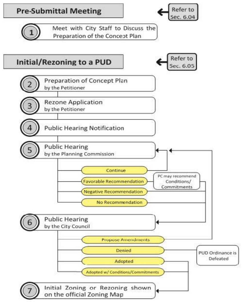
1)The section establishes procedures for the review, approval and development of a Planned Unit Development District. There are four basic steps in the PUD process which are illustrated in sequence in the flow charts on the following pages and which are described below:
a)Pre-Submittal Conference. The applicant is encouraged to engage in informal consultations with the Dallas Community Development staff prior to preparing plans.

The purpose of this meeting is to discuss expectations, schedule, concept and standards contained herein. It shall be understood that no statement or representations by a member of Staff shall be binding upon either the Council or upon any zoning body.

b)PUD District Ordinance and Concept Plan. Providing details to the city of the proposed PUD in the form of a “PUD Booklet” that includes a Concept Plan, elevation drawings, a letter of intent, a PUD Ordinance, and other details as required by the Community Development Director, is the second step in the process for establishing a Planned Unit Development. During this step, the petitioner’s proposed development requirements for the Planned Unit Development are reviewed by the Planning & Zoning Commission and the City Council. The approved standards are codified in a PUD District Ordinance that has the effect of rezoning the subject property to a Planned Unit Development zoning district, and establishing the development requirements that will be applied in all subsequent reviews. A Concept Plan, sample elevations and a letter of intent which accompanies the ordinance provides the Planning & Zoning Commission and City Council with a general vision for the development of the site. The PUD Booklet shall be required to furnish appropriate detail for open space, amenities, densities, number of units, square footage of commercial space, street layout, height, architectural details and other information as requested.
c)Preliminary Plat. The Detailed Development Plan is the third step in the process. In this step, the applicant prepares an overall plan for the site which will be reviewed by staff, the Technical Advisory Committee. For a Planned Unit Development that is going to be subdivided, this step also serves as the Preliminary Plat.
d)Final Plat. The Final Plat is the final step in establishing a Planned Unit Development.

During this step, the petitioner’s specific plan for the entire site or a portion of the site is reviewed by the members of the Technical Advisory Committee. For a Planned Unit Development that is going to be subdivided, this step also serves as the Final Plat.

i)Options.
(1)Submission of a Preliminary Plat, processed in the manner described in this Chapter, and the subsequent submission of a Final Plat for any portion of the approved Preliminary Plat the applicant wishes to develop. The Final Plat submitted according to this option shall be processed in the manner described in this Chapter.
(2)Submission of a Final Plat without a Preliminary Plat, processed in the manner described in this Chapter.
§ 6.04

PRE-SUBMITTAL CONFERENCE

Sec. 6.04 – PRE-SUBMITTAL CONFERENCE

1)Prior to submitting a Planned Unit Development application, the petitioner shall meet with the Dallas Community Development staff to review the zoning classification of the site, review the regulatory ordinances and materials, review the procedures and examine the proposed use and development of the property. Department staff shall aid and advise the applicant in preparing the application and supportive documents as necessary.
§ 6.05

PUD DISTRICT ORDINANCE AND CONCEPT PLAN

Sec. 6.05 – PUD DISTRICT ORDINANCE AND CONCEPT PLAN

1)ORIGINATION OF PROPOSALS. Any applicant may propose a Planned Unit Development district in accordance with the procedures established in this chapter. The applicant shall submit an application and fee for a Planned Unit Development in accordance with this section, Section 6.03 –Procedure Summary, and the established procedure of the Community Development department. The applicant shall refer to the application packet to determine the format and number of copies of the plans to be delivered.
2)AREA REQUIREMENTS. The minimum land area required for a Planned Unit Development shall be five (5) acres. However, a development of less than five (5) acres may be considered by the Planning & Zoning Commission for infill projects.
3)PROJECT OWNERSHIP. The project may be owned, leased, or controlled either by a single person or corporation, or by a group of individuals, or homeowner’s association. Such ownership may be a public or private corporation. However, if not under single ownership, the multiple owners must have a contractual agreement (1) not to develop the parcels separately, but in accordance with a single, unified plan, and (2) in which the separate owners have given their express intentions to enter into such private agreements and to assure its completion as planned and to the satisfaction of the Planning & Zoning Commission. The City Council may grant an extension of such time for such a period as it deems in the public interest.
4)DEVELOPMENT STANDARDS. In addition to the applicable provisions of this Ordinance, the PUD Ordinance must comply with the following requirements unless specifically waived by the City Council:
a)The Planned Unit Development must be substantially completed within the period of time specified in the schedule of development submitted by the developer.
b)The Planned Unit Development will address the public health, safety, and general welfare.
c)All uses are subject to the discretion and approval of the City Council.
d)At least 10% of all land area within the PUD shall be developed for commercial uses.

The City Council may wave this requirement.

e)The PUD Ordinance shall address the impact on traffic and public services and facilities, such as schools, fire and police protection. A Fiscal Impact Analysis shall be required for developments of one-hundred fifty (150) or more residential units. The Planning & Zoning Commission may also request a Fiscal Impact Analysis or a traffic study for projects under one-hundred fifty (150) units at their discretion. These studies shall address the impact of the proposed Planned Unit Development on all adjacent streets and intersections.
f)The PUD Ordinance shall contain such proposed covenants, easements and other provisions relating to the proposed development standards, as reasonably are required for public health, safety and general welfare. A Home Owners Association or other active management is required for all residential developments.
g)Gross residential density shall be calculated by dividing the gross acreage of the total development area by the size of the recommended lots to determine total dwelling units per acre in the proposed project.
h)Open Space shall be required in accordance with Section 7.13 –Open Space Requirements.
i)The preliminary and final plat shall be substantially similar to the PUD Booklet and Concept Plan in, number of units, commercial/industrial square footage, street layout, density, and height of structures, parking layout, and pedestrianism pursuant to Section 6.11 – Amendments to the Concept Plan and Final Plat.
5)PUD BOOKLET REQUIREMENTS
a)The PUD Booklet shall address all of the development standards contained within, and may defer to, the City of Dallas Zoning Ordinance. Should the PUD Ordinance not address specific development standards and subsections as set forth within Section 7 and Section 9 of this ordinance, then those standards shall apply. At a minimum, the following requirements should be addressed:
i)Location, size, orientation and shape of buildings;
ii)Building materials and appurtenances;
iii)Parking;
iv)Signage;
v)Exterior renovation or altering of existing structures;
vi)Demolition of existing structures;
vii)Landscaping;
viii)Environmental and natural resource protection;
ix)Erosion and sedimentation control;
x)Vehicular and pedestrian circulation;
xi)Outdoor lighting;
xii)Minimum lot area;
xiii)Minimum lot frontage;
xiv)Minimum lot width;
xv)Minimum front setback;
xvi)Minimum side setback;
xvii)Minimum rear setback;
xviii)Maximum height of structures (principal and accessory);
xix)Maximum lot coverage;
xx)Minimum floor area;
xxi)Site access;
xxii)Site screening and buffering;
xxiii)Location of dumpsters; and
xxiv)Location of open spaces.
6)REVIEW
a)The Community Development department shall determine that the PUD District Ordinance and Concept Plan application are a complete submittal. The Department shall:
i)Docket Number. Assign the item a docket number;
ii)Planning & Zoning Commission. Place the item on an agenda of the Planning & Zoning Commission for public hearing; and
iii)Notification. Inform the petitioner of the time, date, and place of the hearing.
iv)Record. The Department shall maintain records of all applications, plans, and permits filed for a PUD District Ordinance and Concept Plan.
7)PLANNING & ZONING COMMISSION
a)Public Notice. The Community Development department shall be responsible for posting public notice pursuant to the Planning & Zoning Commission Rules of Procedure.
b)Public Hearing. A public hearing shall be held in accordance with the Planning & Zoning Commission Rules of Procedure and the Ordinance draft, concept plan and testimony of the applicant and other attendees shall be considered.
c)Decision. The Planning & Zoning Commission shall:
i)Certify and forward the petition to the City Council with:
(1)A favorable recommendation;
(2)A negative recommendation;
(3)No recommendation; or
(4)Continue the petition to a definite future meeting date.
d)Commitments. In conjunction with its recommendation to the City Council regarding a PUD District Ordinance and Concept Plan, the Planning & Zoning Commission may recommend that the City Council permit the petitioner to make written commitments and may recommend that the Council impose conditions of approval concerning the use or development of the parcel.
e)Revisions. Following Planning & Zoning Commission approval, the petitioner shall submit revised copies of the PUD District Ordinance and the Concept Plan that address the comments and concerns of the Planning & Zoning Commission.
8)CITY COUNCIL
a)Decision. The City Council shall:
i)Adopt the PUD District Ordinance and Concept Plan;
ii)Adopt the PUD District Ordinance and Concept Plan with conditions and/or commitments;
iii)Return the PUD District Ordinance and Concept Plan to the Planning & Zoning Commission with proposed amendments; or
iv)Deny the PUD District Ordinance and Concept Plan.
b)Meaning of Approval. Approval of the PUD District Ordinance by the City Council shall act as a zoning map amendment and an overall guide for the Planned Unit Development, setting forth concepts that shall be consistent in the Preliminary Plat and Final Plat.
c)Commitments. The applicant shall prepare the commitment instrument in a form approved by the City Attorney. The petitioner and the Mayor and City Council shall sign the commitment instrument.
9)Recording. The petitioner shall record the commitment instrument in the County Recorder’s office within thirty (30) days of the approval of the PUD District Ordinance and Concept Plan. The petitioner shall deliver a copy of the recorded commitment instrument to the Community Development department before filing a Preliminary Plat petition. This commitment shall be transferrable per Section 6.12 Transferability.
10)Modification or Termination. A commitment or conditions of approval made under this section may be modified or terminated only by a decision of the City Council at a public hearing.
11)Enforcement. The City may enforce any commitment or condition of approval as if the commitment were a standard of the Dallas Zoning Ordinance.
§ 6.06

PRELIMINARY PLAT PROCEDURE

Sec. 6.06 – PRELIMINARY PLAT PROCEDURE

1)PURPOSE. The purpose of a Detailed Development Plan is to divide land into lots, blocks and common area.
2)APPLICATION. An application for Preliminary Plat shall be filed with the Community Development Director by the owner, or his/her designee, of property for which the Planned Unit Development is proposed. The applicant shall refer to the application packet to determine the format and number of copies of the plans to be delivered and the application shall be in accordance with the established procedures of the Community Development department indicated in Chapter 34 Subdivisions of the Dallas Code of Ordinances and shall contain, at a minimum, the following information:
a)Name, address, and phone number of applicant;
b)Name, address, and phone number of registered surveyor or registered engineer assisting in the preparation of the Preliminary Plat;
c)A survey of the tract that is to be developed;
d)Description of existing use;
e)Identification of the existing zoning district;
f)A vicinity map at a scale approved by the Technical Advisory Committee, showing existing property lines, streets, existing and proposed zoning, and such other items as the Technical Advisory Committee may require to show the relationship of the Planned Unit Development to the Comprehensive Plan and to existing developments, schools and other community facilities and services;
g)A Preliminary Plat at a scale approved by the Technical Advisory Committee showing topography at two (2) foot intervals; the approximate location and type of residential, commercial and industrial land uses; layout, dimensions, and names of existing and proposed streets, rights-of- way, utility easements, parks and open spaces; layout and dimensions of lots and building setback lines, areas of proposed buffering; preliminary improvement drawings showing: points of ingress/egress, water, sewer, drainage, electricity, telephone, and such other characteristics as the Technical Advisory Committee deems necessary;
h)Proposed schedule for the development of the site, identifying phasing where applicable;
i)Evidence that the applicant has sufficient control over the land in question to initiate the proposed development plan within five (5) years; including a statement of all the ownership and beneficial interests in the tract of land and the proposed development;
j)In the case of a residential planned unit development, the proposed density to which the Development shall be limited; and
k)In the case of office, commercial, industrial, or mixed-use planned unit development, a statement identifying the principal type of office, business, industrial, and/or other uses that are to be included in the proposed development.
3)TECHNICAL ADVISORY COMMITTEE. Once the Department has determined that it has received a submittal that is sufficiently complete for Technical Advisory Committee (TAC) review, the Department shall inform the petitioner of the time, date, and place of the meeting. Following TAC review, the applicant shall submit revised copies of the plans that address the comments and concerns of the TAC.
4)TECHNICAL ADVISORY COMMITTEE REVIEW AND APPROVAL
a)After receipt of the Preliminary Plat, the Technical Advisory Committee shall hold a meeting within a reasonable period of time.
b)The Technical Advisory Committee shall review the preliminary plan to determine if the Proposed Planned Unit Development is:
i)Consistent with the intent and purpose of this Ordinance;
ii)Whether the proposed development advances the general welfare of the community and neighborhood; and
iii)Whether the benefits, combination of various land uses, and the interrelationship with the land uses in the surrounding area justify the deviation from standard district regulations.
c)The Technical Advisory Committee's approval in principle of the primary development shall be necessary before an applicant may submit a Final Plat.

Approval in principle shall not be construed to endorse the following:

i)A precise location of uses;
ii)Configuration of parcels;
iii)Engineering feasibility.
5)EXPIRATION. The Preliminary Plat approval shall expire in five (5) years unless final approval of all or part of the development is complete.
§ 6.07

DEVELOPMENT PLAN

Sec. 6.07 – DEVELOPMENT PLAN

1)Development plan requirements. Following the approval of a preliminary plat of a proposed subdivision, the subdivider shall submit development plans and supporting data. The development plans, prepared by a registered land surveyor or civil engineer, shall meet the higher minimum standards of design set forth in this article and/or those required by O.C.G.A. § 44-3-3 as now or hereafter amended and shall include the following information:
a)Generally.
i)Proposed name of subdivision.
ii)Name and address of person to be notified of action.
iii)Date of survey, north point and graphic scale, source of datum, date of plat drawing and space for revision dates.
iv)Location sketch map showing the relationship of the subdivision to the surrounding area.
v)Location (land lot and district) and gross acreage of tract.
vi)Exact boundary lines of the tract indicated by a heavy line giving lengths and bearings. The boundary lines shall include the entire tract to be eventually subdivided and data as required herein shall apply to the entire tract. In the event that the entire tract to be developed is not submitted, provide master plan and additional data to support immediate development in order to ensure proper overall planning.
vii)The development plan shall be drawn to a scale of not less than one-inch equals 100 feet on a sheet or equal sized sheets. If the complete development plan cannot be shown on one sheet, then several sheets with an index map on each sheet shall be used. In no case shall sheet size be smaller than eight and one-half inches by 11 inches, or larger than 24 inches by 36 inches.
viii)Name of former subdivision if the development has been previously subdivided.
ix)Water and sewer availability in accordance with local and state regulations.
2)Existing conditions.
a)Topography by contours shall be required as follows:
i)On land with less than approximately two percent slope, show contours at intervals of not more than one foot;
ii)On land with slopes greater than approximately two percent, show contours with an interval of not more than two feet;
iii)Contours shall be based on the datum plane of the U.S. Coast and Geodetic Survey.
b)Zoning district classifications of land to be subdivided and classifications of adjoining properties.
c)Recorded deed names of adjoining property owners or subdivisions.
d)In case of resubdivision, a copy of existing plat with proposed resubdivision superimposed thereon.
e)Location of significant features, streams (including applicable state and local stream buffers and impervious setbacks), wetlands, ponds, lakes, swamps and land subject to floods, including any area having an elevation below the 100-year floodplain. Where lots contain some areas with an elevation below the 100-year floodplain, a showing of a viable home site above such floodplain elevation. Any lot having no such viable home site shall be properly filed to provide same before final plat approval and must be in accordance with U.S. Corp of Engineers' requirements.
f)Location of existing adjoining property lines and buildings on the property to be subdivided.
g)Location, names, and right-of-way of streets, roads, railroads and utility lines either on or adjacent to the property to be subdivided. Specify whether utility lines are in easements or rights-of-way and show location of poles or towers.
h)Size and location of existing sanitary sewers, water mains, storm sewers, drains, culverts and location of easements for other underground facilities within the tract or within the right-of-way of streets or roads adjoining the tract. Grades and elevations of sewers are to be shown.
i)The acreage of each drainage area affecting the proposed subdivision.
j)All elevations shall refer to the mean sea level datum where public water and/or public sewers are to be installed.
k)Preliminary soil erosion and sedimentation control plan in accordance with the specifications and requirements of Chapter 16, Article IV, pertaining to erosion and sedimentation control, if applicable.
3)Proposed conditions.
a)Plan and profile of streets, roads, and sidewalks showing widths, road names, and a typical road section inclusive of sidewalks where required.
b)Topography by contours of proposed streets, drainage ditches and other improvements as provided in subsection (a)(1) of this section.
c)Layout of all lots, including building setback lines; scaled dimensions on lots; utility easements with width and use; acreage of each lot; lot numbers and block numbers; and drainage. No lot numbers shall be duplicated.
d)Plan and profile of sanitary sewers (if applicable) with grade, pipe size, material, and point of discharge.
e)Plan and profile of storm sewer system with grade, pipe size, material, and location of outlets, inlets, and stormwater management facilities.
f)Plan of water supply system with pipe sizes and location of hydrants. Water system shall be designed to furnish a minimum of 25 psi and maximum demand flow of 15 gallon/minute to each building. All water mains shall be a minimum of eight inches in diameter.
g)Designation of all land to be reserved or dedicated for private and/or public use.
h)Proposed phase division or stage development, if any, as proposed by the subdivision developer.
i)Site grading plan with soil sediment control structures, as required.
j)A plan of street lighting must be shown as determined by the utility power company serving the area.
4)Development plan review and approval. Within 45 days after the submission of the development plan, the city manager or his/her designee shall review and approve, conditionally approve, or disapprove the plan. One copy of the plan shall be returned to the developer with notice of the approval, conditional approval or disapproval with the reasons thereof.
5)Effective period of development plan approval.
a)Approval of the development plan shall lapse unless a final plat of all or part of the area shown on the development plan is submitted within two years from the date of approval by the city manager or his/her designee, unless an extension of time is requested by the developer and approved by the city manager or his/her designee.
b)Approval of the development plan shall lapse and have no force and effect unless actual construction of required improvements have been commenced within 12 months of the approval by the city manager or his/her designee.
c)Notwithstanding the provisions of this article, a developer operating under a previously approved preliminary plan may continue to submit final plats in conformance therewith, provided that the approved preliminary plan is an active preliminary plan. Preliminary plans may be deemed inactive if a final plat for a portion thereof has not been submitted to the city manager or his/her designee within the past two years of the adoption of the ordinance from which this article is derived.
6)Land disturbing permit. Upon approval of the development plan by the city manager or his/her designee, a land disturbing permit may be issued, upon request, by the city manager or his/her designee to cover the following construction phases, provided that all soil erosion and sedimentation control structures are in place:
a)Grading, clearing and grubbing;
b)Storm drainage construction;
c)Water and sewer line construction;
d)Curbing construction;
e)Base and paving construction.
7)Environmental compliance. Prior to issuance of a land disturbance permit by the city, the owner shall provide to the city proof of compliance with other applicable state and federal environmental regulations including a Notice of Intent to the Georgia Environmental Protection Division for NPDES General Permit and, if applicable, Preconstruction Notification to the U.S. Army Corps of Engineers.
8)Restrictive covenants. If the owner places restrictive covenants on any land or use thereof within the subdivision greater than those required by the ordinances of the city, such restrictive covenants, or reference thereto, may be required to be indicated on the final plat, or recorded with the deeds as filed with the clerk of the superior court of the county in a form approved by the city attorney.
9)Filing fee. In order to process the application, a filing fee in an amount as set forth in the schedule of fees and charges on file in the office of the city clerk shall be submitted with each development plan. Said fee is to defray the cost of advertising, meetings, review process, and site visits as examples of expenses.
§ 6.08

FINAL PLAT

Sec. 6.08 – FINAL PLAT

1)PURPOSE. The purpose of a Final Plat is to provide the details for the construction of individual portions of the PUD. Typical construction plans are submitted and final plats are recorded.
2)SUBMISSION. After approval of the Preliminary Plat and construction drawings, the developer shall submit a Final Plat in accordance with established procedures of the Community Development department. The Final Plat shall be in general conformance with the Preliminary Plat as approved by the City Council. The Final Plat shall be certified by a registered engineer or land surveyor.
3)APPLICATION. An application for approval of the Final Plat shall be filed with the Community Development Director by all owners, or their designee, of the property for which the Planned Unit Development is proposed. Each application shall be signed by the owner, attesting to the truth and exactness of all information supplied on the application for Final Plat. Approval shall expire and may be revoked if construction on the project has not begun within two (2) years from the date of issuance of the approval and such requirement shall be clearly stated on the application. At a minimum, the application shall contain the following information:
a)Any changes necessary to the survey of the proposed development site, showing the dimensions and bearing of the property lines, area in acres, topography, existing features of the development site, including major wooded areas, structures, streets, easements, utility lines and land uses;
b)All information required on the Preliminary Plat, the location and sizes of lots, location and proposed density of dwelling units, nonresidential building intensity, and land use considered suitable for adjacent properties;
c)A schedule for the development of units to be constructed in progression and a description of the design principles for buildings and streetscapes, tabulation of the number of acres in the proposed project for various uses, the number of housing units proposed by the type, estimated residential population by type housing.

Estimated nonresidential population, anticipated timing for each unit, and standards for height, open space, building density, parking areas, population density and public improvements proposed for each unit of the development, whenever the applicant proposes an exception from standard zoning districts or other Ordinances governing development;

d)Engineering feasibility studies and plans showing, as necessary, water, sewer, drainage, electricity, and telephone, waste disposal facilities, street improvements, and nature and extent of earth work required for site preparation and development;
e)Development plan, showing buildings, various functional use areas, circulation, and their relationship;
f)Preliminary building plans, including floor plans and exterior elevations; Landscaping plans;
g)When a Planned Unit Development is to be constructed in stages or units, a schedule for the development of such stages or units shall be submitted. When a Planned Unit Development provides for common open space, the total area of common open space provided at any stage of development shall, at a minimum, bear the same relationship to the total open space to be provided in the entire Planned Unit Development as the stages or units completed or under development bear to the entire Planned Unit Development;
h)When a Planned Unit Development includes provisions for common open space or recreational facilities, a statement describing the provision that shall be made for the care and maintenance of such open space or recreational facilities. If it is proposed that such open space be owned and/or maintained by any entity other than a governmental authority, copies of the proposed Chapters of incorporation and bylaws of such entity shall be submitted;
i)Deed restrictions, and restrictive/protective covenants, and other legal statements or devises to be used to control the use, development and maintenance of the land, and the improvements thereon, including those areas which are to be commonly owned and maintained;
j)Evidence that the applicant has sufficient control over the land in question to initiate the proposed development plan within five (5) years; including a statement of all the ownership and beneficial interests in the tract of land and the proposed development; and
k)One (1) copy of the Preliminary Plat.
4)REVIEW
a)Review. The Technical Advisory Committee shall review Final Plats at a regular meeting. This shall not be a public hearing.
b)TAC Review Criteria. Before taking action, TAC shall find that the facts submitted with the application and presented at the public hearing establish that:
i)The proposed development can be initiated within two (2) years of the date of approval;
ii)Each individual unit of the development, as well as the total development, can exist as an independent unit capable of creating an environment of sustained desirability and stability or that adequate assurance will be provided that such objective will be attained, the uses proposed will not be detrimental to present and potential surrounding uses, but will have a trespass
iii)Beneficial effect which could not be achieved under standard district regulations;
iv)The streets as proposed are suitable and adequate to carry anticipated traffic, and increased densities will not generate traffic in such amounts as to overload the street network outside the Planned Unit Development;
v)The streets as proposed are suitable and adequate to carry anticipated traffic, and increased densities will not generate traffic in such amounts as to overload the street network outside the Planned Unit Development;
vi)Any proposed commercial development can be justified at the locations proposed;
vii)Any exception from standard district requirements is warranted by the design and other amenities incorporated in the Final Plat, in accordance with the Planned Unit Development;
viii)The area surrounding the development can be planned and zoned in coordination and substantial compatibility with the proposed development;
ix)The Planned Unit Development is in general conformance with the Comprehensive Plan of the City;
x)The existing and proposed utility services are adequate for the commercial uses provided; and
xi)The proposed open spaces are adequate and appropriate as identified in this Chapter.
c)Action.
i)The Technical Advisory Committee shall take action to:
(1)approve as presented;
(2)approve with supplementary conditions; or
(3)disapprove.
ii)Following Technical Advisory Committee review, the applicant shall submit revised copies of the plans that address the comments and concerns of the Technical Advisory Committee. The applicant shall refer to the application packet to determine the format and number of copies of the plans to be delivered.
5)APPEAL OF A DECISION OF THE DIRECTOR OF THE COMMUNITY DEVELOPMENT DEPARTMENT. The decision of the Community Development Director can be appealed by the Dallas City Council in accordance with Section. 11.11 - Administrative Appeals Procedure.
6)COMMERCIAL PROJECTS. For a Planned Unit Development that is being subdivided, approval of the Final Plat shall be considered to be the Secondary Plat for recording purposes. Subdivision plat procedures/approval may coincide with, and be approved at the same time as, the Preliminary Plat and the Final Plat.
7)COMMENCEMENT OF CONSTRUCTION. No construction or site grading shall begin prior to the issuance of a Land Disturbance Permit. No Zoning Certificate shall be issued for any property for which a Planned Unit Development classification is requested and no construction shall begin until an approved Final Plat is in effect for that phase or property, whichever of the above options is chosen by the applicant. No improvement location permit shall be issued for any structure in any portion of a Planned Unit Development unless and until the final subdivision plat for that portion has been approved by the proper planning authority and recorded in the public record of the City. This requirement may be waived by the Director when it is deemed that a subdivision plat is not required.
§ 6.09

ALTERNATIVE SUBMISSION FOR FINAL PLAT

Sec. 6.09 – ALTERNATIVE SUBMISSION FOR FINAL PLAT

1)APPLICATION. The applicant need not file a Preliminary Plat if filing a Final Plat for the entire site, incorporating all requirements of both the Preliminary and Final Plats as described in this Section. The Final Plat shall be filed with the Community Development Director by at least one (1) owner, or his/her designee, of the property for which the Planned Unit Development is proposed. Each application shall be signed by the owner, attesting to the truth and exactness of all information supplied on the application for Final Plat. At a minimum, the application shall contain the following information:
a)A survey of the tract that is to be developed showing existing features of the property including streets, alleys, easements, utility lines, existing land use, general topography and physical features;
b)A development plan showing the location and arrangement of all existing and proposed structures, the proposed traffic circulation pattern within the development, the areas to be developed for parking, the points of ingress and egress including streets where required the relationship of abutting land uses and zoning districts, proposed lots and blocks, if any, and proposed public or common open space, if any, including parks, playgrounds, school sites and recreational facilities, screening, and areas to be left in their natural state;
c)A statement of the proposed total gross floor area, and the percentage of the development which is to be occupied by structures;
d)Floor plans of the proposed structures; Landscaping plans;
e)When a Planned Unit Development is to be constructed in stages or units, a schedule for the development of such stages or units shall be submitted. When a Planned Unit Development provides for common open space, the total area of common open space provided at any stage of development shall, at a minimum, bear the same relationship to the total open space to be provided in the entire Planned Unit Development as the stages or units completed or under development bear to the entire Planned Unit Development;
f)Evidence that the applicant has sufficient control over the tract to affect the proposed plan, including a statement of all the ownership and beneficial interests in the tract of land and the proposed Development;
g)In the case of a residential planned unit development, the proposed density to which the Development shall be limited;
h)In the case of Office, Commercial, or Industrial, a statement identifying the principal type of office, business and/or industrial uses that are to be included in the proposed Development;
i)When a Planned Unit Development includes provisions for common open space or recreational facilities, a statement describing the provision that is to be made for the care and maintenance of such open space or recreational facilities. If it is proposed that such open space be owned and/or maintained by any entity other than a governmental authority, copies of the proposed Chapters of incorporation and bylaws of such entity shall be submitted; and
j)Copies of any restrictive covenants that are to be recorded with respect to property included in the Planned Development District.
2)EXPIRATION. Approval shall expire and may be revoked if construction on the project has not begun within two (2) years from the date of issuance of the approval and such requirement shall be clearly stated on the application.
§ 6.10

TIME LIMIT FOR APPROVED PUD MASTER PLAN

Sec. 6.10– TIME LIMIT FOR APPROVED PUD MASTER PLAN

1)In the event that a PUD Master Plan is given approval, and the landowner(s):
a)Fail to obtain approval for improvement plans or a development order for all infrastructure improvements to include utilities, roads and similar improvements required by the approved PUD Master Plan or other development orders for at least fifteen (15 %) percent of the gross land area of the PUD site every five (5) years of the date of approval by the Dallas City Council; and/or
b)Fail to receive final local development orders for at least fifteen (15%) percent of the total number of approved dwelling units in the PUD, or in the case of PUD’s consisting of non- residential uses, thirty (30%) percent of the total approved gross leasable floor area within the PUD every six (6) years of the date of approval by the Dallas City Council.
2)The project developer shall submit to the Community Development Director a status report on the progress of development annually commencing on the fifth anniversary date of the PUD approval by the City Council. The singular purpose of the report will be to evaluate whether or not the project has commenced in earnest in accordance with the criteria set forth above.
3)Should the Director determine that the development has commenced in earnest, then upon review and consideration of the report provided by the owner and any supplemental information that may be provided, the City Council shall elect one of the following:
a)To extend the current PUD approval for a maximum period of two (2) years; at the end of which time, the owner will again submit to the procedure as defined herein.
b)Require the owner to submit an amended PUD in which the unimproved portions of the original PUD shall be consistent with the Comprehensive Plan. The existing PUD shall remain in effect until subsequent action by the Council of the submitted amendment of the PUD.
c)If the owner fails to submit an amended PUD within six (6) months of Council action to require such an amended submittal, then the Council may initiate proceedings to rezone the unimproved portions of the original PUD to an appropriate zoning classification consistent with the procedures in Section 11.05 – Zoning Map and Text Amendments.
§ 6.11

PUD ABANDONMENT

Sec. 6.11 – PUD ABANDONMENT

1)In the event of the abandonment of a Planned Unit Development authorized under this section, the City Council may initiate an amendment to the Zoning Ordinance so that the land will be zoned into a category or categories which approximates its existing use or such other zoning category or categories which it deems appropriate.
2)Abandonment shall be deemed to have occurred when no improvements have been made pursuant to the approved Final Plat for twenty-four (24) consecutive months. The twenty-four (24) month time limitation may be extended at the discretion of the City Council.
§ 6.12

AMENDMENTS TO THE CONCEPT PLAN AND FINAL PLAT

Sec. 6.12 – AMENDMENTS TO THE CONCEPT PLAN AND FINAL PLAT

1)No changes shall be made in the approved Concept Plan or plats unless in conformance with the following requirements. The term "minor changes" as used in this section is considered to represent changes that do not alter the overall characteristics of the total plan and that create no adverse impacts on adjacent uses or public services and facilities. Some examples of what can be considered as minor changes are:
a)Minor Change. The Community Development Director may authorize minor changes under the following conditions:
i)Changes in location and type of landscaping and/or screening so long as the approved character and intent is maintained;
ii)Changes in the orientation of portions of parking areas so long as the effectiveness of the overall site circulation and parking is maintained; parking areas shall be relocated not closer than twenty (20) feet to any residential structure or ten (10) feet to any street or right-of-way lines; and the number of parking spaces shall not be reduced by the relocation;
iii)Changes in the location of sidewalks and pathways, provided that continuity of pedestrian circulation remains;
iv)The reorientation, but not complete relocation of structures;
v)Changes that will not impact properties or uses outside of and adjacent to the PD; or
vi)Redesign of open space that does not decrease the recreational, buffering, or environmental benefits of the open space.
b)Prohibitions. No minor change authorized by this section may cause any of the following:
i)Change in the permitted uses or of development character;
ii)increased overall coverage of structures;
iii)increased density or intensity of use;
iv)increased demand for traffic circulation and public utilities;
v)decrease in public or private open space;
vi)decrease in pavement and sidewalk widths; or
vii)increased numbers of dwellings.
c)Major Change. All other changes to the approved Concept Plan or plats shall be deemed "major" and shall be approved only by the Council after review of a revised Final Development Plan and/or Map. No amendments may be made in the approved Final Development Plan unless the applicant establishes that such amendments are required as a result of:
i)changes in conditions that occurred after Final Development Plan approval;
ii)changes in the development policy of the community; or
iii)conditions that were reasonably unforeseen at the time of Final Development Plan approval.
2)Recording of Changes and Amendments. Any changes that are approved for the Final Development Plan and/or Final Plat shall be recorded as amendments to the previously recorded Plan and/or Map.
§ 6.13

TRANSFERABILITY AND ENFORCEMENT OF STANDARDS

Sec. 6.13 – TRANSFERABILITY AND ENFORCEMENT OF STANDARDS

1)All commitments, conditions, stipulations, ordinance requirements, PUD Booklets, Concept Plans, and PUD Ordinances are shall be entered into the legal record by filing in the County Recorder’s Office.
2)All future developers, owners, builders, applicants, successors and assigns shall be bound by all commitments, conditions, ordinance requirements, PUD Booklets, Concept Plans, Plats, and PUD Ordinances from any annexation, rezoning, variance or special exception unless relief is granted by the City Council.
3)Applicant/Developer/Owner agrees and acknowledges that all conditions or stipulations of re-zoning shall bind applicant/developer/owner’s successors and assigns.
Figure 6.2: Preliminary/Final Plat Flow Chart
Rebuilt from the published figure · verify at source
*If denied by the TAC, an appeal can be made to the City Council per Section 11.11.

Application Completeness Review Technical Advisory Committee Meeting Technical Advisory Committee.

CHAPTER VII – DEVELOPMENT STANDARDS