Chapter 400 — Land Development, Article 1 — Streets and Public Improvements
General
Chapter 400. Land Development Table of Contents
Article 1. Streets and Public Improvements ........................................................ 400-2

Article 2. Grading, Erosion, and Sedimentation ................................................ 400-47

Article 3. Environmental Protection .................................................................. 400-65

Article 4. Stormwater ...................................................................................... 400-105
Chapter 400. Land Development Article 1. Streets and Public Improvements Table of Contents
Sec. 401-1. General .......................................................................................... 400-3

Sec. 401-2. Open Space .................................................................................... 400-7

Sec. 401-3. Blocks and Access ........................................................................ 400-18

Sec. 401-4. Streetscapes ................................................................................ 400-24

Sec. 401-5. Streets.......................................................................................... 400-28
Chapter 400. Land Development Article 1. Streets and Public Improvements General Applicability This article applies to any development permit, land disturbance Permit, or building permit.
Intent The article is intended to promote good subdivision and site design that:
Creates a functional and attractive development for future inhabitants and users;
Minimizes adverse impacts on adjoining properties and residents;
Minimizes adverse impacts on the natural environment; and Ensures that a project will be an asset to the community.
Land Suitability and Site Analysis Primary Conservation Areas
Secondary Conservation Areas
Site Analysis Map Required
The development of the site must be based on the site analysis. To the maximum extent practicable, development must be located to preserve natural features, to avoid areas of environmental sensitivity, and to minimize negative impacts and alteration of natural features.
Offers of Land Dedication When a developer proposes the dedication of land to public use, and the reservation is not envisioned in the Comprehensive Plan or is otherwise deficient, the Director must obtain approval for the proposed reservation of land from the City Council before approval of the preliminary plat. If the Director finds that such land is neither required nor suitable for public use, the Director will require the rearrangement of lots to include such land in private ownership.
Required Public Improvements Improvements and associated lands required by this article must be provided at no cost to the City and must be dedicated or otherwise transferred, as required, to the public in perpetuity and without covenant or reservation, except as otherwise provided herein.
Survey Monuments Marker requirements.
All lot corners must be marked with an iron rebar or pin, at least 0.5 inch in diameter and 18 inches long and driven to extend no less than 1 inch above the finished grade.
Floodplains On subdivisions containing floodplains, flood elevation references must be set in accordance with the requirements of the Flood Damage Prevention Ordinance.
Standard drawings Maintenance The Department must maintain a set of Snellville and Gwinnett County Department of Planning and Development standard drawings on file for consultation and distribution. These drawings illustrate details of the construction and design of streets, stormwater drainage facilities, site improvements, and other elements related to the development of land in accordance with this UDO.
Case-by-Case Basis The standard drawings provide minimum acceptable standards for land development activities authorized under this article and this UDO, but will not supersede more restrictive prudent design requirements or good engineering practice as may be applied by the Director to specific situations on a case-by-case basis.
Minimum standards The standard drawings are incorporated by reference as part of this UDO and establish the minimum standards for design and construction of required improvements, subject to the amendment and appeal provisions of Chapter 100 Article 3.
Open Space
Open Space Open Space Conservation Applicability This subsection applies to the following developments and is in addition to any recreation areas required by Sec. 401-2.2:
Intent The intent of this subsection is to require applicable new developments to provide open space, in order to achieve the following purposes:
Existing Features Subject to the review of the City Council, the Director may require that existing features which would add value to the planned development or to the city as a whole, such as trees, watercourses and falls, historic sites, and similar irreplaceable assets, be preserved.
Open Space Requirement
Open Space Standards Open space required to meet the minimum requirements must comply with the following:
This includes concrete located in retention or detention ponds, spillways, or basins;
Conservation Surety
Ownership Requirements Open space must be owned in fee-simple by a property owner's association; by the property owners; or by another entity approved in advance by the City. The developer must record the deed to the open space before, or concurrent with, the recording of the first final subdivision plat. An access easement following the alignment of future public streets is acceptable. However, "greens" may be deeded concurrent with the unit or phase of the final subdivision plat of which it is a part.
Property Owner’s Association When a property owner’s association is established, its bylaws must include the following:
and compulsory assessments.
Maintenance
Tax assessment of open space When a legal instrument for permanent protection has been placed upon the open space, the City must reassess the open space at a lower value to reflect its more limited use. If the open space is used purely for passive recreational purposes and the terms of the instrument for permanent protection effectively prohibit any type of significant economic activity, then the assessment must be at a value of zero.
Recreation Areas Applicability This subsection applies to the following and is in addition to any open space conservation required by Sec. 401-2.1:
General
The organization of a qualified property owners association and its adequate financing for the discharge of its responsibilities shall be assured through acceptable private deed covenants running with the land or other such documents as approved by City Council.
Civic Space Applicability
Civic Space
Its landscape must consist of paths and trees and may also include lawns and non-asphalt paved surfaces. The minimum size for a square is 0.5 acre.
Playgrounds must be interspersed within residential areas, may be placed within a block, and may be included in parks and greens. There is no minimum size for playgrounds.
Amenity Space
General
This includes concrete located in retention or detention ponds, spillways, or basins; and
Fee-in-Lieu If the required civic space cannot be provided on-site, the Director may approve a fee contribution to the City of Snellville Open Space Fund. The following standards are established for administering these contributions and fund:
Credit for Off-Site Public Open Spaces Developments within 500 feet of a public park or other public open space (measured in a straight line from the development lot line to the closest lot line of the park or open space) may use the area of such off-site open space to satisfy its open spaces requirements as follows:
Ownership Requirements Civic space, but not amenity space, must be owned in fee-simple by a property owner's association; by the property owners; or by another entity approved in advance by the City. The developer must record the deed to the civic space before, or concurrent with, the recording of the first final subdivision plat. An access easement following the alignment of future public streets is acceptable.
Property Owner’s Association When a property owner’s association is established, its bylaws must include the following:
and compulsory assessments.
Maintenance
Tax assessment of open space When a legal instrument for permanent protection has been placed upon the civic space, the City of Snellville must reassess the civic space at a lower value to reflect its more limited use. If the civic space is used purely for passive recreational purposes and the terms of the instrument for permanent protection effectively prohibit any type of significant economic activity, then the assessment must be at a value of zero.
Blocks and Access
Blocks and Access Intent The intent of the block standards is to provide a well-connected street network.
Large blocks with limited connectivity discourage walking, contribute to street congestion, and add driving distance that can negatively impact emergency services. New streets should be designed to consider future development.
The intent of access standards is to provide safe and convenient vehicular and pedestrian access within developments and between adjacent developments and to lessen traffic congestion and increase connectivity. Pedestrian, bike, and vehicular access should be safe, direct, and convenient.
Blocks Layout The lengths, widths, and shapes of blocks shall be determined with regard to:
and
Measurement
Town Center Overlay, Town Center Districts, NR District, MU District
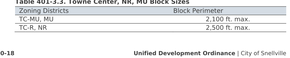
Any lot or site required to provide minimum frontage by the zoning district in which it is located must provide vehicular access directly from a public street or public alley built to the standards in these regulations except as provided in paragraph G below (Vehicular Access Easements).
Subdivisions
Town Center Overlay, Town Center Districts, NR District, MU District
Access Improvements for Single-Family Attached Subdivisions and Residential Subdivisions
Access Improvements for Multifamily and Nonresidential Developments
Dead End Streets
In no case may a dead end street exceed 2,000 feet in length unless approved by the Director due to unusual topographic conditions or property configurations.
Vehicular Access Easements
The property must be served by an exclusive access easement which must be limited to the provision of access to only one principal use or structure.
Inter-parcel Access
Pedestrian and vehicular access is contingent upon the granting of reciprocal vehicular, bicycle and pedestrian access rights to the granting property;
Streetscapes
Streetscapes General Applicability Streetscapes must be installed when one or more of the following applies:
Exceptions Streetscapes are not required to be installed when one or more of the following applies:
Administrative Variances The Director may grant administrative variances to the requirements of this section when one or more of the following applies:
or
Location Standards When streetscapes are required, they must be installed:
State Routes
Streetscapes Required General
| Street Type and | Zoning & Overlay District | Development Type | Planter | Sidewalk |
|---|---|---|---|---|
| Local | All districts except TC-R, TC-MU, NR, MU | Residential Subdivision | 5 ft. min. | 4 ft. min. |
| Local | TC-R, NR, MU | All development types | 5 ft. min. | 6 ft. min. |
| Local | TC-MU, TCO | All development types | 5 ft. min. | 10 ft. min. |
| Principal Arterial, Major Arterial, Minor Arterial, Major Collector | All districts except TC-R, TC-MU, MU | All development types | 5 ft. min. | 6 ft. min. |
| Principal Arterial, Major Arterial, Minor Arterial, Major Collector | TC-R, TC-MU, TCO, MU | All development types | 5 ft. min. | 10 ft. min. |
| Alley | All districts | All other development types | Not required | Not required |
provided below.
The entire planting area must be planted with evergreen ground cover or a tree grate must be installed.
207-3.2.
Design Standards All streetscapes that are required or installed must conform to the following unless an administrative variance is granted by the Director.
Streets trees must be located in the planter in conformance with Sec. 207-3.4.
Concrete curb and gutter are required where streetscapes are installed.
Sidewalks must be constructed of concrete and must be a minimum of 4 inches thick. The concrete must be class "B" (as defined by GDOT) and have a strength of 2,200 psi at 28 days.
All new sidewalks must match and provide a smooth transition to any existing sidewalks with no steps. Curb ramps must be provided at all curb termini.
Expansion joints must be provided at all property lines (extended) and driveway crossings. Control joints must be provided every 10 feet.
Disturbed areas resulting from sidewalk construction must be backfilled, stabilized and grassed.
All sidewalks must continue across any intervening driveway including any control or expansion joints. Hatched or stamped pattern concrete sidewalk must be used in the event the driveway apron consists of concrete.
Installation Deadlines All required streetscapes must be installed before the issuance of a certificate of occupancy or final plat approval in accordance with this subsection unless a performance bond is posted. The cost of streetscape installation may be set aside in escrow where proposed road improvements may impact the location of the sidewalk.
Streetscapes required on residential building lots must be installed before the issuance of a certificate of occupancy for each individual dwelling.
Streetscapes required in recreation areas, open spaces, and retention/detention ponds must be installed before final plat approval.
Streetscapes required on other projects must be installed before issuance of a certificate of occupancy or certificate of completion, as appropriate.
Streets
Streets General Applicability This section applies to all existing or new streets, both public and private.
Private Streets
Improvements Required Street improvements are required in accordance with this section, except as otherwise approved by the City Council.
Dedication of Street Right-of-Way Rights-of-way for existing and proposed public streets must be dedicated as follows:
Greenway Trails Public and private streets must incorporate width for a greenway or multi-use trail when the location has been identified for one in the Snellville Greenway Master Plan greenway, in any other official City plan or project, or by GDOT. The greenway or multi-use trail must either be in the roadway or in place of the required streetscape, per Sec. 401-4.2.A.4. The Director may conduct a review of up to 90 days from the date of the permit application to determine the necessary location and design requirements of the facility. If, after the 90-day review, the Director is unable to reach a decision, there may not be any further delay of a requested permit for this situation.
Street Rights-of-Way The minimum width of public street right-of-way must be dedicated based upon the street categories shown in the Gwinnett DOT’s long-range road classification map and this UDO.
Traffic Control Devices Traffic Control Signs Street signs, traffic control signs, and devices such as striping must be provided through the payment of fees to the City. Estimates of fees for other traffic control signs and devices may be determined by consulting a construction cost catalog, such as RS Means.
Street Name Signs Street name signs must have a green background with white legends mounted on channelized posts. Alternate post materials are subject to the review and approval of the Director. The posts and signs will be furnished and installed by the City at all street intersections. The developer (or homeowner association in the event an alternate signpost is chosen at a later date) must pay the City's costs.
Traffic Signals and Signs All traffic signals and signs must conform to the Manual on Uniform Traffic Control Devices (no decorative traffic control devices will be allowed).
Striping Requirements All newly constructed streets with four or more lanes (including auxiliary lanes) and existing streets being widened with one or more additional lanes must be striped or the payment of said striping costs are required from the developer by the Director before the approval of development conformance for the project.
Striping must be accomplished with paint meeting GDOT standards conforming to the Manual on Uniform Traffic Control Devices.
Payment of Fees Payment for materials and installation of street names and traffic control signs in new developments is required by the Director before the approval of development conformance.
Street Lights
Specifications.
Unless otherwise specifically set forth herein, all of the materials, methods of construction, and workmanship for the work covered in reference to street construction must conform to the latest specifications of GDOT.
Street Subgrade Preparation Georgia DOT Specifications Subgrade preparation must be in accordance with GDOT specifications and these regulations.
Removal of Unsuitable Material If any sections of the subgrade are composed of topsoil, organic matter, or other unsuitable or unstable material, such material must be removed and replaced with suitable material and then thoroughly compacted as specified for fill or stabilized with stone, a geo-textile, or a geo-grid.
Fill Fill must be placed in uniform, horizontal layers not more than 8 inches thick (loose measurement). Moisture content must be adjusted as necessary to compact material to 95% of maximum dry density except for the top 12 inches which must be compacted to 100% of maximum dry density.
Utility Installation After the earthwork has been completed, all storm drainage, water, and sanitary sewer utilities have been installed within the right-of-way as appropriate, and the backfill in all such ditches thoroughly compacted, the subgrade must be brought to the lines, grades, and typical roadway section shown on the plans.
Trenches Utility trenches cut in the subgrade must be backfilled as specified herein.
Compaction tests at the rate of one per 150 feet of the trench length must be provided to verify compaction.
Proofrolling The subgrade must pass roll testing before the placement of the base material. A geotextile or grid may be used to stabilize a subgrade that does not pass proofrolling.
Traffic Surface Before Completion When the street is to be used for construction traffic before the paving work is completed, a layer of stone (except crusher run) must be laid as a traffic surface.
This material may not be used as a part of the base material. It may be worked into the subgrade, or it must be removed before the base course is set up for paving.
Drainage Provisions must be made to drain low points in the road construction when the final paving is delayed. A break in the berm section is required when the curbing has not been constructed. After installation, drainage under the curb to side slopes is required using minimum 4-inch diameter pipe sections. See the diagram below.
Access Improvement Standards Sections 5 Feet or Greater in Width For sections 5 feet or greater in width, the section must use Class A concrete and comply with GDOT’s standards and detail. The base course must pass roll testing before paving. If a delay in paving is reasonably expected by the developer or the Department, the base must be sealed and retested before paving.
Sections Less than 5 Feet in Width For sections less than 5 feet wide, 7 inches of class A concrete base (5 inches on local and minor collector streets) are required and sections must comply with GDOT standards.
New Local, Minor Collector Streets All new local and minor collector streets must conform to this subsection.
Depending on whether the street is to be constructed as a one-pass or two-pass street. Binder and/or paving must conform to Sec. a. Where the grade of the street is 5% or greater, a single surface treatment course must be applied before the binder.
New Major Thoroughfares Major thoroughfares must be constructed in accordance with designs prepared by the City, Gwinnett County, or GDOT.
Curb and Gutter Required All new public and private streets, public and private project access improvements, and public and private non-single family detached dwelling parking lots must be provided with curb and gutter. All gutters must drain smoothly with no areas of ponding. Parking wheel stops are required in non-single family detached dwelling parking lots with stormwater management low impact development (LID) measures to promote shield flow to channels/stormwater management facilities.
Residential Curbing Residential curbing must meet the following requirements:
Industrial or Commercial Curbing Industrial or commercial curbing must meet the following requirements:
Principal Arterial and Major Arterial Curbing Principal arterial and major arterial curbing must meet the following requirements:
Construction Methods
Roadway Design Street Grades and Design Speeds
| 4. The maximum grade on any cul-de-sac turnaround is 6%. | ||
|---|---|---|
| Street Category | Maximum Grade | Design Speed |
| Principal arterial | 6% | 55 MPH |
| Major arterial | 8% | 35-55 MPH |
| Minor arterial | 10% | 25-35 MPH |
| Major collector | 10% | 25-30 MPH |
| Minor collector | 10% | 20-25 MPH |
| Local | 15%[1] | 20-25 MPH |
(i.e., L=KA).
| Street Category | Minimum Radius | Maximum Superelevation |
|---|---|---|
| Principal arterial | 1333 ft | 0.06 |
| Major arterial | 833 ft | 0.06 |
| Minor arterial | 485 ft | 0.06 |
| Major collector | 485 ft | 0.06 |
| Minor collector | 231 ft | 0.06 [10 |
| Local | 81 ft | 0.06 |
roadway R= ;mb=6q; v;mb=0;;mb=4q;2;mb=0;
15(e + f)
Vehicle design speed (v) 30 40 50 60 Side friction factor (f) .27 .23 .20 .18
seconds.
Horizontal and Vertical Clearance
Street Intersections Angle of intersection
Maximum Grade Street intersections should be designed with a flat grade wherever possible, but in no case should the grade exceed 2% in normal situations (or 4% in topographical hardship situations on local streets).
Approach Horizontal Alignment
Approach Vertical Alignment
| Approaching Street Category | Minimum Approach Distance[1] |
|---|---|
| Principal arterial | 100 ft |
| Major arterial | 100 ft |
| Minor arterial | 100 ft |
| Major collector | 75 ft |
| Minor collector | 75 ft |
| Local | 50 ft |
Intersection Radii Intersection radii for roadways measured at the back of the curb and for the right-of-way lines must be as follows. For intersecting streets of different classification, the larger radii must be provided. In all cases, adequate right-of-way must be provided to maintain a minimum of 11 feet from the back of the curb. Larger radii may be required for streets intersecting at angles less than 90 degrees. Roadway radii must be increased to 75 feet on roads with heavy truck traffic.
| Minimum | Maximum | R-O-W | |
|---|---|---|---|
| Street Category | Roadway | Roadway Radii | |
| Radii [1] | |||
| Radii | |||
| Arterial | 35 ft | 50 ft | 20 ft |
| Major collector | 35 ft | 50 ft | 20 ft |
| Minor collector— Residential | 35 ft | 50 ft | 9 ft |
| Minor collector— Nonresidential | 35 ft | 50 ft | 20 ft |
| Local—Residential | 35 ft | 50 ft | 9 ft |
| Local—Commercial or office | 35 ft | 50 ft | 11 ft |
| Local—Industrial | 35 ft | 50 ft | 25 ft |
be approved which contains less than 100 square feet.
Intersection Corner Sight Distance
Obstructing Visibility at Intersections On any corner lot, the requirements of Sec. 201-1.8 (Intersection Visibility) also apply.
Turning Lanes at Intersections
Right turning lanes may be required to meet traffic demands or safety concerns. When provided, turning lanes must meet the following criteria:
Driveways Angle and Improvements Driveways must generally intersect streets at right angles. All private driveways must be paved. The portion of a driveway located within a public right-of-way must be paved. Driveways providing access to parking lots that contain six or more spaces must be paved in accordance with the parking lot requirements of this UDO.
Design Standards
Auxiliary Lanes Along any major thoroughfare, a deceleration lane, acceleration lane, larger turning radius, traffic islands, or other devices or designs may be required to avoid specific traffic hazards that would otherwise be created by the proposed driveway location.
Corner Sight Distance along Minor Collectors or Major Thoroughfares All driveways approaching a minor collector or major thoroughfare must provide adequate corner sight distance. The minimum corner sight distance from the driveway must be equal to or exceed the standards of AASHTO’s "Policy on Geometric Design of Highways and Streets," chapter 9 (at-grade intersections).
The sight distance must provide clear visibility of an object 4 feet above the intersecting street viewed from the centerline of the driveway at the right-of-way line of the intersecting street, at a height of 3.5 feet above the ground.
Separation and Spacing All driveways except those serving residential units on individual lots are recommended to meet the following criteria:
For any driveway on a major thoroughfare with a centerline between 100 feet and 200 feet from the intersecting street right-of-way line, access restriction may be imposed to avoid traffic hazards. Greater separation may be required for the safe operation of a free-right lane, acceleration or deceleration lane, etc.
This is not meant to be a spacing standard but only an expression of the total number of driveways that are permitted serving a single project.
Development Chapter 400. Land Development Article 2. Grading, Erosion, and Sedimentation Table of Contents
Sec. 402-1. Grading ........................................................................................ 400-48

Sec. 402-2. Soil Erosion and Sedimentation Control ....................................... 400-50
2023
| Street Category | Design Speed | Minimum Right-of-Way | Minimum Roadway[2] | |
|---|---|---|---|---|
| [1] | ||||
| Principal Arterial | 55 mph | 120 to 150 ft. | 6 through lanes with a median | |
| Major Arterial | 35-55 mph | 100 to 120 ft. | 67 ft; 4 to 6 through lanes with a median | |
| Minor Arterial | 45 mph | 80 to 100 ft. | 52 to 66 ft.; 4 through lanes with a median | |
| Major Collector | 35 mph | 80 ft. | 52 ft. | |
| Minor Collector | 35 mph | 60 to 80 ft. | 28 ft. | |
| Local Street •Nonresidential •Nonresidential cul-de-sac | 25 mph N/A | 60 ft. 60 ft. radius | 32 ft. 50 ft. radius | |
| Local Street •Residential – Urban •Residential – Urban cul- de-sac | 25 mph N/A | 50 ft. 50 ft. radius | 27 ft. 40 ft. radius | |
| Local Street •Residential – Rural •Residential – rural cul-de- sac | 25 mph N/A | 60 ft. 60 ft. radius | 24 ft. 40 ft. radius | |
| Local Street (Build to Rent) •Residential – Urban •Residential – Urban cul- de-sac | 25 mph N/A | 51 ft. 51 ft. radius | 29 ft. 40 ft. radius | |
| Alley | 10 mph | 2 ft. | 16 ft |
| Crest Curves | Sag Curves | |||
|---|---|---|---|---|
| Street Category | Min. | Desirable | Min. | Desirable |
| Principal arterial | 151 | 151 | 136 | 136 |
| Major arterial | 84 | 84 | 96 | 96 |
| Minor arterial | 43 | 44 | 64 | 64 |
| Major collector | 43 | 44 | 64 | 64 |
| Minor collector | 20 | 20 | 37 | 37 |
| Local | 10 | 10 | 17 | 17 |
| Street Category | Minimum Tangent Length | Desirable Tangent Length |
|---|---|---|
| Principal arterial | 150 ft | 180 ft |
| Major arterial | 125 ft | 150 ft |
| Minor arterial | 100 ft | 120 ft |
| Major collector | 100 ft | 120 ft |
| Minor collector | 75 ft | 90 ft |
| Local | 50 ft | 60 ft |