Subdivision Regulations
Purpose and Intent.
In the interpretation and application of these regulations, the purpose of the provisions, hereof, shall be held to be the minimum requirements adopted for the public health, safety, and welfare.
To protect the people, among other purposes, such provisions are intended to provide for permanently wholesome community environment, adequate public services and safe streets for accomplishing, among other things, the following objectives:
2
Definitions
“A” Definitions
3 “B” Definitions
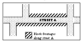
Block Frontage
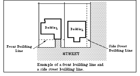
Building Lines
“C” Definitions
4
and any other elements or facilities owned and used by all members of a development such as a condominium or subdivision and designated in the master deed as common area.
A temporary cul-de-sac not complete at the time of final plat approval must be completed within 2 years after the approval of the final plat, pursuant to the terms and requirements of a performance bond.
shall mean the width of the intersection of the driveway pavement (including radii) with the public street pavement.
“D” Definitions
5
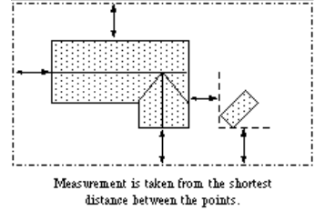
Closest Distances
A means of egress comprises the vertical and horizontal ways of travel and shall involve the intervening room space, doors, corridors, passageways, balconies, stairs, ramps, enclosures, lobbies, horizontal exits, courts, and yards.
“F” Definitions
6
“G” Definitions
“I” Definitions
“L” Definitions
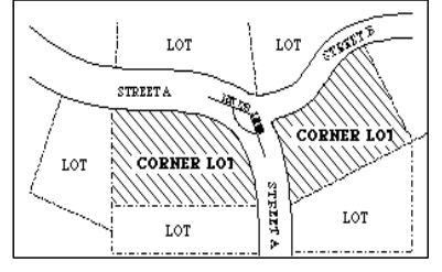
Corner Lots
See Figure L.1 for illustration.
8
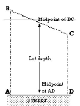
Dept of Lot
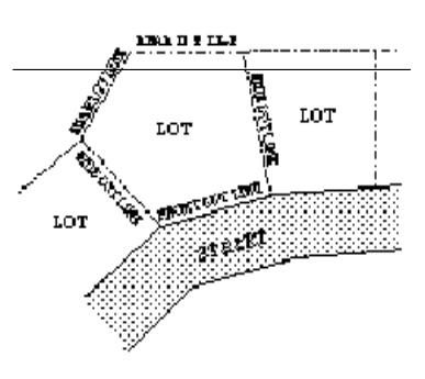
Lot lines on Irregular Lots Lot lines on Irregular Lots 9
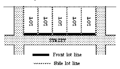
Front and Side Lot Line
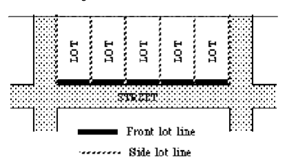
R e a r L o t L i n
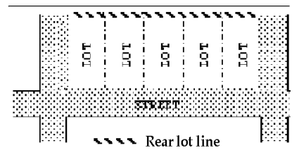
Width of Lot
See Figure L.7 for illustration.
“M” Definitions
“N” Definitions
“O” Definitions
“P” Definitions
11
Such a meeting is mandatory in some circumstances as provided by this Ordinance and in all other circumstances it is an option.
“R” Definitions
See Stream or Creek.
and carrying water to a release point on the other side.
“S” Definitions
or
Because of the nature of the travel served by the principal arterial system, almost all fully and partially controlled access facilities will be part of this functional system. In order to preserve the identification of controlled access facilities, the principal arterial system is stratified as follows:
14 1.Interstate Principal Arterial- those routes presently designated by the USDOT as part of the Interstate System.
2.Urban Freeway and Expressway – limited-access urban arterials not on the Interstate System 3.Urban Principal Arterial- uncontrolled or partial controlled access
Urban Minor Arterial Street- provide service to trips of moderate length within an urban area, and this system should distribute travel to geographic areas smaller than those identified with the higher system. Such facilities may carry local bus routes and provide intra-community continuity but ideally should not penetrate identifiable neighborhoods. This system should include urban connections to rural collector roads where such connections have not been classified as urban principal arterials.
The spacing of minor arterial streets may vary from 1/8 - 1/2 mile in the central business district to 2 - 3 miles in the suburban fringes, but should normally be not more than 1 mile in fully developed areas.
Urban Collector Street- collects traffic from local streets in residential neighborhoods and channels it into the arterial system. In the central business district, and in other areas of like development and traffic density, the collector system may include the street grid which forms a logical entity for traffic circulation.
15
“T” Definitions
16
“U” Definitions
“V” Definitions
“W” Definitions
17 “Z” Definitions
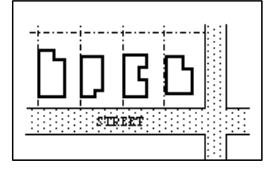
Zero Lot Lines
Jurisdiction and Applicability.
Land Subdivision, Scope of Term.
Land subdivision includes all divisions of a tract or parcel of land into two or more lots, building sites, or other division for the purpose, whether immediate or future, of sale, legacy, or building development, and includes all division of land involving a new street or a change in existing streets, and includes resubdivision and, where appropriate to the context, relates to the process of subdividing or to the land or area subdivided.
There shall be two subdivision types within the City of Newnan including:
19
Compliance With Regulations Prerequisite to Approval of Subdivision.
No subdivision of land within the City that fails to meet the requirements of these regulations shall be approved by the Planning Commission.
Transfer, Sale of Land in Unapproved Subdivision.
The transfer of, sale of, agreement to sell, or negotiation to sell land by reference to or exhibition of, or other use of a plat of a subdivision that has not been given final approval under the terms of these regulations and recorded in the Office of the Clerk of the Superior Court of Coweta County shall be a misdemeanor, punishable as provided by law;
and the description by metes and bounds in the instrument of transfer or other document shall not exempt the transaction from such penalties.
Construction Prohibited.
Effect of Conflict of Provisions.
Insofar as the provisions of these regulations are inconsistent with the provisions of any other ordinance, the provisions of these regulations shall be controlling. The requirements of, restrictions imposed and powers conferred by these regulations shall be in addition and supplemental to the requirements of, restrictions imposed, and powers conferred by other ordinances.
Variances.
Applications for variances from the provisions of these regulations shall be heard by the Board of Zoning Appeals under the terms of the City of Newnan Zoning Ordinance.
Plats.
20
For a major subdivision, following the preapplication review, the subdivider or his agent shall submit to the City of Newnan:
sidewalks, crosswalks and ramps.
Furthermore, street names within the same development cannot be replicated by switching the street type.
All subdivision and street names must receive approval from the Coweta County E-911 agency.
23
Said certification shall be based on the level of testing specified by the City.
24
25
It is hereby certified that this plat is true and correct and was prepared from an actual survey of the property by me or under my supervision; that all monuments shown hereon actually exist and their location, size, type and material are correctly shown; and that all requirements of the land subdivision regulations of the City of Newnan, Georgia have been fully complied with.
By Reg. Georgia Land Surveyor No.
State of Georgia, County of Coweta I, being the owner of the land shown on this plat, hereby certify that: all state, city and county taxes or other assessments now due on this land have been paid; all streets, drainage ways and easements shown hereon are dedicated to the use of the public and enforcement by public safety officials forever; and, that I will be responsible for the maintenance and repair of all infrastructure associated with this development until expiration of the maintenance period.
Property Owner Date
The City of Newnan hereby accepts all street right-of-ways and the improvements therein and any catch basins, junction boxes, storm drainage pipe easements, or other structures or areas outside of said street right-of-way (excluding ditches and other open drainage ways) which are specifically indicated on this plat as being dedicated to the public; however, this certification does not obligate the City to maintain the above stated infrastructure until expiration of the maintenance period.
City Manager Date
Pursuant to the land subdivision regulations of the City of Newnan, Georgia, all requirements of approval having been fulfilled, this final plat was given final approval on , 20 .
26 Director of the Planning Department Date
The developer shall also provide a maintenance bond in the amount of 50% of the actual cost of construction to guarantee the quality of materials and workmanship for infrastructure that is complete at the time of the final plat. The bond shall be in effect for a minimum of two years after the approval of the final plat and shall continue to be in effect until 80% of the development/subdivision is completed (whichever is greatest.)
Any improvements, amenity areas, recreation areas, etc. must be completed within two (2) years after approval of the final plat. The developer shall also provide a performance bond in the amount of 125% of the actual cost of construction to guarantee completion of recreation areas, amenity areas, and other private improvements shown at the time of final plat approval. The bond shall be in effect for two years after the approval of the final plat and shall continue to be in effect until 50% of the development/subdivision is completed (whichever is greatest.)
All “as-built” drawings shall be submitted in both hard copy and digital format and be on the state plane coordinate system, USA, GA, NAD 83, West. The digital copy shall be in a format acceptable to the City of Newnan.
Minimum Requirements and Design Standards.
Floodplains – In accordance with the City’s Floodplain Ordinance, an engineering study/plan must be submitted for all lands within any area of special flood hazard established in the City of Newnan’s Floodplain Ordinance subsection 10-184. This plan shall be in accordance with criteria established in this section. This plan must be submitted with the stamp and signature of a professional engineer (PE) licensed in the state of Georgia, who will verify that all designs are consistent with requirements of subsection 10-184.
Standard Specifications, Generally - Streets shall be classified into a street hierarchy system and street design standards, design criteria and level of service shall be based on the functional classification of the facility. Traffic volumes, existing and projected, shall serve to further refine the design criteria for each functional classification.
All streets, public and private, shall be designed and constructed to the standards of the City of Newnan, as set forth by Ordinance of the City of Newnan, together with (and according to) the latest official set of Standard Details, as adopted and maintained on file for consultation and distribution by the Public Works Department of the City of Newnan.
Unless otherwise specially set forth in this code or the Standard and Details, all materials, methods of construction, and workmanship for the work covered in reference to street construction and storm drainage construction shall conform to the latest standard specifications of the Georgia Department of Transportation.
For design criteria not specifically addressed by Ordinance of the City of Newnan or the latest standard specifications of the Georgia Department of Transportation, reference shall be made to the latest edition of A Policy on Geometric Design of Highways and Streets, as published by the American Association of State Highway and Transportation Officials (AASHTO).
Streets serving residential subdivisions shall be arranged and designed incorporating traffic management and traffic calming methods in order to reduce traffic speeds, vehicle noise, visual impact and through volumes in residential neighborhoods.
Requirements for Existing Streets— When property proposed for development is to be accessed from an existing City street, the extension of existing street shall be continued at the same or greater width, but in no case less than the width required for the designated street classification of the existing street, and shall meet the minimum standards for the designated street classification of the existing street.
Existing Streets Widened 29 When property proposed for development fronts on an existing City street, the developer shall cause to be constructed, at the developer’s expense, improvements, including pavement, curb and gutter, drainage and traffic control devices, to the existing street, along the entire property frontage, from the centerline of the existing street along the side of the street upon which the property abuts. Such improvements shall meet minimum standards for the designated street classification of the existing street.
Existing Substandard Streets For development having access to a substandard street and said substandard street provides the primary means of access to the development, the substandard street shall be fully upgraded and the full width of the roadway along the entire property frontage, continuing to the nearest standard paved road along the route of primary access, shall be paved with asphaltic concrete.
For development having access to a substandard street and said substandard street provides other than primary means of access to the development, the substandard sheet shall be fully upgraded only along the entire property frontage and shall be paved on the opposite side of the road from the development, with asphaltic concrete, for a width not less than twelve (12) feet from the centerline of the street.
Streets that are obviously in alignment with streets already existing and named shall be given the name of the existing street. Street name signs shall be installed at all intersections. Lettering on ground- mounted street name signs shall be six (6) inch upper-case letters. Lettering on ground-mounted street name signs for multi-lane streets with speed limits greater than forty (40) mph shall be eight (8) inch upper-case letters. Supplementary lettering to indicate the type of street may be in smaller lettering three (3) inches high. Street name signs shall have a white legend on a green background, unless approved otherwise by the City Engineer.
Street name signs shall be posted on the same post with, and above, a stop or yield sign, as appropriate for the intersection, unless approved otherwise by the City Engineer.
Roundabouts shall be designed and constructed with a flare or widening of the approaches to allow for proper operation, and shall accommodate the design vehicle appropriate for the streets intersecting at the roundabout. When crosswalk markings are used within a roundabout, those markings shall be located a minimum of twenty five (25) feet upstream from the yield point of entry.
31
Because of the nature of the travel served by the principal arterial system, almost all fully and partially controlled access facilities will be part of this functional system.
In order to preserve the identification of controlled access facilities, the principal arterial system is stratified as follows:
Urban Minor Arterial Street- provide service to trips of moderate length within an urban area, and this system should distribute travel to geographic areas smaller than those identified with the higher system. Such facilities may carry local bus routes and provide intra-community continuity but ideally should not penetrate identifiable neighborhoods. This system should include urban connections to rural collector roads where such connections have not been classified as urban principal arterials.
The spacing of minor arterial streets may vary from 1/8 - 1/2 mile in the central business district to 2 - 3 miles in the suburban fringes, but should normally be not more than 1 mile in fully developed areas.
Urban Collector Street- collects traffic from local streets in residential neighborhoods and channels it into the arterial system. In the central business district, and in other areas of like development and traffic density, thecollector system may include the street grid which forms a logical entity for traffic circulation.
Minimum Street Right-Street Classification of-WaRyight-of-W ay (feet)
Principal Arterial 100 Minor Arterial 80 Principal Collector 80 Minor Collector 60 Local Residential 50 Local Residential Cul-de-Sac 50 Radius Local Non-Residential 60 Local Non-Residential Cul-de-sac 60 Radius For any street proposed with a median, the minimum right-of-way increases in proportion to the median width. s a
For single lane, one-way local streets, in order to provide a ten (10) foot lane for moving traffic and eight (8) feet for parking, the minimum roadway width shall be twenty-two (22) feet, back of curb to back of curb.
Cross Slope: The cross slope for lanes on a normal crown section shall be one quarter (1/4) inch per foot sloped towards the outer edge of pavement. The cross slope shall be adjusted where superelevation requirements are incorporated into 33 the design for transitions from/to normal crown at each end of horizontal curves, in accordance with the design standards of the Georgia Department of Transportation.
Street Grades, Horizontal Alignment, Tangent Sections, and Vertical Alignment –Design criteria for street grades, horizontal alignment, tangent sections, and vertical alignment shall be in accordance with the design standards of the Georgia Department of Transportation and for design criteria not specifically addressed by Ordinance of the City of Newnan or the latest standard specifications of the Georgia Department of Transportation, reference shall be made to the latest edition of A Policy on Geometric Design of Highways and Streets, as published by the American Association of State Highway and Transportation Officials (AASHTO).
Medians which may provide a refuge area for pedestrian crossings shall be convex or raised medians and shall incorporate standard curb and gutter. The pedestrian crossing through the median shall meet all current requirements of the Georgia Department of Transportation for safety and accessibility.
34
This requirement is subject to a variance where the topography or other physical limiting factor may be present.
Any flag lot existing at the time of adoption of this Ordinance shall not be further subdivided, unless the new lots created conform to City Ordinance.
2). Lot Size—Lot size for residential and for non-residential lots shall be as required by the Zoning Ordinance.
3). Lot Lines—All lot lines shall be perpendicular or radial to street lines.
Dimensions of corner lots shall be large enough to allow for the additional side yard width adjoining the street (unless a variation from this rule will give a better street or lot plan).
4). Lots Abutting Public Streets—Each lot shall abut upon a dedicated public street unless otherwise provided by these regulations.
5). Lot Depth –- Excessive depth in relation to width is to be avoided, with a ratio of 3:1 considered as the desirable maximum and a ratio of 5:1 being the definite maximum. Lots shall only exceed the desirable maximum of 3:1 when the area used to create the additional depth would not otherwise be better suited as common open space and would not create a conflicting situation with adjoining land uses; or topographical conditions on the lot warrant additional depth for building purposes. (10/24/2000)
36
Street Light         High Pressure Sodium  Fixture

Spacing              Bulb Wattage          Height

150’-180’            100 Watt              16’

200’-250’            175 Watt              16’

300’-400’            400 Watt              25’
Street lights shall be installed and operational prior to street acceptance by the City Council or the developer must provide proof of payment from the utility company or record covering installation costs. Upon street acceptance by the City Council, the operation of street lights shall be paid for by the City.
37
The maintenance of all traffic control devices on private streets shall be included in the maintenance agreement.
38
39
Driveway Access.
40
41
Where a median with a left-turn lane will be necessary to serve a particular development, an additional sixteen (16) feet of lane width shall be provided by the property owner.
An acceleration lane shall be required where (a) the owner's property extends to an intersection with a collector or arterial street within 150 feet of the driveway in the direction of traffic flow, or (b) the required taper will merge with the taper of an existing deceleration lane or is within twenty (20) feet of merging.
43
A mixture of the above uses will require a case-by-case determination of traffic generation by the City Engineer. Acceleration/deceleration lanes shall be required when sufficient additional development occurs on property previously exempted from the requirement.
44
Inadequate sight distance.
and establish such additional standards (in writing or in drawings) as are necessary to clarify these regulations and assure traffic safety and protection of traffic capacity on the public streets.
45
Standard Development Details.
The City of Newnan will maintain on file for consultation and distribution a series of standard drawings and details illustrating standard design and details of construction of streets and roadways, including drainage facilities for land development.
The standard drawings and details illustrate minimum acceptable standards for design and construction associated with land development activities for streets, drainage facilities and other infrastructure improvements. These minimum standards shall not supersede more restrictive prudent design requirements or good engineering practice as applied to specific situations.
Unless otherwise specially set forth in this code or the Design and Construction Standards and Details, all the materials, methods of construction, and workmanship for the work covered in reference to street construction and storm drainage construction shall conform to the latest standard specifications of the Georgia Department of Transportation.
For design criteria not specifically addressed by Ordinance of the City of Newnan or the latest standard specifications of the Georgia Department of Transportation, reference shall be made to the latest edition of the American Association of State Highway and Transportation Officials (AASHTO) “A Policy on Geometric Design of Highways and Streets”.
46