LandCode
LawrencevilleZoning Ordinance

Article 1 — Districts

current as of 2026-04-27verified current · checked 2026-08-24Officialofficial source21 sections · full chapter
§ article-1-preamble

Article 1 front matter — Interpretation; Districts

Interpretation The following graphics depict the interpretation of lot development standards. The official definitions for these terms can be found in Article 10, Definitions, and should be used for any legal determinations.

Lot Area Dimensions Ⓐ Lot Width Ⓑ Lot Depth Principal Structure Building Setbacks Ⓒ Front Yard Area Ⓓ Side Yard Area Ⓔ Rear Yard Area Accessory Structure Building Setbacks Ⓕ Side Yard Area Ⓖ Rear Yard Area Lot Coverage Ⓗ Buildable Area Maximum Building Height Ⓘ Principal Building Ⓙ Story Ⓚ Accessory Building Districts For uses allowed in each district, please see Section 103.2 Use Table

§ 102.1

AR Agricultural Residential District

A.Purpose The Agricultural Residential district provides an environment where limited agricultural endeavors can operate compatibly with a greater density of population than is normally found in farming areas.
B.Lot Development Standards
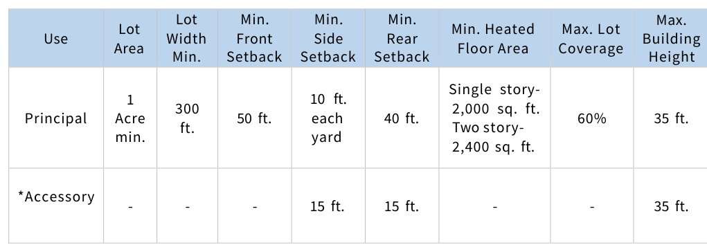
Dimensional standards
Table shown as printed · verify at source (p. 2)

Barns and other agricultural structures are permitted at any size for active agriculture activity.

*Accessory structures are prohibited in the front yards.
C.Protective Covenant The development shall have a mandatory community association(s) to provide maintenance for all common areas (including the maintenance of landscaping within internal rights-of-way and immediately adjacent external rights-of-way) and enforce reasonable and customary property maintenance standards through covenants on all residences within the community. The covenants, conditions, and restrictions that will be recorded with the City prior to the issuance of the first building permit. The covenants will run for 20 years and automatically renew every 20 years unless 51% of the persons owning lots in the subdivision vote to terminate the covenants as governed by O.C.G.A. 44-5-60. Subject to applicable City, local, and federal rules, laws, regulations, and rulings of courts having competent jurisdiction over the subject property, said covenants shall include a restriction that no more than 10% of the single-family units (with an additional 5% hardship) may be leased to third parties by individual owners.
§ 102.2

RS-180 Single-Family Residential District
A.Purpose The RS-180 Single-Family Residential District is intended for single-family homes and designed to stabilize and protect the residential characteristics of the district.
B.Lot Development Standards Use
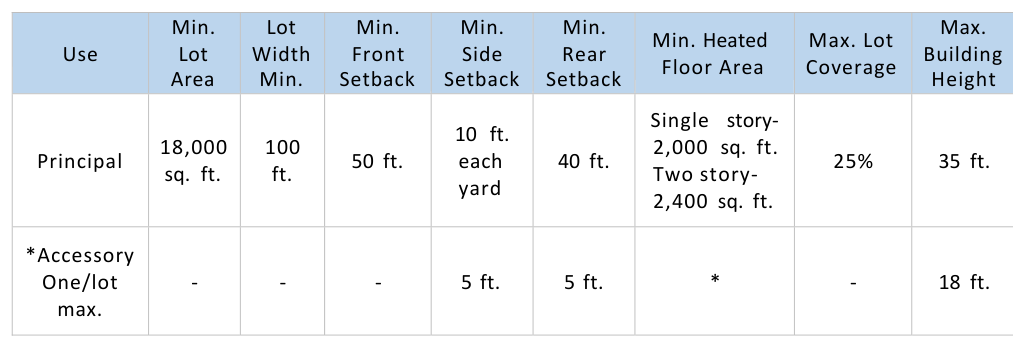
Dimensional standards
Table shown as printed · verify at source (p. 4)
*Maximum of 400 square feet. Accessory structures are prohibited in front yards. Utilities shall be underground.
C.Mandatory Homeowners Association.

As part of the planning process for the development of a subdivision, the developer shall propose at the time of the request for development a Homeowners Association to be attached to the development of the property. The Homeowners Association shall be recorded in the deed records of the Superior Court of Gwinnett County either as written restrictive covenants or on the plat for development of the subdivision.

D.Protective Covenant The development shall have a mandatory community association(s) to provide maintenance for all common areas (including the maintenance of landscaping within internal rights-of-way and immediately adjacent external rights-of-way) and enforce reasonable and customary property maintenance standards through covenants on all residences within the community. The covenants, conditions, and restrictions that will be recorded with the City prior to the issuance of the first building permit. The covenants will run for 20 years and automatically renew every 20 years unless 51% of the persons owning lots in the subdivision vote to terminate the covenants as governed by O.C.G.A. 44-5-60. Subject to applicable City, local, and federal rules, laws, regulations, and rulings of courts having competent jurisdiction over the subject property, said covenants shall include a restriction that no more than 10% of the single-family units (with an additional 5% hardship) may be leased to third parties by individual owners.
§ 102.3

RS-150 Single-Family Residential District
A.Purpose The RS-150 Single-Family Residential District is intended for single-family homes and designed to stabilize and protect the residential characteristics of the district.
B.Lot Development Standards
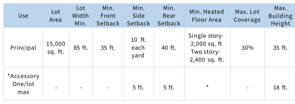
Dimensional standards
Table shown as printed · verify at source (p. 6)

*400 square feet maximum. Accessory structures are prohibited in front yards. Utilities shall be underground.

C.Mandatory Homeowners Association.

As part of the planning process for the development of a subdivision, the developer shall propose at the time of the request for development a Homeowners Association to be attached to the development of the property. The Homeowners Association shall be recorded in the deed records of the Superior Court of Gwinnett County either as written restrictive covenants or on the plat for development of the subdivision.

D.Protective Covenant The development shall have a mandatory community association(s) to provide maintenance for all common areas (including the maintenance of landscaping within internal rights-of-way and immediately adjacent external rights-of-way) and enforce reasonable and customary property maintenance standards through covenants on all residences within the community. The covenants, conditions, and restrictions that will be recorded with the City prior to the issuance of the first building permit. The covenants will run for 20 years and automatically renew every 20 years unless 51% of the persons owning lots in the subdivision vote to terminate the covenants as governed by O.C.G.A. 44-5-60. Subject to applicable City, local, and federal rules, laws, regulations, and rulings of courts having competent jurisdiction over the subject property, said covenants shall include a restriction that no more than 10% of the single-family units (with an additional 5% hardship) may be leased to third parties by individual owners.
§ 102.4

RS-60 Single-Family Residential District
A.Purpose This zoning district is intended to allow the construction of Single-Family developments on very small lots.
B.Lot Development Standards Development size requirement: 10 acres minimum.
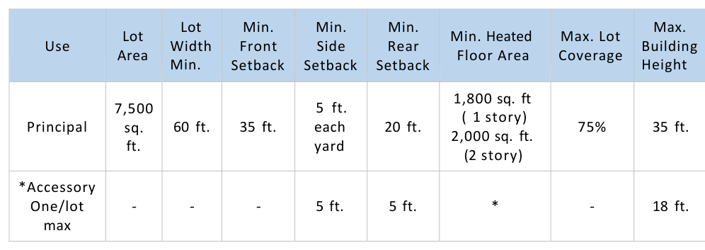
Dimensional standards
Table shown as printed · verify at source (p. 8)
*Maximum 400 square feet. Accessory structures are prohibited in the front yard.
C.Miscellaneous Provisions This zoning classification will contain provisions for green space areas for common benefit of the community to be maintained by a homeowner’s association.

The zoning district shall be considered through individual rezoning applications where water supply and sewage facilities are available or can be obtained and where there is convenient access to collector streets, major thoroughfares, or state and interstate highways. A complete detailed site plan shall be submitted with each application showing, among other things, open space and recreational amenities. Such application shall also include additional information, such as architectural renderings and restrictive covenant controls to be used by the Planning Commission and the City of Lawrenceville to determine if a proposed project is in the interest of the health, safety, and welfare of the community for which it is proposed.

D.Mandatory Homeowners Association, Minimum Restrictive Covenant Requirements:

As part of the planning process for the development of a subdivision, the developer shall propose at the time of the request for development a Homeowners Association to be attached to the development of the property. The Homeowners Association shall be recorded in the deed records of the Superior Court of Gwinnett County either as written restrictive covenants or on the plat for development of the subdivision.

E.Protective Covenant The development shall have a mandatory community association(s) to provide maintenance for all common areas (including the maintenance of landscaping within internal rights-of-way and immediately adjacent external rights-of-way) and enforce reasonable and customary property maintenance standards through covenants on all residences within the community. The covenants, conditions, and restrictions that will be recorded with the City prior to the issuance of the first building permit. The covenants will run for 20 years and automatically renew every 20 years unless 51% of the persons owning lots in the subdivision vote to terminate the covenants as governed by O.C.G.A. 44-5-60. Subject to applicable City, local, and federal rules, laws, regulations, and rulings of courts having competent jurisdiction over the subject property, said covenants shall include a restriction that no more than 10% of the single-family units (with an additional 5% hardship) may be leased to third parties by individual owners.
F.Green Space Every RS-60 single-family residential development shall be required to construct an area of public green space within the confines of the development. The minimum green space required shall be 15% of the total acreage of the project excluding 50% of the 100-year flood plain and wetland areas. . The green space shall be designed and constructed pursuant to the following regulations:
1.Contiguous green space is encouraged. Green space that is across a right of way shall not be counted towards the required amount.
2.All green space must have at least thirty (30) feet of width to be considered in the calculations.
3.The green space must be commonly owned by all of the residents of the subdivision. The developer shall establish a homeowner’s association for purposes of transferring title to the green space at the time development begins on the subdivision.
4.The green space shall be constructed as part of the first phase of development.
5.The green space shall be passive except for walking trails which may be constructed therein. Active recreation areas, including swimming pools, tennis courts, basketball courts, clubhouses, and other recreational amenities may not be constructed in the green space.
6.All green space shall be undisturbed, until after the final plat has been approved and recorded.
G.Utility Restrictions All utilities shall be located underground.
§ 102.5

RS – 50 INF – One-Family Infill Residential District

A.Purpose.

This RS-50 INF zoning district is intended for the infill development of high- density detached one-family dwellings and dwelling units within the boundaries of the City of Lawrenceville Infill District Map 1 ..

1.The Lawrenceville Infill District Map is adopted in Section 103.3 and incorporated herein by reference.
B.One-Family Dwelling and Dwelling Unit Standards.

A one-family dwelling constructed of one detached dwelling unit, and only one detached dwelling unit, in which a detached dwelling unit extends from foundation to roof and with a yard of public way on not less than four sides. A one-family dwelling shall have at least one (1) story above the centerline grade of an adjacent public right-of-way, or private street easement.

C.Site Development Standards.

Property in the RS-50 INF zoning classification shall be developed in accordance with the applicable site-related provisions contained in this Article, and the City of Lawrenceville Subdivision Regulations and Development Regulations.

1.Density.

Gross density in an RS-50 INF zoning classification shall not exceed 12 Units Per Acre (UPA). Density shall be calculated as defined in Article 10 Definitions, Density - Gross, and Density - Net.

2.Off-Street Parking.

Off-street parking for Passenger Car, SUV, Truck, or Van shall be provided and designed in accordance with the Zoning Ordinance, Article 5 Parking. Off-street parking calculations shall be based on use and/or occupancy.

a.Off-Street Parking may be provided utilizing Option 1. or Option 2.:

Option 1. Off-Street Attached or Detached Garage.

Off-Street garages shall be constructed with a two-car garage.

Off-street garages shall be located internal to the development and obstructed from the view of an adjacent public right-of-way.

Option 2. Off-Street Parking Lot.

Off-Street parking lots shall be constructed providing a minimum of two and one-half (2 ½) parking spaces per dwelling unit. The design and location of an Off-Street Parking Lot shall be subject to the review and approval of the City Council.

Off-street parking lots shall be located internal to the development and obstructed from the view of an adjacent public right-of-way.

b.Off-Site Parking.

Where a property is unable to meet the minimum requirements set forth in Subsection C.2.a. Option 1. or Option 2., the applicant for such use must provide to the Department of Planning and Development proof of adequate off-site parking by agreement with other property owners or will be required to enter into an agreement with the City through entry into the Downtown Parking Credit program.

The minimum number of off-street parking spaces shall not be altered by a Variance.

3.Sewer Capacity.

Sewer Capacity Certification Request shall require the review and approval of the Gwinnett County Department of Water Resources.

4.Road Classification.

RS-50 INF one-family lots shall not have direct access to an external classified Freeway/Expressway, Arterial (Principal, Major, Minor), Collector (Major, Minor).
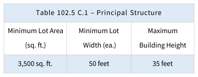
D.Lot Dimensional Standards.
Table 102.5 C.1 – Principal Structure
Table shown as printed · verify at source (p. 12)

Table 102.5 C.2 – Principal Structure 2 . , 3 . , 4 . & 5 .

Minimum Front Yard Setback Minimum Rear Yard Setback Minimum Side Yard Setback Minimum Heated Floor Area Minimum Heated Floor Area 10 feet 10 feet 5 feet 1,600 sq. ft.

(1 story)

1,800 sq. ft.

(2 story)

2.Minimum Front, Rear and Side Yard Setbacks adjacent to a classified internal Local Street, Private Access Utility Easement or Private Parking Lot shall be as indicated in Table 102.5.C.2.
3.Minimum Front, Rear and Side Yard Setbacks shall be a minimum of fifteen-feet (15 ft.)

adjacent to a classified external Local Street.

4.Minimum Front, Rear and Side Yard Setbacks shall be a minimum of twenty-feet (20 ft.)

adjacent to a classified Freeway/Expressway, Arterial (Principal, Major, Minor), Collector (Major, Minor).

5.Minimum Dwelling Separation – Multiple detached one-family dwellings on a singular lot shall be subject to the rules and regulations of the International Residential Code, Part III, Section R302 Fire-Resistant Construction.

Table 102.5 C.3 – Accessory Structure Maximum Square Footage Front Yard Setback Side Yard Setback Rear Yard Setback Building Height 500 sq. ft. Prohibited 5 feet 10 feet 18 feet

E.Miscellaneous Provisions.

This zoning classification will contain provisions for common area for the benefit of the community to be maintained by a homeowner’s association. The zoning district shall be considered through individual rezoning applications where water supply and sewage facilities are available or can be obtained and where there is convenient access to collector streets, major thoroughfares, or state and interstate highways. A complete detailed site plan shall be submitted with each application showing, among other things, open space and recreational amenities. Such application shall also include additional information, such as architectural renderings and restrictive covenant controls to be used by the Planning Commission and the City of Lawrenceville to determine if a proposed project is in the interest of the health, safety, and welfare of the community for which it is proposed.

F.Mandatory Homeowners Association, Minimum Restrictive Covenant Requirements.

As part of the planning process for the development of a subdivision, the developer shall propose at the time of the request for development a Homeowners Association to be attached to the development of the property. The Homeowners Association shall be recorded in the deed records of the Superior Court of Gwinnett County either as written restrictive covenants or on the plat for development of the subdivision.

G.Protective Covenant.

The development shall have a mandatory community association(s) to provide maintenance for all common areas (including the maintenance of landscaping within internal rights-of-way and immediately adjacent external rights-of-way) and enforce reasonable and customary property maintenance standards through covenants on all residences within the community. The covenants, conditions, and restrictions that will be recorded with the City prior to the issuance of the first building permit. The covenants will run for 20 years and automatically renew every 20 years unless 51% of the persons owning lots in the subdivision vote to terminate the covenants as governed by O.C.G.A. 44-5-60. Subject to applicable City, local, and federal rules, laws, regulations, and rulings of courts having competent jurisdiction over the subject property, said covenants shall include a restriction that no more than 10% of the one-family units (with an additional 5% hardship) may be leased to third parties by individual owners.

H.Minimum Common Area Standards
1.All one-family developments, including mixed-use proposals with a one- family component, consisting of five (5) or more individual buildable lots (as per Subdivision Regulations, Sec. 3. Minor Subdivision.) shall require a Minimum Common Area comprising ten (10%) percent of the total project acreage.

Compliance with this requirement is mandatory and subject to the review and approval of the Director of the Planning and Development Department.

2.Common areas shall not include any land area within undevelopable land designated or identified as a federal, state, regional, local protected area, bluff, floodplain, stream buffer or wetlands.
3.Common areas shall be designated on a recorded plat as a permanent recreation easement for recreational purposes, such as but not limited to parks, playgrounds, and other similar recreation uses.
4.Common Areas shall consist of one (1) recreational feature, such as a public gathering area (e.g., green, park, plaza, square or similar approved recreational area).
5.Common Areas shall be accessible to the residents.
I.Utilities All existing and proposed utilities located along streets in the RS-50 INF District, except for substations and major electric transmission lines located on separate easements, are required to be placed underground or relocated to the rear of the property so that they will be less visible from the streets.
§ 102.6

RS-TH INF – Townhouse-Family Infill Residential District

A.Purpose.

This RS-TH INF zoning district is intended for the infill development of medium-density townhouse-family dwellings and dwelling units within the boundaries of the City of Lawrenceville Infill District Map 6..

6.The Lawrenceville Infill District Map is adopted in Section 103. 3 and incorporated herein by reference.
B.Townhouse-Family Dwelling Unit Standards.
1.Townhouse-Family Dwelling and Dwelling Units.

A townhouse-family dwelling shall be constructed in a minimum of three (3) attached dwelling units, but not more than a maximum of eight (8) attached dwelling units in which each dwelling unit extends from foundation to roof.

Each one-family attached townhouse dwelling unit is separated from any other dwelling unit by one or more vertical common fire-resistance-rated walls. A townhouse shall have a minimum of two (2) stories above the centerline grade of an adjacent public right-of-way.

C.Site Development Standards.
1.Density.

Gross density in an RS-TH INF zoning classification shall not exceed 16 Units Per Acre (UPA). Density shall be calculated as defined in Article 10 Definitions, Density – Gross, and Density – Net.

2.Off-Street Parking.

Off-street parking for Passenger Car, SUV, Truck, or Van shall be provided and designed in accordance with the Zoning Ordinance, Article 5 Parking. Off-street parking calculations shall be based on use and/or occupancy.

a.Off-Street Parking may be provided utilizing Option 1. or Option 2.:

Option 1. Off-Street Attached or Detached Garage.

Off-Street garages shall be constructed with a rear-entry two-car garage.

Off-street garages shall be located internal to the development and obstructed from the view of an adjacent public right-of-way.

Option 2. Off-Street Parking Lot.

Off-Street parking lots shall be constructed providing a minimum of two and one-half (2 ½) parking spaces per dwelling unit. The design and location of an Off-Street Parking Lot shall be subject to the approval of the City Council.

Off-street parking lots shall be located internal to the development and obstructed from the view of an adjacent public right-of-way.

b.Off-Site Parking.

Where a property is unable to meet the minimum requirements set forth in Subsection C.2.a. Option 1. or Option 2., the applicant for such use must provide to the Department of Planning and Development proof of adequate off-site parking by agreement with other property owners or will be required to enter into an agreement with the City through entry into the Downtown Parking Credit program.

The minimum number of off-street parking spaces shall not be altered by a Variance.

3.Sewer Capacity.

Sewer Capacity Certification Request shall require the review and approval of the Gwinnett County Department of Water Resources.

4.Road Classification.

RS-TH INF townhouse-family lots shall not have direct access to an external classified Freeway/Expressway, Arterial (Principal, Major, Minor), Collector (Major, Minor).

See figures for examples:

Ex. No. 1 - Rear Entry Townhouse Dwelling Units

D.Lot Dimensional Standards.

Property in the RS-TH INF District shall be developed in accordance with the applicable provisions contained in the City of Lawrenceville Development Regulations and Subdivision Regulations, and the following additional standards:
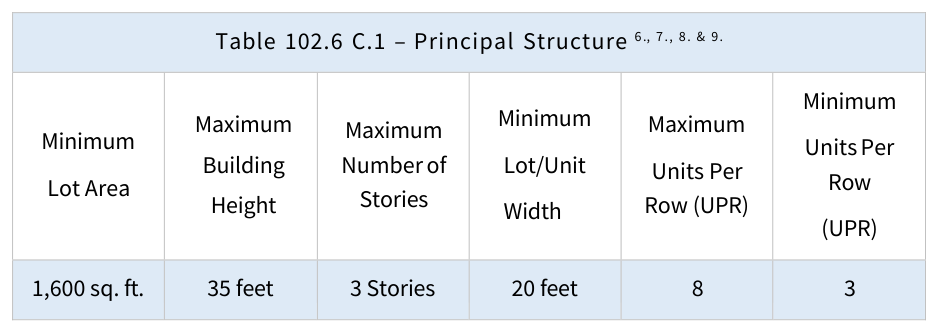
Table 102.6 C.1 – Principal Structure 6 ., 7 . , 8 . & 9 .
Table shown as printed · verify at source (p. 18)

Table 102.6 C.2 – Principal Structure Minimum Front Yard Setback Minimum Rear Yard Setback Minimum Side Yard Setback Minimum 9.

Dwelling Separation 10 feet 10 feet 0 feet Per IRC Section R302

6.Minimum Front, Rear and Side Yard Setbacks adjacent to a classified internal Local Street, Private Access Utility Easement or Private Parking Lot shall be as indicated in Table 102.6.C. 2.
7.Minimum Front, Rear and Side Yard Setbacks shall be a minimum of fifteen- feet (15 ft.) adjacent to a classified external Local Street.
8.Minimum Front, Rear and Side Yard Setbacks shall be a minimum of twenty-feet (20 ft.) adjacent to a classified Freeway/Expressway, Arterial (Principal, Major, Minor), Collector (Major, Minor).
9.Minimum Dwelling Separation – Multiple townhouse- family dwellings on a singular lot shall be subject to the rules and regulations of the International Residential Code, Part III, Section R302 Fire-Resistant Construction.

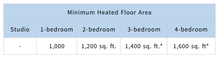
Table 102.6 C.3. - Minimum Heated Floor Area Studio 1-bedroom 2-bedroom 3-bedroom 4-bedroom

-1,000 sq. ft. 1,200 sq. ft. 1,400 sq. ft. 1,600 sq. ft.
1.RS-TH Townhouse Units – General.
a.Front façade(s) of townhouse dwelling units shall be parallel or radial to a Public Street (Public Right-of-Way).
b.Front façade(s) of townhouse dwelling units shall be staggered or offset to a minimum of two (2) feet providing architectural relief.
c.Rear elevations of each townhouse dwelling unit shall consist of porch measuring 18 feet in width and 10 feet in depth.
E.Miscellaneous Provisions.

This zoning classification will contain provisions for common area for the benefit of the community to be maintained by a homeowner’s association. The zoning district shall be considered through individual rezoning applications where water supply and sewage facilities are available or can be obtained and where there is convenient access to collector streets, major thoroughfares, or state and interstate highways. A complete detailed site plan shall be submitted with each application showing, among other things, open space and recreational amenities. Such application shall also include additional information, such as architectural renderings and restrictive covenant controls to be used by the Planning Commission and the City of Lawrenceville to determine if a proposed project is in the interest of the health, safety, and welfare of the community for which it is proposed.

F.Mandatory Homeowners Association, Minimum Restrictive Covenant Requirements.

As part of the planning process for the development of a subdivision, the developer shall propose at the time of the request for development a Homeowners Association to be attached to the development of the property. The Homeowners Association shall be recorded in the deed records of the Superior Court of Gwinnett County either as written restrictive covenants or on the plat for development of the subdivision.

G.Protective Covenant.

The development shall have a mandatory community association(s) to provide maintenance for all common areas (including the maintenance of landscaping within internal rights-of-way and immediately adjacent external rights-of-way) and enforce reasonable and customary property maintenance standards through covenants on all residences within the community. The covenants, conditions, and restrictions that will be recorded with the City prior to the issuance of the first building permit. The covenants will run for 20 years and automatically renew every 20 years unless 51% of the persons owning lots in the subdivision vote to terminate the covenants as governed by O.C.G.A. 44-5-60. Subject to applicable City, local, and federal rules, laws, regulations, and rulings of courts having competent jurisdiction over the subject property, said covenants shall include a restriction that no more than 10% of the single-family units (with an additional 5% hardship) may be leased to third parties by individual owners.

H.Minimum Common Area Standards.
1.All townhouse-family developments, including mixed-use proposals with a townhouse-family component, consisting of five (5) or more individual buildable lots (as per Subdivision Regulations, Sec. 3. Minor Subdivision.) shall require a Minimum Common Area comprising ten (10%) percent of the total project acreage. Compliance with this requirement is mandatory and subject to the review and approval of the Director of the Planning and Development Department.
2.Common areas shall not include any land area within undevelopable land designated or identified as a federal, state, regional, local protected area, bluff, floodplain, stream buffer or wetlands.
3.Common areas shall be designated on a recorded plat as a permanent recreation easement for recreational purposes, such as but not limited to parks, playgrounds, and other similar recreation uses.
4.Common Areas shall consist of one (1) recreational feature, such as a public gathering area (e.g., green, park, plaza, square or similar approved recreational area).
5.Common Areas shall be accessible to the residents.
I.Utilities.

All existing and proposed utilities located along streets in the RS-TH INF District, except for substations and major electric transmission lines located on separate easements, are required to be placed underground or relocated to the rear of the property so that they will be less visible from the streets.

§ 102.7

RM-8 Townhouse Residential District

A.Purpose The RM-8 Townhouse Residential District is designed to provide for townhome development that will be compatible when located near and among lower- and moderate-density types of developments.

Property in the RM-8 Townhouse Residential District shall be developed in accordance with the Minimum Lot Area requirement and the applicable site related provisions of the City of Lawrenceville Development Regulations.

B.Lot Development Standards Min.

Lot Area Unit Width Min.

External Min.

Front Setback External Min.

Side Setback External Min.

Rear Setback Min.

Heated Floor Area Impervious surface Max. Lot Coverage Max.

Building Height Min. % Com.

Area 5 acres 20 ft. 25 ft. 20 ft.* 20 ft.

See table below 40% 35 ft. 15%
40 feet if located on Major Arterial
This Minimum Lot Area shall not be reduced by a Variance. If property was zoned (RM- 12) General Residence, 3, 600 Sq. Ft. District at the time of adoption of the City of Lawrenceville Zoning Ordinance 2020 (ZON- ORD 2020- 9), on May 20, 2020, and property does not meet the Minimum Lot Area then the property owner may apply for a Variance.
Duplexes shall be prohibited.
Dimensional standards
Table shown as printed · verify at source (p. 22)

Minimum Dwelling Unit width Double-car garage 20 ft.

*Three-bedroom units shall be limited to 40% of the entire townhouse development.
*Four-bedroom units shall be limited to 10% of the entire townhouse development.
C.Mandatory Homeowners Association As part of the planning process for the development of a townhome subdivision, the developer shall propose at the time of the request for development a Homeowners Association to be attached to the development property. The Homeowners Association shall be recorded in the deed records of the Superior Court of Gwinnett County either as written restrictive covenants or on the plat for development of the subdivision.

The development shall have a mandatory community association(s) to provide maintenance for all common areas (including the maintenance of landscaping within internal rights-of-way and immediately adjacent external rights-of-way) and enforce reasonable and customary property maintenance standards through covenants on all residences within the community. The, and provide other services to be defined within the covenants, conditions, and restrictions that will be recorded with the City prior to the issuance of the first building permit. The covenants will run for 20 years and automatically renew every 20 years unless 51% of the persons owning lots in the subdivision vote to terminate the covenants as governed by O.C.G.A. 44-5-60. Subject to applicable City, local, and federal rules, laws, regulations, and rulings of courts having competent jurisdiction over the subject property, said covenants shall include a restriction that no more than 10% of the single-family units (with an additional 5% hardship) may be leased to third parties by individual owners.

Restrictive Covenant shall include the following:

Development amenities shall include a resort style pool, cabana, fitness center, and community room for residents. Community room shall be sized large enough for activities such as student after school programs, etc. Common area(s)/Park(s) shall be programed with amenities to maximize use such as benches, tables, grills, etc.

D.Architectural Standards Subject to review and approval by the Director of Planning and Development.
1.Each building shall consist of a minimum of two alternating roof types, specifically, open gable, boxed gable, dormer, hip, or flat roof lines.
2.Front, side, and rear facades shall be finished with primarily brick or stone on each elevation.
3.Elevations shall be staggered with alternating exterior treatments such as porches, balconies, awnings, chimney, stoops, decks, patios, and terraces.
4.Provide a unique architectural entrance with door surround.
5.Incorporate changes in building material texture, and color.
6.Provide elements such as shutters and roof eave brackets.
7.Refer to Article 6, Architectural and Design Standards, for types of materials allowed in the district.
See figures for examples:

Rear Entry Front Entry

E.Development Standards:

The following minimum requirements shall be applied to the property:

1.All vehicles shall be parked on a subdivision lot on an approved hard surface.
2.Internal yard requirements: A 20-foot grassed or landscaped strip shall be provided between all buildings (facades/elevations) and interior private drives.
3.A minimum of three and a maximum of eight units shall be allowed in each row of townhouses.
4.Private Drive shall be installed with the following dimensions:
a.Street width shall be 24 feet. Two-foot curb and gutter required (dimensions are back to back of curbs).
b.A 5-foot sidewalk is required and shall be 2 feet off the back of the curb.
5.All utilities shall be underground and shall be located within the required right-of-way.
6.All townhouses must be rear entry; driveways shall have no access to exterior streets.
7.Rear entry units shall abide by the following rules and regulations:
a.Rear entry units garages shall not be converted into heated interior space without being replaced with another garage within the building of the property subject to the terms of this Ordinance.
b.Driveway must provide two external parking spaces (9 ft. x 20 ft. each)
c.The rear elevation of Rear Entry Units shall be setback 27 feet from the required 24-foot Private Drive.
8.Front entry units shall require the approval of an associated Special Use Permit.

If approved, shall abide by the following rules and regulations:

a.Front entry units garages shall not be converted into heated interior space without being replaced with another garage within the building of the property subject to the terms of this Ordinance.
b.The front façade of Front Entry Units shall be setback 27 feet from required 24-foot Private Drive.
c.Driveway must provide two external parking spaces (9 ft. x 20 ft. each).
9.Each townhome residence shall have a two-car garage as a minimum requirement.
10.No plumbing or heating vents shall be placed on the front side roof of any structure in this district.
11.Building fronts shall be staggered to provide architectural relief.
12.Sidewalks on both sides of all streets including cul-de-sacs shall be required as set forth in the subdivision regulations of the City of Lawrenceville.
13.The term “pavement width of streets” as used in this Ordinance shall be defined as from the back of curb to back of curb.
14.No driveway shall have access to exterior streets.
15.Centralized mail kiosk shall have a minimum three-car stacking lane for every 100 units served.
16.Dumpsters and recycle bins shall be screened from all units and not visible from right-of-way.
F.Utility Restrictions
1.All utilities shall be located underground.
2.All utilities meters shall be located along a side or rear elevation.
G.Green/Common Space:
1.Every development shall be required to construct an area of public green space within the confines of the development.
2.At least 15% of the net project acreage (total acreage of the project excluding 50% of the 100-year floodplain and wetland areas) shall be designated on a recorded plat as a permanent common area for the use of the residents of the development.
3.Depending on the scale of the development, the common area shall include at least one conveniently-located public gathering area or activity center with related amenities and improvements in the form of a square, green, plaza, or similar approved element that is accessible to the residents from at least three points of entry by sidewalks. Active recreation areas, including swimming pools, tennis courts, basketball courts, clubhouses, and other recreational amenities may not be constructed in the green space.
4.50% of the townhouses must be adjacent to or directly across the street from a common area such as a public green, park, or square. These units shall be rear entry only.
a.The minimum size for a public green, park or square 3,000 square feet
b.Provide a mix of undisturbed natural plantings and/or formal plantings
c.Provide benches, tables, seat walls, planters, play structure, and/or picnic areas/shelter.
d.Install outdoor lighting.
H.Zoning Exhibit As part of the application for rezoning, an exhibit shall be submitted that includes the following information:
1.A location map showing the boundaries of the property with the current zoning of the property, as well as zoning on adjacent properties.
2.A plan showing applicable details, to include lots, streets and right-of-ways, setback lines, dwelling sizes, off-street parking, on-street parking, street trees, sidewalks, multi-use trails, stormwater management facility areas, floodplain and wetlands, topography, and common space.
3.Specifications, calculations, and applicable percentages for common area, density calculations, lot sizes, land use, gross and net acreage, dwelling units, and parking.
4.Color elevations of front, sides, and rear of all typical units, including proposed building materials, building heights and any other structures.
5.Other architectural and engineering data necessary to demonstrate conformity with applicable standards of the district and with the Article 6, Architectural and Design Standards.
6.Conceptual Signage Plan.
§ 102.8

RM-12 Multifamily Residential District

A.Purpose The RM-12 Multifamily Residential District is designed to provide for low-rise and medium-density apartment developments that will be compatible when located near and among lower- and moderate-density types of developments. Dormitories are limited specifically to Georgia Gwinnett College campus.

Property in the RM-12 Multifamily Residential District shall be developed in accordance with the Minimum Lot Area requirement and the applicable site related provisions of the City of Lawrenceville Development Regulations.

B.Development Standards Min. Lot Area Lot Width Min.

Min.

Front Setback Min.

Side Setback Min.

Rear Setback Min.

Heated Floor Area Max. Lot Coverage Max.

Building Height 5 acres 100 ft. 50 ft. 25 ft. 40 ft.

See table below 60% 35 ft.

Min. Heated Floor Area Studio 1-bedroom 2-bedroom 3-bedroom Apartments* 650 sq. ft. 800 sq. ft. 1000 sq. ft. 1,200 sq. ft.

No more than 10% of the total units shall be three-bedroom apartments.
This Minimum Lot Area shall not be reduced by a Variance. If property was zoned (RM-12)

General Residence, 3, 600 Sq. Ft. District at the time of adoption of the City of Lawrenceville Zoning Ordinance 2020 (ZON- ORD 2020- 9), on May 20, 2020, and property does not meet the Minimum Lot Area then the property owner may apply for a Variance.

Duplexes shall be prohibited.
C.Mandatory Professional Property Management.

The development shall have a Property Management and shall be recorded in the deed records of the Superior Court of Gwinnett County either as written restrictive covenants or on the plat for development of the subdivision.

Voluntary compliance with the Gwinnett County Crime Free Multi-Housing program is strongly suggested.

D.Architectural Standards Subject to review and approval by the Director of Planning and Development.
1.Each building shall consist of a minimum of two alternating roof types, specifically, open gable, boxed gable, dormer, hip or flat rooflines.
2.Common entrances shall incorporate a distinctive architectural entrance structure such as a tower element, arched portal, or arbor/trellis.
3.Front, side, and rear facades shall be finished with a minimum of 75 percent brick on each elevation. Elevations shall be staggered with alternating exterior materials and treatments such as porches, balconies, awnings, chimney, stoops, decks, patios, and terraces.
4.Provide unique architectural entrance surrounding single entryway.
5.Front façade and elevations visible from right-of-way shall include, at a minimum, one window and associated shutters shall provide decorative elements.
6.Refer to Article 6, Architectural and Design Standards, for types of materials allowed in the district.
See figures for examples:
E.Development Standards Subject to review and approval by the Director of Planning and Development.
1.No more than three stories.
2.Each unit is accessed internally, via a double-loaded corridor; a building design in which there are apartments or other individual units on both sides of a passage corridor connecting twelve or more attached units.
3.Provide pedestrian corridors within and beyond the development.
4.Provide potential future connections to adjacent sites or parallel roads.
5.Organize buildings around a park to create more park views and provide security that is natural in appearance.
6.Buildings should be oriented parallel to both external and internal streets, providing a frontage that helps frame the public realm.
7.Break up parking to avoid large areas of asphalt.
8.Buildings should be used to screen the large parking areas from street view.
9.Provide a decorative entrance to the development.

Source: Humphreys & Partners Architects

10.Provide a 50-foot wide landscaped setback along all exterior street frontages.

The landscaped setback shall incorporate a six-foot berm, natural vegetation, and include a decorative fence/wall and entrance monument. The fence shall be constructed as a wrought iron-style fence with brick or stone columns (maximum 30-feet on-center) that are consistent with the exterior architectural treatments of the building. The fence may be placed along the 50-foot setback.

11.The landscape may vary heights, sizes, and types of plant materials around the building foundation but are subject to review and approval by the Director of Planning and Development.
12.Create focal cluster groups of plants adjacent to the building entry points.
13.Incorporate perennials and annuals to add color.
14.Centralized mail kiosk shall have a minimum three-car stacking lane for every 100 units served.
15.Dumpsters and recycle bins shall be screened from all units and not visible from right of way.
16.The development shall be included in a Crime Free Multi-Housing Program similar to Gwinnett County’s program.
17.A Professional Property Management shall be provided and shall include at a minimum maintenance of all fencing, landscaping, paving, common areas, detention ponds, and exteriors of all structures.
18.Development amenities shall include a resort style pool, cabana, fitness center, and community room for residents. Community room shall be sized large enough for activities such as student after school programs, etc. Common area(s)/Park(s) shall be programed with amenities to maximize use such as benches, tables, grills, etc.
19.Property shall have one owner. Subdividing portions of the property is prohibited.
E.Utility Restrictions
1.All utilities shall be located underground.
2.All utilities meters shall be located along a side or rear elevation.
F.Green/Common Space:
1.Every development shall be required to construct an area of public green space within the confines of the development.
2.At least 15% of the net project acreage (total acreage of the project excluding 50% of the 100-year floodplain and wetland areas) shall be designated on a recorded plat as a permanent common area for the use of the residents of the development.
3.Depending on the scale of the development, the common area shall include at least one conveniently-located public gathering area or activity center with related amenities and improvements in the form of a square, green, plaza, or similar approved element that is accessible to the residents from at least three points of entry by sidewalks. Active recreation areas, including swimming pools, tennis courts, basketball courts, clubhouses, and other recreational amenities may not be constructed in the green space.
4.50% of the townhouses must be adjacent to or directly across the street from a common area such as a public green, park, or square. These units shall be rear entry only.
a.The minimum size for a public green, park or square 3,000 square feet
b.Provide a mix of undisturbed natural plantings and/or formal plantings
c.Provide benches, tables, seat walls, planters, play structure, and/or picnic areas/shelter.
d.Install outdoor lighting.
G.Zoning Exhibit As part of the application for rezoning, an exhibit shall be submitted that includes the following information:
1.A location map showing the boundaries of the property with the current zoning of the property, as well as zoning on adjacent properties.
2.A plan showing applicable details, to include lots, streets and right-of-ways, setback lines, dwelling sizes, off-street parking, on-street parking, street trees, sidewalks, multi-use trails, stormwater management facility areas, floodplain and wetlands, topography, and common space.
3.Specifications, calculations, and applicable percentages for common area, density calculations, lot sizes, land use, gross and net acreage, dwelling units, and parking.
4.Color elevations of front, sides, and rear of all typical units, including proposed building materials, building heights and any other structures.
5.Other architectural and engineering data necessary to demonstrate conformity with applicable standards of the district and with Article 6 Architectural and Design Standards.
6.Conceptual Signage Plan.
§ 102.9

RM-24 Multifamily Residential District

A.Purpose The RM-24 Multifamily Residential District is designed to provide for medium- rise and high-density apartment developments that will be compatible when located near and among lower- and moderate-density types of developments. Apartments may be allowed in this district.

Property in the RM-24 Multifamily Residential District shall be developed in accordance with the Minimum Lot Area requirement and the applicable site related provisions of the City of Lawrenceville Development Regulations.

B.Development Standards Min. Lot Area Lot Width Min.

Min.

Front Setback Min.

Side Setback Min.

Rear Setback Min. Heated Floor Area Max. Lot Coverage Max.

Building Height 10 acres 100 ft. 50 ft. 25 ft. 40 ft. See table below 60% 70 ft.

Min. Heated Floor Area Studio 1-bedroom 2-bedroom 3-bedroom Apartments* 650 sq. ft. 800 sq. ft. 1000 sq. ft. 1,200 sq. ft.

No more than 10% of the total units shall be three-bedroom apartments.
This Minimum Lot Area shall not be reduced by a Variance. If property was zoned (RM- 12) General Residence, 3, 600 Sq. Ft. District at the time of adoption of the City of Lawrenceville Zoning Ordinance 2020 (ZON- ORD 2020-9), on May 20, 2020, and property does not meet the Minimum Lot Area then the property owner may apply for a Variance.
Duplexes shall be prohibited.
C.Mandatory Professional Property Management.

The development shall have a property management and shall be recorded in the deed records of the Superior Court of Gwinnett County either as written restrictive covenants or on the plat for development of the subdivision.

Voluntary compliance with the Gwinnett County Crime Free Multi-Housing program is strongly suggested.

D.Architectural Standards Subject to review and approval by the Director of Planning and Development.
1.Each building shall consist of a minimum of two alternating roof types, specifically, open gable, boxed gable, dormer, hip or flat rooflines.
2.Common entrances shall incorporate a distinctive architectural entrance structure such as a tower element, arched portal, or arbor/trellis.
3.Front, side, and rear facades shall be finished with a minimum of 75 percent brick on each elevation. Elevations shall be staggered with alternating exterior materials and treatments such as porches, balconies, awnings, chimney, stoops, decks, patios, and terraces.
4.Provide a unique architectural entrance surrounding single entryway.
5.Front façade and elevations visible from right-of-way shall include, at a minimum, one window and associated shutters shall provide decorative elements.
6.Refer to Article 6, Architectural and Design Standards, for types of materials allowed in the district.
See figures below for examples:
E.Development Standards Source: Humphreys & Partners Architects Subject to review and approval by the Director of Planning and Development.
1.No more than five stories.
2.Each unit is accessed internally, via a double-loaded corridor; a building design in which there are apartments or other individual units on both sides of a passage corridor connecting twelve or more attached units
3.Provide pedestrian corridors within and beyond the development.
4.Provide potential future connections to adjacent sites or parallel roads.
5.Organize buildings around a park to create more park views and provide security that is natural in appearance.
6.Buildings should be oriented parallel to both external and internal streets, providing a frontage that helps frame the public realm.
7.Break up parking to avoid large areas of asphalt.
8.Buildings should be used to screen the large parking areas from street view.
9.Provide a decorative entrance to the development.
10.Provide a 50-foot wide landscaped setback along all exterior street frontages.

The landscaped setback shall incorporate a six-foot berm, natural vegetation, and include a decorative fence/wall and entrance monument. The fence shall be constructed as a wrought iron-style fence with brick or stone columns (maximum 30-feet on-center) that are consistent with the exterior architectural treatments of the building. The fence may be placed along the 50-foot setback.

11.The landscape may vary heights, sizes, and types of plant materials around the building foundation but are subject to review and approval by the Director of Planning and Development.
12.Create focal cluster groups of plants adjacent to the building entry points.
13.Incorporate perennials and annuals to add color.
14.Centralized mail kiosk shall have a minimum three-car stacking lane for every 100 units served.
15.Dumpsters and recycle bins shall be screened from all units and not visible from right of way.
16.shall be included in a Crime Free Multi-Housing Program similar to Gwinnett County’s program.
17.A Professional Property Management shall be provided and shall include at a minimum maintenance of all fencing, landscaping, paving, common areas, detention ponds, and exteriors of all structures.
18.Development amenities shall include a resort style pool, cabana, fitness center, and community room for residents. Community room shall be sized large enough for activities such as student after school programs, etc. Common area(s)/Park(s) shall be programed with amenities to maximize use such as benches, tables, grills, etc.
19.Property shall have one owner. Subdividing portions of the property is prohibited
F.Utility Restrictions
1.All utilities shall be located underground.
2.All utilities meters shall be located along a side or rear elevation.
G.Green/Common Space:
1.Every development shall be required to construct an area of public green space within the confines of the development.
2.At least 15% of the net project acreage (total acreage of the project excluding 50% of the 100-year floodplain and wetland areas) shall be designated on a recorded plat as a permanent common area for the use of the residents of the development.
3.Depending on the scale of the development, the common area shall include at least one conveniently-located public gathering area or activity center with related amenities and improvements in the form of a square, green, plaza, or similar approved element that is accessible to the residents from at least three points of entry by sidewalks. Active recreation areas, including swimming pools, tennis courts, basketball courts, clubhouses, and other recreational amenities may not be constructed in the green space.
4.50% of the townhouses must be adjacent to or directly across the street from a common area such as a public green, park, or square. These units shall be rear entry only.
a.The minimum size for a public green, park or square 3,000 square feet.
b.Provide a mix of undisturbed natural plantings and/or formal plantings.
c.Provide benches, tables, seat walls, planters, play structure, and/or picnic areas/shelter.
d.Install outdoor lighting.
H.Zoning Exhibit As part of the application for rezoning, an exhibit shall be submitted that includes the following information:
1.A location map showing the boundaries of the property with the current zoning of the property, as well as zoning on adjacent properties.
2.A plan showing applicable details, to include lots, streets and right-of-ways, setback lines, dwelling sizes, off-street parking, on-street parking, street trees, sidewalks, multi-use trails, stormwater management facility areas, floodplain and wetlands, topography, and common space.
3.Specifications, calculations, and applicable percentages for common area, density calculations, lot sizes, land use, gross and net acreage, dwelling units, and parking.
4.Color elevations of front, sides, and rear of all typical units, including proposed building materials, building heights and any other structures.
5.Other architectural and engineering data necessary to demonstrate conformity with applicable standards of the district and with Article 6, Architectural and Design Standards.
6.Conceptual Signage Plan.
§ 102.10

MH Manufactured Home Residential District

A.Purpose The MH Manufactured Home Residential District is designed to provide for the inclusion of manufactured and mobile home parks and subdivisions as additional uses in residential districts at locations which are suitable for manufactured home dwellings.
B.Lot Development Standards The development shall not exceed eight units per acre.

Use Lot Area Lot Width Front Setback Min.

Side Setback Min.

Rear Setback Impervious Surface Coverage Max.

Height Development 10 acres min.

200 sq.

ft. 50 ft. 10 ft. 40 ft. 60% 18 ft.

Accessory structures shall be prohibited.

C.Mandatory Professional Property Management.

As part of the planning process for the development of a subdivision, the developer shall propose at the time of the request for development a Professional Property Management to be attached to the development of the property. The Homeowners Association shall be recorded in the deed records of the Superior Court of Gwinnett County either as written restrictive covenants or on the plat for development of the subdivision.

D.Protective Covenants The development shall have a mandatory community association(s) to provide maintenance for all common areas of landscaping within internal right-of-ways and immediately adjacent external right-of-ways) and enforce reasonable and customary property maintenance standards through covenants, conditions, and restrictions that will be recorded with the City prior to the issuance of the first building permit. The covenants will run for 20 years and automatically renew every 20 years unless 51% of the persons owning lots in the subdivision vote to terminate the covenants as governed by O.C.G.A. 44-5-60. Said subject to applicable City, local, and federal rules, laws, regulations, and rulings of courts having competent jurisdiction over the subject property, said covenants shall include a restriction that no more than 10% of the single-family units (with an additional five percent hardship) may be leased to third parties by individual owners.

Voluntary compliance with the Gwinnett County Crime Free Multi-Housing program is strongly suggested.

E.Green/Common Space:
1.Every development shall be required to construct an area of public green space within the confines of the development.
2.At least 15% of the net project acreage (total acreage of the project excluding 50% of the 100-year floodplain and wetland areas) shall be designated on a recorded plat as a permanent common area for the use of the residents of the development.
3.Depending on the scale of the development, the common area shall include at least one conveniently-located public gathering area or activity center with related amenities and improvements in the form of a square, green, plaza, or similar approved element that is accessible to the residents from at least three points of entry by sidewalks. Active recreation areas, including swimming pools, tennis courts, basketball courts, clubhouses, and other recreational amenities may not be constructed in the green space.
4.50% of the houses must be adjacent to or directly across the street from a common area such as a public green, park, or square. These units shall be rear entry only.
a.The minimum size for a public green, park or square 3,000 square feet
b.Provide a mix of undisturbed natural plantings and/or formal plantings
c.Provide benches, tables, seat walls, planters, play structure, and/or picnic areas/shelter.
d.Install outdoor lighting.
§ 102.11

CMU Community Mixed-Use District

A.Purpose The purpose of the CMU Community Mixed-Use District is to promote complementary groupings of small-scale mixed-use buildings that are within walking distance and compatible with the surrounding neighborhood. It is the intent of this district to provide diverse housing options to accommodate multigenerational communities within a range of residential building forms, lot sizes, and dwelling sizes and neighborhood-oriented retail, services, and low-intensity office uses that are within convenient walking distances.

Property in the CMU Community Mixed-Use District shall be developed in accordance with the Minimum Lot Area requirement and the applicable site related provisions of the City of Lawrenceville Development Regulations.

B.Land Use Mix Each CMU development shall include a mix of land uses, as indicated in the table below.
1.The intent of allowing these nonresidential uses is to create a small node of retail and commercial services primarily for the convenience and amenity of residents of the CMU District. Nonresidential development must be compatible with the residential component of the development, and in general with the Architectural Design Standards specified in this section and Article 6, Architectural Standards and Design Guidelines.

Exception: The minimum percentage of gross land area for civic/institutional, commercial/retail, industrial or office land uses may be reduced administratively for CMU developments within the Infill District, which consist solely of RS-50 INF & RS-TH INF residential zoning and land uses. Exceptions to the rule shall be subject to the review and approval of the Director of the Planning and Development Department.

Land Use Percentage of Gross Land Area Minimum Maximum Residential Uses 30% 75% Civic/Institutional Uses 15% 50% Commercial/Retail, Light Industrial or Office Uses 15% 50%

2.This district provides for a diversity of housing types. Each CMU development shall include at least one housing option, including apartments, single-family residences, or townhomes.
a.Single-family detached dwellings on large lots (See AR, RS-180 and RS-150, standards)
b.Single-family detached dwellings on mid-size lots (See RS-60 standards)
c.Single-family detached dwellings on small lots (See RS-50 INF 10 . standards)
d.Townhouses (see RS-TH INF 10 . and RM-8 standards above)
e.Multifamily (see RM-12 and RM-24 standards above)
10.The Lawrenceville Infill District Map is adopted in Section 103. 3 and incorporated herein by reference.
C.Lot Development Standards Project Area Standard 11 . Off Internal Streets or Private Driveways Minimum Road Frontage Max.

Height Min.

Front Setback Min.

Side Setback Min. Rear Setback 5 acres 40 ft./lot 45 ft. 5-15 ft. 10-20 ft. 25-40 ft.

Exception: The minimum site area for CMU developments within the Infill District, which consist solely of RS- 50 INF & RS- TH INF residential zoning and land uses may be reduced to two acres (2 ac.) administratively. Subject to the review and approval of the Director of the Planning and Development Department.
11. Building setbacks adjacent to a classified Arterial or Collector (Principal, Major, Minor) shall be fifty (50) feet.
This Minimum Lot Area shall not be reduced by a Variance. If property was zoned (RM- 12) General Residence, 3, 600 Sq. Ft. District at the time of adoption of the City of Lawrenceville Zoning Ordinance 2020 (ZON- ORD 2020- 9), on May 20, 2020, and property does not meet the Minimum Lot Area then the property owner may apply for a Variance.
Duplexes shall be prohibited.
D.Mandatory Homeowners Association As part of the planning process for the development of a subdivision, the developer shall propose at the time of the request for development a Homeowners Association to be attached to the development of the property. The Homeowners Association shall be recorded in the deed records of the Superior Court of Gwinnett County either as written restrictive covenants or on the plat for development of the subdivision.
E.Protective Covenants The development shall have a mandatory community association(s) to provide maintenance for all common areas of landscaping within internal right-of-ways and immediately adjacent external right-of-ways) and enforce reasonable and customary property maintenance standards through covenants, conditions, and restrictions that will be recorded with the City prior to the issuance of the first building permit. The covenants will run for 20 years and automatically renew every 20 years unless 51% of the persons owning lots in the subdivision vote to terminate the covenants as governed by O.C.G.A. 44-5-60. Said subject to applicable City, local, and federal rules, laws, regulations, and rulings of courts having competent jurisdiction over the subject property, said covenants shall include a restriction that no more than 10% of the single-family units (with an additional five percent hardship) may be leased to third parties by individual owners.

Voluntary compliance with the Gwinnett County Crime Free Multi-Housing program is strongly suggested.

F.Green/Common Space:
1.Every development shall be required to construct an area of public green space within the confines of the development.
2.At least 15% of the net project acreage (total acreage of the project excluding 50% of the 100-year floodplain and wetland areas) shall be designated on a recorded plat as a permanent common area for the use of the residents of the development.
3.Depending on the scale of the development, the common area shall include at least one conveniently-located public gathering area or activity center with related amenities and improvements in the form of a square, green, plaza, or similar approved element that is accessible to the residents from at least three points of entry by sidewalks. Active recreation areas, including swimming pools, tennis courts, basketball courts, clubhouses, and other recreational amenities may not be constructed in the green space.
4.50% of the houses must be adjacent to or directly across the street from a common area such as a public green, park, or square. These units shall be rear entry only.
a.The minimum size for a public green, park or square 3,000 square feet
b.Provide a mix of undisturbed natural plantings and/or formal plantings
c.Provide benches, tables, seat walls, planters, play structure, and/or picnic areas/shelter.
d.Install outdoor lighting.
G.Connectivity
1.Interconnected network It is the intent of this section that the public-access-ways, walkways, transportation facilities, and improvements in the mixed-use district contribute to an interconnected and continuous network providing convenient vehicle and pedestrian access to abutting properties. The design of the development and related public improvements shall provide for maximum connections for automobiles, pedestrians, bicycles, and public transportation to off-site and on-site attractions such as concentrations of employment, shopping, housing, community services, public parking parks, and public facilities.
2.Vehicular connectivity
a.No streets may be longer than 400 feet without an intersection with another street or alley.
b.The street network shall form a connected pattern (grid system), with a minimum of cul-de-sacs approved by the Director of Planning and Development only in cases of topographical hardship. Street shapes should be varied with loop streets, curving crescents, ovals, and courts providing visual interest and traffic calming effects. Approved cul-de-sac streets may be no longer than 400 feet in length. Street patterns shall be designed to respect and follow existing terrain as much as possible to minimize earthmoving and disruption of the existing topography.
c.New streets shall contribute to an interconnected network and meet all of the following standards:
i.The location of the new street shall be reviewed and approved by the appropriate City department. Such approval shall be contingent on the finding that the new street will serve a public purpose such as improving traffic safety, reducing traffic congestion, or improving vehicle and pedestrian circulation and access to major thoroughfares.
ii.Right-of-way and the design of the new street shall meet applicable requirements of the appropriate City department.
3.Pedestrian Connectivity
a.There shall be an adequate separation of pedestrian walkways from automobile traffic within a development. Appropriate design elements or traffic-calming measures, such as paving material variation or barriers (structural or spatial), shall be provided to distinguish vehicular and pedestrian access points.
b.Safe, convenient, and continuous pedestrian walkways shall be provided:
i.Between building entrances for all buildings in the same block.
ii.Along both sides of the street frontage of all streets.
iii.Through parking lots and parking structures at regular intervals connecting to building entrances and the public sidewalks on surrounding streets.
H.Public Improvements
1.Sidewalks shall meet the Engineering Department Requirements.
2.Crosswalks and pedestrian crossing signage shall be provided consistently with the most recent edition of the Manual of Uniform Traffic Control Devices (MUTCD) and AASHTO, as per Engineering Department approval.
3.Greenway Access
a.Greenways shall be provided in accordance with the Trail Master Plan and maintained in accordance with the plan and other applicable sections of the Zoning Ordinance. Final location of the greenways shall be coordinated with the Engineering Department.
b.If a project abuts a greenway, then a multiuse path shall be provided connecting to the greenway for pedestrian and bicycle use.
I.Access Easements and Inter-parcel Access
1.Inter-parcel access, joint driveways, cross-access drives, and access easements shall be provided as follows except where the Director of Planning and Development determines that they are not feasible due to topographic or other site-specific constraints:
a.Inter-parcel driveway connection or provision of a future inter-parcel driveway stub (with appropriate cross-access easements) shall be required between adjacent non-residential properties on arterials or major collectors designated on the Gwinnett County Long Range Road Classification Map.
b.Joint driveways and cross-access easements shall be established for non-residential tracts wherever feasible along streets classified as arterials or major collectors on the Gwinnett County Long Range Classification map.
c.Roads are to be designed with a design speed of 25 mph and a two-way travel aisle with a minimum of 20 feet to accommodate automobiles, service vehicles, and loading vehicles.
d.Driveway aprons, stub-outs, and other design features or traffic calming features may be required by the Director or Engineering Department to indicate cross access or service drive for traffic safety or per City standards.
J.Parking
1.Vehicle Parking
a.The minimum number of required off-street parking spaces shall be provided in Article 5, Parking or in accordance with the following standards, whichever is lower:
i.Five parking spaces are required for every 1,000 square feet of the gross floor area of non-residential use.
ii.1.5 parking spaces required for each residential dwelling unit.
iii.The number of required off-street parking spaces may be reduced by an equal number of on-street parking spaces, or by a shared parking agreement.
b.All off-street parking must be located to the side or rear of the principal buildings within the CMU District and screened from residential districts. Off-site parking in the front yard is not permitted within the CMU District.
2.Bicycle Racks
a.All uses that are required to provide off-street parking spaces for motorized vehicles also shall provide bicycle racks consistent with each of the standards below:
i.Uses that require more than 50 off-street parking spaces for motorized vehicles shall provide at least one bicycle rack space for every 25 parking spaces required for motorized vehicles.
ii.No single building shall be required to provide more than 20 bicycle rack spaces.
iii.Bicycle racks shall be located outside of the street right-of-way; in a well-lit area; and no more than 75 feet from the intended use, area, or building.
3.Transit-Oriented Development Parking The Director of Planning and Development may grant an administrative variance to reduce the number of parking spaces by no more than 20 percent of the required parking spaces for uses that are located along pedestrian walkways and within 1,320 feet of a fixed public transportation stop.
K.Landscape, Buffers, and Tree Protection
1.The purpose of landscaping in the Community Mixed-Use District is to provide for flexibility of design based upon pedestrian and vehicular connectivity; the types of common space areas; architectural design; and density. The objective is to maintain the health and well-being of the trees.
2.Buffers and tree protection shall be in conformity with Article 4, Buffers.
3.Trees within the Community Mixed-Use development must meet the street tree, parking lot tree, and 16 tree density units per acre requirements. Street trees may count as units toward the tree density requirement.
a.Street Trees
i.Trees on major entry drives throughout the development shall be canopy trees.
ii.Trees on local streets throughout the development may be canopy or small trees.
iii.If tree wells are provided within sidewalks, a tree grate or pavers shall be provided for each tree. Engineered soils and irrigation for each tree is required. An owner or developer shall submit to the Department the engineered soil specifications prior to issuance of the development permit. Details of the tree grates are required to be on the plan.
b.Parking Lot Trees
i.Parking rows shall terminate with a planting island unless adjacent to a landscape strip.
ii.Recommendations for parking lot planting area designs:
1.The use of elongated planting strips that is perpendicular to the parking stalls;
2.Irrigation and a long term maintenance plan for newly planted trees and shrubs; and,
3.The use of at-grade planting areas (bioswales) in parking lots to promote Stormwater runoff treatment.
4.Screening off-street parking lots
a.Off-street parking lots may be screened from adjacent roadways and sidewalks by a five-foot landscape strip with the following requirements:
i.One tree for every 25 linear feet of strip length shall be provided.

Deciduous trees shall be at least 2-inches caliper and evergreen trees shall be at least 6 feet in height at time of planting. Trees shall be a species native or suitable to this region as provided in Article 4, Buffers.

ii.One evergreen shrub for each 8 linear feet of strip length shall be provided. Each shrub shall be a species native or suitable to this region.
5.If landscape strips are provided within the right-of-way, they shall be a minimum of five feet in width, measured from the back of the curb and sidewalk.
6.Individual lot trees are not required on detached residential lots.
L.Streetscape Design
1.The location and specifications of other improvements in public right-of- ways, including street lights, bike racks, trash receptacles, benches, street trees, and landscaping, shall be as provided in accordance with the Article 6, Architectural and Design Standards and the following design criteria:
a.Lighting
i.A unified lighting plan must be submitted with the concept plan for approval by the Director to be in accordance with Article 6, Architectural and Design Standards, and other sections as applicable. Such lighting provides adequate vehicular and pedestrian visibility and security of on-site areas such as building entrances, parking, service delivery, and pedestrian walkways.

Light fixtures shall include glare shields to limit direct rays onto adjacent residential properties. Such a lighting plan must include typical designs for shielded light fixtures, light poles, and lighting levels that are compatible with or complement the surrounding developments.

b.Pedestrian Amenities
i.Public gathering areas shall be designed with approximately scaled and thematic site furnishings or amenities such as decorative seating, planters, or water fountains. Site furnishings and amenities shall be located outside of the street right-of-way and be privately maintained.
ii.Materials should be durable and variable in texture, color, and form. Plastic or petroleum-based resin materials are prohibited.
c.Landscaping shall be separated from vehicular uses by some form of barrier such as a high back concrete curb, bollards, curb stops, or other suitable permanent alternatives.
M.Utilities All existing and proposed utilities located along streets in the Community Mixed-Use District, except for substations and major electric transmission lines located on separate easements, are required to be placed underground or relocated to the rear of the property so that they will be less visible from the streets.
N.Signs Signs for buildings with individual use or tenant shall be permitted in accordance with Article 7, Signs.
O.Architectural Standards
1.The applicant for a building permit in the Community Mixed-Use District shall prepare and submit preliminary architectural plans and elevations of all buildings for review by the Director. The Director shall review such plans and elevations in order to determine if they conform to the City of Lawrenceville Architectural Standards and are substantially consistent with the City of Lawrenceville Zoning Ordinance.
2.Odor Scrubbing
a.When residential uses are located with other non-residential uses within the same building, odor-scrubbing equipment shall be required of the non-residential tenant to eliminate obnoxious odor as deemed appropriate for each use.
3.Doors and Entrances
a.Buildings must have a primary entrance door facing a public sidewalk.

Entrances at building corners may be used to satisfy this requirement.

b.Building entrances may include doors to individual shops or businesses, lobby entrances, entrances to pedestrian-oriented plazas, or courtyard entrances to a cluster of shops or businesses.
P.Outdoor Operations
1.All uses and operations except off-street parking, off-street loading and delivery, and walk-up customer service windows shall be conducted completely within enclosed buildings, except as follows:
a.Outdoor display or sales of merchandise shall be subject to the supplemental use regulations of Article 2, Section 200.3.52 Outdoor Sales or Display and be located outside of the street right-of-way.
b.Outdoor seating for restaurants shall be subject to the supplemental use regulations of Article 2, Section 200.3.53, Outdoor Seating and be located outside of the street right-of-way.
Q.Property Owners Association
1.Common areas, stormwater management facilities, and floodplain and wetland areas shall be owned in fee simple by a mandatory property owners association or approved entity. The developer shall record the deed to the common area prior to, or concurrent with, the recording of the first final subdivision plat.
2.The property owners association or other approved entity shall be responsible for the continuous maintenance and protection of buffers, common areas, and recreation areas established pursuant to this Section.
3.At a minimum, the property owners association’s bylaws or covenants shall contain the following provisions:
a.Governance of the association by the Georgia Property’s Association Act (OCGA Section 44-3-220 et seq.) or a successor to that Act that grants lien rights to the association for maintenance expenses and tax obligations.
b.Responsibility for maintenance of the open space or common area.
c.Responsibility for insurance and taxes.
d.Automatic compulsory membership of all lot purchasers and their successors and compulsory assessments.
e.Conditions and timing of transferring control of the association from the developer to the lot owners.
f.Guarantee that the association will not be dissolved without the advance approval of the City Council.
R.Application Process
1.The Community Mixed-Use rezoning process shall include the following modifications:
a.All such rezoning applications shall be accompanied by a Zoning Exhibit for review and approval by the Director of Planning and Development.

The Zoning Exhibit shall provide all information necessary to demonstrate that it achieves the criteria Subsection S. Zoning Exhibit 1.

a.through f. (see below) as applicable.
b.If the rezoning application is approved by the City Council, then such rezoning shall be conditioned on the applicant’s substantial conformity with the Zoning Exhibit, including any modifications or conditions approved by the City Council pursuant to its deliberations on the application.
c.Zoning Exhibit approval shall not constitute entitlement to permits.
d.Each applicant for the mixed-use district shall provide evidence of the unified control of the entire parcel. During the development process, more than one owner may participate in the development of the approved plan so long as each parcel of land remains subject to all of the terms and conditions of the Zoning Exhibit approved for the property as a whole.
S.Zoning Exhibit
1.As part of the application for rezoning, an exhibit shall be submitted that includes the following information:
a.A location map showing the boundaries of the property with the current zoning of the property, as well as zoning on adjacent properties.
b.A plan showing applicable details, to include lots, streets and right- of-ways, setback lines, dwelling sizes, off-street parking, on-street parking, street trees, sidewalks, multi-use trails, stormwater management facility areas, floodplain and wetlands, topography, and common space.
c.Specifications, calculations, and applicable percentages for common area, density calculations, lot sizes, land use, gross and net acreage, dwelling units, and parking.
d.Color elevations of front, sides, and rear of all typical units, including proposed building materials, building heights and any other structures.
e.Other architectural and engineering data necessary to demonstrate conformity with applicable standards of the district and with Article 6 Architectural and Design Standards.
f.Conceptual Signage Plan.
T.Phasing Plan A phasing plan shall be submitted with the Concept Plan and approved by the Director unless the entire development is to be completed at one time. Such phasing plan shall describe and illustrate in a written and graphic format the incremental implementation of Mixed-Use development over a number of years, including the sequence, timing, and responsibility for construction of each building, support facilities, infrastructure, and utilities. The revision of the phasing plan is permitted and must be approved by the Director of Planning and Development prior to each construction phase.
U.Concept Plan A concept plan must be submitted and approved by the Director after the rezoning process and prior to submittal of an application for a Development Permit. The purpose of the Concept Plan review is to ensure the soundness of the proposed development, compatibility with the surrounding area and compliance with zoning conditions. The Concept Plan shall be developed in substantial conformance with the Zoning Exhibit approved by the City Council, along with any conditions added thereto by the City Council, according to the plan and plat guidelines listed in the Development Regulations.
V.Building Plans Prior to issuance of a building permit for any occupied structure to be located within the Community Mixed-Use District, the builder shall provide architectural plans and elevations at a scale no smaller than 1/8”=1’-0” that demonstrate compliance with the requirements of the Architectural Design Standards. The Director shall have the authority to review and approve the building plans for conformity with the requirements of this article and Article 6, Architectural and Design Standards .
W.Other Requirements The applicant shall adhere to all other applicable requirements of this Ordinance and other applicable requirements of the City of Lawrenceville. In any case where the standards and requirements of this district conflict with other provisions of the City of Lawrenceville Code of Ordinances, the requirements of this district shall govern.
§ 102.12

OI Office Institutional District

A.Purpose The purpose of the Office Institutional District is to provide for a wide range of office and institutional establishments not involving the sale, storage, or processing of merchandise.
B.Lot Development Standards Use Lot Area Lot Width Front Setback Min.

Side Setback Min.

Rear Setback Impervious Surface Coverage Max.

Height Principal 20,000 sq.

ft. min.

100 ft. 50 ft. 10 ft. 15 ft.

40ft. 70 % 35 ft.

C.Miscellaneous Provisions The OI District shall be located only on major arterial streets, state highways, or on access roads paralleling expressways.
§ 102.13

BG General Business District

A.Purpose This district is intended to provide for a wide range of retail and service establishments.
B.Lot Development Standards Use Lot Area Min.

Lot Width Min.

Front Setback Min.

Side Setback Min.

Rear Setback Impervious Surface Coverage Max. Height Principal None None 50 ft. 10 ft. 10 ft. 95% 35 ft.

§ 102.14

BGC Central General Business District

A.Purpose The BGC Central General Business District is intended to preserve the integrity of the historic characteristics of the Downtown area.
B.Lot Development Standards Use Lot Area Min.

Lot Width Min.

Front Setback Min.

Side Setback Min.

Rear Setback Impervious Surface Coverage Max. Height Principal No min. No min. No min. No min. No min. 100% 40 ft.

C.Miscellaneous Provisions as they apply to New Development
1.Off-street loading shall be provided for all new buildings.

If off-street parking is provided on-site, then it should be located to the rear or side of the structure and minimize curb cuts along primary streets.

§ 102.15

HSB Highway Service Business District

A.Purpose This district is intended to provide for the effective use of land near major highways and highway interchanges.
B.Lot Development Standards Use Lot Area Min.

Lot Width Min.

Front Setback Min.

Side Setback Min.

Rear Setback Impervious Surface Coverage Max.

Height Principal 10,000 sq.

ft. 70 ft. 50 ft. 10 ft. 10 ft. 75% 45 ft.

Subject to review by the Director of Planning and Development.

§ 102.16

LM Light Manufacturing District

A.Purpose This district is intended to provide for a wide range of light industrial uses, all of which shall be able to meet comparatively rigid specifications as to nuisance free performance.
B.Lot Development Standards Use Lot Area Min.

Lot Width Min.

Front Setback Min.

Side Setback Min.

Rear Setback Impervious Surface Coverage Max.

Height Principal 25,000 sq.

ft. 50 ft. 50 ft. 0 ft. 0 ft. 85% 50 ft.

C.Miscellaneous Provisions Standards in Article 6 Architectural and Design Standards for light manufacturing shall apply.
§ 102.17

HM Heavy Manufacturing District

A.Purpose The HM Heavy Manufacturing District is intended to provide for the widest range of industrial operations permitted in the City.
B.Lot Development Standards Use Lot Area Min.

Lot Width Min.

Front Setback Min.

Side Setback Min.

Rear Setback Impervious Surface Coverage Max. Height Principal 20,000 sq. ft. 100 ft. 50 ft. 10 ft. 40 ft. 85% 70 ft.

C.Miscellaneous Provisions Standards in Article 6 Architectural and Design Standards for heavy manufacturing shall apply.

Uses

§ 103.1

Classification of Allowed Uses

A.Allowed uses in each zoning district are identified in Section 103.2, Use Table. The table identifies each use as described below:
1.Permitted Use (P)

Identifies that a use is permitted as of right in the specified district but may be subject to certain requirements of the Zoning Code.

2.Special Use (S)

Indicates that a use is not allowed in a district as a matter of right, but is permitted upon findings of the City Council, after a recommendation of the Planning Commission, that under particular circumstances present such use is in harmony with the principal permitted uses of the district. Allowable conditions are specifically listed under the district regulations. Procedure for a special use permit shall follow that which is required for a rezoning, including the fees.

3.Supplemental or Accessory Regulations (√)

See Article 2, Supplementary Regulations.

Any use not identified as permitted, special, or accessory and not determined to be part of a similar use determination by the Director of Planning and Development is prohibited from the applicable zoning district.

§ 103.2

Use Table

Use Table (§103.2)
UseARRS-180RS-150RS-60RS-50 INFRS-TH INFRM-8RM-12RM-24MHCMUOIBGBGCHSBLMHM
Accessory Building and StructurePPPP
Acupuncture, Holistic MedicineSPPP
Adult EntertainmentP
Agriculture (crop or animal production)P
Aircraft FactoryP
Aircraft Hangar and MaintenancePP
Aircraft Landing Field, Heliport, HelipadSSSP
Ambulance or Medical Transport CompanySSPP
Animal Hospital or Veterinary ClinicSSSPPPP
Antique ShopPPPPS
Art and School Supply StorePPPPS
Art GalleryPPPP
Asphalt PlantS
Auction HouseSSSPPP
Automatic Teller Machine, AttachedPPPPPPP
Automatic Teller Machine- FreestandingPPPP
Automobile Accessories Sales and InstallationSSPP
Automobile Body Repair, Painting or RebuildingSSPP
Automobile Manufacturing PlantP
Automobile, Truck or Vehicle Storage Lot (excl. junk/wrecked vehicles)SSSP
Automobile Parts Store (with installation)SSPP
Automobile Parts Store (without installation)PPPP
Automobile Repair and MaintenanceSSPP
Automobile Sales or Auction and Related Service (outdoor sales) Including AutobrokerSSSP
Automobile Sales or Auction and Related Services (indoor only) Including AutobrokerPP
Automobile Wash (Carwash)SSPP
Bail BondingSS
Bakery (Industrial)PP
Bakery (Retail)PPPP
Bank or Financial Services InstitutionPPPPPP
Bed and Breakfast InnSSSS
Beverage Bottling PlantPP
Bicycle ShopPPPPPP
Boat and Marine Equipment Sales and ServiceSSSS
Body Art StudiosP
Book, Music and Media StorePPPPS
Bowling Alley (accessory use)PPPPS
Bowling Alley (principle use)SPSPS
Brewery, CraftSSSPPP
Brewery, Distillery or WinerySS
Building Materials Sales (indoors)PPPP
Building Materials Sales (outdoors)SSPP
Bulk Storage TankPP
Cabinet ShopSPP
Call CenterSPPPP
Carpet and Upholstery Cleaning ServicePPPP
Catering ServicePPPPP
Cement, Concrete or Masonry PlantS
Cemetery or MausoleumS
Cemetery, FamilyPPP
Check Cashing, Payday Loan and Wire Transfer FacilitiesSS
Chemical Plant (non- pharmaceutical)SS
Child Caring Institutions (CCI)SSS
Clothing, Apparel and Shoe StoresPPPPS
Clothing, Apparel or Shoe ManufacturingPP
Club, Lodge or Fraternal OrganizationSSPPPS
Cold Storage PlantPP
Community Center or Cultural FacilityPPPPPPPPSS
Community GardenPPPPPPPPPPP
Community Living Arrangement – Commercial (CLA)PPP
Community Living Arrangement - Family (CLAF)SSS
Composting Facility (municipal solid waste)S
Composting Facility (yard trimmings)SP
Consignment Shop, ClothingPPPPS
Consignment Shop, GeneralPPPS
Contractors Office, Building ConstructionPPPP
Contractors Office, Heavy/CivilSP
Contractors Office, LandscapeSSPP
Convenience Store (with fuel pumps)SP
Convenience Store (without fuel pumps)PSP
Convention FacilityPPP
Copy Shop and Parcel Shipping StorePPPPP
Corporate Training and Education CentersPSPPPPP
Crematory (principal use)SP
Customary Home OccupationPPPPPPPP
Data CenterPPPPP
Day Care FacilitySSPPPSS
Day Care Facility (family)SSS
Department Store, Big Box Specialty Store or SupercenterSP
Depot / Passenger Terminal (bus or rail)SSPP
Die CastingPP
Distribution FacilityPP
Dollar or Variety StoreSS
Driving Instruction/DUI SchoolPP
Drug Abuse Treatment FacilitySS
Dry CleaningPPPPP
Dump, Junkyard, Salvage Yard, or Automobile Junk/Salvage YardSS
Dwelling - Mobile or Manufactured HomeSP
Dwelling - MultifamilyPPP
Dwelling - Single- Family DetachedPPPPPP
Dwelling - TownhousePPP
Electronics, Cell Phone and Computer (Retail)PPPPP
Emissions Inspection StationPPPP
Equestrian Facility, Riding Stables or AcademyP
Estates SalesPPPP
Explosives Plant/StorageSS
Farmer's Market (including off-site products)SSS
Farmer's Market (on- site products only)PSS
Fat and Bone Rendering PlantS
Feed Processing FacilitySP
Fertilizer PlantS
Fireworks Sales (accessory use)PP
Fireworks Sales (principal use)SS
Florist or Flower ShopPSPPPPP
Food Processing/Packaging /Canning PlantSP
Food Store, Specialty (butcher, greengrocer, bakery)PPPPP
Funeral Home (including accessory crematory)SPPP
Furniture or Home Furnishings StorePPPPPS
Garage, Rummage, Yard, and Similar SalesPPPP
Garden Supply CenterSPPP
Gift Shop or Greeting Card ShopPPPP
Golf CourseSSS
Golf Driving RangeSSSSS
Greenhouse or Plant Nursery (wholesale)PPP
Grocery StorePPPPS
Hair Salon, Beauty Parlor or Barber ShopPSPPP
Handwriting Analysts and Fortune TellersP
Hardware StorePPPPS
Health Club, Spa, or Fitness CenterPPPPSS
Heavy or Farm Equipment Sales and ServiceSP
Home Improvement CenterSPS
Hookah/Vapor Bar or LoungeSSS
Hospice HomeSSP
HospitalPPPP
Hotel or MotelSSP
Human Services MinistryPPPP
Interior Decorating ShopPPPPPP
Janitorial and Maid ServicesPPPP
Jewelry StorePPPP
Joint Living ResidenceSS
Kennel or Pet Boarding, IndoorPPPPP
Kennel or Pet Boarding, with Outdoor FacilitiesSSSSS
Laboratory (medical or dental)SSPP
LandfillSS
Laundry / Dry Cleaning PlantPP
Lawn Treatment ServicePPP
Liquid Waste Treatment/RecyclingSS
Livestock Sales Pavilion or Auction FacilityS
Livestock, keeping of (for personal utility)PSS
Live/WorkPP
LocksmithPPPP
Machine ShopSPP
Maintenance Shop (fleet vehicles)PP
Manufactured Building or Mobile Home SalesSSP
Manufacturing, GeneralSSSPP
Massage Therapy BusinessesPPPP
Medical Office or ClinicPPPPPP
Metal Smelting / Forging WorksP
Motorcycle and Personal Watercraft Sales and Related ServiceSSPP
Motorcycle and Personal Watercraft Service and RepairSSPP
Motorcycle Parts, Accessories and Apparel StorePPPP
Movie StudioPP
Movie Theater, Cineplex, or MultiplexPPSP
Moving CompanySPPP
Museum or LibraryPPPPPP
Musical Instrument StorePPPPPP
Nightclub, Dance Club, or LoungeSSSP
Nursing HomeSPPSS
Showroom Facility (accessory)PPPP
Outdoor Sales, or Display (retail)SSSS
Outdoor Storage (other than junk/salvage yards)PP
Paper / Pulp MillS
Parking Garage or Lot (principal use)SPPPPP
Pawnbrokers and Secondhand DealersSS
Personal Care Home - Commercial (PCH)PPP
Personal Care Home - Family (PCHF)SSS
Pest Control / Extermination BusinessPPPP
Pet GroomingPPPPS
Pet Shop or Pet Supply StorePPPP
Petroleum Refinery / Processing PlantS
Pharmaceutical ManufacturingPP
Pharmacy or Drug StorePPPP
Photo Processing PlantPP
Place of WorshipSSSSPPPPSS
Plastics ExtrusionPP
Plumbing Equipment DealerSSPP
Pool or Billiards HallsSSS
Poultry / Meat Processing PlantS
Precious Metal DealersPPPP
Printing, Bookbinding or Publishing PlantSPP
Quarry, Mining, Borrow PitSS
Radio and Television Station or StudioPPPP
Railroad Repair or Storage YardSP
Recording / Rehearsal StudioPSPPP
Recovered Materials Processing FacilitySP
Recreation and Entertainment Facility (indoor)PPPPS
Recreation and Entertainment Facility (outdoor)SSSS
Recreational Vehicle Park or CampgroundS
Recreational Vehicle Rental, Sales and ServiceSSSP
Rental, AutomobilePPPP
Rental, Consumer and CommercialSSPP
Rental, IndustrialSP
Repair Shop, Electronics and Small AppliancePPPP
Repair Shop, Major ApplianceSPPP
Repair Shop, Shoe and LeatherPPPPP
Research or Testing Facility (indoor)SPP
Research or Testing Facility (outdoor)SS
Restaurant (coffee shop, doughnut shop, or ice cream parlor)PPPPS
Restaurant (drive-in or drive-thru fast food)PP
Restaurant (full service)PPPPSS
Retirement Community - Continuing CarePPS
Retirement Community - Independent LivingPPPS
Sawmills and LoggingSSP
School or College, BusinessSPPPP
School, MontessoriPPPPPS
School, Private (College or University)SPPPPPP
School, Private (Primary and Secondary)SPPPPPP
School, Trade or VocationalSPPP
Scrap Tire Processing, Grinding or RetreadingSS
Self-Storage or Mini- Warehouse FacilitySPPP
Septic Tank Pumping CompanySP
Shelter, HomelessSSSS
Shooting or Archery Range, and similar outdoor recreationSSSSS
Shooting Ranges, IndoorSSSP
Sign Shop (General Fabrication)SPP
Sign Shop (Graphic Printing, Screen Printing)PPPP
Smoke or Novelty ShopSS
Soft Drink Bottling / Distribution PlantPP
Solid Waste Transfer StationS
Special Events FacilitySSS
Sporting Goods StorePPPP
Sports Training Facility (indoor)PPPP
Sports Training Facility (outdoor)SSPP
Stadium, Concert Hall or AmphitheaterSPSSSS
Stone Yard or Stone CuttingPP
Studio, ArtPPPPPPP
Studio, Dance or Martial ArtsPSPPPPP
Studio, PhotographyPSPPPPP
Swimming Pool Sales FacilityPPPP
Swimming Pool Supply StorePPPP
Tailor, Dressmaker, Sewing ShopPPPPPP
Tall StructuresSSSSSS
Tanning SalonPPPP
Taxi or Limousine ServiceSSPP
TaxidermistPSPP
Temporary Outdoor ActivityPPP
Textile or Carpeting FactoryPP
Thrift Store or Used Merchandise SalesPPPP
Title Loan LenderSS
Towing / Wrecker Service and Impound LotSS
Toy Store, Hobby Shop or Game StorePPPP
Travel AgencyPPPPP
Tree ServicePP
Truck Sales, Leasing and/or Service, HeavySPP
Truck Terminal or Intermodal TerminalSP
Trucking and Hauling (dirt, gravel, sand, etc.; incl. stockpiling)SP
Tutoring and Learning CentersPSPPP
Upholstery ShopPSPP
Urgent Care FacilityPP
Waste Incineration FacilityS
Welding ShopSPP
Wholesale Membership ClubPPSS
Wholesaling and Warehousing (retail accessory only)PP
Wood Chipping and ShreddingSP
Grid rebuilt from the published table · verbatim source (p. 61)
§ 103.3

Lawrenceville Infill Districts Map

The Lawrenceville Infill Districts Map, dated September 25, 2024, is hereby adopted. This map delineates the boundaries for the RS-50 INF – One-Family Infill Residential District and the RS-TH INF – Townhouse-Family Infill Residential District development activities within the corporate limits of the City of Lawrenceville.

A copy of the Lawrenceville Infill Districts Map is incorporated herein and designated as Attachment “1.”