Forsyth County › Unified Development Code
Chapter 19 — Conservation Subdivisions, Article 3 — OPEN SPACE AND CONSERVATION AREAS
§ 19-3.1
Required Specifications.
(A)Minimum Size. The minimum size of a conservation subdivision shall be twenty-five (25) contiguous acres. Division of the subject property by a public road is prohibited.
(B)Area in Open Space.
(1)Each conservation subdivision shall provide a minimum of forty percent (40%) of its total land area as open space, as defined by this Code. The amount of acreage dedicated to secondary conservation areas must equal at least thirty percent (30%) of the total primary conservation areas. If the total amount of open space provided is comprised of sixty percent (60%) or more secondary conservation area as described below, the overall total open space amount required shall be reduced to thirty percent (30%) of the total land area. Open space may be comprised of up to one hundred percent (100%) secondary conservation area.
(2)Open space shall be no less than five (5) contiguous acres.
(3)The width of any open space tract shall be at least twenty-five (25) feet.
(4)Exterior buffers cannot be counted towards the secondary conservation area total.
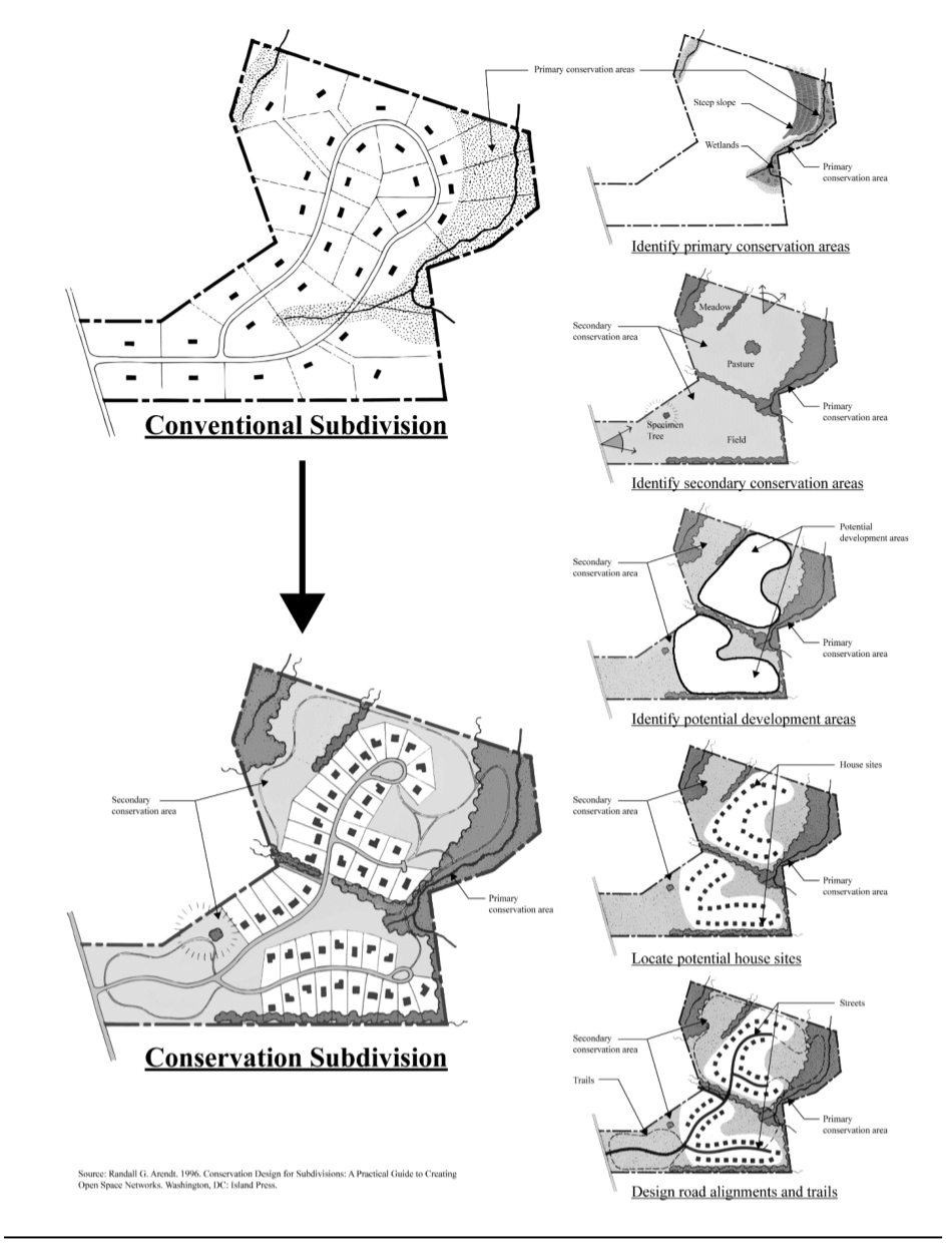
(C)Primary Conservation Areas. Primary conservation areas refer to the most ecologically sensitive and often severely constrained land, including land as shown in Table 19.1. A conservation subdivision shall design process.
TABLE 19.1
| Primary Conservation Areas | Secondary Conservation Areas |
|---|---|
| Habitats for endangered or threatened species | Open meadows and/or pastures of 3 contiguous acres or more |
| Wetlands | Orchards |
| Flood plains | Existing forests of 3 contiguous acres or more |
| State waters, shorelines, and associated buffers | Specimen tree stands |
| Steep mountain slopes | Aquifer recharge areas |
| Steep slopes of 35% or greater | Slopes between 25% and 35% |
| Historic and Archeological sites | |
| Trails | |
| Trailheads constructed with pervious materials connecting to identified County trails |
Reading grid · rebuilt for display · verify at source (p. 266) ↗
§ 19-3.2
Standards for Open Space.
This section provides standards and guidelines for establishing open space.
(A)Location. When a conservation subdivision site abuts an existing conservation area, park, nature preserve, or public undeveloped land, such as the 1085 line of the U.S. Army Corps of Engineers around Lake Lanier, conservation areas shall be designed so that they are located along the common boundary line.
(B)Trails. Open space shall provide for trails, between ten (10) and twelve (12) feet wide and shall be designed to connect with a sidewalk network and/or function as pathways to active amenity areas or other common areas. Trails are required to be located external to individual residential lots and are not intended to be accessed via easements through individual residential lots. No trail located within open space may include impervious materials. Motorized vehicles shall not be permitted on trails except for maintenance, construction, or public safety purposes. This prohibition shall be included within the required covenants. Where appropriate and convenient, such trails shall be made handicapped accessible. Connection to off-site County trails is strongly encouraged.
(C)Trail/Street Crossings. Where trail systems cross an internal subdivision street, the access points shall be directly across from each other, clearly identified both to the motorist and pedestrian, and located with appropriate sight distance as determined by the Director of Engineering, subject to the approval of the Engineering Department. Where a trail crosses any County road not interior to the subdivision, the trail shall be grade separated (i.e., by a tunnel or bridge), or located at a traffic control device approved by the Director of Engineering and Planning Director.
(D)Limits of Disturbance. No clearing or grading shall be permitted in the primary or secondary conservation areas with the following exemptions:
(1)Encroachments for infrastructure and stormwater shall be granted only for perpendicular buffer crossings that have been reviewed and approved per Chapter 18, Article XI.
(2)Removal of vegetation as identified on the United States Department of Agriculture Georgia List of Exotic and Invasive Plants is permitted provided such removal is minimal. This exemption shall not apply to undisturbed state and county stream buffers.
(E)Tree Cover. Preservation and enhancement of existing tree canopy is strongly desired and encouraged wherever possible but at minimum, must be consistent with the Forsyth County Tree Ordinance.
(F)Permitted Uses. For the purposes of this chapter, open space may be used for primary conservation area and secondary conservation area. Pervious surface trails for passive recreation may be allowed.
(G)Active Amenity Areas. Active amenity areas, if provided, shall not be located in the primary or secondary conservation areas and shall not count toward required open space.
(H)Golf Courses Prohibited. Golf courses do not comply with the conservation intent of this chapter and thus are not permitted.
Rebuilt from the published figure · verify at source (p. 267) ↗
CONSERVATION SUBDIVISION DESIGN PROCESS
ARTICLE IV, DETERMINING LOT YIELD: