Chapter 19 — Conservation Subdivisions, Article 7 — PROCEDURES
Pre-application Conference.
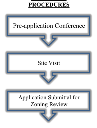
A pre-application conference with the department is required at least fourteen (14) days prior to the submission of a rezoning or sketch plat application. Once scheduled, county staff shall notify the appropriate district commissioner of the meeting date and time. At the time of a pre-application conference, an Existing Features and Site Analysis Report, as detailed in section 19-7.2, shall be submitted and a site visit, as detailed in section 19-7.3, shall be scheduled. In the event amendments to the Existing Features and Site Analysis Report are necessary as a result of information gathered during the site visit, an updated report shall be submitted in accordance with 19-7.3. Refer to figure 19.2 for guidance on the order of procedures. At the applicant’s request, the department shall make available all relevant information about primary and secondary conservation areas, including soil survey, natural resource maps, and geographic information, for which reasonable reproduction costs for this information may be charged. Ideally, the pre-application conference will be preceded by the submittal of a boundary survey of the property to be subdivided with sufficient time for the Department to collect applicable information.
Existing Features and Site Analysis Report.
The purpose of the existing features and site analysis report is to familiarize County staff with existing site conditions and shall form the basis for the development design as shown on the concept plan. This report shall consist of a map and narrative identifying and describing all important existing site features in accordance with the list below and shall be sealed by a registered engineer or landscape architect to ensure accuracy. The following features shall be included where applicable:
Site Visit.
The purpose of the site visit is to familiarize staff with the property's existing conditions and special features, to identify potential site design issues, and to provide an informal opportunity to discuss site design concepts, including the general layout of the designated open space areas and potential locations for proposed buildings and street alignments. Comments made by staff regarding design shall be interpreted as being only suggestive. It shall be understood by all parties that no formal recommendations will be offered, and no official decisions can be made during the site visit. In the event that staff determines that existing site features have not been fully represented within the Existing Features and Site Analysis Report, the applicant shall amend the report and submit it to accompany other application requirements in accordance with sections 8-5.4 and 8-5.5 of this Code, adhering to required departmental deadlines.
Yield Plan or Adjusted Tract Acreage Method.
Along with all other required documents and site plan submittals for rezoning and/or sketch plat applications, applicants shall submit one (1) of the following:
Pre-application Conference Site Visit Application Submittal for Zoning Review ARTICLE VIII, EASEMENTS AND OWNERSHIP: