LandCode
GainesvilleUnified Land Development Code

Article 8 — Site and Architectural Design Guidelines, Chapter 8-3 — SITE DESIGN GUIDELINES

current as of 2025-12-16verified current · checked 2026-08-24Officialofficial source11 sections · full chapter
§ 8-3-1

Purpose and Intent

This chapter provides guidelines for the design of land developments on individual sites and will be applied by the Community and Economic Development Department during the process of site design review as required by Chapter 8-2 of this Code.

§ 8-3-2

Applicability

Unless the context of a particular section clearly indicates otherwise, the site design guidelines of this chapter shall be considered by the Community and Economic Development Department to apply to all land developments and minor land developments.

§ 8-3-3

Cross Reference to Existing Code Requirements

At the time an application for preliminary plat is submitted, a proposed subdivision will be reviewed for compliance with existing code requirements, including but not limited to: Article 11, “Subdivisions and Land Development,” including specifically Chapter 11-3, “Design Requirements for Blocks and Lots”; Chapter 11-4, “Preliminary Plat”; and Chapter 11-8, “Design Requirements for Streets”. Designers should consult with Community and Economic Development department and Water Resources Department staff early in the process to identify key chapters and sections of this Code that impact site design.

§ 8-3-4

Existing Site Analysis

(a)Significant natural features of the site proposed to be developed should be identified on an existing conditions map and to the extent practicable incorporated into the site plan or plans for land development.
(b)The Community and Economic Development Department Director may exempt development proposals on properties with one acre or less in area, or minor land developments, from this requirement if, through a site visit or other information presented, the requirement for a site conditions analysis can be satisfied with other data and enforcing this requirement would be onerous given the development proposed.
(c)Properties with one acre or less in area shall be subject to stormwater requirements.

The Director of the Department of Water Resources may exempt properties with one acre or less in area from stormwater requirements contained in this Code if, through a site visit or other information presented, the stormwater requirements would be unduly onerous given the development proposed.

(d)In cases where significant natural water features such as floodplains, wetlands, and streams exist, exemptions should be decided on a case-by-case basis by the Director of the Department of Water Resources.
§ 8-3-5

Grading

(a)Developments should be designed to fit the existing contours and landform of the site and use of available buildable areas in the most space-efficient way to minimize clearing, grading, and earthwork and to reduce visual impacts and erosion.
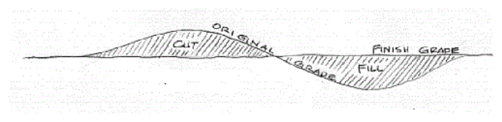
(b)Where cut and fill is required, balancing the cut and fill is highly encouraged.
Figure 8-1: Illustrative Cut and Fill
Rebuilt from the published figure · verify at source (p. 113)
(c)Abrupt or unnatural-appearing grading should not be proposed and will not be allowed. Land development activities in areas that have slopes greater than 25% should not be considered unless necessary for roadway or utility construction. See Chapter 13-8 for guidance on development on steep slopes.
(d)Grading should blend with the contours of adjacent properties with minimum alteration of the natural topography necessary to accomplish the development.
(e)Where retaining walls are required, the height and length of retaining walls should be minimized and screened with appropriate landscaping. Tall, smooth-faced concrete retaining walls should be avoided in highly visible areas. Terracing should be considered as an alternative to the use of tall or prominent retaining walls, particularly in highly visible areas on hillsides.
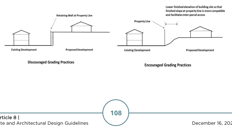
(f)When cut or fill is involved in the grading of an individual building pad or development site, the finished grade of the parking lot or driveway should be terminated far enough inside the property to allow for the slope to return to that of the natural grade or finished ground elevation at the property line. When inter-parcel access is provided or required, the slope at such a property line shall not exceed 10%. The purposes of this design guideline are to both facilitate inter-parcel access at reasonable grades between compatible land uses and to avoid harsh differences in grade between abutting properties. This practice also provides for a blending of the finished site elevations in a manner so that stark contrasts in the landscape will not occur. Where inter-parcel access is not required due to incompatible land uses, grade differentiation at a property line may be permitted but should be mitigated or softened as much as possible (see illustration below).
Figure 8-2: Discouraged and Encouraged Grading Practices
Rebuilt from the published figure · verify at source (p. 113)
(g)Specific grading design criteria for stormwater best management practices should be followed as set forth in the latest revision of the Georgia Stormwater Management Manual (GSMM).
§ 8-3-6

Stormwater Management Generally

(a)Stormwater management is governed by Chapter 11-11 of this ULDC. One- and two-family dwellings are exempt except as otherwise specified in Section 11-11-6.
(b)Land developers should utilize, to the maximum extent practicable, stormwater Better Site Design practices as described in the latest revision of the GSMM.
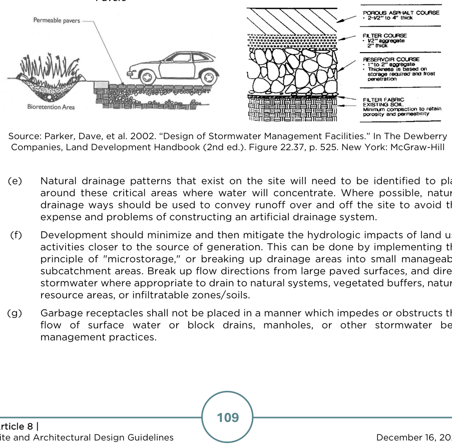
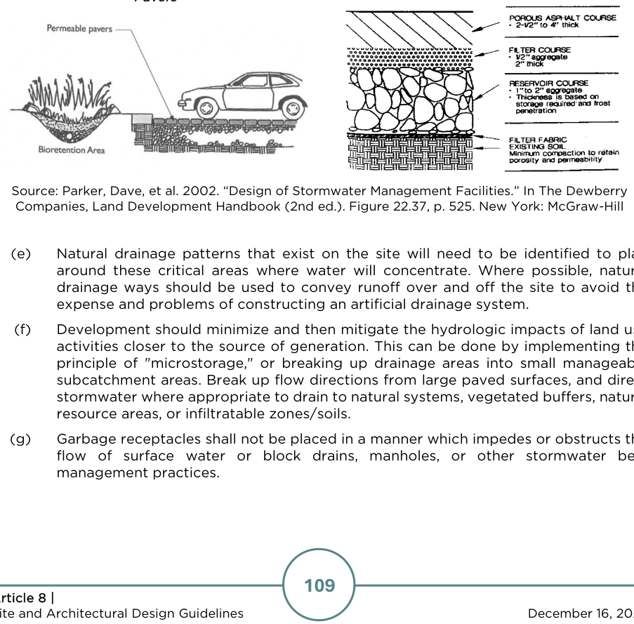
(c)To improve infiltration, porous paving materials are encouraged for certain applications. Porous paving materials include porous concrete, porous asphalt, porous unit paver systems, and gravel paving systems.
(d)Grassy swales and bio-retention areas are acceptable and encouraged alternatives to curbing, piping, and detention of water. Where curb is necessary, a curb cut should be used to direct runoff to swales or bioretention areas. Rain gardens and constructed wetlands are also encouraged to handle surface drainage of parking lots providing 10 or more parking spaces.
Figure 8-3: Bioretention Area and Permeable
Rebuilt from the published figure · verify at source (p. 114)

Pavers

Figure 8-4: Porous Asphalt Paving Section
Rebuilt from the published figure · verify at source (p. 114)

Source: Parker, Dave, et al. 2002. “Design of Stormwater Management Facilities.” In The Dewberry Companies, Land Development Handbook (2nd ed.). Figure 22.37, p. 525. New York: McGraw-Hill
(e)Natural drainage patterns that exist on the site will need to be identified to plan around these critical areas where water will concentrate. Where possible, natural drainage ways should be used to convey runoff over and off the site to avoid the expense and problems of constructing an artificial drainage system.
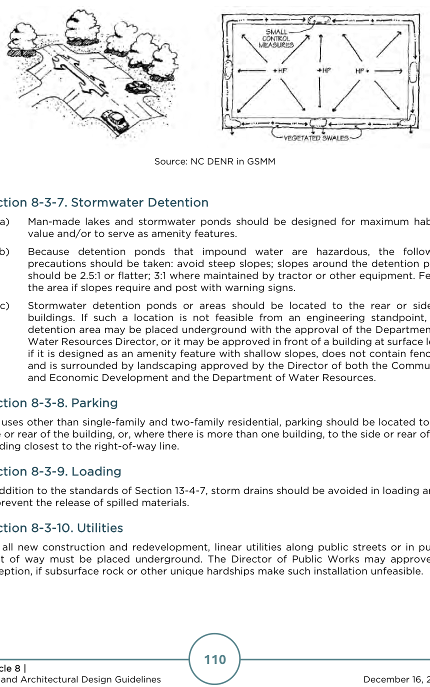
(f)Development should minimize and then mitigate the hydrologic impacts of land use activities closer to the source of generation. This can be done by implementing the principle of "microstorage," or breaking up drainage areas into small manageable subcatchment areas. Break up flow directions from large paved surfaces, and direct stormwater where appropriate to drain to natural systems, vegetated buffers, natural resource areas, or infiltratable zones/soils.
(g)Garbage receptacles shall not be placed in a manner which impedes or obstructs the flow of surface water or block drains, manholes, or other stormwater best management practices.
Figure 8-5: Design Paved Surfaces to Disperse Flow to Vegetated Areas
Rebuilt from the published figure · verify at source (p. 115)

Source: NC DENR in GSMM

§ 8-3-7

Stormwater Detention

(a)Man-made lakes and stormwater ponds should be designed for maximum habitat value and/or to serve as amenity features.
(b)Because detention ponds that impound water are hazardous, the following precautions should be taken: avoid steep slopes; slopes around the detention pond should be 2.5:1 or flatter; 3:1 where maintained by tractor or other equipment. Fence the area if slopes require and post with warning signs.
(c)Stormwater detention ponds or areas should be located to the rear or side of buildings. If such a location is not feasible from an engineering standpoint, the detention area may be placed underground with the approval of the Department of Water Resources Director, or it may be approved in front of a building at surface level if it is designed as an amenity feature with shallow slopes, does not contain fencing, and is surrounded by landscaping approved by the Director of both the Community and Economic Development and the Department of Water Resources.
§ 8-3-8

Parking

For uses other than single-family and two-family residential, parking should be located to the side or rear of the building, or, where there is more than one building, to the side or rear of the building closest to the right-of-way line.

§ 8-3-9

Loading

In addition to the standards of Section 13-4-7, storm drains should be avoided in loading areas to prevent the release of spilled materials.

§ 8-3-10

Utilities

For all new construction and redevelopment, linear utilities along public streets or in public right of way must be placed underground. The Director of Public Works may approve an exception, if subsurface rock or other unique hardships make such installation unfeasible.

§ 8-3-11

Interparcel Access

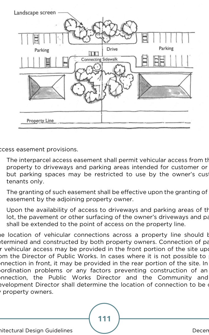
(a)For any office or retail sales or services use, the property owner shall grant an access easement as described in this section to each adjoining property that is zoned or used for an office or retail sales or services use. The purpose of the easement is to facilitate movement of customers and their vehicles without generating additional turning movements on a public street. When required by this section, interparcel access easements shall be recorded in the office of the Clerk of Superior Court, Hall County, and reference to deed book and copy of such recorded easement provided to the Director.
Figure 8-6: Illustrative Interparcel Access
Rebuilt from the published figure · verify at source (p. 116)
(b)Access easement provisions.
(1)The interparcel access easement shall permit vehicular access from the adjoining property to driveways and parking areas intended for customer or tenant use;

but parking spaces may be restricted to use by the owner’s customers and tenants only.

(2)The granting of such easement shall be effective upon the granting of a reciprocal easement by the adjoining property owner.
(3)Upon the availability of access to driveways and parking areas of the adjoining lot, the pavement or other surfacing of the owner’s driveways and parking areas shall be extended to the point of access on the property line.
(c)The location of vehicular connections across a property line should be mutually determined and constructed by both property owners. Connection of parking areas for vehicular access may be provided in the front portion of the site upon approval from the Director of Public Works. In cases where it is not possible to provide the connection in front, it may be provided in the rear portion of the site. In the case of coordination problems or any factors preventing construction of an interparcel connection, the Public Works Director and the Community and Economic Development Director shall determine the location of connection to be constructed by property owners.
(d)Where the proposed land use is such that adverse impact of the required easement on the use of the property would outweigh the reduced impact on the public street provided by the reciprocal easements, the Director may waive the requirement for access easements, in whole or in part, administratively.